ALERTCalifornia (@alertcalifornia) 's Twitter Profile
ALERTCalifornia

@alertcalifornia

UC San Diego public safety program leveraging novel technology & cutting-edge research to understand the causes, behavior & aftereffects of natural disasters.

ID: 1027245087883841536

linkhttps://alertcalifornia.org calendar_today08-08-2018 17:28:09

2,2K Tweet

30,30K Followers

255 Following

ALERTCalifornia (@alertcalifornia) 's Twitter Profile Photo

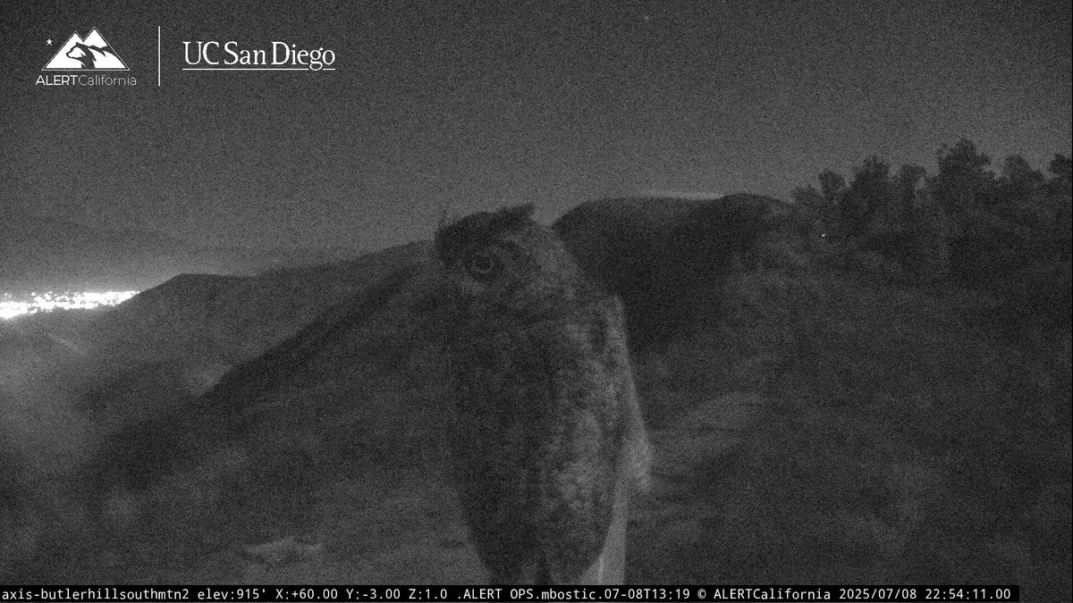
Spotted this beautiful barn owl perched in front of the Butler Hill South Mountain 2 ALERTCalifornia camera in Oxnard earlier this week. Check conditions, or go birdwatching, across the state at cameras.alertcalifornia.org

Spotted this beautiful barn owl perched in front of the Butler Hill South Mountain 2 ALERTCalifornia camera in Oxnard earlier this week. Check conditions, or go birdwatching, across the state at cameras.alertcalifornia.org
CAL FIRE (@cal_fire) 's Twitter Profile Photo

🔥 Planning a camping trip? Make sure your campfire doesn't spark a wildfire. Whether you're new to the outdoors or a seasoned pro, knowing how to safely light, manage, and extinguish a campfire is critical. ✅ Get your FREE campfire permit: readyforwildfire.org/permits/ ✅ Check

ALERTCalifornia (@alertcalifornia) 's Twitter Profile Photo

New cameras online: Goat Mtn Lookout 1 & 2 were placed at the Goat Mountain Fire Lookout. No longer staffed but included in the National Historic Fire Register, the tower was erected in 1934 and overlooks Bass Lake and the Sierra National forest. Live view bit.ly/3ZFJN80

New cameras online: Goat Mtn Lookout 1 & 2 were placed at the Goat Mountain Fire Lookout. No longer staffed but included in the National Historic Fire Register, the tower was erected in 1934 and overlooks Bass Lake and the Sierra National forest. Live view bit.ly/3ZFJN80
ALERTCalifornia (@alertcalifornia) 's Twitter Profile Photo

Time lapse of California condors roosting within view of ALERTCalifornia's Blue Mtn Kern cameras. This location is a condor hot spot during the summer and is a great place to look for the birds in the mornings and evenings. Check live at bit.ly/4l05GqX

ALERTCalifornia (@alertcalifornia) 's Twitter Profile Photo

New cameras online: Cedar Mill 1 & 2 were recently installed near the community of Pioneer in Amador County. These new sensors bring us to more than 1,170 ALERTCalifornia natural hazard monitoring cameras across the state 📹 🔥 ⛈️ Live view: bit.ly/3I1snww

New cameras online: Cedar Mill 1 & 2 were recently installed near the community of Pioneer in Amador County. These new sensors bring us to more than 1,170 ALERTCalifornia natural hazard monitoring cameras across the state 📹 🔥 ⛈️  
Live view: bit.ly/3I1snww
ALERTCalifornia (@alertcalifornia) 's Twitter Profile Photo

Compilation time-lapse of the start and afternoon growth of the #LakeFire in San Bernardino County seen from multiple ALERTCalifornia cameras. Look to @calfirebdu for incident updates and see conditions live at: bit.ly/4noqOsv

ALERTCalifornia (@alertcalifornia) 's Twitter Profile Photo

Compilation video from three ALERTCalifornia cameras that captured the start and afternoon growth of the Wolf Fire in Riverside County on 6/29. Watch on YT: bit.ly/4nGNSTM Look to CAL FIRE/Riverside County Fire Department for incident updates. See conditions live: bit.ly/4niZqMC

Compilation video from three ALERTCalifornia cameras that captured the start and afternoon growth of the Wolf Fire in Riverside County on 6/29. Watch on YT: bit.ly/4nGNSTM Look to <a href="/CALFIRERRU/">CAL FIRE/Riverside County Fire Department</a> for incident updates. 
See conditions live: bit.ly/4niZqMC
CAL FIRE (@cal_fire) 's Twitter Profile Photo

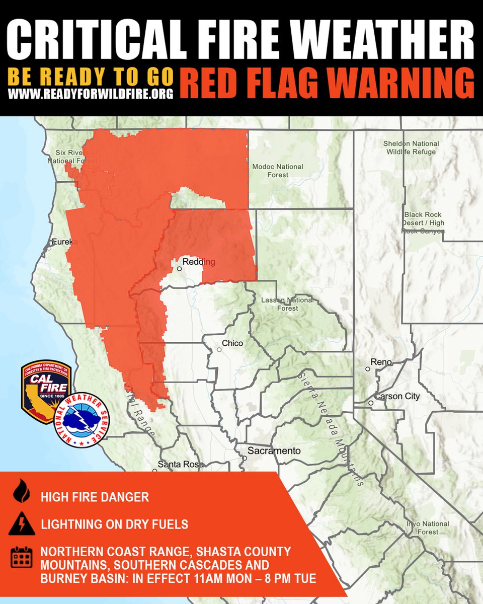
A Red Flag Warning is in effect for much of interior Northern California through Tuesday evening due to thunderstorm activity and gusty winds. These conditions dramatically increase the risk of rapid wildfire spread within the Northern coastal range, Shasta County Mountains,

A Red Flag Warning is in effect for much of interior Northern California through Tuesday evening due to thunderstorm activity and gusty winds.

These conditions dramatically increase the risk of rapid wildfire spread within the Northern coastal range, Shasta County Mountains,
ALERTCalifornia (@alertcalifornia) 's Twitter Profile Photo

Afternoon growth of the #JuniperFire in Riverside County seen from ALERTCalifornia's Santiago Peak CalOES North camera. Look to CAL FIRE/Riverside County Fire Department for incident updates and check conditions live at bit.ly/44GjrFz
CAL FIRE LNU (@calfirelnu) 's Twitter Profile Photo

The #CherryFire at I-80 and the Cherry Glen Road off-ramp in Vacaville burned 8.35 acres Monday and is now 90 percent contained. Firefighters will be back checking on the site for several days to ensure the fire is completely under control. This photo is from ALERTCalifornia
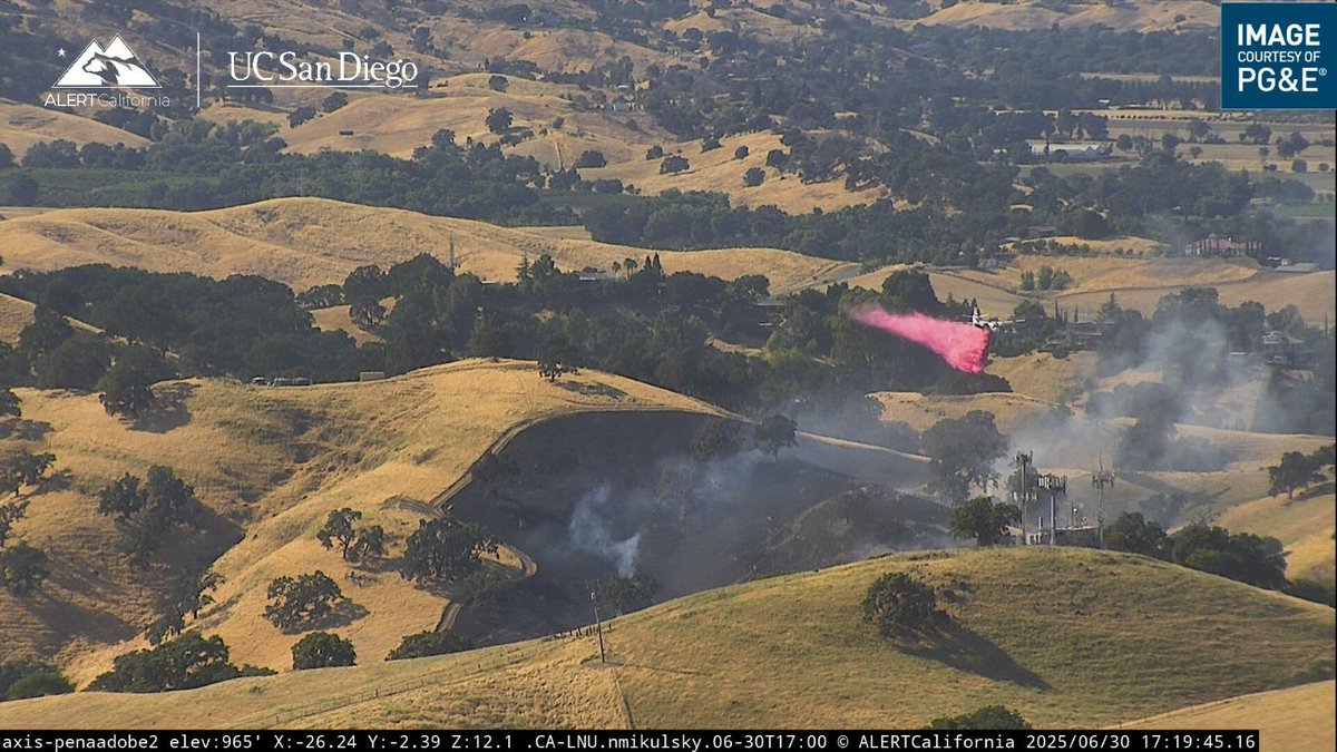
The #CherryFire at I-80 and the Cherry Glen Road off-ramp in Vacaville burned 8.35 acres Monday and is now 90 percent contained. Firefighters will be back checking on the site for several days to ensure the fire is completely under control.

This photo is from <a href="/ALERTCalifornia/">ALERTCalifornia</a>
ALERTCalifornia (@alertcalifornia) 's Twitter Profile Photo

Female California condor 599 was spotted on the Whitaker Middle Peak 2 camera this morning. This ALERTCalifornia camera is not far from Ventura County's Sespe Condor Sanctuary. Look for condors and other wildlife across the state at cameras.alertcalifornia.org

Female California condor 599 was spotted on the Whitaker Middle Peak 2 camera this morning. This ALERTCalifornia camera is not far from Ventura County's Sespe Condor Sanctuary. Look for condors and other wildlife across the state at cameras.alertcalifornia.org
ALERTCalifornia (@alertcalifornia) 's Twitter Profile Photo

Sunrise views from the Mt. David North ALERTCalifornia camera shows lingering smoke from the #WolfFire through the mountains and the San Gorgonio Pass towards Banning. Look to @Calfirerru for updates and see conditions live at bit.ly/3Thykb7

Sunrise views from the Mt. David North ALERTCalifornia camera shows lingering smoke from the #WolfFire through the mountains and the San Gorgonio Pass towards Banning. Look to @Calfirerru for updates and see conditions live at bit.ly/3Thykb7
ALERTCalifornia (@alertcalifornia) 's Twitter Profile Photo

Compilation video of the start and growth of the #MadreFire in San Luis Obispo County on 7/2 from multiple ALERTCalifornia cameras. Watch on YT: bit.ly/3Ir9cw8 and check current conditions at: bit.ly/4ex8Vnr. Look to San Luis Obispo County Fire Department and SLO County OES for updates.
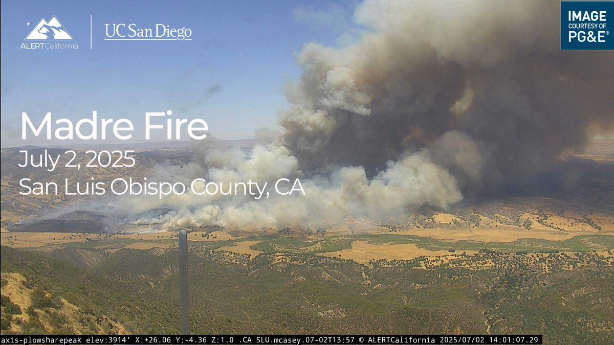
Compilation video of the start and growth of the #MadreFire in San Luis Obispo County on 7/2 from multiple ALERTCalifornia cameras. Watch on YT: bit.ly/3Ir9cw8 and check current conditions at: bit.ly/4ex8Vnr. Look to <a href="/CALFIRE_SLO/">San Luis Obispo County Fire Department</a> and <a href="/slocountyoes/">SLO County OES</a> for updates.
ALERTCalifornia (@alertcalifornia) 's Twitter Profile Photo

Sunset into the evening time-lapse of the #MadreFire in San Luis Obispo County on 7/3 from ALERTCalifornia's McKittrick Summit North camera. Check current conditions at: bit.ly/4ex8Vnr. Look to San Luis Obispo County Fire Department and SLO County OES for updates.

ALERTCalifornia (@alertcalifornia) 's Twitter Profile Photo

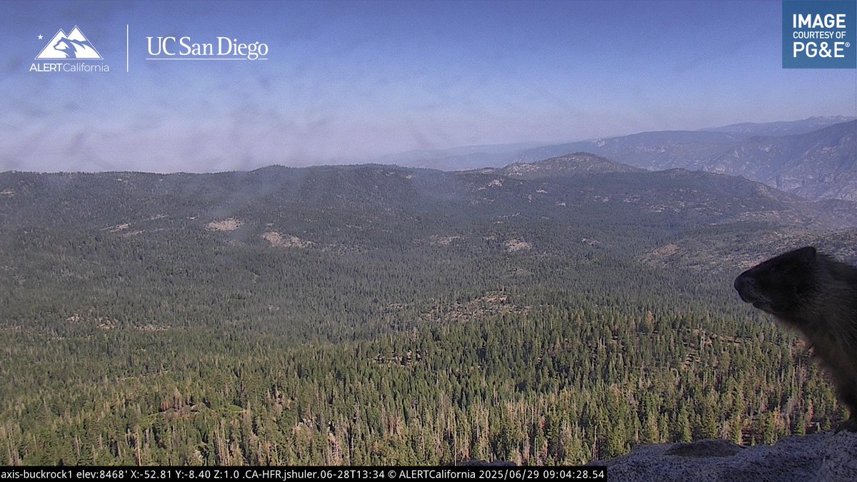
We spotted the marmot on the Buck Rock 1 camera again! We are big fans. Does anyone know if it has a name? Check out the view from the iconic Buck Rock Fire Lookout in Sequoia National Forest at bit.ly/45bHexZ

We spotted the marmot on the Buck Rock 1 camera again! We are big fans. Does anyone know if it has a name? Check out the view from the iconic Buck Rock Fire Lookout in Sequoia National Forest at bit.ly/45bHexZ
ALERTCalifornia (@alertcalifornia) 's Twitter Profile Photo

ALERTCalifornia researchers recently collaborated on an Englekirk Structural Engineering Center shake table experiment. Our team collected drone and sensor data during the two weeks of earthquake simulations run on this 10-story, 100-foot structure. bit.ly/3IxMi6k

CAL FIRE CZU (@calfireczu) 's Twitter Profile Photo

Firefighters from multiple agencies are responding to a fire near Hill House Road in Santa Cruz County. #CaWx You can watch the smoke LIVE on ALERTCalifornia here: cameras.alertcalifornia.org/?pos=37.2153_-… Santa Cruz County

ALERTCalifornia (@alertcalifornia) 's Twitter Profile Photo

This time-lapse shows the start and growth of the #SpringsFire in San Diego County captured by ALERTCalifornia's Lyons Peak 1 camera. Check conditions: bit.ly/3GtXq3H & look to CAL FIRE/San Diego County Fire for updates. The clip also shows the historic Lyons Peak Lookout FFLA San Diego Riverside Chapter

ALERTCalifornia (@alertcalifornia) 's Twitter Profile Photo

This structure within view of ALERTCalifornia Butler Hill South Mtn 2 camera, east of Ventura, is a bird hotspot. We've seen so many species, including this recent great horned owl. We checked the archive and there was a barn owl sitting in the same place about 3 weeks ago. 🦉

This structure within view of ALERTCalifornia Butler Hill South Mtn 2 camera, east of Ventura, is a bird hotspot. We've seen so many species, including this recent great horned owl. We checked the archive and there was a barn owl sitting in the same place about 3 weeks ago. 🦉