Alex Countee (@alexcounteewx) 's Twitter Profile
Alex Countee

@alexcounteewx

Weekend AM Meteorologist @fox4kc l @ametsoc CBM #906 I Emmy Nominated l @KansasCity Native l @Mizzou Meteorology Class of 2017

ID: 872167215528914944

linkhttp://fox4kc.com/weather calendar_today06-06-2017 19:04:03

7,7K Tweet

1,1K Followers

1,1K Following

Dale Sams ©️ (@dalesamswx) 's Twitter Profile Photo

4:02am - 5" of rainfall currently in Independence, MO maxxed out rain gauge. I have recorded time and the amount and emptied the gauge to continue accumulating rainfall. Flash Flood Warning effect till 7am. NWS Kansas City hanna ✰🌪️🌩️🪦 Fox 4 Weather KC Jim Cantore Meteorologist Warren Sears #kcwx

4:02am - 5" of rainfall currently in Independence, MO maxxed out rain gauge. I have recorded time and the amount and emptied the gauge to continue accumulating rainfall. 

Flash Flood Warning effect till 7am. <a href="/NWSKansasCity/">NWS Kansas City</a> <a href="/hellohannav/">hanna ✰🌪️🌩️🪦</a> <a href="/fox4wx/">Fox 4 Weather KC</a> <a href="/JimCantore/">Jim Cantore</a> <a href="/WarrenKCTV5/">Meteorologist Warren Sears</a> #kcwx
NWS Kansas City (@nwskansascity) 's Twitter Profile Photo

KC as of 6:40am has already picked up 2.04" of rain for the day. That makes it the second consecutive day (yesterday KC had 2.78") KC has received over two inches. This ties the record for consecutive days of 2 inches or more at KC which has occurred 12 times in 137 years.

Dale Sams ©️ (@dalesamswx) 's Twitter Profile Photo

7:30am *STORM TOTAL*: Rain has ended here in Independence,MO. At 4am this morning I measured 5" of rain. Rain wrapped up with storm total of 7"! Run off drains are doing their part. NWS Kansas City Fox 4 Weather KC Nick Bender Alex Countee hanna ✰🌪️🌩️🪦 #kcwx #mowx
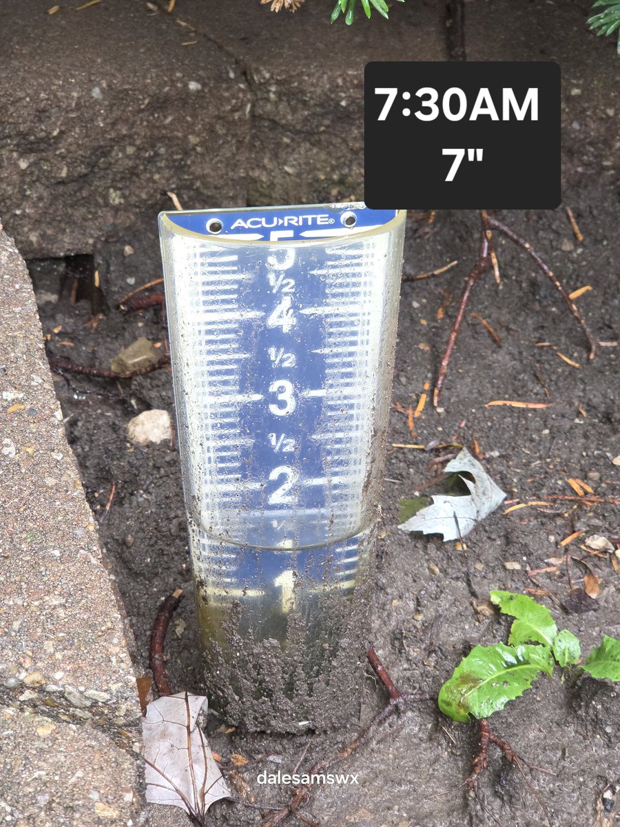
7:30am *STORM TOTAL*: 

Rain has ended here in Independence,MO. At 4am this morning I measured 5" of rain. Rain wrapped up with storm total of 7"! Run off drains are doing their part. <a href="/NWSKansasCity/">NWS Kansas City</a> <a href="/fox4wx/">Fox 4 Weather KC</a> <a href="/NickBenderKMBC/">Nick Bender</a> <a href="/AlexCounteeWX/">Alex Countee</a> <a href="/hellohannav/">hanna ✰🌪️🌩️🪦</a> #kcwx #mowx
Fox 4 Weather KC (@fox4wx) 's Twitter Profile Photo

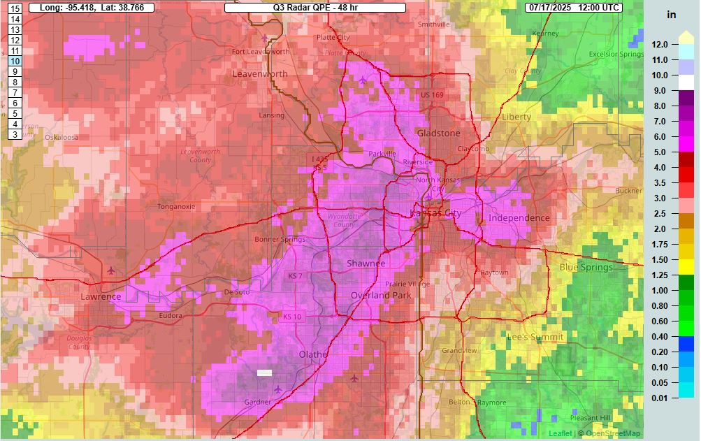
Radar indicated rain totals over the past 48 hours...notice the scale on the right. Almost 15 TIMES more rain from southeastern Cass Co to JOCO KS. JL #mowx #kswx #kansascity

Radar indicated rain totals over the past 48 hours...notice the scale on the right. Almost 15 TIMES more rain from southeastern Cass Co to JOCO KS. JL #mowx #kswx #kansascity
Alex Countee (@alexcounteewx) 's Twitter Profile Photo

Just wild how much rain we picked up since yesterday afternoon. Rain icons on the map are actual reports of 8-9”. Pink is estimated 5”+, blue is 7”+, up to that red spot north of Gardner at 10”+. Just under 5” at KCI since yesterday! FOX4 News Kansas City #KCwx
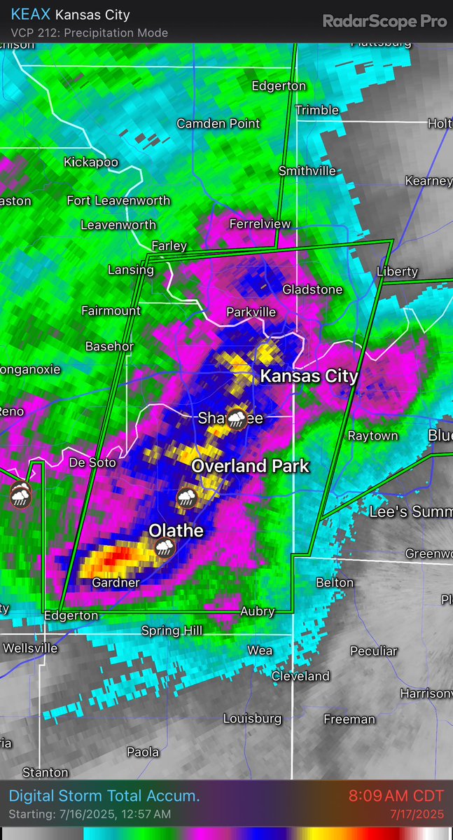
Just wild how much rain we picked up since yesterday afternoon. Rain icons on the map are actual reports of 8-9”. Pink is estimated 5”+, blue is 7”+, up to that red spot north of Gardner at 10”+. Just under 5” at KCI since yesterday! <a href="/fox4kc/">FOX4 News Kansas City</a> #KCwx
NWS Kansas City (@nwskansascity) 's Twitter Profile Photo

Good morning! We are looking for wind reports from overnight. Did you see any tree damage or have an estimate of winds speeds? Let us know, thanks!

DeAnna Blair (@deannalblair) 's Twitter Profile Photo

Not verified Fox 4 Weather KC but 9.7" may break a 40 year record at our house!Plus wind💨 that breaks a 40-year old ash🏡 #morethanweneeded ☔️#fox4kc #kswx #kswx John Holt Karli Ritter Michelle Bogowith #weatheraware

Not verified <a href="/fox4wx/">Fox 4 Weather KC</a> but 9.7" may break a 40 year record at our house!Plus wind💨 that breaks a 40-year old ash🏡 #morethanweneeded ☔️#fox4kc #kswx #kswx <a href="/JohnHoltNews/">John Holt</a> <a href="/KarliRitter/">Karli Ritter</a> <a href="/MBogowith/">Michelle Bogowith</a> #weatheraware
Jacob Lanier (@jacoblanierwx) 's Twitter Profile Photo

Big time rain numbers from Wednesday night/Thursday morning in the Kansas City Metro. 🌧️ The EXTREME rain zone was over Wyandotte & Johnson counties with 8-10". It was a drastic cut off down to 1" in eastern Jackson Co. Record rainfall!! FOX4 News Kansas City #KCwx #MOwx #KSwx

Big time rain numbers from Wednesday night/Thursday morning in the Kansas City Metro. 🌧️ The EXTREME rain zone was over Wyandotte &amp; Johnson counties with 8-10". It was a drastic cut off down to 1" in eastern Jackson Co. Record rainfall!! <a href="/fox4kc/">FOX4 News Kansas City</a> #KCwx #MOwx #KSwx
Fox 4 Weather KC (@fox4wx) 's Twitter Profile Photo

There were parts of JOCO KS that had over 10" of rain in ~12 hours...how rare is that? It's a 1 in 500 year type of event or a .2% chance of happening in any given year. JL #flood #fox4kc #kcwx #kswx

FOX4 News Kansas City (@fox4kc) 's Twitter Profile Photo

Kansas City Kansas saw upwards of 10 inches of rain in just 12 hours late Wednesday night and early Thursday morning. fox4kc.com/news/kansas-ci…

Kansas City Kansas saw upwards of 10 inches of rain in just 12 hours late Wednesday night and early Thursday morning. fox4kc.com/news/kansas-ci…
Alex Countee (@alexcounteewx) 's Twitter Profile Photo

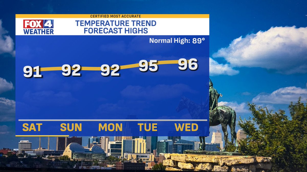
Happy Saturday! After a drier day yesterday after the flooding, the forecast continues to slowly dry out. Today may still have some AM/midday clouds & showers, potentially slowing down the heating process. Similar cloud/rain issues Sunday & Monday before higher heat. FOX4 News Kansas City

Happy Saturday! After a drier day yesterday after the flooding, the forecast continues to slowly dry out. Today may still have some AM/midday clouds &amp; showers, potentially slowing down the heating process. Similar cloud/rain issues Sunday &amp; Monday before higher heat. <a href="/fox4kc/">FOX4 News Kansas City</a>
Jacob Lanier (@jacoblanierwx) 's Twitter Profile Photo

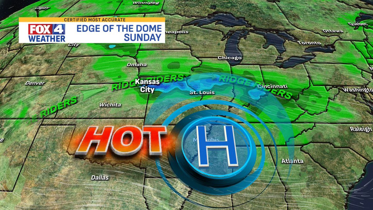
Kansas City is still on the edge of the heat dome which is positioned over the Deep South. That allows scattered "ridge rider" storms to still impact parts of our region Sunday & Monday before the high moves overhead & temps climb. FOX4 News Kansas City #KCwx #MOwx #KSwx

Kansas City is still on the edge of the heat dome which is positioned over the Deep South. That allows scattered "ridge rider" storms to still impact parts of our region Sunday &amp; Monday before the high moves overhead &amp; temps climb. <a href="/fox4kc/">FOX4 News Kansas City</a> #KCwx #MOwx #KSwx
Alex Countee (@alexcounteewx) 's Twitter Profile Photo

Happy Sunday! Sct'd storms are out there north & west of town with mostly cloudy skies. It may be hard to have multiple hours of sun today as the KS activity moves in midday & this afternoon. Highs should be near 90° again today! FOX4 News Kansas City #MOwx #KSwx #KCwx
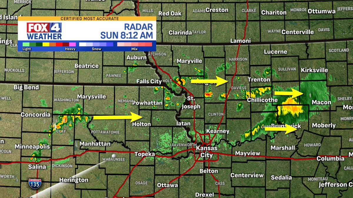
Happy Sunday! Sct'd storms are out there north &amp; west of town with mostly cloudy skies. It may be hard to have multiple hours of sun today as the KS activity moves in midday &amp; this afternoon. Highs should be near 90° again today! <a href="/fox4kc/">FOX4 News Kansas City</a> #MOwx #KSwx #KCwx
Alex Countee (@alexcounteewx) 's Twitter Profile Photo

10 AM FEELS LIKE -- I mentioned on-air that there will be breaks in the clouds, allowing the heat index to flare up at times today. That's happening now south of I-70 with more sunshine. It's already nasty down there! 100-105° feels like temps are possible for some today! FOX4 News Kansas City

10 AM FEELS LIKE -- I mentioned on-air that there will be breaks in the clouds, allowing the heat index to flare up at times today. That's happening now south of I-70 with more sunshine. It's already nasty down there! 100-105° feels like temps are possible for some today! <a href="/fox4kc/">FOX4 News Kansas City</a>