ArcGIS Online (@arcgisonline) 's Twitter Profile
ArcGIS Online

@arcgisonline

Create and share interactive web maps and apps with ArcGIS Online, Esri's cloud-based mapping software.

ID: 2314451911

linkhttp://esri.com/ArcGISOnline calendar_today27-01-2014 22:50:17

3,3K Tweet

22,22K Followers

274 Following

ArcGIS Enterprise (@arcgisxprise) 's Twitter Profile Photo

Check out this NEW #GISinaMinute video to learn how administrators can access, run, and schedule administrative reports to manage resources, such as members and content, in #ArcGISEnterprise and ArcGIS Online. Watch now ➡️ ow.ly/4EeI50VoYSm

Check out this NEW #GISinaMinute video to learn how administrators can access, run, and schedule administrative reports to manage resources, such as members and content, in #ArcGISEnterprise and <a href="/ArcGISOnline/">ArcGIS Online</a>. 

Watch now ➡️ ow.ly/4EeI50VoYSm
ArcGIS Online (@arcgisonline) 's Twitter Profile Photo

Elevation layers in #ArcGISLivingAtlas have been updated with high-resolution lidar data! Check out the latest improvements in #ArcGISOnline. Explore now: ow.ly/tJv650UQt9Z

ArcGIS Online (@arcgisonline) 's Twitter Profile Photo

Collaborate seamlessly between engineers and environmental scientists with #ArcGISGeoBIM in #ArcGISOnline. Minimize environmental impacts and comply with regulations using. Explore today: ow.ly/1EEJ50UTnGC

ArcGIS Online (@arcgisonline) 's Twitter Profile Photo

A big thank you to the Open Geospatial Consortium (OGC) for highlighting Esri’s adoption of Google’s Photorealistic 3D Tiles and our commitment to open standards. Learn more about how #Esri is accelerating an open geospatial future. Read the article here: ow.ly/aqcX50VMh6k

A big thank you to the Open Geospatial Consortium (OGC) for highlighting Esri’s adoption of Google’s Photorealistic 3D Tiles and our commitment to open standards. Learn more about how #Esri is accelerating an open geospatial future. Read the article here: ow.ly/aqcX50VMh6k
ArcGIS Online (@arcgisonline) 's Twitter Profile Photo

Leverage the power of collaboration in #ArcGISOnline and #Enterprise. Read this blog to learn how to connect and share data between organizations. Explore today: ow.ly/yCz650UQtgG

Leverage the power of collaboration in #ArcGISOnline and #Enterprise. Read this blog to learn how to connect and share data between organizations. 

Explore today: ow.ly/yCz650UQtgG
ArcGIS Online (@arcgisonline) 's Twitter Profile Photo

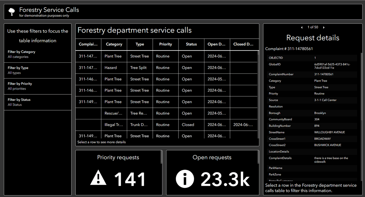
Designing effective dashboards means clear data visualization & digital accessibility for all, including those using assistive technologies. Discover new features from the June 2024 #ArcGISOnline update for broader accessibility. Start creating today: ow.ly/RNYM50Vavri

Designing effective dashboards means clear data visualization &amp; digital accessibility for all, including those using assistive technologies. Discover new features from the June 2024 #ArcGISOnline update for broader accessibility.  

Start creating today: 
ow.ly/RNYM50Vavri
ArcGIS Online (@arcgisonline) 's Twitter Profile Photo

Floods are frequent, yet half the world faces water scarcity. Now, you can include the Streamflow Viewer public map created with #ArcGISInstantApps in #ArcGISOnline in your daily routine. Check it out: esri.social/Efc050Us0hM

Floods are frequent, yet half the world faces water scarcity. Now, you can include the Streamflow Viewer public map created with #ArcGISInstantApps in #ArcGISOnline in your daily routine.  

Check it out: esri.social/Efc050Us0hM
ArcGIS Online (@arcgisonline) 's Twitter Profile Photo

With #ArcGISOnline, OregonOEM now offers a comprehensive, real-time view of emergencies, aiding partners and saving lives. Learn more: esri.social/8zto50U2J5P

With #ArcGISOnline, <a href="/OregonOEM/">OregonOEM</a> now offers a comprehensive, real-time view of emergencies, aiding partners and saving lives.  

Learn more: esri.social/8zto50U2J5P
ArcGIS Online (@arcgisonline) 's Twitter Profile Photo

Check out the Drought Aware App in #ArcGISOnline and its layers in #ArcGISLivingAtlas for detailed drought impact summaries! The app updates weekly with the U.S. Drought Monitor map release and's automated using a live feed routine. Read more: ow.ly/77h450UTnJz

ArcGIS Online (@arcgisonline) 's Twitter Profile Photo

We plan to update #ArcGISOnline on June 25th! Want to get hands-on experience with the new features coming? The #EarlyAdopterCommunity is now open! Start trying out new features by visiting: ow.ly/qOIB50W4qpc

We plan to update #ArcGISOnline on June 25th! Want to get hands-on experience with the new features coming? The #EarlyAdopterCommunity is now open! Start trying out new features by visiting: ow.ly/qOIB50W4qpc
ArcGIS Online (@arcgisonline) 's Twitter Profile Photo

Simplify agricultural assessments with the Agricultural Parcel Analysis solution in #ArcGISOnline. It provides a simple way to visualize agricultural parcel characteristics and delineate parcels with varying land use and soil type. Get started: esri.social/SMzh50U5FQa

ArcGIS Online (@arcgisonline) 's Twitter Profile Photo

Once your layers are time-enabled, use the time slider in #ArcGISOnline to animate your data and see trends over time. Try it out today: esri.social/vhsn50U2EQ5

Once your layers are time-enabled, use the time slider in #ArcGISOnline to animate your data and see trends over time.  

Try it out today: 
esri.social/vhsn50U2EQ5
ArcGIS Online (@arcgisonline) 's Twitter Profile Photo

Manage your collaboration with appropriate sync settings for timely updates in #ArcGISOnline. Learn how to connect seamlessly across ArcGIS Online and #ArcGISEnterprise. Read blog: esri.social/7eK950Ubn2M

Manage your collaboration with appropriate sync settings for timely updates in #ArcGISOnline. Learn how to connect seamlessly across ArcGIS Online and #ArcGISEnterprise.  

Read blog: 
esri.social/7eK950Ubn2M
ArcGIS Online (@arcgisonline) 's Twitter Profile Photo

The latest update of #ArcGIS #GeoBIM streamlines GIS and BIM integration with simplified 3D models, new widgets for custom web apps, and support for more file formats: ow.ly/uYEo50Wh2iS #GIS #BIM #CAD #AEC #Autodesk

The latest update of #ArcGIS #GeoBIM streamlines GIS and BIM integration with simplified 3D models, new widgets for custom web apps, and support for more file formats: ow.ly/uYEo50Wh2iS 

#GIS #BIM #CAD #AEC #Autodesk
ArcGIS Online (@arcgisonline) 's Twitter Profile Photo

With the June update of #ArcGISWorkflowManager, workflow items can now participate in #ArcGISOnline partnered collaboration, enabling participating organizations create and run jobs. This simplifies, centralizes, and standardizes cross-organization work: ow.ly/C3f150WiKhr

With the June update of #ArcGISWorkflowManager, workflow items can now participate in #ArcGISOnline partnered collaboration, enabling participating organizations create and run jobs. This simplifies, centralizes, and standardizes cross-organization work: ow.ly/C3f150WiKhr
ArcGIS Online (@arcgisonline) 's Twitter Profile Photo

Exciting news! Get a detailed understanding of U.S. neighborhoods with the third generation of ArcGIS Tapestry! Discover how it can benefit your organization! #ArcGISTapestry ow.ly/lpgA50Wkum8

ArcGIS Online (@arcgisonline) 's Twitter Profile Photo

🚀 ModelBuilder is now generally available in #ArcGIS Online! Design, run, and share powerful spatial workflows—no code needed—right in your browser. Start building smarter with Map Viewer today! 🌐🛠️ ow.ly/L2b950WjR3M

ArcGIS Online (@arcgisonline) 's Twitter Profile Photo

Easily share projects and boost engagement with stunning 3D web scenes using Scene Viewer. Read our latest blog for new features. Attending Esri’s User Conference? Stop by the 3D Visualization area to learn about 3D GIS. ow.ly/WrSB50Wo3ry

ArcGIS Online (@arcgisonline) 's Twitter Profile Photo

Take your web maps to the next level with the latest Map Viewer release! Drag and drop files, update multiple features' attributes, and try the new spike smart mapping theme. Will you be at Esri’s User Conference? Come meet our team! Learn more here. ow.ly/5JbV50Wo3sT