Austin Burkes ⛈️ (@austinburkeswx) 's Twitter Profile
Austin Burkes ⛈️

@austinburkeswx

Weekend Meteorologist @KATVNews | WKU '19 | Razorback fan 🐗 | Spurs Fan | Arkansas Native

ID: 1129406514

linkhttps://linktr.ee/austinburkeswx calendar_today28-01-2013 22:43:47

17,17K Tweet

3,3K Followers

1,1K Following

Austin Burkes ⛈️ (@austinburkeswx) 's Twitter Profile Photo

The National Hurricane Center now has a 40% chance for tropical development in the Gulf by Friday. It doesn’t have much time over the warm waters, but could be a tropical depression before moving onshore in south Texas. No impacts to Arkansas expected. #arwx #txwx

The National Hurricane Center now has a 40% chance for tropical development in the Gulf by Friday. 

It doesn’t have much time over the warm waters, but could be a tropical depression before moving onshore in south Texas. No impacts to Arkansas expected. #arwx #txwx
Austin Burkes ⛈️ (@austinburkeswx) 's Twitter Profile Photo

Erin is now the first hurricane of the 2025 Atlantic hurricane season. It is still forecast to strengthen into a major category 4 hurricane by early next week. #tropics

Erin is now the first hurricane of the 2025 Atlantic hurricane season. 

It is still forecast to strengthen into a major category 4 hurricane by early next week. #tropics
Austin Burkes ⛈️ (@austinburkeswx) 's Twitter Profile Photo

June and July brought Little Rock some good rainfall, with just over 7” for both months combined. Now… the sky faucet has turned off. So far this August, Little Rock (Adams Field) has only received a trace (less than 0.01”). Hopefully the second half of August can be fruitful.

June and July brought Little Rock some good rainfall, with just over 7” for both months combined.

Now… the sky faucet has turned off. So far this August, Little Rock (Adams Field) has only received a trace (less than 0.01”). Hopefully the second half of August can be fruitful.
Austin Burkes ⛈️ (@austinburkeswx) 's Twitter Profile Photo

3:57 PM Friday Scattered downpours and storms continue across south Arkansas. These aren't moving much and are producing locally heavy rainfall. Watch out for road ponding and lightning. #arwx

3:57 PM Friday

Scattered downpours and storms continue across south Arkansas. 

These aren't moving much and are producing locally heavy rainfall. Watch out for road ponding and lightning. #arwx
Austin Burkes ⛈️ (@austinburkeswx) 's Twitter Profile Photo

Erin has now rapidly intensified into a category 4 hurricane. It is still forecast to intensify some more Saturday. #erin #tropics

National Hurricane Center (@nhc_atlantic) 's Twitter Profile Photo

Aug 16: Images from NOAA Aircraft Operations Center and the NOAA Satellites Ocean Winds team show an intense eyewall in Hurricane #Erin This photo shows the ocean surface calm in the eye and roaring in the eyewall. For the latest forecast visit hurricanes.gov

Aug 16: Images from <a href="/NOAA_HurrHunter/">NOAA Aircraft Operations Center</a> and the <a href="/NOAASatellites/">NOAA Satellites</a> Ocean Winds team show an intense eyewall in Hurricane #Erin This photo shows the ocean surface calm in the eye and roaring in the eyewall. For the latest forecast visit hurricanes.gov
Austin Burkes ⛈️ (@austinburkeswx) 's Twitter Profile Photo

2:35 PM Sunday We’ve got isolated storms around White County that are a little rowdy. They could have gusty winds along with tons of lightning. #arwx

2:35 PM Sunday

We’ve got isolated storms around White County that are a little rowdy. 

They could have gusty winds along with tons of lightning. #arwx
Austin Burkes ⛈️ (@austinburkeswx) 's Twitter Profile Photo

It’s official! Little Rock (Adams Field) reached the triple digits for the first time since last August with a high of 101°. 🥵 #arwx

It’s official! Little Rock (Adams Field) reached the triple digits for the first time since last August with a high of 101°. 🥵 #arwx
Austin Burkes ⛈️ (@austinburkeswx) 's Twitter Profile Photo

1:45 PM Tuesday Scattered downpours and storms continue to slowly move south in the northern 1/2 of the state. Gusty winds, lightning and heavy rainfall likely. This will also help bring some temporary heat relief. #arwx

1:45 PM Tuesday

Scattered downpours and storms continue to slowly move south in the northern 1/2 of the state.

Gusty winds, lightning and heavy rainfall likely. This will also help bring some temporary heat relief. #arwx
Austin Burkes ⛈️ (@austinburkeswx) 's Twitter Profile Photo

3:15 PM Tuesday Strong storms are starting to approach the Little Rock metro from the north. Gusty winds, tons of lightning and heavy rain likely. #arwx

3:15 PM Tuesday

Strong storms are starting to approach the Little Rock metro from the north. Gusty winds, tons of lightning and heavy rain likely. #arwx
Austin Burkes ⛈️ (@austinburkeswx) 's Twitter Profile Photo

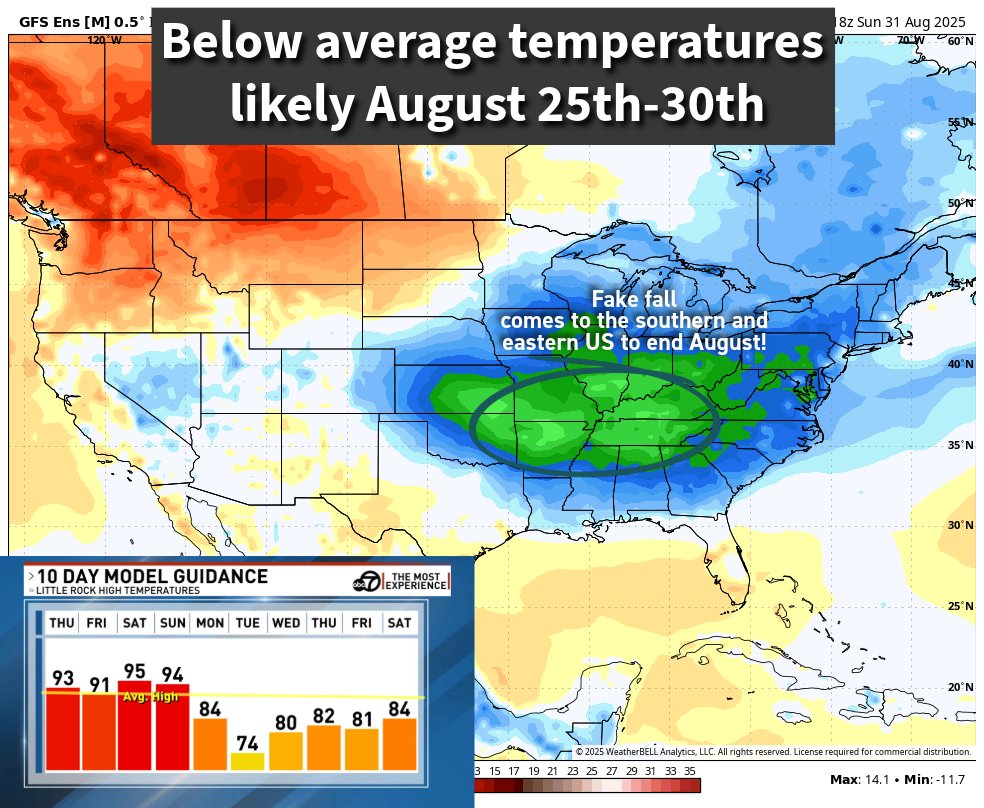
Next week is still looking REFRESHING with below normal temperatures. Model forecast showing morning temperatures in the low 60s and perhaps 50s 👀 #arwx

Next week is still looking REFRESHING with below normal temperatures.

Model forecast showing morning temperatures in the low 60s and perhaps 50s 👀 #arwx
Austin Burkes ⛈️ (@austinburkeswx) 's Twitter Profile Photo

We have some GOOD rain that will impact Arkansas this week. First round: Monday evening - Tuesday afternoon Second round: Late Thursday - early Friday Rainfall totals could be around 1-3” for central Arkansas with higher amounts across west/northwest Arkansas. Love to see

We have some GOOD rain that will impact Arkansas this week. 

First round: Monday evening - Tuesday afternoon 

Second round: Late Thursday - early Friday

Rainfall totals could be around 1-3” for central Arkansas with higher amounts across west/northwest Arkansas. Love to see
Austin Burkes ⛈️ (@austinburkeswx) 's Twitter Profile Photo

🌅 Sunset Warning 🌅 Beautiful sunset as we end our weekend here in central Arkansas. Even mother nature is excited about the cooler temperatures on the way! #arwx

🌅 Sunset Warning 🌅

Beautiful sunset as we end our weekend here in central Arkansas. Even mother nature is excited about the cooler temperatures on the way! #arwx
Austin Burkes ⛈️ (@austinburkeswx) 's Twitter Profile Photo

Monday Rain 🌧️ Showers will slowly move south across the state during the afternoon and evening. Look how temperatures will be impacted by the clouds and rain tomorrow. Near 90 in south Arkansas to the 60s north! #arwx

Monday Rain 🌧️

Showers will slowly move south across the state during the afternoon and evening. 

Look how temperatures will be impacted by the clouds and rain tomorrow. Near 90 in south Arkansas to the 60s north! #arwx
Austin Burkes ⛈️ (@austinburkeswx) 's Twitter Profile Photo

Heavy Rain Potential Thursday 🌧️ Rain arrives across central Arkansas Thursday morning and will stick around throughout the afternoon. An axis of heavier rain will set up somewhere in north-central Arkansas. This area could see 2-3”+ with the rest of us seeing around 1-2”.

Heavy Rain Potential Thursday 🌧️

Rain arrives across central Arkansas Thursday morning and will stick around throughout the afternoon. 

An axis of heavier rain will set up somewhere in north-central Arkansas. This area could see 2-3”+ with the rest of us seeing around 1-2”.