🇧🇿 Belize GEO 🛰️ (@bzgeo) 's Twitter Profile
🇧🇿 Belize GEO 🛰️

@bzgeo

Belize GEO: Belize Group on #EarthObservation & GIS. #SciComm re: EO, GIS relevant to #Belize, the #Caribbean. Administered by a real live Belizean scientist.

ID: 731808469301493760

linkhttp://www.bzgeo.net calendar_today15-05-2016 11:28:30

73,73K Tweet

9,9K Followers

7,7K Following

NASAEarthdata (@nasaearthdata) 's Twitter Profile Photo

NASA offers many tools to help you access and get the most out of NASA Earth observation data. But which tool is the right one for you and your objectives? This chart is designed to help you identify the correct tool for the data you need: earthdata.nasa.gov/data/tools/whi…

NASA offers many tools to help you access and get the most out of NASA Earth observation data. But which tool is the right one for you and your objectives? This chart is designed to help you identify the correct tool for the data you need: earthdata.nasa.gov/data/tools/whi…
ALDroughtReach (@aldroughtreach) 's Twitter Profile Photo

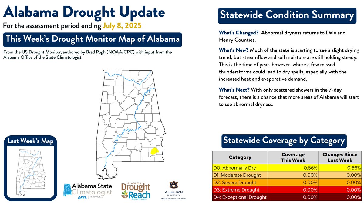
#AL Drought Update‼️ After a month of near-normal conditions, D0 Abnormal Dryness has returned to Dale & Henry Counties. Much of the state is actually starting to see a slight drying trend, but streamflow & soil moisture levels are still holding steady. #ALDroughtReach

#AL Drought Update‼️

After a month of near-normal conditions, D0 Abnormal Dryness has returned to Dale & Henry Counties. Much of the state is actually starting to see a slight drying trend, but streamflow & soil moisture levels are still holding steady. #ALDroughtReach
AerosolWatch (@aerosolwatch) 's Twitter Profile Photo

Wildfires in northern California & southern Oregon yesterday 9 Jul emitted localized smoke plumes that degraded daily PM2.5 air quality (purple, red & orange shading) in between sites of regulatory PM2.5 monitors (colored dots). Joint Polar Satellite System (JPSS) NOAA Satellites airnow

Wildfires in northern California &amp; southern Oregon yesterday 9 Jul emitted localized smoke plumes that degraded daily PM2.5 air quality (purple, red &amp; orange shading) in between sites of regulatory PM2.5 monitors (colored dots). <a href="/JPSSProgram/">Joint Polar Satellite System (JPSS)</a> <a href="/NOAASatellites/">NOAA Satellites</a> <a href="/AIRNow/">airnow</a>
CEOS (@ceosdotorg) 's Twitter Profile Photo

⏱️ 🚀 Catch up on CEOS activities with the latest edition of the CEOS Communications Quarterly Revisit! Read it here: mailchi.mp/0766e7ea8c73/r… Subscribe so you don't miss future issues: eepurl.com/ij_2z1

GFOI (@gfoi_forest) 's Twitter Profile Photo

📣 Plénière GFOI 2025 : lieu, dates et logistique ! 📍 Où : Grand Hyatt Bali à Nusa Dua & en ligne 📅 Quand : 21–23 octobre 2025 🔗 Plus d'informations : fao.org/gfoi/plenaries… ⚠️ L'inscription est obligatoire : forms.office.com/e/tk2Pgbmu3b #SuiviDesForêts #ActionClimatique

📣 Plénière GFOI 2025 : lieu, dates et logistique !

📍 Où : Grand Hyatt Bali à Nusa Dua &amp; en ligne
📅 Quand : 21–23 octobre 2025

🔗 Plus d'informations : fao.org/gfoi/plenaries…

⚠️ L'inscription est obligatoire : forms.office.com/e/tk2Pgbmu3b

#SuiviDesForêts #ActionClimatique
Qiusheng Wu (@giswqs) 's Twitter Profile Photo

🚀 New Feature Alert: Instance Segmentation with GeoAI! 🛰️🧠 The GeoAI Python package now supports instance segmentation for remote sensing imagery — all with just a few lines of code! You can quickly: ✅ Train instance segmentation models ✅ Run inference on multiple

🚀 New Feature Alert: Instance Segmentation with GeoAI! 🛰️🧠

The GeoAI Python package now supports instance segmentation for remote sensing imagery — all with just a few lines of code!

You can quickly:
✅ Train instance segmentation models
✅ Run inference on multiple
🇧🇿 Belize GEO 🛰️ (@bzgeo) 's Twitter Profile Photo

How I feel interacting with folks on LinkedIn who don't know my secret identity, and who are probably thinking, "Who are you again?" 🤷‍♂️😆 #GISchat #EOchat #GISbatman

UNEP Cartagena Convention & Caribbean Enviro Prog. (@unep_cep) 's Twitter Profile Photo

🎉 On this day in 1990, 🇻🇨 St. Vincent and the Grenadines ratified the Oil Spills Protocol under the #CartagenaConvention. With International Maritime Organization & REMPEITC-CARIBE support, SVG has: ✔️ Built oil spill response plans ✔️ Strengthened Coast Guard capacity ✔️ Joined regional response efforts


🎉 On this day in 1990, 🇻🇨 St. Vincent and the Grenadines ratified the Oil Spills Protocol under the #CartagenaConvention. With <a href="/IMOHQ/">International Maritime Organization</a> &amp; REMPEITC-CARIBE support, SVG has:
✔️ Built oil spill response plans
✔️ Strengthened Coast Guard capacity
✔️ Joined regional response efforts

AerosolWatch (@aerosolwatch) 's Twitter Profile Photo

Thick smoke (orange/yellow/teal shading) is streaming southward from the Green Fire and Orleans Complex wildfires in northern California today 11 Jul, shown by aerosol optical depth (AOD) from the ABI sensor on NOAA Satellites GOES-West. CAL FIRE

NASA SCoPE (@nasa_scope) 's Twitter Profile Photo

Explaining scientific findings can be difficult. Here are 10 helpful tips for explaining your research! 💡💡 #SciCommFridays Read more at: graduate.northeastern.edu/knowledge-hub/…

Explaining scientific findings can be difficult. Here are 10 helpful tips for explaining your research! 💡💡 #SciCommFridays

Read more at: graduate.northeastern.edu/knowledge-hub/…
🇧🇿 Belize GEO 🛰️ (@bzgeo) 's Twitter Profile Photo

[I love Google and all but] I was #TodayOld when I realized that I [and my coworkers] should have been doing knowledge management using @GitHub repos instead of Google sites and Google Docs. Years lost... Oh well... 🤷‍♂️

ML Earth Sciences (@mlearthsciences) 's Twitter Profile Photo

Researchers from IISER Bhopal have developed a promising framework for forest fire prediction using ML. 🔥🌲 It supports evidence-based decision-making and helps policy makers design targeted fire prevention strategies. 👏 Applause to the team addressing this vital issue! #ML

NASA JPL (@nasajpl) 's Twitter Profile Photo

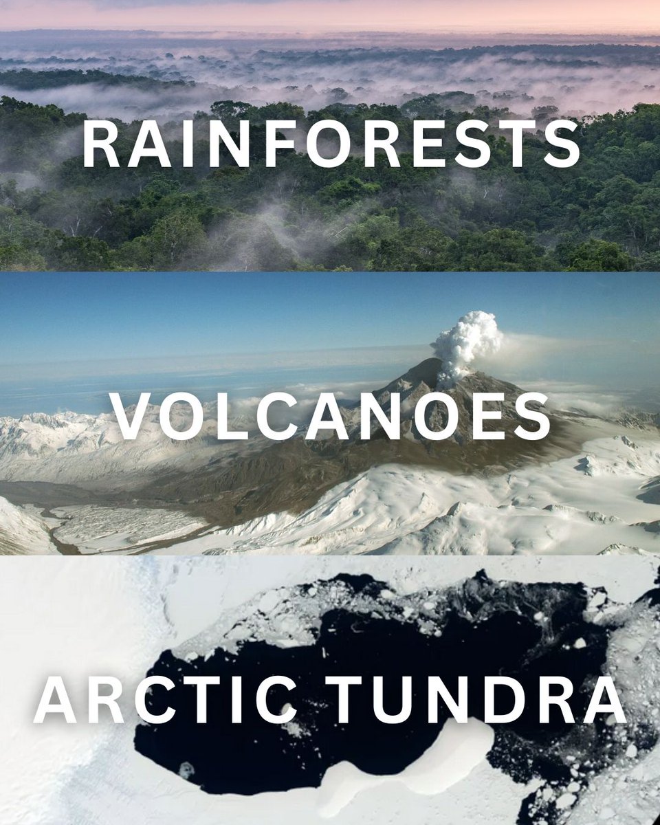
Rainforests. Volcanoes. Arctic tundra. 🌍 From wildfire damage and volcanic eruptions to forest regrowth, NISAR will reveal how our planet's surface is changing in even the smallest ways. The Earth-observing mission is set to launch soon: nisar.jpl.nasa.gov

Rainforests. Volcanoes. Arctic tundra. 🌍

From wildfire damage and volcanic eruptions to forest regrowth, NISAR will reveal how our planet's surface is changing in even the smallest ways.

The Earth-observing mission is set to launch soon: nisar.jpl.nasa.gov
ALDroughtReach (@aldroughtreach) 's Twitter Profile Photo

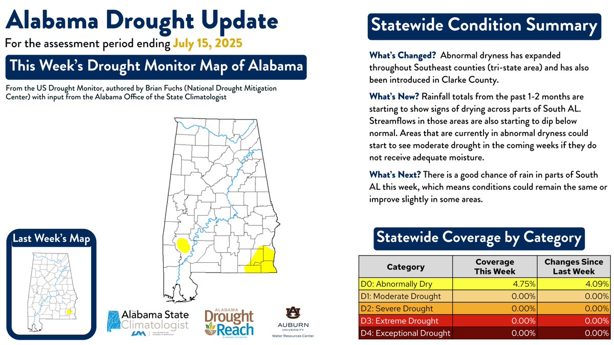
#AL Drought Update‼️ Abnormal dryness expanded in the tri-state area & in Clarke Co. South AL is drying out, with low rain & declining streamflows. Moderate drought could develop in the coming weeks, but a wet forecast over the next 5 days may bring some relief. #ALDroughtReach

#AL Drought Update‼️

Abnormal dryness expanded in the tri-state area &amp; in Clarke Co. South AL is drying out, with low rain &amp; declining streamflows. Moderate drought could develop in the coming weeks, but a wet forecast over the next 5 days may bring some relief. #ALDroughtReach
NASA JPL (@nasajpl) 's Twitter Profile Photo

NISAR is preparing for launch 🚀 On Monday, July 21, NASA and NISAR project leadership will preview this upcoming NASA-@ISRO mission, which will use powerful radar to study Earth's land and ice surfaces. Tune in at 9am PT/12pm ET: youtube.com/live/sLjvAmK_s…

Qiusheng Wu (@giswqs) 's Twitter Profile Photo

🚀 Sneak Peek: Interactive Visualization of the Planet Tanager Hyperspectral Data (planet.com/data/stac/brow…) Using the HyperCoast Python package Stay tuned for notebook examples and video tutorials. GitHub: github.com/opengeos/Hyper… #geospatial #Tanager #Python #DataScience

Abhilash Singh (@abhilash_iiserb) 's Twitter Profile Photo

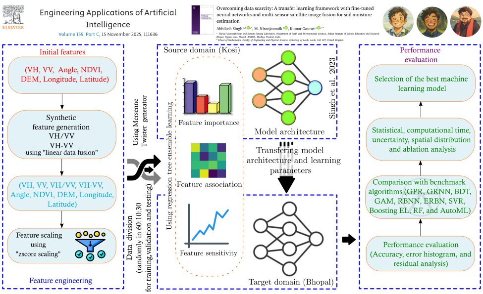
Happy to share our new paper is out in Engineering Applications of AI! "Overcoming Data Scarcity" uses transfer learning + satellite fusion to predict soil moisture with 55% less in-situ data 🔗 doi.org/10.1016/j.enga… 📂 abhilashsingh.net/codes.html #RemoteSensing #ML #AI

Happy to share our new paper is out in Engineering Applications of AI!
 "Overcoming Data Scarcity" uses transfer learning + satellite fusion to predict soil moisture with 55% less in-situ data
🔗 doi.org/10.1016/j.enga…
📂 abhilashsingh.net/codes.html
#RemoteSensing #ML #AI