California Geological Survey (@cageosurvey) 's Twitter Profile
California Geological Survey

@cageosurvey

Info about the Golden State’s earthquakes, geology, & minerals from scientists at the California Geological Survey (CGS), a division of @CalConservation

ID: 1425536677938749440

linkhttp://www.conservation.ca.gov/cgs calendar_today11-08-2021 19:17:29

1,1K Tweet

6,6K Followers

210 Following

California Department of Conservation (@calconservation) 's Twitter Profile Photo

Join our legislative team in Sacramento as a Legislative Analyst. Track legislation, draft policy materials, & contribute to shaping California’s natural resource priorities. A great opportunity for strong writers with an interest in state government. 🫵calcareers.ca.gov/CalHrPublic/Jo…

Governor Gavin Newsom (@cagovernor) 's Twitter Profile Photo

A tsunami warning is now in effect along parts of California’s North Coast — from Cape Mendocino to the Oregon border. California Governor's Office of Emergency Services is coordinating with local officials. Please stay alert and follow instructions from emergency personnel.

California Geological Survey (@cageosurvey) 's Twitter Profile Photo

The California Geological Survey is gathering observations about the tsunami generated by the M8.8 Kamchatka earthquake. If you are in CA and made any first-hand observations of the tsunami or the evidence left behind by the tsunami please fill out this survey. survey123.arcgis.com/share/76979db3…


USGS Earthquakes (@usgs_quakes) 's Twitter Profile Photo

A magnitude 8.8 earthquake struck of Russia's Kamchatka Peninsula on July 29, 2025 (July 30 local time). USGS scientists modeled the rupture of this historic earthquake tied for the sixth-largest earthquake ever recorded by modern seismic instruments. Check out the visualization

California Governor's Office of Emergency Services (@cal_oes) 's Twitter Profile Photo

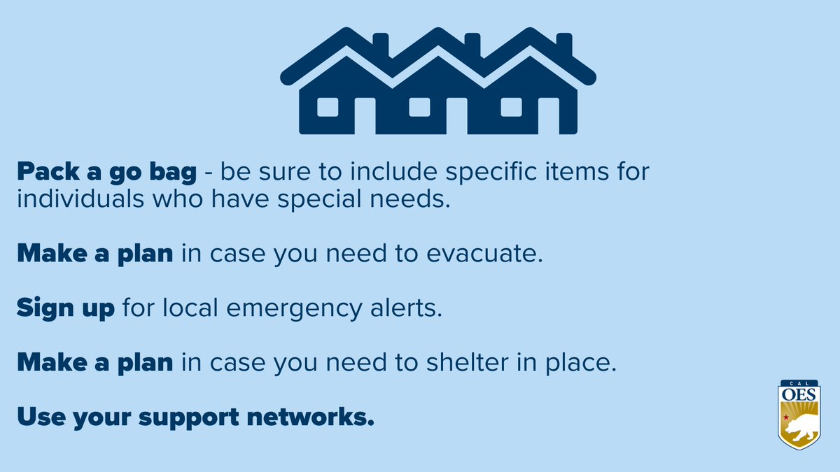
Emergencies can happen anytime. Having a personalized emergency plan helps keep you and your loved ones safe. ✅ Sign up for local alerts ✅ Make an evacuation plan with meeting spots ✅ Pack a go-bag for yourself and your loved ones (including your pets!) Learn more at

Emergencies can happen anytime. Having a personalized emergency plan helps keep you and your loved ones safe.
✅ Sign up for local alerts
✅ Make an evacuation plan with meeting spots
✅ Pack a go-bag for yourself and your loved ones (including your pets!)
Learn more at
California Governor's Office of Emergency Services (@cal_oes) 's Twitter Profile Photo

THIS WEEK: Governor Gavin Newsom directed California Governor's Office of Emergency Services to preposition firefighting resources in Southern CA for critical fire weather conditions. With extreme heat this weekend, drink plenty of water and take frequent rest breaks when working outside.

California Geological Survey (@cageosurvey) 's Twitter Profile Photo

We’re hiring an Engineering Geologist (Staff Seismologist) to support seismic data systems, analyze earthquake strong-motion records, & advance California’s Earthquake Early Warning network. calcareers.ca.gov/CalHrPublic/Jo… 📍Sacramento Apply by: 9/2/25 California Natural Resources Agency California Department of Conservation

California Governor's Office of Emergency Services (@cal_oes) 's Twitter Profile Photo

It’s important to know the difference between an Evacuation Warning and Evacuation Order, especially during critical fire weather. Watch the video ⬇️ to learn more.

Readygov (@readygov) 's Twitter Profile Photo

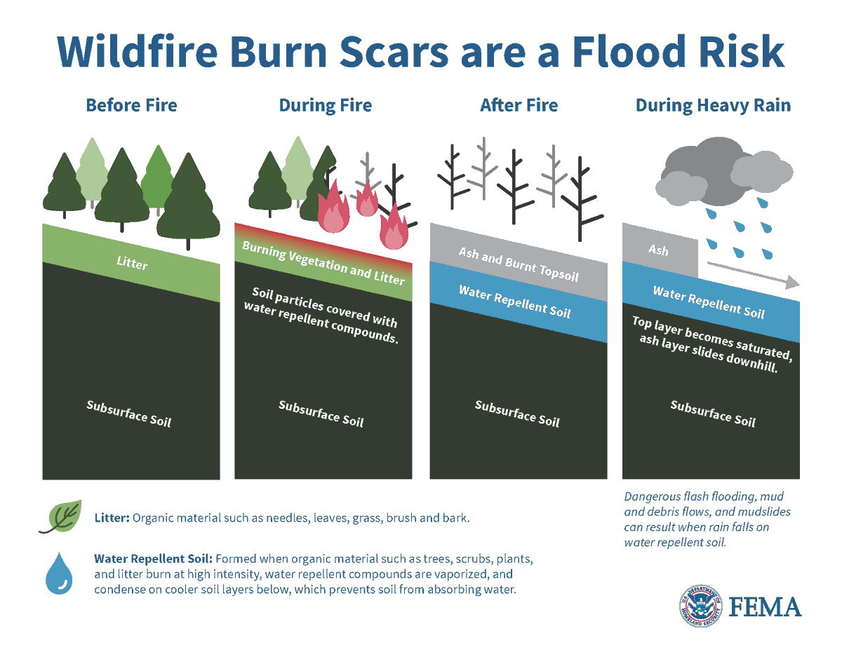
After a wildfire, burned soil can repel water. As a result, less rainfall is required for flash flooding in areas where wildfires have recently burned. If you live in one of these areas, and heavy rain is in the forecast, plan in advance and move away from the area.

After a wildfire, burned soil can repel water. As a result, less rainfall is required for flash flooding in areas where wildfires have recently burned.

If you live in one of these areas, and heavy rain is in the forecast, plan in advance and move away from the area.
SGC | CA Strategic Growth Council (@calsgc) 's Twitter Profile Photo

📢 Our Sustainable Agricultural Land Conservation program (SALC) is #hiring! 🌱Do you have a passion for leading innovative ways to conserve energy, land, and mineral resources? Then consider joining the SALC team as the new Senior Environmental Planner! 🐄This position is

California Department of Conservation (@calconservation) 's Twitter Profile Photo
After a tsunami advisory is lifted, geologists are on the frontlines studying the aftermath. CalConservation Dir. Lucchesi joined State Geologist Lancaster & California Geological Survey in Eureka, gathering evidence from the July 29 CA tsunami to build maps & tools that help communities prepare


After a tsunami advisory is lifted, geologists are on the frontlines studying the aftermath. CalConservation Dir. Lucchesi joined State Geologist Lancaster &amp; <a href="/CAGeoSurvey/">California Geological Survey</a> in Eureka, gathering evidence from the July 29 CA tsunami to build maps &amp; tools that help communities prepare
WA Emergency Management (@waemd) 's Twitter Profile Photo

It’s the start of National Preparedness Month! It's a good time to remind you that emergencies and disasters happen every day – but there are things you can do to protect yourself, your family and your home. Learn more at mil.wa.gov/preparedness

It’s the start of National Preparedness Month! It's a good time to remind you that emergencies and disasters happen every day – but there are things you can do to protect yourself, your family and your home.  Learn more at mil.wa.gov/preparedness
California Governor's Office of Emergency Services (@cal_oes) 's Twitter Profile Photo

September is National Preparedness Month. Make sure your family is ready with a go bag packed with essentials. Not sure what to include? Go to wp.me/pgM8my-8CN for a list of items.

Readygov (@readygov) 's Twitter Profile Photo

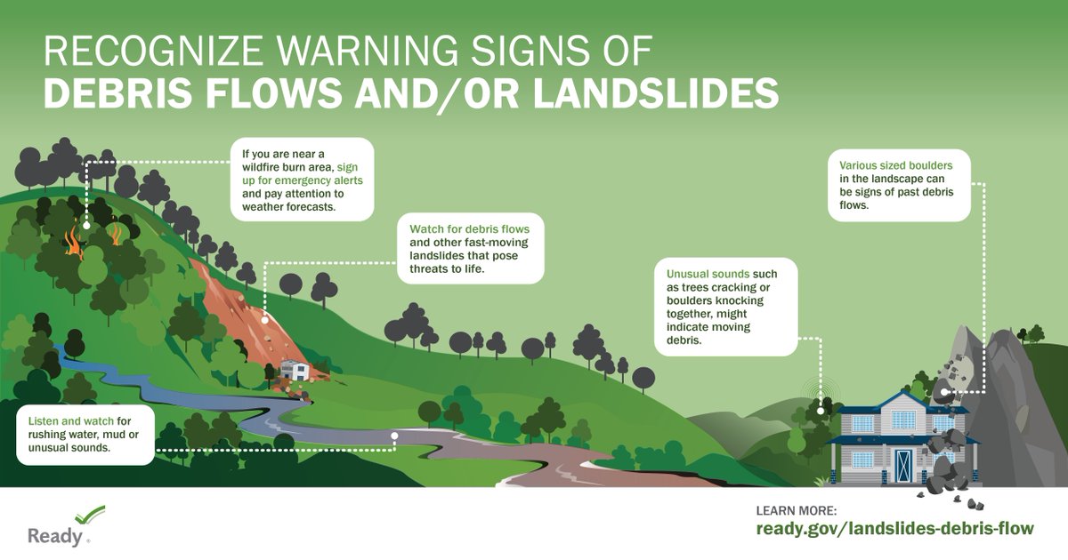
After a wildfire, the risk of landslides is increased. Know how to spot the signs of a landslide and be ready ➡️ ready.gov/landslides-deb…

After a wildfire, the risk of landslides is increased. Know how to spot the signs of a landslide and be ready ➡️ ready.gov/landslides-deb…
California Governor's Office of Emergency Services (@cal_oes) 's Twitter Profile Photo

Parts of Northern California will be under Red Flag Warnings through much of Tuesday into Wednesday morning. Find resources and get prepared for wildfire at ready.ca.gov. Stay informed with National Weather Service at weather.gov Listen to local authorities if told to

Parts of Northern California will be under Red Flag Warnings through much of Tuesday into Wednesday morning.

Find resources and get prepared for wildfire at ready.ca.gov.

Stay informed with <a href="/NWS/">National Weather Service</a> at weather.gov

Listen to local authorities if told to
California Geological Survey (@cageosurvey) 's Twitter Profile Photo

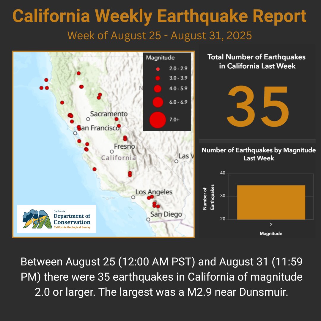
California Weekly Earthquake Report Between August 25 (12:00 AM PST) and August 31 (11:59 PM PST) there were 35 earthquakes in California of magnitude 2.0 or larger. The largest was a magnitude 2.9 near Dunsmuir, CA. cadoc.maps.arcgis.com/apps/dashboard…

California Weekly Earthquake Report

Between August 25 (12:00 AM PST) and August 31 (11:59 PM PST) there were 35 earthquakes in California of magnitude 2.0 or larger. The largest was a magnitude 2.9 near Dunsmuir, CA. 

cadoc.maps.arcgis.com/apps/dashboard…
California Geological Survey (@cageosurvey) 's Twitter Profile Photo

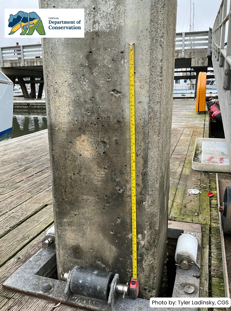
The July 29 M8.8 Kamchatka Peninsula #earthquake triggered a #tsunami advisory along CA’s coast. #CaGeoSurvey scientists surveyed sites, incl. Pillar Point Harbor, where watermarks showed surges raising/lowering boat ramps overnight. Data improves hazard models, maps & planning.

The July 29 M8.8 Kamchatka Peninsula #earthquake triggered a #tsunami advisory along CA’s coast. #CaGeoSurvey scientists surveyed sites, incl. Pillar Point Harbor, where watermarks showed surges raising/lowering boat ramps overnight. Data improves hazard models, maps &amp; planning.