ESA Earth Online (@esa_earthonline) 's Twitter Profile
ESA Earth Online

@esa_earthonline

Stay updated with #EarthOnline with #ESA and #TPM #EarthObservation missions, data, and satellite instruments 🛰️🌍

ID: 718030614

linkhttps://earth.esa.int calendar_today26-07-2012 12:37:25

3,3K Tweet

2,2K Followers

419 Following

ESA Earth Online (@esa_earthonline) 's Twitter Profile Photo

🌍 Today, 23 May 2025, we celebrate World Turtle Day! 🐢 To mark the occasion, here's a striking SAR view of the Galápagos Islands, captured by ICEYE's Synthetic Aperture Radar (SAR) 🛰️. Discover how ICEYE SAR supports vital Earth observation applications: 🌾 Agricultural

🌍 Today, 23 May 2025, we celebrate World Turtle Day! 🐢
To mark the occasion, here's a striking SAR view of the Galápagos Islands, captured by ICEYE's Synthetic Aperture Radar (SAR) 🛰️.
Discover how ICEYE SAR supports vital Earth observation applications:
🌾 Agricultural
ESA Earth Online (@esa_earthonline) 's Twitter Profile Photo

⚽ Today, 25 May, we celebrate World Football Day! Check out this stunning view of Rome’s iconic Stadio Olimpico, captured by Pléiades 🛰️. 📡 The Pléiades ESA archive features imagery from Pléiades-1A & 1B, continuously expanded with new data collected by European Space Agency. Available
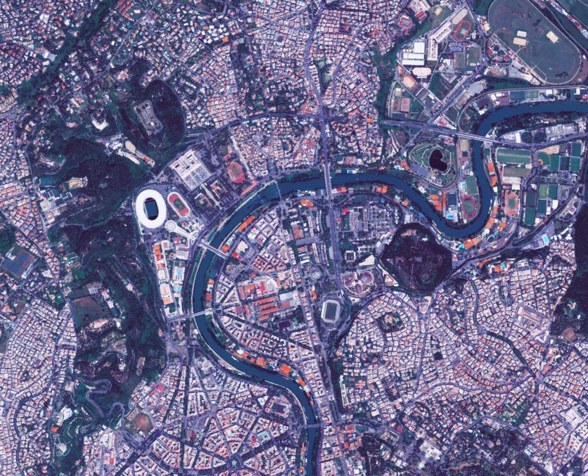
⚽ Today, 25 May, we celebrate World Football Day!
Check out this stunning view of Rome’s iconic Stadio Olimpico, captured by Pléiades 🛰️.
📡 The Pléiades ESA archive features imagery from Pléiades-1A &amp; 1B, continuously expanded with new data collected by <a href="/esa/">European Space Agency</a>.

Available
ESA Earth Online (@esa_earthonline) 's Twitter Profile Photo

🌍 A glimpse of KOMPSAT-2 over Borneo The Sandakan Peninsula in Sabah, Malaysia, shows a dramatic transformation: much of the original forest 🌲 has been cleared for agriculture 🌱—from crop fields and plantations to timber cultivation. This land use change is visible in the RGB

🌍 A glimpse of KOMPSAT-2 over Borneo

The Sandakan Peninsula in Sabah, Malaysia, shows a dramatic transformation: much of the original forest 🌲 has been cleared for agriculture 🌱—from crop fields and plantations to timber cultivation. This land use change is visible in the RGB
ESA Earth Online (@esa_earthonline) 's Twitter Profile Photo

🏙️ TerraSAR-X (Radar, VHR) enables robust, large-scale urban flood mapping using single SAR acquisitions—no reference (non-flood) images needed. A powerful way to tap into existing data archives for flood impact assessment. 📅 Temporal coverage: 2007-07-01 - present 🔍

🏙️ TerraSAR-X (Radar, VHR) enables robust, large-scale urban flood mapping using single SAR acquisitions—no reference (non-flood) images needed. A powerful way to tap into existing data archives for flood impact assessment.

📅 Temporal coverage: 2007-07-01 - present
🔍
ESA Earth Online (@esa_earthonline) 's Twitter Profile Photo

🚀 A sharp look at the Arctic! In 2023, PAZ snapped this stunning view of Spitsbergen 🇳🇴 — the largest island in the 🌍 Svalbard Archipelago. Bright spot? That’s Longyearbyen on the shore of Adventfjorden. 🛰️ Orbiting with its twins TerraSAR-X & TanDEMX, PAZ offers identical

🚀 A sharp look at the Arctic!

In 2023, PAZ snapped this stunning view of Spitsbergen 🇳🇴 — the largest island in the 🌍 Svalbard Archipelago.
Bright spot? That’s Longyearbyen on the shore of Adventfjorden.

🛰️ Orbiting with its twins TerraSAR-X &amp; TanDEMX, PAZ offers identical
ESA Earth Online (@esa_earthonline) 's Twitter Profile Photo

💫Rivers on the move! Captured by WorldView-2, the Queets (top) & Sams (bottom) Rivers snake through Washington State 🇺🇸 near the Canadian 🇨🇦 border — with Vancouver just to the north. Thanks to its high discharge and abundant woody 🪵 debris, the Queets River is prone to log

💫Rivers on the move!

Captured by WorldView-2, the Queets (top) &amp; Sams (bottom) Rivers snake through Washington State 🇺🇸 near the Canadian 🇨🇦 border — with Vancouver just to the north.

Thanks to its high discharge and abundant woody 🪵 debris, the Queets River is prone to log
ESA Earth Online (@esa_earthonline) 's Twitter Profile Photo

🌎 Winding through the Peruvian Amazon, the sinuous Ucayali River — a major Amazon tributary — is captured in this stunning @MDA Radarsat-2 image from Sept 2011. Spot the bright patch? That’s Pucallpa, capital of the Ucayali region. The scene is dominated by dense rainforest,

🌎 Winding through the Peruvian Amazon, the sinuous Ucayali River — a major Amazon tributary — is captured in this stunning @MDA Radarsat-2 image from Sept 2011. Spot the bright patch? That’s Pucallpa, capital of the Ucayali region.

The scene is dominated by dense rainforest,
ESA Earth Online (@esa_earthonline) 's Twitter Profile Photo

Did you know? @ESA’s Fundamental Data Records (FDR) framework enhances datasets from Heritage missions, such as ERS & Envisat, boosting their value for long-term studies like climate change 🌍📈 earth.esa.int/eogateway/info…

ESA Earth Online (@esa_earthonline) 's Twitter Profile Photo

🎉 One year of @ESA & JAXA(Japan Aerospace Exploration Agency)’s EarthCARE in orbit! Launched on 29 May 2024, this advanced Earth Explorer is shedding new light on clouds, aerosols, and radiation. 🛰️🌍 From falling snow to polar clouds—and even insects and phytoplankton! earth.esa.int/eogateway/succ…

ESA Earth Online (@esa_earthonline) 's Twitter Profile Photo

A glimpse of Tbilisi 🇬🇪, Georgia’s capital, as seen from space! Captured by @Kari2030’s Kompsat-1 in Sept 2001, the River Kura winds through the city, with the Tbilisi Reservoir clearly visible to the north. This image is part of a unique @ESA Heritage Mission dataset: Kompsat-1

A glimpse of Tbilisi 🇬🇪, Georgia’s capital, as seen from space! Captured by @Kari2030’s Kompsat-1 in Sept 2001, the River Kura winds through the city, with the Tbilisi Reservoir clearly visible to the north.

This image is part of a unique @ESA Heritage Mission dataset: Kompsat-1
ESA Earth Online (@esa_earthonline) 's Twitter Profile Photo

🛰️ HotSat-1 provided high-resolution thermal infrared imagery of Earth, with frequent revisits that enabled near-daily data collection. Its data supported 🌍 industrial monitoring, 🌡️ energy loss detection, and 🌱 environmental & energy management. 📢 The AO Call for HotSat-1

🛰️ HotSat-1 provided high-resolution thermal infrared imagery of Earth, with frequent revisits that enabled near-daily data collection.

Its data supported 🌍 industrial monitoring, 🌡️ energy loss detection, and 🌱 environmental &amp; energy management.

📢 The AO Call for HotSat-1
ESA Earth Online (@esa_earthonline) 's Twitter Profile Photo

Share your experience! Help improve access to ESA’s EO data, tools, and web info – take our 5-minute survey lps2025.survey.esaportal.eu Your feedback will support better services for the EO science community. 👇

ESA Earth Online (@esa_earthonline) 's Twitter Profile Photo

🛰️ Pleiades, successor to the 🔍 SPOT programme, brings cutting-edge tech, high-res imaging & daily global coverage — all with cost-effective, user-friendly access. Equipped with the HiRI sensor, it supports: ✅ Cartography ✅ Agriculture ✅ Forestry ✅ Geology ✅ Risk

🛰️ Pleiades, successor to the 🔍 SPOT programme, brings cutting-edge tech, high-res imaging &amp; daily global coverage — all with cost-effective, user-friendly access.

Equipped with the HiRI sensor, it supports:
✅ Cartography
✅ Agriculture
✅ Forestry
✅ Geology
✅ Risk
ESA Earth Online (@esa_earthonline) 's Twitter Profile Photo

💧 Nestled in the karst landscape of Inner Carniola, SW Slovenia, Lake Cerknica (Cerkniško Jezero) is a remarkable intermittent lake — filling seasonally, then partially or fully vanishing as waters drain through underground sinkholes or evaporate. 🛰️ This Pléiades Neo image

💧 Nestled in the karst landscape of Inner Carniola, SW Slovenia, Lake Cerknica (Cerkniško Jezero) is a remarkable intermittent lake — filling seasonally, then partially or fully vanishing as waters drain through underground sinkholes or evaporate.

🛰️ This Pléiades Neo image
ESA Earth Online (@esa_earthonline) 's Twitter Profile Photo

🛰️ Captured by ALOS’ PRISM sensor, this high-res stereo image shows SW Madagascar, where the Fiheranana River (right) meets the coastline. The PRISM sensor used a panchromatic pushbroom scanner across 0.52–0.77 µm, delivering 2.5 m resolution. 🗺️ In stereo: 35 km swath | Nadir:

🛰️ Captured by ALOS’ PRISM sensor, this high-res stereo image shows SW Madagascar, where the Fiheranana River (right) meets the coastline. The PRISM sensor used a panchromatic pushbroom scanner across 0.52–0.77 µm, delivering 2.5 m resolution.

🗺️ In stereo: 35 km swath | Nadir:
ESA Earth Online (@esa_earthonline) 's Twitter Profile Photo

🛰️ Captured by ALOS PRISM (Panchromatic Remote-sensing Instrument for Stereo Mapping), this VHR image shows the northeastern Gulf of Finland. In the upper-right: 🏙️ Hamina (north) 🏙️ Kotka (SW, at the mouth of the Kymi River) Together, their ports form the Port of Hamina-Kotka —

🛰️ Captured by ALOS PRISM (Panchromatic Remote-sensing Instrument for Stereo Mapping), this VHR image shows the northeastern Gulf of Finland.

In the upper-right:
🏙️ Hamina (north)
🏙️ Kotka (SW, at the mouth of the Kymi River)
Together, their ports form the Port of Hamina-Kotka —