Ethan Rosuck (@ethanrosuckwx) 's Twitter Profile
Ethan Rosuck

@ethanrosuckwx

Meteorologist @FOX59 @CBS4Indy β›ˆοΈπŸŒͺ️❄️ | Formerly: @WIFRTV | Ball State @BSUGeography & @BallStateMedia Alum | North Chicago Suburbs = 🏠

ID: 920078682

calendar_today02-11-2012 00:23:11

7,7K Tweet

1,1K Followers

1,1K Following

Brian Wilkes (@brianwilkes59wx) 's Twitter Profile Photo

26 states had at least one location report a 100Β° temperature Tuesday. Hottest, 119Β° at Stovepipe Wells, CA (Death Valley) #Summer #INwx #DiFax

26 states had at least one location report a 100Β° temperature Tuesday. Hottest, 119Β° at Stovepipe Wells, CA (Death Valley) #Summer #INwx #DiFax
Ethan Rosuck (@ethanrosuckwx) 's Twitter Profile Photo

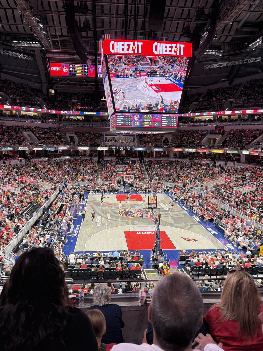
Normally I’m not off Wednesdays! So I get tot take advantage of midday Wednesday basketball! And Caitlin Clark is back πŸ‘πŸ»πŸ‘πŸ»πŸ€πŸ€ Indiana Fever

Normally I’m not off Wednesdays! So I get tot take advantage of midday Wednesday basketball! And <a href="/CaitlinClark22/">Caitlin Clark</a> is back πŸ‘πŸ»πŸ‘πŸ»πŸ€πŸ€

<a href="/IndianaFever/">Indiana Fever</a>
Ethan Rosuck (@ethanrosuckwx) 's Twitter Profile Photo

Yesterday marked the 27th day with above-normal temperatures since June 1st. Highs today will be a bit above normal in the upper 80s to near 90Β°. Some decent news is that it will NOT be as humid again. Keep an eye on the sky for a pop-up shower this afternoon. #INwx FOX59 News β˜€οΈ β›ˆοΈ

Yesterday marked the 27th day with above-normal temperatures since June 1st. Highs today will be a bit above normal in the upper 80s to near 90Β°. Some decent news is that it will NOT be as humid again. Keep an eye on the sky for a pop-up shower this afternoon. #INwx <a href="/FOX59/">FOX59 News</a> β˜€οΈ β›ˆοΈ
Ethan Rosuck (@ethanrosuckwx) 's Twitter Profile Photo

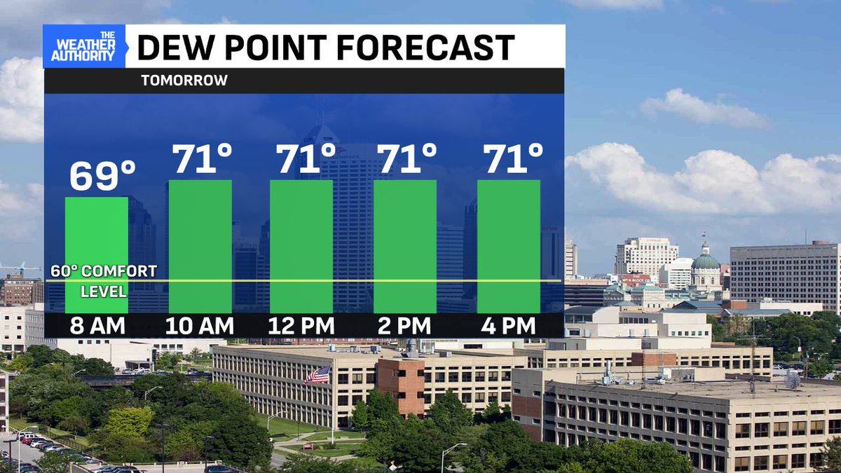
You can "feel" the air outside across Central IN. However, it's definitely NOT as humid compared to recent days. Many hometowns are seeing humidity levels a bit lower than 24 hours ago. Humidity levels go up Friday and Saturday with more widespread 70Β°+ dew points. #INwx FOX59 News

You can "feel" the air outside across Central IN. However, it's definitely NOT as humid compared to recent days. Many hometowns are seeing humidity levels a bit lower than 24 hours ago. Humidity levels go up Friday and Saturday with more widespread 70Β°+ dew points. #INwx <a href="/FOX59/">FOX59 News</a>
Ethan Rosuck (@ethanrosuckwx) 's Twitter Profile Photo

Heat Index values go UP tomorrow. Most spots will likely see mid-to-upper 90Β° values. Hot and humid conditions to persist into the weekend, too. #INwx FOX59 News

Heat Index values go UP tomorrow. Most spots will likely see mid-to-upper 90Β° values. Hot and humid conditions to persist into the weekend, too. #INwx <a href="/FOX59/">FOX59 News</a>
Ethan Rosuck (@ethanrosuckwx) 's Twitter Profile Photo

BUCK MOON πŸŒ•TONIGHT: Look SE during the moonrise tonight for the month's full moon! Known as a Buck Moon, it's named for the time when deer antlers begin regrowing. It will be low on the horizon due to the lunar standstill. Read more here: buff.ly/N0PvXA3

BUCK MOON πŸŒ•TONIGHT: Look SE during the moonrise tonight for the month's full moon! Known as a Buck Moon, it's named for the time when deer antlers begin regrowing. It will be low on the horizon due to the lunar standstill. Read more here: buff.ly/N0PvXA3
Brian Wilkes (@brianwilkes59wx) 's Twitter Profile Photo

The added humidity elevated the HEAT INDEX to the middle 90s late day. Peak heat index 95Β° Friday marks the 9th this summer with a heat index 95Β° or higher. #INwx

The added humidity elevated the HEAT INDEX to the middle 90s late day. Peak heat index 95Β° Friday marks the 9th this summer with a heat index 95Β° or higher. #INwx
Ethan Rosuck (@ethanrosuckwx) 's Twitter Profile Photo

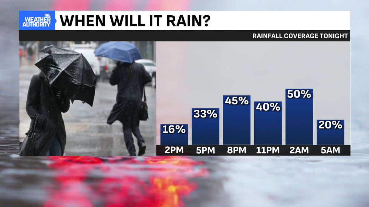
Next COLD FRONT brings rain ahead of its passage with the peak heating of the day Saturday. Scattered and possible gusty storms arrive with peak coverage (45%) before 5:00 pm. Not everyone sees rain but keep an eye out if you have outdoor plans during this time! #INwx FOX59 News
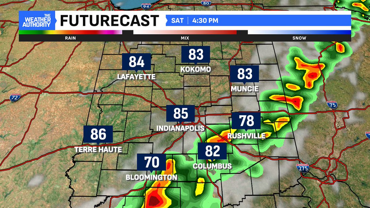
Next COLD FRONT brings rain ahead of its passage with the peak heating of the day Saturday. Scattered and possible gusty storms arrive with peak coverage (45%) before 5:00 pm. Not everyone sees rain but keep an eye out if you have outdoor plans during this time! #INwx <a href="/FOX59/">FOX59 News</a>
Ethan Rosuck (@ethanrosuckwx) 's Twitter Profile Photo

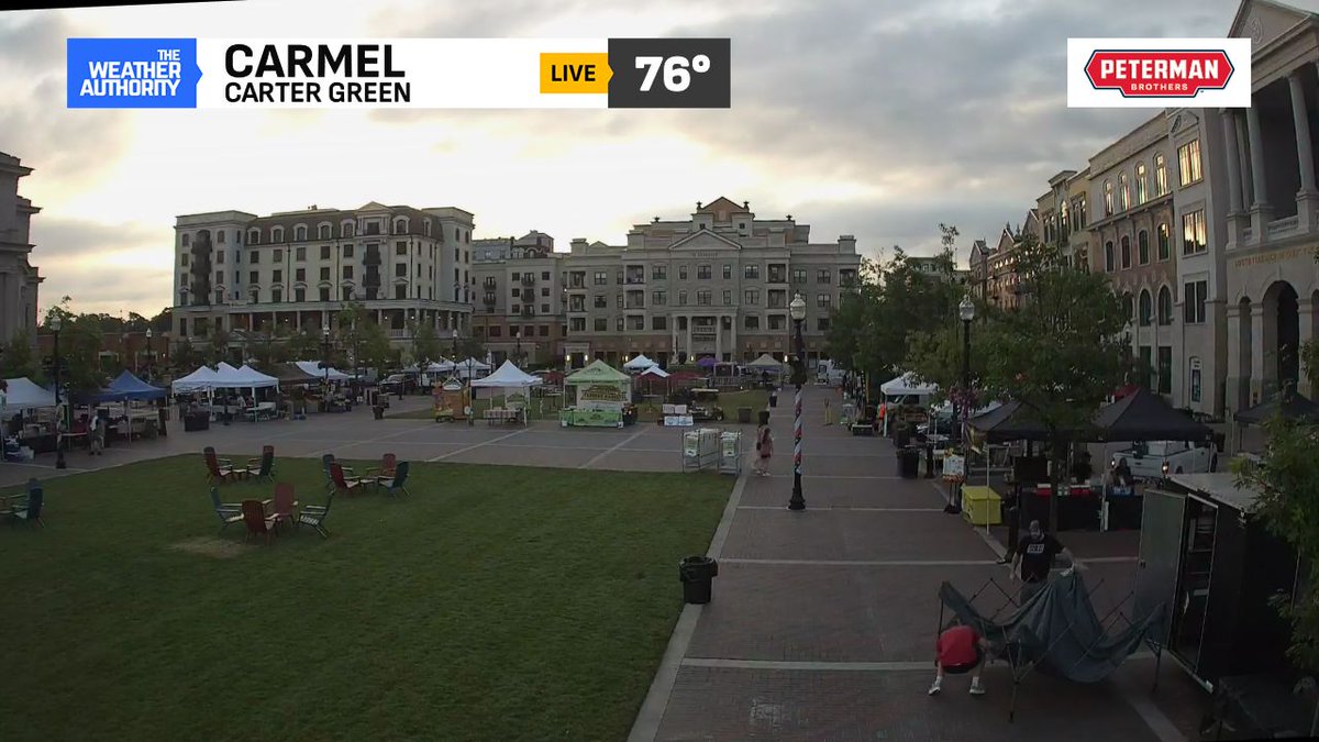
Good Saturday morning! Set up underway for the Carmel Farmers Mrkt kicking off at 8:00 AM. No issues to start the day minus the humidity already making itself known. We're tracking showers and storms ahead of a cold front. We're LIVE on FOX59 News with the timing. #INwx β›ˆοΈ

Good Saturday morning! Set up underway for the <a href="/CarmelFarmMrkt/">Carmel Farmers Mrkt</a> kicking off at 8:00 AM. No issues to start the day minus the humidity already making itself known. We're tracking showers and storms ahead of a cold front. We're LIVE on <a href="/FOX59/">FOX59 News</a> with the timing. #INwx β›ˆοΈ
Ethan Rosuck (@ethanrosuckwx) 's Twitter Profile Photo

Another HOT and HUMID Saturday ahead. Several spots will see heat indices near 100Β° before showers/storms arrive. Timing 3-9 PM from west to east. Some storms will be on the stronger side with downpours, lightning & higher wind gusts possible. Stay aware later today! #INwx FOX59 News
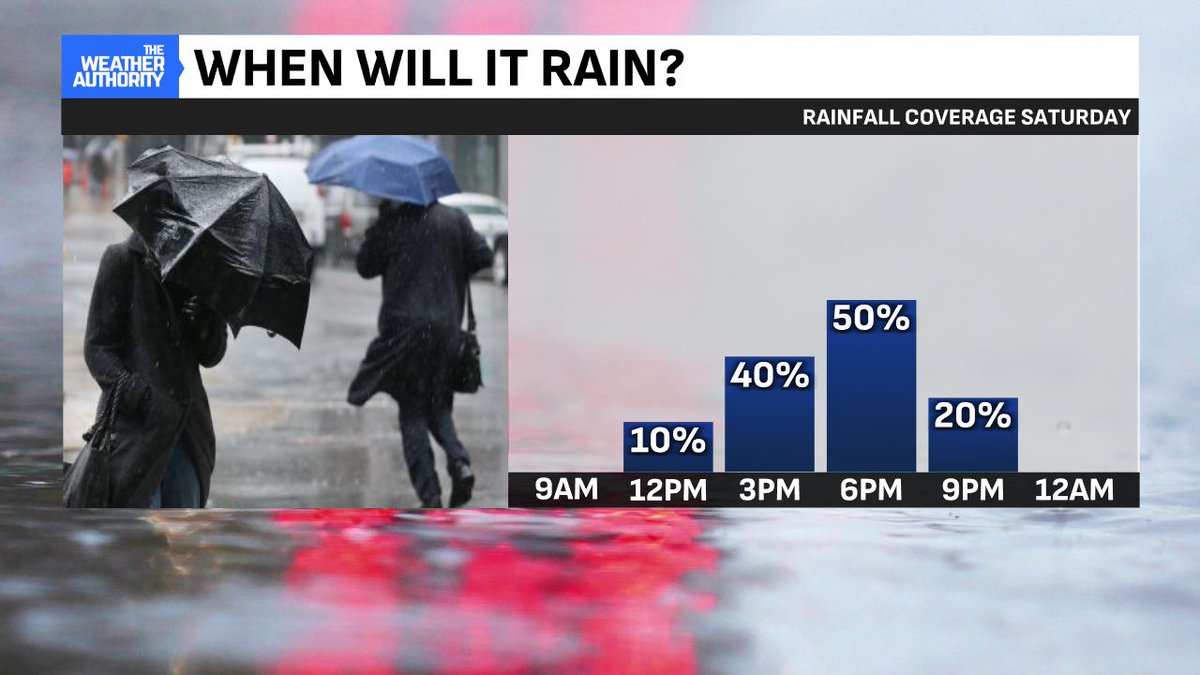
Another HOT and HUMID Saturday ahead. Several spots will see heat indices near 100Β° before showers/storms arrive. Timing 3-9 PM from west to east. Some storms will be on the stronger side with downpours, lightning &amp; higher wind gusts possible. Stay aware later today! #INwx <a href="/FOX59/">FOX59 News</a>
Ethan Rosuck (@ethanrosuckwx) 's Twitter Profile Photo

Timing for the storms begins at 3 PM in western Indiana. Closer to 5-6 PM for the #Indianapolis metro. Slightly higher threat for stronger storms (iso. damaging winds) exists along and east of I-69. #INwx FOX59 News
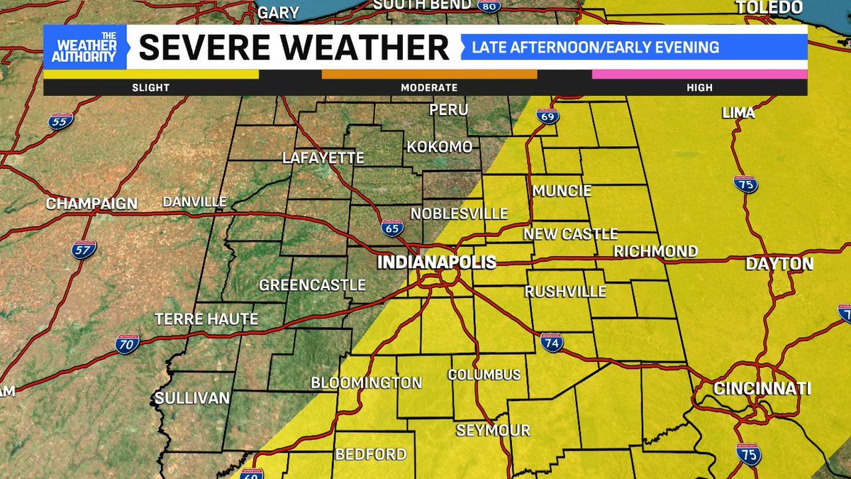
Timing for the storms begins at 3 PM in western Indiana. Closer to 5-6 PM for the #Indianapolis metro. Slightly higher threat for stronger storms (iso. damaging winds) exists along and east of I-69. #INwx <a href="/FOX59/">FOX59 News</a>
Ethan Rosuck (@ethanrosuckwx) 's Twitter Profile Photo

Showers popping up this afternoon. A few downpours are possible in spots! Storms moving NE 20-25 MPH. Well likely seen an increase in coverage later this afternoon. Keep an eye on the skies! #INwx FOX59 News CBS4 Indy β›ˆοΈβ›ˆοΈ

Ethan Rosuck (@ethanrosuckwx) 's Twitter Profile Photo

FOGGY START: Good Sunday morning! Heading out the door? If so, you'll likely encounter fog due to the rains we had last night. It's relatively thick in spots. Check out that 0.3" of visibility in Bloomington (Monroe Co). #INwx FOX59 News
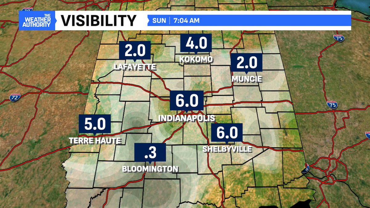
FOGGY START: Good Sunday morning! Heading out the door? If so, you'll likely encounter fog due to the rains we had last night. It's relatively thick in spots. Check out that 0.3" of visibility in Bloomington (Monroe Co). #INwx <a href="/FOX59/">FOX59 News</a>
Ethan Rosuck (@ethanrosuckwx) 's Twitter Profile Photo

RELIEF FROM HUMIDITY? Unfortunately, no BIG differences even though the drier air is just to our northwest. A cold front sags south and an upper-level wave will later spark storms near it. Storm coverage ramps up late afternoon & evening. Stay weather aware! β›ˆοΈ #INwx FOX59 News

RELIEF FROM HUMIDITY? Unfortunately, no BIG differences even though the drier air is just to our northwest. A cold front sags south and an upper-level wave will later spark storms near it. Storm coverage ramps up late afternoon &amp; evening. Stay weather aware! β›ˆοΈ #INwx <a href="/FOX59/">FOX59 News</a>
Ethan Rosuck (@ethanrosuckwx) 's Twitter Profile Photo

MOST stay dry this afternoon but storm coverage goes up heading into the evening. Severe weather is not a concern with a very isolated wind threat in south central Indiana. Big concern again will be the heavy downpours like the previous rains we've seen. #INwx FOX59 News

MOST stay dry this afternoon but storm coverage goes up heading into the evening. Severe weather is not a concern with a very isolated wind threat in south central Indiana. Big concern again will be the heavy downpours like the previous rains we've seen. #INwx <a href="/FOX59/">FOX59 News</a>
Ethan Rosuck (@ethanrosuckwx) 's Twitter Profile Photo

More of the same this week! A very mid-July pattern across central Indiana with slightly warmer temps, humidity sticking around with daily rain chances. No 100Β°+ heat indices are in the forecast but the air will be sticky all week long. #INwx FOX59 News
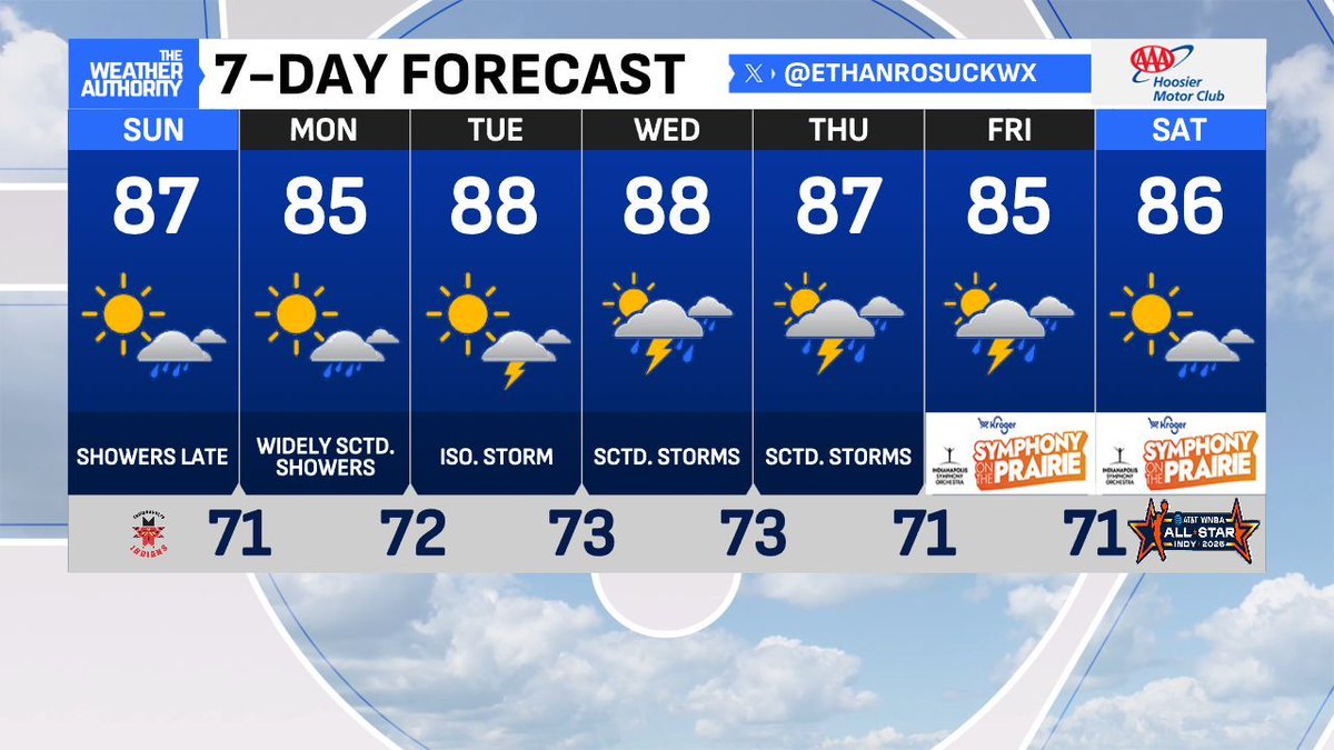
More of the same this week! A very mid-July pattern across central Indiana with slightly warmer temps, humidity sticking around with daily rain chances. No 100Β°+ heat indices are in the forecast but the air will be sticky all week long. #INwx <a href="/FOX59/">FOX59 News</a>
Ethan Rosuck (@ethanrosuckwx) 's Twitter Profile Photo

Outflow boundary spawning more summer storms in central Indiana. Right on schedule. These are moving east with #Indianapolis next for the rain! Thunder, lightning, downpours and some higher wind gusts likely. #INwx β›ˆοΈβ›ˆοΈ