Gisat (@gisat_cz) 's Twitter Profile
Gisat

@gisat_cz

ID: 1191357942370578443

calendar_today04-11-2019 14:14:46

16 Tweet

51 Followers

22 Following

EU Grassland Watch (@eu_grasslands) 's Twitter Profile Photo

We'd like to thank Pavel Milenov & EU_ScienceHub for hosting a successfully progress meeting of our project to monitor #Natura2000 sites dominated by grasslands. It was good to describe the key components of the service to #JRC, EU Agriculture🌱, EU Environment & EU EnvironmentAgency colleagues. 🙏

We'd like to thank Pavel Milenov  &amp; <a href="/EU_ScienceHub/">EU_ScienceHub</a> for hosting a successfully progress meeting of our project to monitor #Natura2000 sites dominated by grasslands. It was good to describe the key components of the service to #JRC, <a href="/EUAgri/">EU Agriculture🌱</a>, <a href="/EU_ENV/">EU Environment</a> &amp; <a href="/EUEnvironment/">EU EnvironmentAgency</a> colleagues. 🙏
World Bank Cities (@wbg_cities) 's Twitter Profile Photo

Tomas Soukup Gisat: Space tech that has huge potential to help collect geospatial data, create #BetterPublicSpaces, and build livable cities for all. worldbank.org/hiddenwealthof… #WUF10

Tomas Soukup <a href="/Gisat_cz/">Gisat</a>: Space tech that has huge potential to help collect geospatial data, create #BetterPublicSpaces, and build livable cities for all. worldbank.org/hiddenwealthof… #WUF10
EOX (@eox_a) 's Twitter Profile Photo

Call for action from the Euro Data Cube to get all the #EO ideas on how to help to tackle the #COVID19 crisis. Take the initiative at: eox.at/2020/04/covid-… find the "Signup here!" at the bottom and get started for free. Sentinel Hub @planetlabs Brockmann Consult Gisat ESA Earth Observation


Gisat (@gisat_cz) 's Twitter Profile Photo

Gisat has launched the #FUORE tool. This user-friendly web application allows to interactively explore and analyse geo-based/related statistical data. It serves as a support for regional planning and policy-making. ▶️fuore.eu ESPON

<a href="/Gisat_cz/">Gisat</a> has launched the #FUORE tool. This user-friendly web application allows to interactively explore and analyse geo-based/related statistical data. It serves as a support for regional planning and policy-making.
▶️fuore.eu
<a href="/ESPON_Programme/">ESPON</a>
Copernicus EU (@copernicuseu) 's Twitter Profile Photo

🔴 At 17:08 UTC yesterday, #Copernicus #Sentinel1 🇪🇺🛰️captured the 1⃣st image of #HungaTonga 🌋after the destructive eruption The volcanic island is almost completely wiped out ⬇️ Comparison before (3 Jan.) / after (image of 15 Jan., ~12 hours after the eruption) #Tonga

ESA WorldCereal (@esa_worldcereal) 's Twitter Profile Photo

A story on the Russian invasion of #Ukraine & impact on the global #food supply & prices 👇 Discover how NASA Harvest & partners track the impact on the global #food system with support from #WorldCereal to analyze #crop planting, harvest & yields 🌾🌏🙏 earthobservatory.nasa.gov/images/150025/…

A story on the Russian invasion of #Ukraine &amp; impact on the global #food supply &amp; prices 👇

Discover how <a href="/NASAHarvest/">NASA Harvest</a> &amp; partners track the impact on the global #food system with support from #WorldCereal to analyze #crop planting, harvest &amp; yields 🌾🌏🙏

earthobservatory.nasa.gov/images/150025/…
VITO Remote Sensing (@vito_rs_) 's Twitter Profile Photo

Today at the #AARSE2022 conference in Rwanda! 👇 Dr Zoltan Szantoi European Space Agency talked about the importance of #EOdata to support #agriculture in his presentation on #EOAfrica, including the upcoming #WorldCereal map for dynamic global #crop mapping! 🌾🌍👨‍💻 ➡️ esa-worldcereal.org/en

Today at the #AARSE2022 conference in Rwanda! 👇

Dr Zoltan Szantoi <a href="/esa/">European Space Agency</a> talked about the importance of #EOdata to support #agriculture in his presentation on #EOAfrica, including the upcoming #WorldCereal map for dynamic global #crop mapping! 🌾🌍👨‍💻

➡️ esa-worldcereal.org/en
ESA WorldCereal (@esa_worldcereal) 's Twitter Profile Photo

Day 2⃣ of the #WorldCereal Workshop! 🤩🇨🇭 Yesterday the team focused on presenting the results of the project. Today we have training sessions on the specific modules of the #WorldCereal system. 🌾🌍👨‍💻 Stay tuned for the public release coming soon! ➡️ esa-worldcereal.org/en

Day 2⃣ of the #WorldCereal Workshop! 🤩🇨🇭

Yesterday the team focused on presenting the results of the project. Today we have training sessions on the specific modules of the #WorldCereal system. 🌾🌍👨‍💻

Stay tuned for the public release coming soon!
➡️ esa-worldcereal.org/en
ESA Earth Observation (@esa_eo) 's Twitter Profile Photo

Between 2017 and 2021, 5.2 million hectares of forest (roughly the size of Costa Rica) has been lost in the Amazon basin. This is what an European Space Agency-led project discovered processing billions of Copernicus EU #Sentinel1 images with a space-time data cube design: esa.int/Applications/O…

Between 2017 and 2021, 5.2 million hectares of forest (roughly the size of Costa Rica) has been lost in the Amazon basin. This is what an <a href="/esa/">European Space Agency</a>-led project discovered processing billions of <a href="/CopernicusEU/">Copernicus EU</a> #Sentinel1 images with a space-time data cube design: esa.int/Applications/O…
ESA WorldCereal (@esa_worldcereal) 's Twitter Profile Photo

Only 3⃣ more days till the #WorldCereal release webinar! Join us to discover the world’s first🥇dynamic system for seasonally-updated 10 m #cropland maps 🌾 at global scale 🌍 🗓️ 20 April ⏰ 13:30 ✍️bit.ly/WorldCereal_Ne… ESA Earth Observation IIASA Geo-Wiki Gisat VITO Remote Sensing Wageningen U&R eLEAF
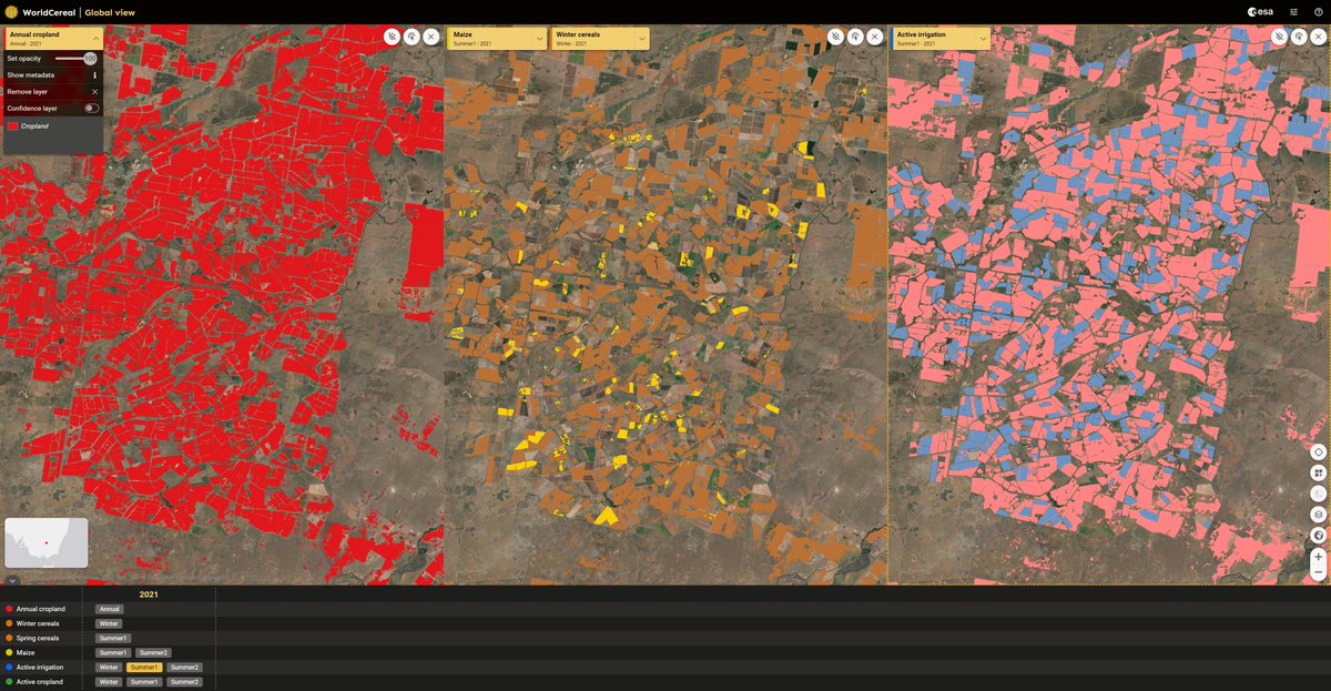
Only 3⃣ more days till the #WorldCereal release webinar! 

Join us to discover the world’s first🥇dynamic system for seasonally-updated 10 m #cropland maps 🌾 at global scale 🌍

🗓️ 20 April
⏰ 13:30
✍️bit.ly/WorldCereal_Ne…

<a href="/ESA_EO/">ESA Earth Observation</a> <a href="/Geo_Wiki/">IIASA Geo-Wiki</a> <a href="/Gisat_cz/">Gisat</a> <a href="/VITO_RS_/">VITO Remote Sensing</a> <a href="/WUR/">Wageningen U&R</a> <a href="/eleaf/">eLEAF</a>
ESA WorldCereal (@esa_worldcereal) 's Twitter Profile Photo

📢 #webinar recording of the #WorldCereal release is now available online! 🌾🌍👨‍💻 Check it out to discover more about the world’s first seasonally-updated 10m cropland & #crop-type maps! ✅ In situ data ✅ Methodology ✅ Validation ✅ online viewer 👇 bit.ly/WorldCereal_Ne…

📢 #webinar recording of the #WorldCereal release is now available online! 🌾🌍👨‍💻

Check it out to discover more about the world’s first seasonally-updated 10m cropland &amp; #crop-type maps!

✅ In situ data 
✅ Methodology
✅ Validation
✅ online viewer 👇

bit.ly/WorldCereal_Ne…
GAF AG (@gaf_munich) 's Twitter Profile Photo

Successfully combating #ClimateChange and #urban heat in Sargodha, Pakistan with #satellite #EOdata 🛰➡️ by European Space Agency GDA AID Urban Sustainability for Asian Development Bank. #CitiesWithNature With 👉 GAF AG DLR_de AIT Gisat @caribouspace full story: gda.esa.int/story/changing…

Successfully combating #ClimateChange and #urban heat in Sargodha, Pakistan with #satellite #EOdata 🛰➡️ by <a href="/esa/">European Space Agency</a> GDA AID Urban Sustainability for <a href="/ADB_HQ/">Asian Development Bank</a>. #CitiesWithNature With 👉 <a href="/GAF_Munich/">GAF AG</a> <a href="/DLR_de/">DLR_de</a> <a href="/AITtomorrow2day/">AIT</a> <a href="/Gisat_cz/">Gisat</a> @caribouspace full story:
 gda.esa.int/story/changing…