Illinois State Climatologist (@ilclimatologist) 's Twitter Profile
Illinois State Climatologist

@ilclimatologist

Official account for the Illinois State Climatologist Office. Located at the Illinois State Water Survey and Prairie Research Institute

ID: 1050411790323109890

linkhttp://go.illinois.edu/climatologist calendar_today11-10-2018 15:44:21

1,1K Tweet

1,1K Followers

1,1K Following

NWS Chicago (@nwschicago) 's Twitter Profile Photo

Good afternoon! We continue to work through hundreds of damage points from last week's severe weather. This thread will cover the latest information specific to the 7/15 (Monday) derecho. A summary map of all confirmed tornadoes from 7/15 is below. (1/10)

Good afternoon! We continue to work through hundreds of damage points from last week's severe weather. This thread will cover the latest information specific to the 7/15 (Monday) derecho. A summary map of all confirmed tornadoes from 7/15 is below. (1/10)
Illinois State Climatologist (@ilclimatologist) 's Twitter Profile Photo

We've had a nice reprieve from the summer heat, but not for much longer. NWS Climate Prediction Center outlooks are showing higher chances of excessive heat in the first week of August for the entire state. Never too many reminders of the importance of heat safety: redcross.org/content/dam/re….
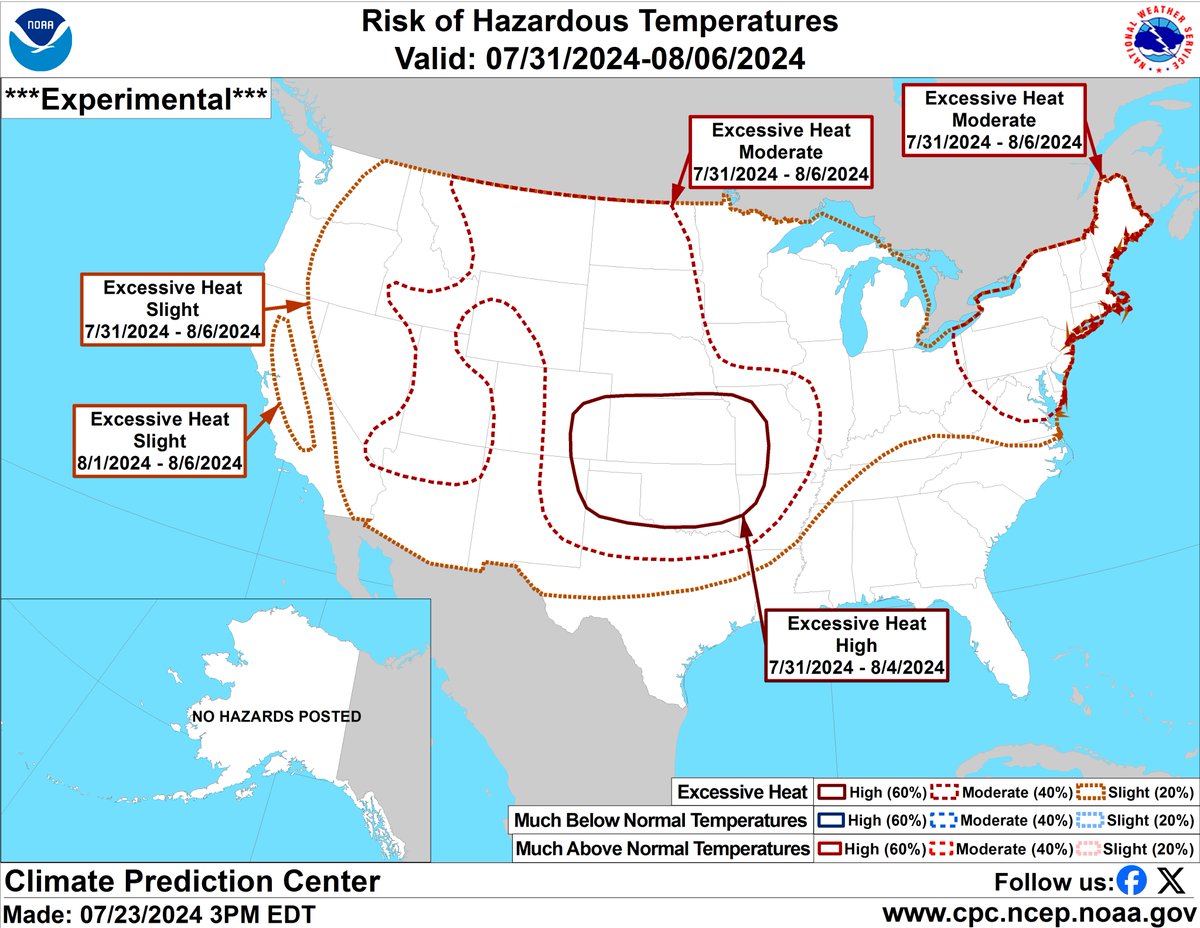
We've had a nice reprieve from the summer heat, but not for much longer. <a href="/NWSCPC/">NWS Climate Prediction Center</a> outlooks are showing higher chances of excessive heat in the first week of August for the entire state. 

Never too many reminders of the importance of heat safety: redcross.org/content/dam/re….
NWS Paducah, KY (@nwspaducah) 's Twitter Profile Photo

Afternoon heat index readings Tuesday through Thursday will reach 105 to 110 degrees, with some areas possibly even reaching near 115 degrees. Thunderstorms may provide some relief, but there is considerable uncertainty on timing and location.

Afternoon heat index readings Tuesday through Thursday will reach 105 to 110 degrees, with some areas possibly even reaching near 115 degrees. Thunderstorms may provide some relief, but there is considerable uncertainty on timing and location.
NWS Lincoln IL (@nwslincolnil) 's Twitter Profile Photo

830 update: portions of west central IL upgraded to enhanced risk. There is considerable uncertainty with how strong to severe storms will evolve over the region today, but if they do occur, there is potential for wind gusts to exceed 70-75 mph as far east as about I-57. #ILwx

830 update: portions of west central IL upgraded to enhanced risk. There is considerable uncertainty with how strong to severe storms will evolve over the region today, but if they do occur, there is potential for wind gusts to exceed 70-75 mph as far east as about I-57. #ILwx
NWS Lincoln IL (@nwslincolnil) 's Twitter Profile Photo

Prepare for another round of heat this afternoon, most notably south of I-72 ahead of an advancing cold front. The combination of heat and humidity will result in heat indices in the 100-105 F range. Take precautions if you need to be outside. #ILwx

Prepare for another round of heat this afternoon, most notably south of I-72 ahead of an advancing cold front. The combination of heat and humidity will result in heat indices in the 100-105 F range. Take precautions if you need to be outside. #ILwx
Anna Wolverton (@annaewolverton) 's Twitter Profile Photo

Drought is gradually spreading in the Mississippi Valley, particularly the Ohio and Lower Miss sub-basins. Not great news since the Ohio basin is the main contributor to the mainstem Miss River. The big river is generally falling currently.

Drought is gradually spreading in the Mississippi Valley, particularly the Ohio and Lower Miss sub-basins. Not great news since the Ohio basin is the main contributor to the mainstem Miss River. The big river is generally falling currently.
NWS Lincoln IL (@nwslincolnil) 's Twitter Profile Photo

Dangerous heat and humidity slowly expand west-east across central and southeast Illinois today into tomorrow. Heat indices are forecast to peak for much of the area tomorrow, with values of 105 to 115 common during the afternoon. #ILwx

Dangerous heat and humidity slowly expand west-east across central and southeast Illinois today into tomorrow. Heat indices are forecast to peak for much of the area tomorrow, with values of 105 to 115 common during the afternoon. #ILwx
NWS Chicago (@nwschicago) 's Twitter Profile Photo

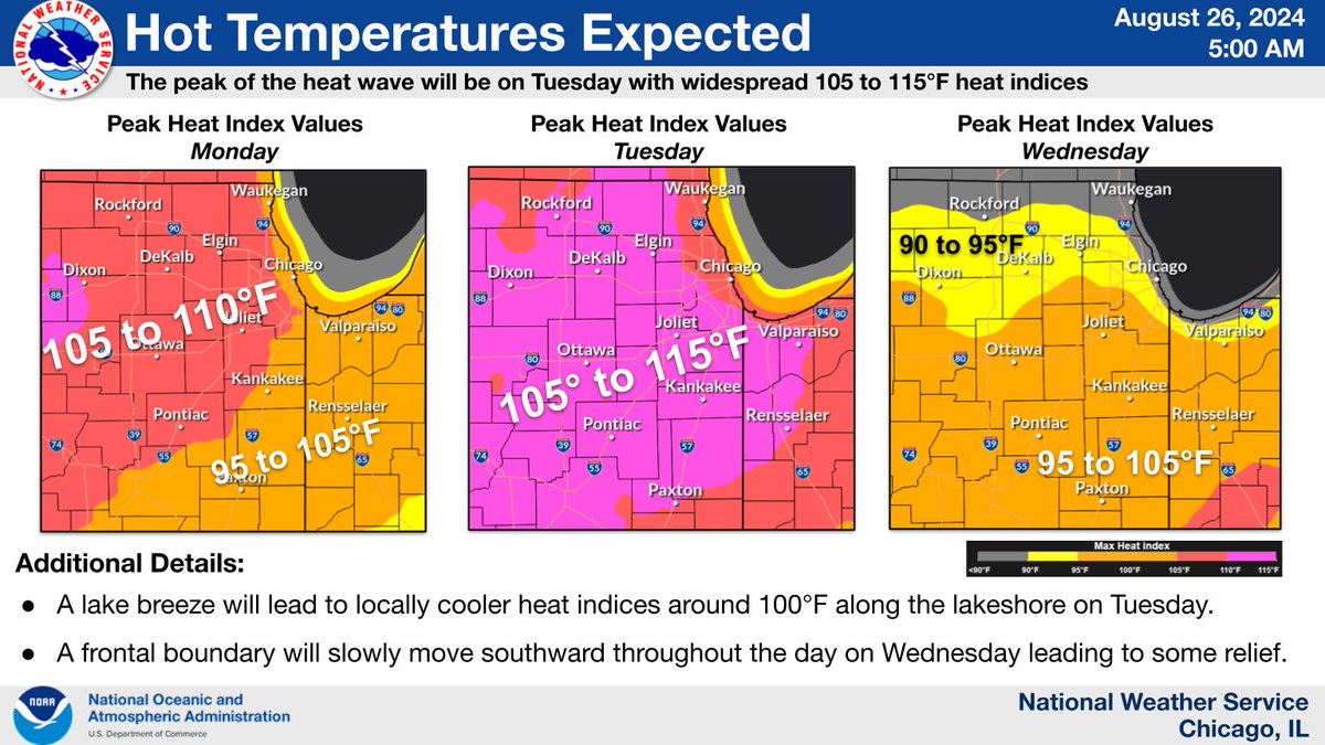
A heat wave continues to build today and peak on Tuesday with gradual easing on Wednesday. Consider altering your outdoor plans including school sports practices. This is the hottest air that we’ve experienced so far this summer. #ILwx #INwx

A heat wave continues to build today and peak on Tuesday with gradual easing on Wednesday. Consider altering your outdoor plans including school sports practices. This is the hottest air that we’ve experienced so far this summer. #ILwx #INwx
NWS Chicago (@nwschicago) 's Twitter Profile Photo

Assuming the temperature doesn't get any lower before 1 AM tonight (midnight CST), and it isn't expected to, this morning's 79°F low temperature in #Chicago will break the record warm low for Aug 26th. The previous record was 77°F set back in 1973. #ilwx

MortonArboretum (@mortonarboretum) 's Twitter Profile Photo

As temperatures soar into the 90s, trees and garden plants need extra care. Make sure they have enough water and check the soil moisture regularly to keep them thriving. The Arboretum's Plant Clinic has tips about how to water trees and shrubs and keep plants healthy amid the

As temperatures soar into the 90s, trees and garden plants need extra care. Make sure they have enough water and check the soil moisture regularly to keep them thriving. The Arboretum's Plant Clinic has tips about how to water trees and shrubs and keep plants healthy amid the
NWS Chicago (@nwschicago) 's Twitter Profile Photo

The hottest day of the heat wave is expected today with heat indices climbing to 105 to 110 degrees. An Excessive Heat Warning is in effect for all of northern IL, while a heat advisory is in effect for for much of northwestern Indiana. #ILwx #INwx

The hottest day of the heat wave is expected today with heat indices climbing to 105 to 110 degrees. An Excessive Heat Warning is in effect for all of northern IL, while a heat advisory is in effect for for much of northwestern Indiana. #ILwx #INwx
Illinois State Climatologist (@ilclimatologist) 's Twitter Profile Photo

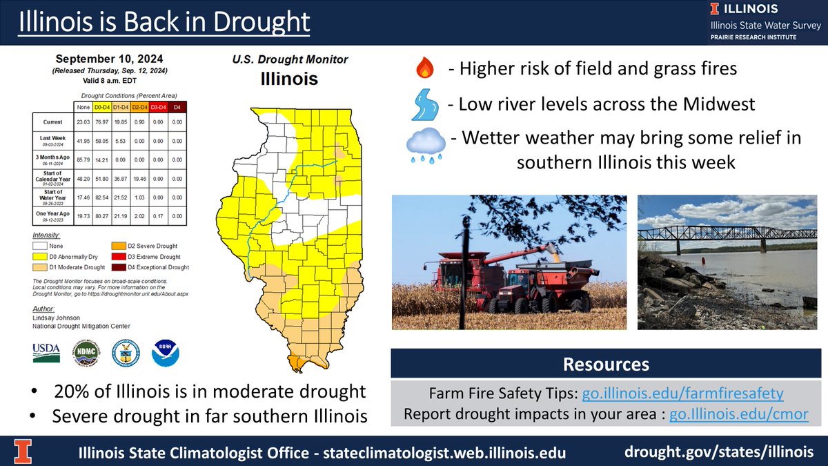
Unfortunately, we're back to talking #Drought in Illinois. Concerns include field and grass fire risk, low levels on major rivers, and damage to pasture and late-planted crops. #francine may provide some relief to southern Illinois this week. #ilwx go.illinois.edu/IllinoisDrought

Unfortunately, we're back to talking #Drought in Illinois. Concerns include field and grass fire risk, low levels on major rivers, and damage to pasture and late-planted crops. 
#francine may provide some relief to southern Illinois this week. #ilwx
go.illinois.edu/IllinoisDrought
Bill Snyder (@billyweather) 's Twitter Profile Photo

HISTORIC LATE SEASON WARMTH: Today marked the 11th consecutive day with 80°+ temperatures, the longest string of 80s this late in the season on record since observations began in 1871! Old record: 10 days in 1952! #ilwx #inwx ☀️😎🔥

HISTORIC LATE SEASON WARMTH: Today marked the 11th consecutive day with 80°+ temperatures, the longest string of 80s this late in the season on record since observations began in 1871! Old record: 10 days in 1952! #ilwx #inwx ☀️😎🔥
Illinois State Climatologist (@ilclimatologist) 's Twitter Profile Photo

Our first fall freeze here in central Illinois is right on "schedule" based on the latest climate normals. Sub-freezing temps this morning were 1-2 weeks ahead of normal in places like Cahokia Heights and Carbondale. stateclimatologist.web.illinois.edu/data/frost-dat… #ilwx

Our first fall freeze here in central Illinois is right on "schedule" based on the latest climate normals. Sub-freezing temps this morning were 1-2 weeks ahead of normal in places like Cahokia Heights and Carbondale.
stateclimatologist.web.illinois.edu/data/frost-dat… #ilwx
NWS Lincoln IL (@nwslincolnil) 's Twitter Profile Photo

HEADS UP! There is a fire noted near Ogden, IL showing up on satellite late this afternoon. If you are driving in that area, including on I-74, be alert that there may be smoke around! #ILwx

HEADS UP! There is a fire noted near Ogden, IL showing up on satellite late this afternoon. If you are driving in that area, including on I-74, be alert that there may be smoke around! #ILwx