Instant Weather Ontario ⛈️ (@iweatheron) 's Twitter Profile
Instant Weather Ontario ⛈️

@iweatheron

Ontario's independent and community-driven weather organization. Providing context to severe weather since 2013. Download our app: InstantWeather.ca/app

ID: 1375783214

linkhttps://instantweather.ca/ontario calendar_today24-04-2013 00:24:37

42,42K Tweet

67,67K Followers

927 Following

Instant Weather Ontario ⛈️ (@iweatheron) 's Twitter Profile Photo

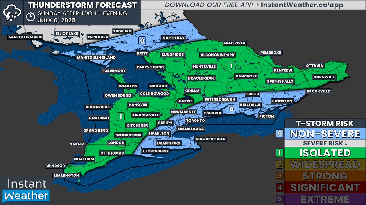
#ONStorm #ONwx ⛈️ Isolated Severe Storm Risk Today (Sunday) DATE: Sunday, July 6, 2025 Good afternoon! Apologies for the delay in getting today’s thunderstorm forecast out. We had hoped to post it last night alongside a detailed forecast article, but the evening model data

#ONStorm #ONwx ⛈️ Isolated Severe Storm Risk Today (Sunday)

DATE: Sunday, July 6, 2025

Good afternoon! Apologies for the delay in getting today’s thunderstorm forecast out. We had hoped to post it last night alongside a detailed forecast article, but the evening model data
Instant Weather Ontario ⛈️ (@iweatheron) 's Twitter Profile Photo

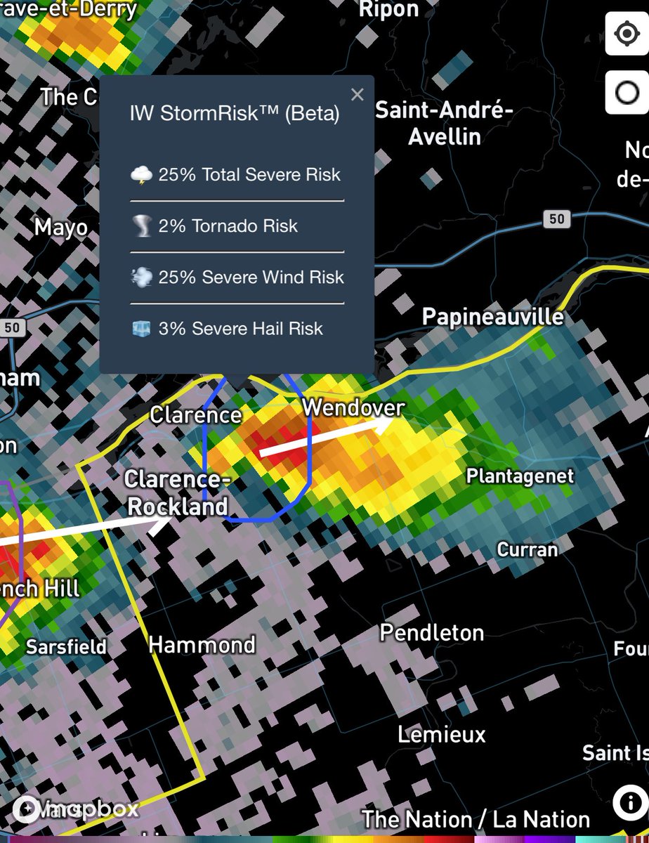
#ONStorm #ONwx Keeping an eye on this severe warned cell just east of Clarence-Rockland tracking into Wendover. Looking quite strong and could be producing severe wind gusts with a 25% risk according to IW StormRisk. What are you experiencing? - Brennen 2:18 PM - Sunday, July

#ONStorm #ONwx Keeping an eye on this severe warned cell just east of Clarence-Rockland tracking into Wendover.

Looking quite strong and could be producing severe wind gusts with a 25% risk according to IW StormRisk.

What are you experiencing?

- Brennen

2:18 PM - Sunday, July
Instant Weather Ontario ⛈️ (@iweatheron) 's Twitter Profile Photo

#onstorm 3:27p SPECIAL WEATHER STATEMENT ENDED by Environment Canada Algonquin Burk's Falls - Bayfield Inlet instantweather.ca/2025/07/06/odm…

Instant Weather Ontario ⛈️ (@iweatheron) 's Twitter Profile Photo

#onstorm 3:43p RAINFALL WARNING ISSUED by Environment Canada Greater Sudbury And Vicinity Espanola - Killarney North Bay - West Nipissing instantweather.ca/2025/07/06/wY9…

Instant Weather Ontario ⛈️ (@iweatheron) 's Twitter Profile Photo

#onstorm 3:56p SPECIAL WEATHER STATEMENT ENDED by Environment Canada Greater Sudbury And Vicinity Espanola - Killarney North Bay - West Nipissing instantweather.ca/2025/07/06/Bma…

Instant Weather Ontario ⛈️ (@iweatheron) 's Twitter Profile Photo

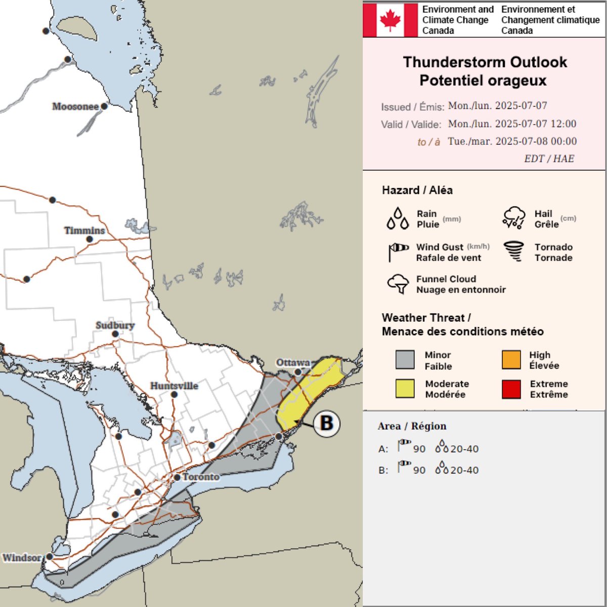
#onstorm Environment Canada is forecasting the risk for severe thunderstorms today (Mon, July 7, 2025) with 90km/h wind gusts & 20-40mm of rain in the yellow “B” zone. This could include #Cornwall & parts of eastern Ontario. The “A” zone in the legend is referring to areas west

#onstorm Environment Canada is forecasting the risk for severe thunderstorms today (Mon, July 7, 2025) with 90km/h wind gusts & 20-40mm of rain in the yellow “B” zone. This could include  #Cornwall & parts of eastern Ontario. The “A” zone in the legend is referring to areas west
Instant Weather Ontario ⛈️ (@iweatheron) 's Twitter Profile Photo

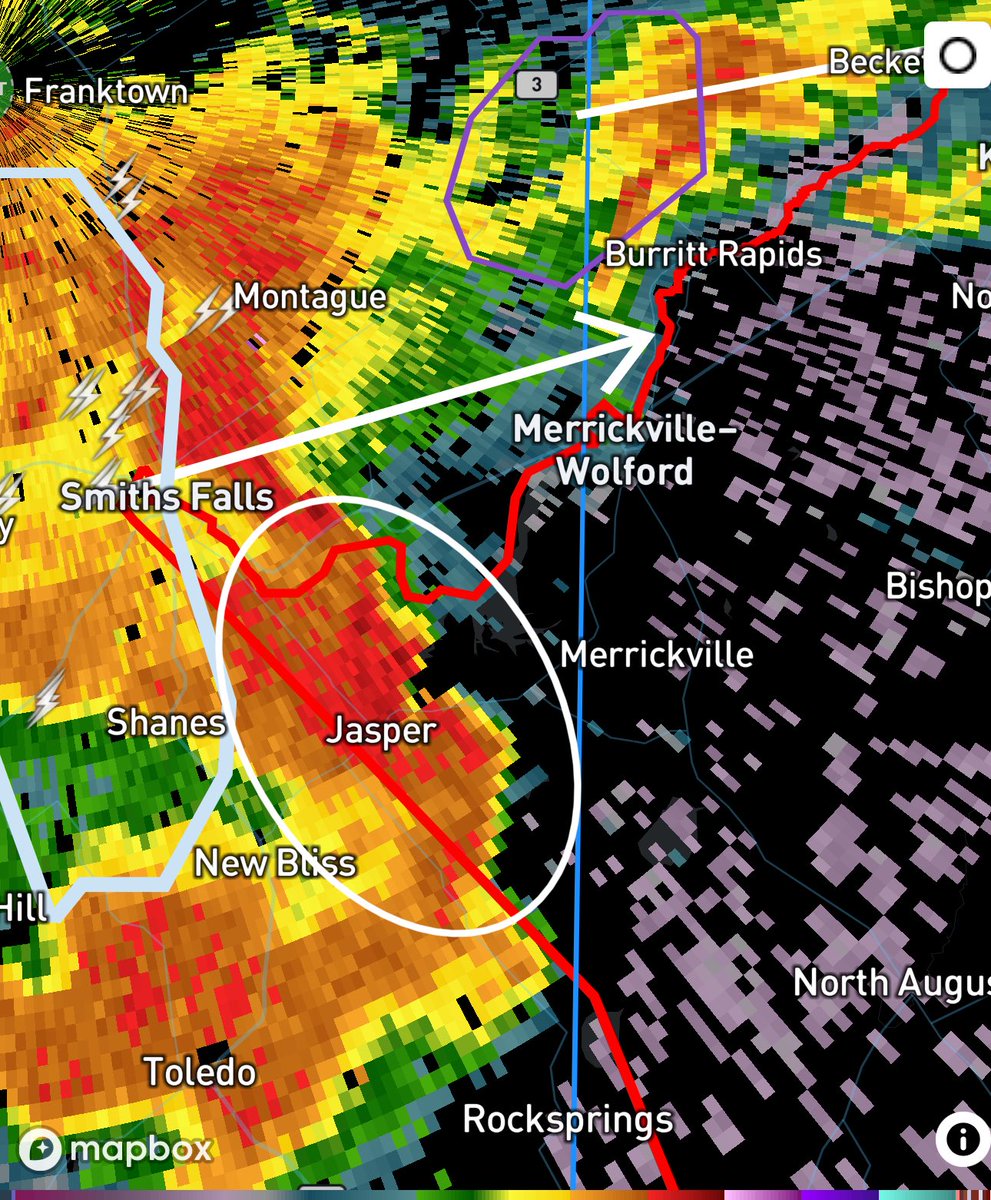
#ONStorm #ONwx 🌪️ TORNADO WARNING ISSUED If you are in the Merrickville and Smiths Falls area, you need to be seeking shelter NOW! A tornado is possibly being produced by this storm moving through the area. - Brennen 3:24 PM - Monday, July 7, 2025

#ONStorm #ONwx 🌪️ TORNADO WARNING ISSUED

If you are in the Merrickville and Smiths Falls area, you need to be seeking shelter NOW!

A tornado is possibly being produced by this storm moving through the area.

- Brennen

3:24 PM - Monday, July 7, 2025
Instant Weather Ontario ⛈️ (@iweatheron) 's Twitter Profile Photo

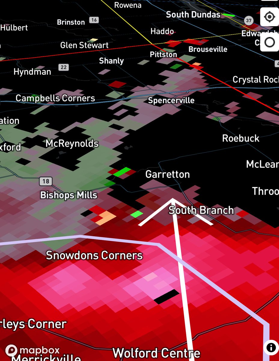
#ONStorm #ONwx Here’s a look at the projected path of the tornado warned storm southeast of Smiths Falls. Strongest area is currently located near Snowdons Corners tracking towards Garretton, McReynolds, Roebuck, Spencerville and Campbells Corners. If you are in any of these

#ONStorm #ONwx Here’s a look at the projected path of the tornado warned storm southeast of Smiths Falls.

Strongest area is currently located near Snowdons Corners tracking towards Garretton, McReynolds, Roebuck, Spencerville and Campbells Corners.

If you are in any of these
Instant Weather Ontario ⛈️ (@iweatheron) 's Twitter Profile Photo

#onstorm 3:44p SEVERE THUNDERSTORM WARNING ENDED by Environment Canada Westport - Charleston Lake Smiths Falls - Perth - Eastern Lanark County instantweather.ca/2025/07/07/OBR…

Instant Weather Ontario ⛈️ (@iweatheron) 's Twitter Profile Photo

#onstorm 3:48p TORNADO WARNING ISSUED by Environment Canada Morrisburg - Long Sault Winchester - Newington instantweather.ca/2025/07/07/BbL…

Instant Weather Ontario ⛈️ (@iweatheron) 's Twitter Profile Photo

#onstorm 4:01p SEVERE THUNDERSTORM WARNING ISSUED by Environment Canada Merrickville-Wolford - Kemptville Morrisburg - Long Sault Winchester - Newington instantweather.ca/2025/07/07/pxJ…

Instant Weather Ontario ⛈️ (@iweatheron) 's Twitter Profile Photo

#onstorm 4:01p SEVERE THUNDERSTORM WARNING ENDED by Environment Canada Ottawa South - Richmond - Metcalfe instantweather.ca/2025/07/07/NN9…

Instant Weather Ontario ⛈️ (@iweatheron) 's Twitter Profile Photo

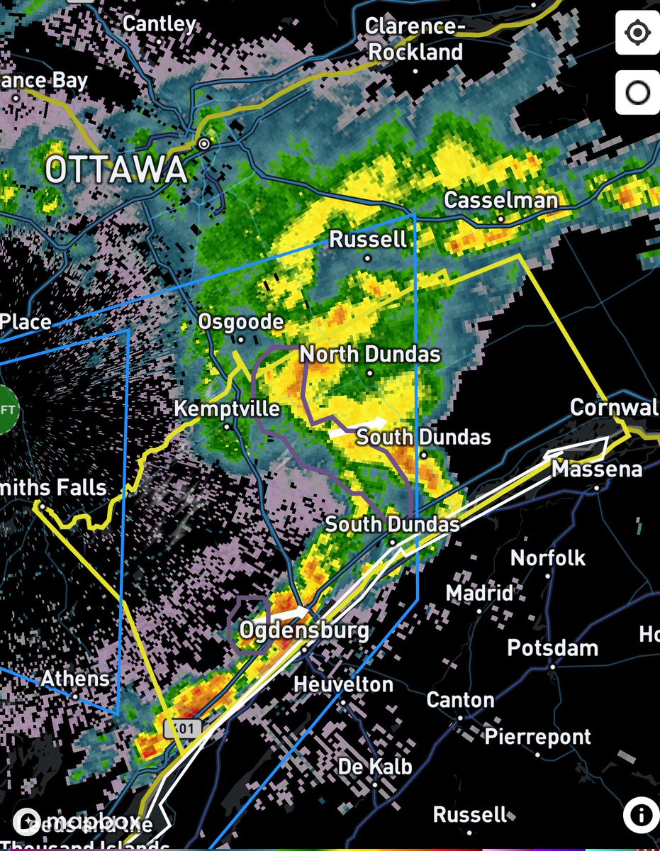
#ONStorm #ONwx TORNADO WARNING ENDED The storm that prompted the earlier tornado warning from Environment Canada has weakened substantially in the last 10-15 minutes. And as a result, the tornado warning has been downgraded to a severe thunderstorm warning. The main risk at

#ONStorm #ONwx TORNADO WARNING ENDED

The storm that prompted the earlier tornado warning from Environment Canada has weakened substantially in the last 10-15 minutes.

And as a result, the tornado warning has been downgraded to a severe thunderstorm warning. The main risk at
Instant Weather Ontario ⛈️ (@iweatheron) 's Twitter Profile Photo

#onstorm 4:14p SEVERE THUNDERSTORM WARNING ENDED by Environment Canada Brockville - Prescott Merrickville-Wolford - Kemptville Morrisburg - Long Sault Winchester - Newington instantweather.ca/2025/07/07/nu4…

Instant Weather Ontario ⛈️ (@iweatheron) 's Twitter Profile Photo

#onstorm 4:19p SEVERE THUNDERSTORM WATCH ENDED by Environment Canada Kaladar - Bannockburn - Bon Echo Park City Of Ottawa Smiths Falls - Lanark - Sharbot Lake instantweather.ca/2025/07/07/CHA…

Instant Weather Ontario ⛈️ (@iweatheron) 's Twitter Profile Photo

#onstorm 6:41p SEVERE THUNDERSTORM WATCH ENDED by Environment Canada Napanee - Consecon Kingston - Odessa - Frontenac Islands Stirling - Tweed - South Frontenac Brockville - Leeds And Grenville Prescott And Russell Cornwall - Morrisburg instantweather.ca/2025/07/07/lx5…