Joey Crist (@joeycrist_wx) 's Twitter Profile
Joey Crist

@joeycrist_wx

@msstate Broadcast & Operational Meteorology | 19 | @VortixWX @TeamBoltWX @AppyWxCrew

ID: 1500626836342063106

linkhttps://www.youtube.com/channel/UCe5gMUwlT3e37Lb2DpfSxNQ calendar_today07-03-2022 00:18:27

14,14K Tweet

1,1K Followers

3,3K Following

Vast (@vastgg) 's Twitter Profile Photo

$3,000 Gaming PC or $3,000 Cash Giveaway! #ad ☑️ RTX 5070 Ti ☑️ Intel Core Ultra 9 To enter, perform these tasks via the link below: 🔁 Repost + Like ✅Follow First Break Labs + Underwater Fire Games Enter Here: vast.link/PH

$3,000 Gaming PC or $3,000 Cash Giveaway! #ad

☑️ RTX 5070 Ti
☑️ Intel Core Ultra 9

To enter, perform these tasks via the link below:
🔁 Repost + Like 
✅Follow <a href="/FirstBreakLabs/">First Break Labs</a> + <a href="/UFireGames/">Underwater Fire Games</a>

Enter Here: vast.link/PH
Hunte☈ Fowkes (@strmchsrhunterf) 's Twitter Profile Photo

There are so many physical properties that go into why the dominator got pivoted into a 90⁰ left turn by a sub vortex. In short form, the dominator was impacted by a fast moving strong sub vortex on the passenger side front. Due to intense pressure falls in the tornado, and

There are so many physical properties that go into why the dominator got pivoted into a 90⁰ left turn by a sub vortex. 

In short form, the dominator was impacted by a fast moving strong sub vortex on the passenger side front. Due to intense pressure falls in the tornado, and
Chase Wilson (@dualdoppler) 's Twitter Profile Photo

Aerial views today from Tanner, AL and Killingsworth Cove Rd. Alabama, where several intense tornadoes touched down yesterday evening. Several areas of mass treefall and cycloidal markings are present amongst the damaged areas

Aerial views today from Tanner, AL and Killingsworth Cove Rd. Alabama, where several intense tornadoes touched down yesterday evening. Several areas of mass treefall and cycloidal markings are present amongst the damaged areas
Billy Bowling  𝕏 (@babowling12) 's Twitter Profile Photo

Some scenes from Tuesdays chase in Alabama. HP mess made spotting the 3 tornadoes of the day hard to spot for me, but JFC at the colors. 2 days later and my ears are still ringing from no less than 30 CGs within 10 yards of me that afternoon. 📍 Huntsville, AL

Some scenes from Tuesdays chase in Alabama. HP mess made spotting the 3 tornadoes of the day hard to spot for me, but JFC at the colors. 2 days later and my ears are still ringing from no less than 30 CGs within 10 yards of me that afternoon. 

📍 Huntsville, AL
Joey Crist (@joeycrist_wx) 's Twitter Profile Photo

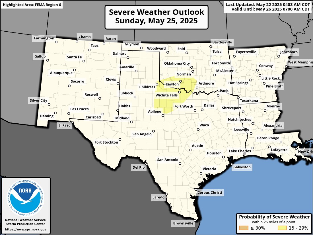
Severe storms are possible Sunday across northwest Texas and southwest Oklahoma, where strong instability and an uncapped environment could support scattered to widespread storms. A 15% risk is in place. Isolated severe storms may continue along a stalled front next week.

Severe storms are possible Sunday across northwest Texas and southwest Oklahoma, where strong instability and an uncapped environment could support scattered to widespread storms. A 15% risk is in place. Isolated severe storms may continue along a stalled front next week.
Joey Crist (@joeycrist_wx) 's Twitter Profile Photo

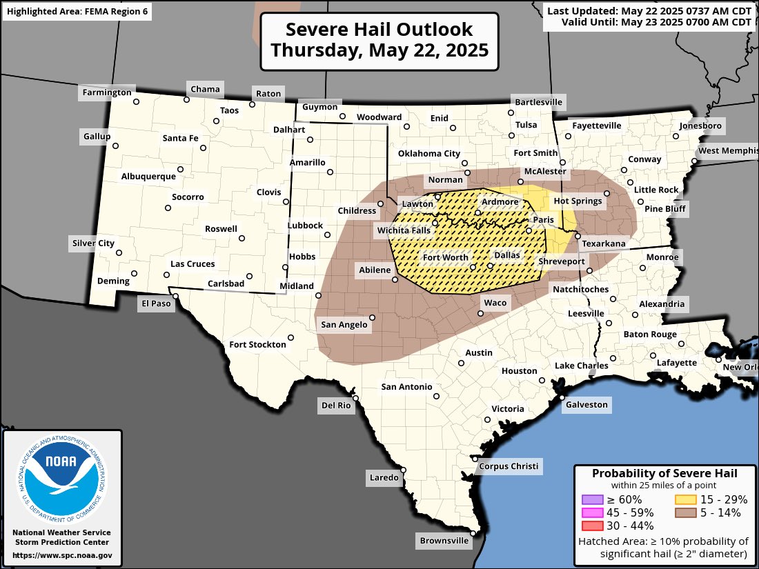
A Slight Risk is in place today for parts of northern Texas & southern Oklahoma. Scattered thunderstorms are expected this afternoon & evening, with the potential for large hail over 2 inches in diameter & damaging winds.

A Slight Risk is in place today for parts of northern Texas &amp; southern Oklahoma. Scattered thunderstorms are expected this afternoon &amp; evening, with the potential for large hail over 2 inches in diameter &amp; damaging winds.
Joey Crist (@joeycrist_wx) 's Twitter Profile Photo

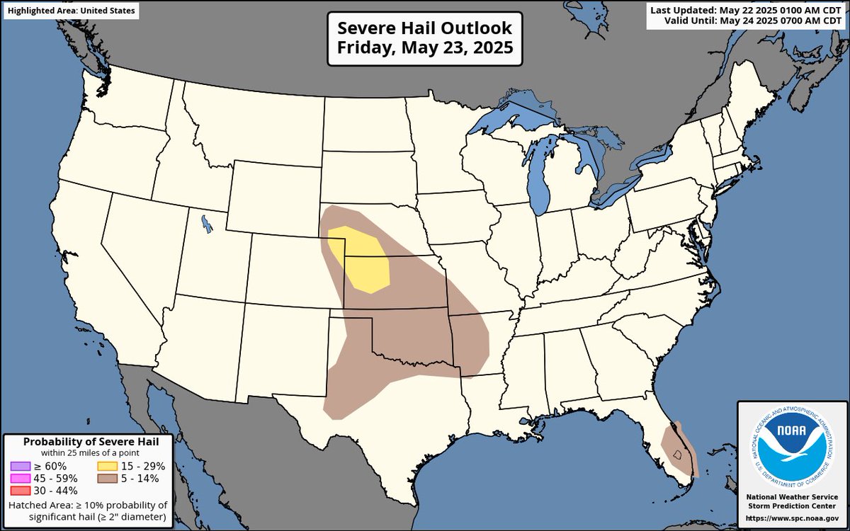
Severe storms are expected Friday across parts of the central Plains, especially NE CO, SW NE, and NW KS. Large hail and damaging winds are the main threats. Isolated severe storms are also possible in West TX and SE FL.

Severe storms are expected Friday across parts of the central Plains, especially NE CO, SW NE, and NW KS. Large hail and damaging winds are the main threats. Isolated severe storms are also possible in West TX and SE FL.
Joey Crist (@joeycrist_wx) 's Twitter Profile Photo

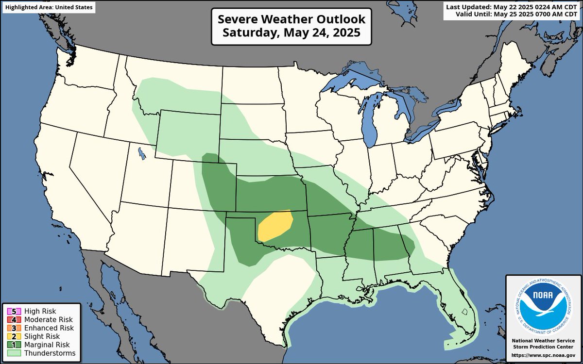
Severe storms are likely across northwest Oklahoma on Saturday, with supercells capable of very large hail, damaging winds, and perhaps a tornado or two. Additional strong storms are possible from the High Plains to the Southeast.

Severe storms are likely across northwest Oklahoma on Saturday, with supercells capable of very large hail, damaging winds, and perhaps a tornado or two. Additional strong storms are possible from the High Plains to the Southeast.
RadarOmega (@radaromega) 's Twitter Profile Photo

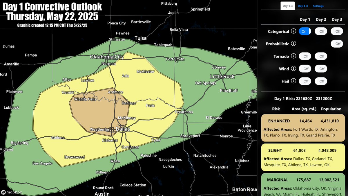
ENHANCED RISK (5/22/25): Severe storms are expected through the afternoon and evening across the southern Plains, especially across north Texas and southern Oklahoma. Large hail and damaging winds are the primary hazards, with a few instances of 2"+ hail possible. #TXwx #OKwx

ENHANCED RISK (5/22/25): Severe storms are expected through the afternoon and evening across the southern Plains, especially across north Texas and southern Oklahoma. Large hail and damaging winds are the primary hazards, with a few instances of 2"+ hail possible. #TXwx #OKwx
NWS Pittsburgh (@nwspittsburgh) 's Twitter Profile Photo

🌪️We have confirmed two EF-0 tornadoes in Butler County, PA from the evening of Wednesday 5/21/25. Both were from the same storm but discontinuous paths were observed supporting two separate tornado distinctions. The last tornado in Butler County was an EF-0 on 10/21/21... (1/2)

🌪️We have confirmed two EF-0 tornadoes in Butler County, PA from the evening of Wednesday 5/21/25. Both were from the same storm but discontinuous paths were observed supporting two separate tornado distinctions. The last tornado in Butler County was an EF-0 on 10/21/21... (1/2)
iembot_pds (@iembot_pds) 's Twitter Profile Photo

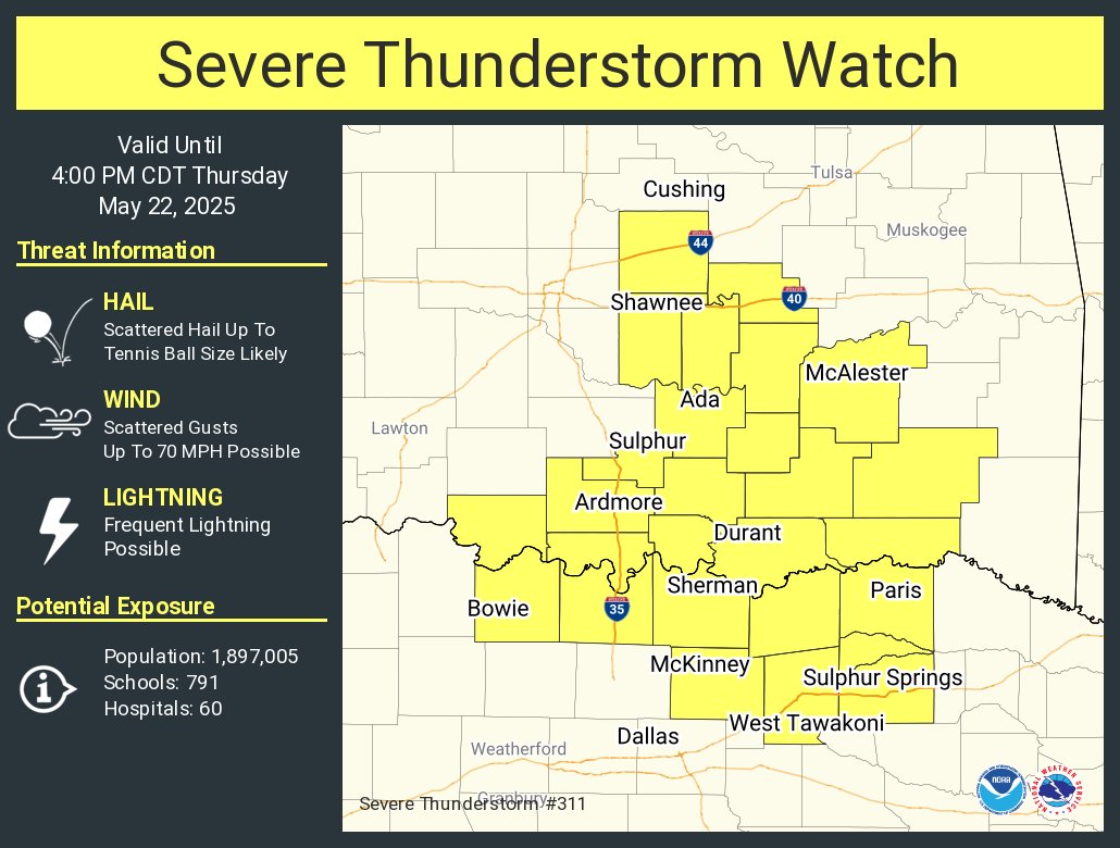
OUN continues Severe Thunderstorm Warning [damage threat: DESTRUCTIVE, wind: 60 MPH (RADAR INDICATED), hail: 2.75 IN (RADAR INDICATED)] for Stephens [OK] till 5:45 PM CDT mesonet.agron.iastate.edu/vtec/f/2025-O-…

OUN continues Severe Thunderstorm Warning [damage threat: DESTRUCTIVE, wind: 60 MPH (RADAR INDICATED), hail: 2.75 IN (RADAR INDICATED)] for Stephens [OK] till 5:45 PM CDT mesonet.agron.iastate.edu/vtec/f/2025-O-…
Joey Crist (@joeycrist_wx) 's Twitter Profile Photo

A tropical depression is likely to form by midweek a few hundred miles south of southern Mexico. Conditions appear favorable as the system tracks W to WNW at 10–15 mph.

A tropical depression is likely to form by midweek a few hundred miles south of southern Mexico. Conditions appear favorable as the system tracks W to WNW at 10–15 mph.
OTUS Project (@project_otus) 's Twitter Profile Photo

An extraordinary perspective of an anticyclonic tornado near Higgins, TX by our research drone on May 18th. Watch the full video in the link below!