Katie McGraw (@katiemcgrawx) 's Twitter Profile
Katie McGraw

@katiemcgrawx

Certified Broadcast Meteorologist by AMS (#823). Meteorologist at News 5 Cleveland. Pit stops in Louisville, Erie, Zanesville & Athens! 💚

ID: 325972506

linkhttps://www.facebook.com/KatieMcgrawx calendar_today29-06-2011 04:58:36

23,23K Tweet

5,5K Followers

788 Following

FOX Weather (@foxweather) 's Twitter Profile Photo

METEOR DAMAGE REPORTED: A home in Henry County, Georgia has reported damage from possible meteor debris after a fireball was seen shooting through the sky on Thursday afternoon. Read more: foxweather.com/earth-space/da…

METEOR DAMAGE REPORTED: A home in Henry County, Georgia has reported damage from possible meteor debris after a fireball was seen shooting through the sky on Thursday afternoon.

Read more: foxweather.com/earth-space/da…
Katie McGraw (@katiemcgrawx) 's Twitter Profile Photo

[Friday, June 27, 8:45 pm] Continuing to monitor the radar as a cold front approaches the area. The second line of storms is trying very hard to form. There is 1 strong storm near Tiffin. A few storms are still expected tonight. Listen for thunder and seek shelter if you hear it!

Katie McGraw (@katiemcgrawx) 's Twitter Profile Photo

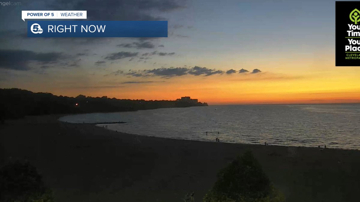
Check out the light show from Edgewater Beach as a storm moves NE over the lake, just north of Lorain. This is the same storm that first developed near Tiffin, the rest of NEO is looking dry!

Katie McGraw (@katiemcgrawx) 's Twitter Profile Photo

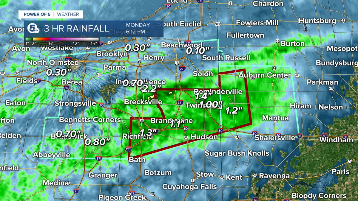
A FLASH FLOOD WARNING has been issued for portions of Summit, Geauga and Portage County until 9:15 pm on June 30th ater 1-2 inches of rain have fallen. Most of that in just the last hour. Use extreme caution on the roads over the next few hours.

A FLASH FLOOD WARNING has been issued for portions of Summit, Geauga and Portage County until 9:15 pm on June 30th ater 1-2 inches of rain have fallen. Most of that in just the last hour. Use extreme caution on the roads over the next few hours.
Katie McGraw (@katiemcgrawx) 's Twitter Profile Photo

STRONG STORMS continue to impact NEO especially in our Southeasten communities in Holmes, Tuscarawas, Stark & Carroll Counties. Heavy rain has been causing flooding issues along with gusty winds and frequent lightning. These storms will push out of the area in about an hour.

STRONG STORMS continue to impact NEO especially in our Southeasten communities in Holmes, Tuscarawas, Stark & Carroll Counties. Heavy rain has been causing flooding issues along with gusty winds and frequent lightning. These storms will push out of the area in about an hour.
Katie McGraw (@katiemcgrawx) 's Twitter Profile Photo

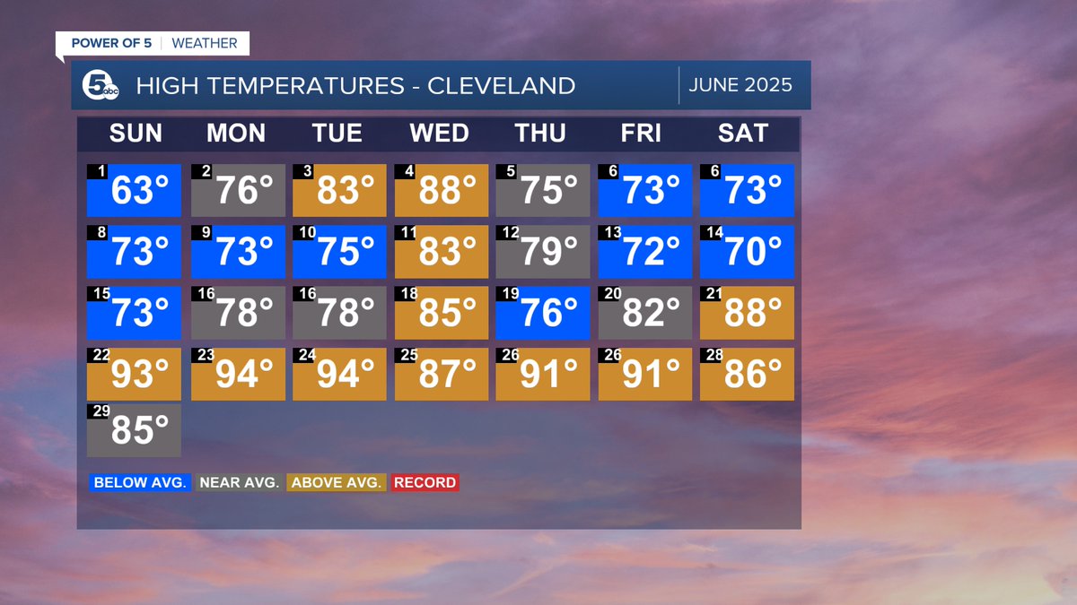
GOODBYE JUNE! It was another wet month with over 5 inches of rain in Cleveland which is more than 1 inch above average. It was also 1.4 degrees warmer than a typical June with 12 days above average, but there were also 10 days below average! Bottom line - A wild weather month!

GOODBYE JUNE! 
It was another wet month with over 5 inches of rain in Cleveland which is more than 1 inch above average. It was also 1.4 degrees warmer than a typical June with 12 days above average, but there were also 10 days below average! Bottom line - A wild weather month!
Katie McGraw (@katiemcgrawx) 's Twitter Profile Photo

RADAR UPDATE: [July 1 at 7:50 pm] Widely scattered storms continue to push to the south and east through our viewing area,. These storms have torrential rain, frequent lightning and gusty winds, but will exit NEO in the next hour or two. Then it will be much quieter!

RADAR UPDATE: [July 1 at 7:50 pm]
Widely scattered storms continue to push to the south and east through our viewing area,. These storms have torrential rain, frequent lightning and gusty winds, but will exit NEO in the next hour or two. Then it will be much quieter!
Katie McGraw (@katiemcgrawx) 's Twitter Profile Photo

HEADS UP! [Thursday, July 2 PR:45 pm] I am keeping an eye on a couple of storms across the lake coming from Canada. These look to weaken as they cross over the during the next few hours, but could still bring a few t-showers to our northern communities.

HEADS UP! [Thursday, July 2 <a href="/10/">PR</a>:45 pm] I am keeping an eye on a couple of storms across the lake coming from Canada. These look to weaken as they cross over the during the next few hours, but could still bring a few t-showers to our northern communities.
Katie McGraw (@katiemcgrawx) 's Twitter Profile Photo

FUN FACT! We're about 94.5 million miles from the Sun today — that's the farthest we get all year! You might think we'd be closer during summer, but seasons actually happen because of the tilt of Earth's axis, not how near or far we are from the Sun.

FUN FACT! We're about 94.5 million miles from the Sun today — that's the farthest we get all year! You might think we'd be closer during summer, but seasons actually happen because of the tilt of Earth's axis, not how near or far we are from the Sun.
Katie McGraw (@katiemcgrawx) 's Twitter Profile Photo

FOURTHCAST: Tomorrow looks great! It will be *mostly* dry with warm temps in the mid 80s and plenty of sun. A couple PM storms cannot be ruled out, most likely in our NW communities. Listen for thunder, but you have a MUCH better shot to be dry all day!

Katie McGraw (@katiemcgrawx) 's Twitter Profile Photo

Happy 4th of July!! Today has been fantastic and that looks to continue this evening. There is only the teeniest chance for a stray t-shower in our NW communities this evening. Otherwise, it will be dry and warm! Have a great night!

Katie McGraw (@katiemcgrawx) 's Twitter Profile Photo

😒 We are losing about 1 minute and 20 seconds of daylight every day in the middle of July. By the end of July, that speeds up to 2 minutes of daylight every day.

😒 

We are losing about 1 minute and 20 seconds of daylight every day in the middle of July. 

By the end of July, that speeds up to 2 minutes of daylight every day.