Sofia Lazar (@lazarsofia1) 's Twitter Profile
Sofia Lazar

@lazarsofia1

MSc in Water Resources💧@WaterResearchRU @Rhodes_Uni

Engineer in Structures Construction🏗️ @EnshBlida

#DataViz 📊 #GIS #R #Python🐍

ID: 1494334312438636549

linkhttps://www.linkedin.com/in/sofia-lazar-5926a4139/ calendar_today17-02-2022 15:34:16

686 Tweet

723 Followers

512 Following

Sofia Lazar (@lazarsofia1) 's Twitter Profile Photo

✨ From Map 📍 to Masterpiece 🖌️ I explored OpenCV in Python to transform maps into stunning pencil sketches! 🖼️ Here's #France 🇫🇷 as an example, with #Germany 🇩🇪, and #Spain 🇪🇸 also in the mix 💥 🌍 Art + Tech = Magic! #Python #OpenCV #GIS #Maps #DataVisualization #Europe

✨ From Map 📍 to Masterpiece 🖌️

I explored OpenCV in Python to transform maps into stunning pencil sketches! 🖼️ Here's #France 🇫🇷 as an example, with #Germany 🇩🇪, and #Spain 🇪🇸 also in the mix 💥

🌍 Art + Tech = Magic!

#Python #OpenCV #GIS #Maps #DataVisualization #Europe
Milos Makes Maps (@milosmakesmaps) 's Twitter Profile Photo

🌍 My final video of 2024 is here to teach you how to process Sentinel-2 satellite data and craft breathtaking 3D map animations with rayshader in R—just like the one of Colorado Springs below! 🎥 Watch the full tutorial here 👉🏻 youtu.be/X3I6G9ypk4w Happy New Year!

Sofia Lazar (@lazarsofia1) 's Twitter Profile Photo

🌍 From Maps to MOVES: My #Sentinel2 Glow-Up! ✨ 1️⃣ Mapped #Cambodia's forests 🇰🇭...lush vibes 🌳 2️⃣ Animated it like Milos Popovic (End of 2024) 3️⃣ Turned it into 🔥 #3D with #Sentinel2 data 🌿 Mapping is ALIVE! 🛰️ #Satellite data? Limitless slayyy #RGeek #RemoteSensing #R

Sofia Lazar (@lazarsofia1) 's Twitter Profile Photo

🚀 Wrapping up 2024 with #LandScan2023 magic! 🌍 Created stunning #3D #PopulationDensity maps for #France & #Austria using this incredible dataset Explore it yourself on #GoogleEarthEngine 🌐: gee-community-catalog.org/projects/lands… #DataViz #Geospatial #RGeek #Spatialmapping

🚀 Wrapping up 2024 with #LandScan2023 magic! 

🌍 Created stunning #3D #PopulationDensity maps for #France & #Austria using this incredible dataset

Explore it yourself on #GoogleEarthEngine 

🌐: gee-community-catalog.org/projects/lands… 

#DataViz #Geospatial #RGeek #Spatialmapping
Sofia Lazar (@lazarsofia1) 's Twitter Profile Photo

🌍✨ 1st month of 2025 🎯 Guess which country is the heart of Central Europe & home to the Danube River? 👏 You got it—Hungary! 🇭🇺 🌳 Forest types dominate the terrain, led by deciduous broadleaf forests. 💧 Rivers like the #TiszaRiver & #Danube steal the show! #Geography #R

🌍✨ 1st month of 2025

🎯 Guess which country is the heart of Central Europe & home to the Danube River?

👏 You got it—Hungary! 🇭🇺

🌳 Forest types dominate the terrain, led by deciduous broadleaf forests. 💧 Rivers like the #TiszaRiver & #Danube steal the show!

#Geography #R
Sofia Lazar (@lazarsofia1) 's Twitter Profile Photo

🗺️✨ Turning history into art! I transformed vintage 1967 maps of Switzerland 🇨🇭 & Hungary 🇭🇺 into stunning 3D visualizations. Topography meets technology bringing the past to life in a whole new dimension! 🌍 #RGeek #3DMapping #Cartography #VintageMaps

🗺️✨ Turning history into art! I transformed vintage 1967 maps of Switzerland 🇨🇭 & Hungary 🇭🇺 into stunning 3D visualizations. 

Topography meets technology bringing the past to life in a whole new dimension! 🌍 

#RGeek #3DMapping #Cartography #VintageMaps
Milos Makes Maps (@milosmakesmaps) 's Twitter Profile Photo

🔥 1/ Want to map and analyze the 2025 California wildfires? Here are my go-to datasets and tools, to track fire events, assess their impact, and create actionable maps to help with emergency planning. Let’s dive into how you can do it step by step. ⬇️

Julian Hoffmann Anton (@julian_h0ffmann) 's Twitter Profile Photo

Wishing a strong recovery to all those impacted by the devastating fires in Los Angeles. To provide some context, here’s a visualization I created last year showing the population density of Greater Los Angeles, including 2025 estimates.

Sofia Lazar (@lazarsofia1) 's Twitter Profile Photo

🌍✨ Explore this stunning 3D map of the Iberian Peninsula 🇪🇸🇵🇹 with a glimpse of North Algeria 🇩🇿, crafted by the #USSR in 1967! A true cartographic gem. 🗺️ #Spain #Portugal #NorthAfrica #3DMaps #Rgeek #VintageAtlas #GeographyNerd

🌍✨ Explore this stunning 3D map of the Iberian Peninsula 🇪🇸🇵🇹 with a glimpse of North Algeria 🇩🇿, crafted by the #USSR in 1967! A true cartographic gem. 🗺️

#Spain #Portugal #NorthAfrica #3DMaps #Rgeek #VintageAtlas #GeographyNerd
Sofia Lazar (@lazarsofia1) 's Twitter Profile Photo

THE CONGO BASIN VANISHING LIFELINE The #DRC rainforest is vanishing! 🌍 From 130.5 Mha in 1990 to 102.73 Mha in 2024. Degraded forests increased from 0.53 Mha to 12.78 Mha. Recovery? 3.7 Mha of secondary forests. #Deforestation #ClimateChange

THE CONGO BASIN VANISHING LIFELINE

The #DRC rainforest is vanishing! 🌍 From 130.5 Mha in 1990 to 102.73 Mha in 2024. Degraded forests increased from 0.53 Mha to 12.78 Mha. Recovery? 3.7 Mha of secondary forests.

#Deforestation #ClimateChange
Sofia Lazar (@lazarsofia1) 's Twitter Profile Photo

🇧🇷 Deforestation Alert: #Brazil's tropical moist forest loss hit 63.54 Mha by 2024, with regrowth lagging behind at 16.08 Mha. However, degradation is rising sharply, signaling ongoing ecosystem stress. Let's keep a close watch! #Deforestation #Rstats #ClimateChange #Conservation

Sofia Lazar (@lazarsofia1) 's Twitter Profile Photo

🐾 𝗭𝗼𝗼𝗺 𝗶𝗻𝘁𝗼 𝘁𝗵𝗲 𝘄𝗶𝗹𝗱! 𝖶𝖾 𝗆𝖺𝗉𝗉𝖾𝖽 𝖤𝖺𝗋𝗍𝗁'𝗌 𝟪𝟨𝟩 𝖾𝖼𝗈𝗋𝖾𝗀𝗂𝗈𝗇𝗌 𝗂𝗇 𝟥𝖣 𝖺𝗇𝖽 𝗀𝗎𝖾𝗌𝗌 𝗐𝗁𝖺𝗍? 🌳 𝟥𝟧% 𝗈𝖿 𝗍𝗁𝖾 𝖠𝗆𝖺𝗓𝗈𝗇’𝗌 𝖽𝗂𝗏𝖾𝗋𝗌𝗂𝗍𝗒 𝗌𝗂𝗍𝗌 𝗂𝗇 𝗍𝗁𝖾 𝖲𝖶 𝖠𝗆𝖺𝗓𝗈𝗇𝗂𝖺𝗇 𝖬𝗈𝗂𝗌𝗍 𝖥𝗈𝗋𝖾𝗌𝗍 𝖺𝗅𝗈𝗇𝖾! #R #3D

🐾 𝗭𝗼𝗼𝗺 𝗶𝗻𝘁𝗼 𝘁𝗵𝗲 𝘄𝗶𝗹𝗱!
𝖶𝖾 𝗆𝖺𝗉𝗉𝖾𝖽 𝖤𝖺𝗋𝗍𝗁'𝗌 𝟪𝟨𝟩 𝖾𝖼𝗈𝗋𝖾𝗀𝗂𝗈𝗇𝗌 𝗂𝗇 𝟥𝖣 𝖺𝗇𝖽 𝗀𝗎𝖾𝗌𝗌 𝗐𝗁𝖺𝗍?
🌳 𝟥𝟧% 𝗈𝖿 𝗍𝗁𝖾 𝖠𝗆𝖺𝗓𝗈𝗇’𝗌 𝖽𝗂𝗏𝖾𝗋𝗌𝗂𝗍𝗒 𝗌𝗂𝗍𝗌 𝗂𝗇 𝗍𝗁𝖾 𝖲𝖶 𝖠𝗆𝖺𝗓𝗈𝗇𝗂𝖺𝗇 𝖬𝗈𝗂𝗌𝗍 𝖥𝗈𝗋𝖾𝗌𝗍 𝖺𝗅𝗈𝗇𝖾!
#R #3D
Sofia Lazar (@lazarsofia1) 's Twitter Profile Photo

🌍 Iberia: Where the People Are 🇪🇸🇵🇹 Mapped at 30 arcsec resolution using GHSL: 🔴 Rural decline 🟡 Urban/coastal growth 🔵 Mountains & plains = uninhabited 👀 Who stays? Who leaves? Where’s the future? Inspired by a classic tutorial from Milos Popovic 🙌 #PopulationChange #R
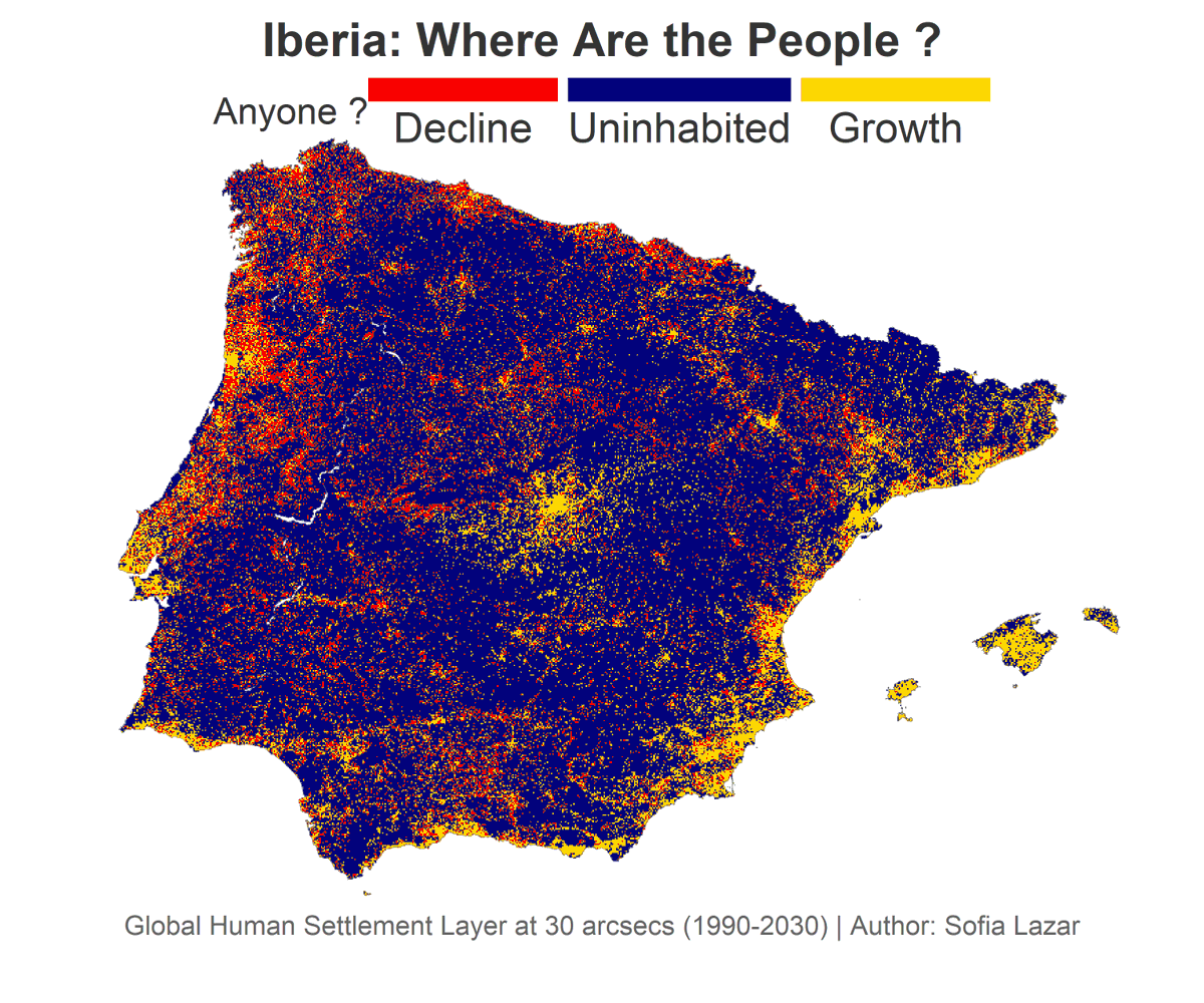
🌍 Iberia: Where the People Are 🇪🇸🇵🇹
Mapped at 30 arcsec resolution using GHSL:
🔴 Rural decline
🟡 Urban/coastal growth
🔵 Mountains & plains = uninhabited

👀 Who stays? Who leaves? Where’s the future?
Inspired by a classic tutorial from <a href="/milos_agathon/">Milos Popovic</a> 🙌
#PopulationChange #R
Sofia Lazar (@lazarsofia1) 's Twitter Profile Photo

🌍 𝗩𝗶𝘀𝘂𝗮𝗹𝗶𝘇𝗶𝗻𝗴 𝗙𝗼𝗿𝗲𝘀𝘁 𝗠𝗮𝗻𝗮𝗴𝗲𝗺𝗲𝗻𝘁 𝗶𝗻 𝗜𝗯𝗲𝗿𝗶𝗮 𝗳𝗿𝗼𝗺 𝗨𝗻𝗱𝗶𝘀𝘁𝘂𝗿𝗯𝗲𝗱 𝗣𝗲𝗮𝗸𝘀 𝘁𝗼 𝗜𝗻𝘁𝗲𝗻𝘀𝗶𝘃𝗲 𝗣𝗹𝗮𝗶𝗻𝘀 🌲🇪🇸 🇵🇹 #𝖥𝗈𝗋𝖾𝗌𝗍𝗋𝗒 #𝖱𝖾𝗆𝗈𝗍𝖾𝖲𝖾𝗇𝗌𝗂𝗇𝗀 #𝖲𝗎𝗌𝗍𝖺𝗂𝗇𝖺𝖻𝗂𝗅𝗂𝗍𝗒 #𝖫𝖺𝗇𝖽𝗌𝖼𝖺𝗉𝖾𝖤𝖼𝗈𝗅𝗈𝗀𝗒 #R

🌍 𝗩𝗶𝘀𝘂𝗮𝗹𝗶𝘇𝗶𝗻𝗴 𝗙𝗼𝗿𝗲𝘀𝘁 𝗠𝗮𝗻𝗮𝗴𝗲𝗺𝗲𝗻𝘁 𝗶𝗻 𝗜𝗯𝗲𝗿𝗶𝗮 𝗳𝗿𝗼𝗺 𝗨𝗻𝗱𝗶𝘀𝘁𝘂𝗿𝗯𝗲𝗱 𝗣𝗲𝗮𝗸𝘀 𝘁𝗼 𝗜𝗻𝘁𝗲𝗻𝘀𝗶𝘃𝗲 𝗣𝗹𝗮𝗶𝗻𝘀 🌲🇪🇸 🇵🇹

#𝖥𝗈𝗋𝖾𝗌𝗍𝗋𝗒 #𝖱𝖾𝗆𝗈𝗍𝖾𝖲𝖾𝗇𝗌𝗂𝗇𝗀 #𝖲𝗎𝗌𝗍𝖺𝗂𝗇𝖺𝖻𝗂𝗅𝗂𝗍𝗒 #𝖫𝖺𝗇𝖽𝗌𝖼𝖺𝗉𝖾𝖤𝖼𝗈𝗅𝗈𝗀𝗒 #R
Sofia Lazar (@lazarsofia1) 's Twitter Profile Photo

🗺️🌲 𝗠𝗮𝗽𝗽𝗶𝗻𝗴 𝗙𝗼𝗿𝗲𝘀𝘁 𝗠𝗮𝗻𝗮𝗴𝗲𝗺𝗲𝗻𝘁 𝗶𝗻 𝟯𝗗: 𝗔 𝗟𝗼𝗼𝗸 𝗮𝘁 𝗙𝗿𝗮𝗻𝗰𝗲 🇫🇷 A 𝗌𝗍𝗎𝖽𝗒 “𝗠𝗮𝗽𝗽𝗶𝗻𝗴 𝗳𝗼𝗿𝗲𝘀𝘁 𝗺𝗮𝗻𝗮𝗴𝗲𝗺𝗲𝗻𝘁 𝗿𝗲𝗴𝗶𝗺𝗲𝘀 𝗶𝗻 𝗘𝘂𝗿𝗼𝗽𝗲” 𝖻𝗒 𝖵𝗋𝗂𝗃𝖾 𝖴𝗇𝗂𝗏𝖾𝗋𝗌𝗂𝗍𝖾𝗂𝗍 𝖠𝗆𝗌𝗍𝖾𝗋𝖽𝖺𝗆 #R #𝖥𝗈𝗋𝖾𝗌𝗍𝗋𝗒

🗺️🌲 𝗠𝗮𝗽𝗽𝗶𝗻𝗴 𝗙𝗼𝗿𝗲𝘀𝘁 𝗠𝗮𝗻𝗮𝗴𝗲𝗺𝗲𝗻𝘁 𝗶𝗻 𝟯𝗗: 𝗔 𝗟𝗼𝗼𝗸 𝗮𝘁 𝗙𝗿𝗮𝗻𝗰𝗲 🇫🇷

A 𝗌𝗍𝗎𝖽𝗒 “𝗠𝗮𝗽𝗽𝗶𝗻𝗴 𝗳𝗼𝗿𝗲𝘀𝘁 𝗺𝗮𝗻𝗮𝗴𝗲𝗺𝗲𝗻𝘁 𝗿𝗲𝗴𝗶𝗺𝗲𝘀 𝗶𝗻 𝗘𝘂𝗿𝗼𝗽𝗲” 𝖻𝗒 𝖵𝗋𝗂𝗃𝖾 𝖴𝗇𝗂𝗏𝖾𝗋𝗌𝗂𝗍𝖾𝗂𝗍 𝖠𝗆𝗌𝗍𝖾𝗋𝖽𝖺𝗆 

#R #𝖥𝗈𝗋𝖾𝗌𝗍𝗋𝗒
Sofia Lazar (@lazarsofia1) 's Twitter Profile Photo

Iberia, 2024 🇪🇸 🇵🇹 Not just land — a patchwork of 💧water, 🌾crops, 🏙️cities, and 🌳wild green This is how we’re using space. This is what we’re leaving behind ‼️ 🔍 Zoom in...........Look closer 👀 #LandUse #Iberia #RemoteSensing #Rstats #Spain #Portugal #geospatial #Iberia

Iberia, 2024 🇪🇸 🇵🇹

Not just land — a patchwork of 💧water, 🌾crops, 🏙️cities, and 🌳wild green

This is how we’re using space. This is what we’re leaving behind ‼️

🔍 Zoom in...........Look closer 👀

#LandUse #Iberia #RemoteSensing #Rstats #Spain #Portugal #geospatial #Iberia
Sofia Lazar (@lazarsofia1) 's Twitter Profile Photo

🇫🇷 Où bat le cœur démographique de la France ? Déclin 🟥, croissance 🟨, vide 🟦. Un regard pixelisé sur 40 ans d’évolution humaine (1990–2030) 📊 #GHSL #DataViz #France #Cartographie #Urbanisation #Rstats #Europe

🇫🇷 Où bat le cœur démographique de la France ?

Déclin 🟥, croissance 🟨, vide 🟦.

Un regard pixelisé sur 40 ans d’évolution humaine (1990–2030) 📊

#GHSL #DataViz #France #Cartographie #Urbanisation #Rstats #Europe
Sofia Lazar (@lazarsofia1) 's Twitter Profile Photo

🔥 Hot spots, dry drops 📍 Iberian Peninsula Where people live ≠ where water falls 👉 Better take a look at Milos Makes Maps tuts, you don’t know what you’re missing.......seriously 🎯 #DataViz #ClimateResilience #Geospatia #Rstats #Spain #Portugal #Iberia #Remotesensing
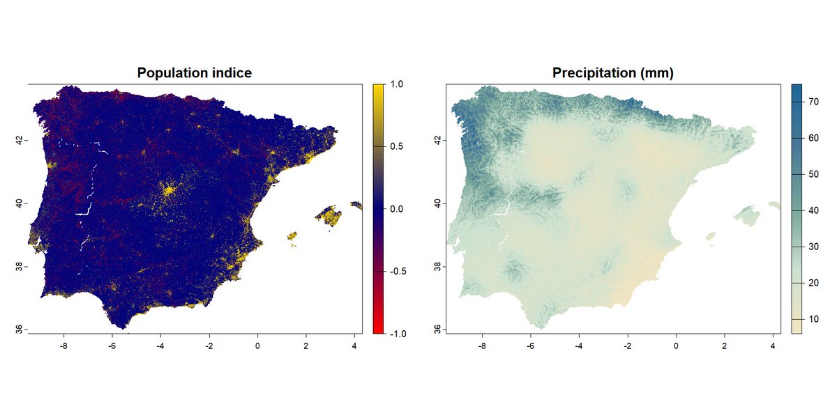
🔥 Hot spots, dry drops

📍 Iberian Peninsula

Where people live ≠ where water falls

👉 Better take a look at <a href="/milosmakesmaps/">Milos Makes Maps</a> tuts, you don’t know what you’re missing.......seriously 🎯

#DataViz #ClimateResilience #Geospatia #Rstats #Spain #Portugal #Iberia #Remotesensing
Sofia Lazar (@lazarsofia1) 's Twitter Profile Photo

🚨 Ever seen #UK railways breathe over terrain? 😎Rendered in R.......Rail veins in red #London pulses, the Highlands whisper #OSM + #rayshader = 🔥 Just in case you want to learn HOW? 👉👉👉Milos Makes Maps #DataViz #Rstats #England #Wales #Scotland
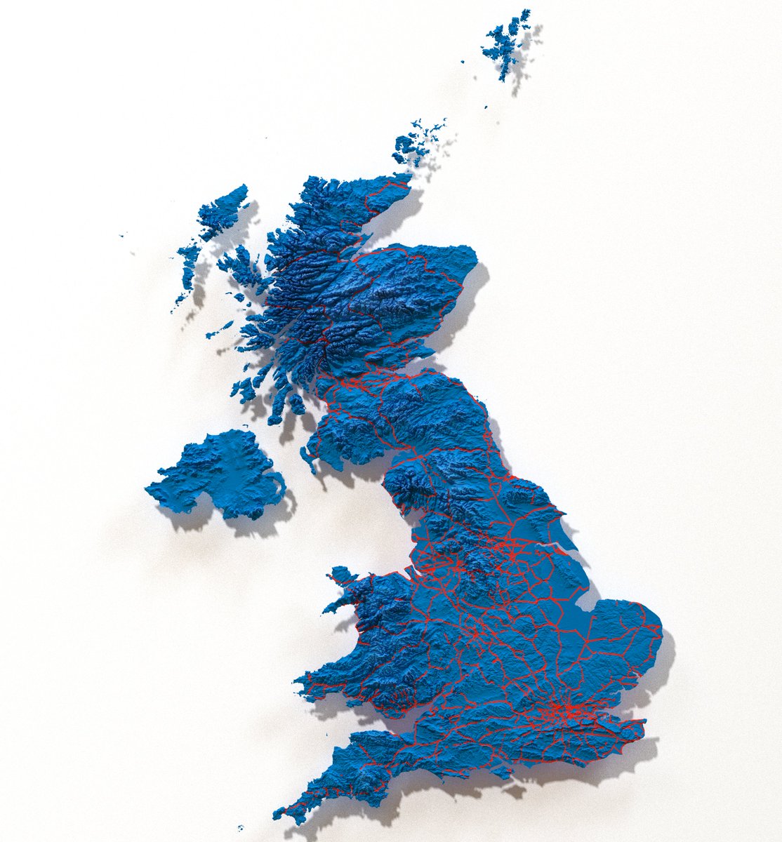
🚨 Ever seen #UK railways breathe over terrain?

😎Rendered in R.......Rail veins in red 

#London pulses, the Highlands whisper

#OSM + #rayshader = 🔥

 Just in case you want to learn HOW? 👉👉👉<a href="/milosmakesmaps/">Milos Makes Maps</a> 

#DataViz #Rstats #England #Wales #Scotland
Sofia Lazar (@lazarsofia1) 's Twitter Profile Photo

🚨🚆 3D RAIL MADNESS ACROSS 🇺🇸 🚆🚨 Just mapped the entire US rail network draped over 3D terrain and YES, it’s as wild as it sounds🧠💥 🥸 Inspired by the wizardry of Milos Makes Maps #DataViz #rstats #Cartography #OpenData #Rstats #Infrastructure #USA #Railways
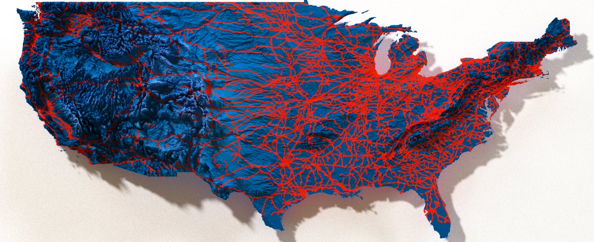
🚨🚆 3D RAIL MADNESS ACROSS 🇺🇸 🚆🚨

Just mapped the entire US rail network draped over 3D terrain and YES, it’s as wild as it sounds🧠💥

🥸 Inspired by the wizardry of <a href="/milosmakesmaps/">Milos Makes Maps</a> 

#DataViz #rstats #Cartography #OpenData #Rstats #Infrastructure #USA #Railways