Landscape Geoinformatics
@lgeoinformatics
Our workgroup focuses on sustainable landscape planning and resource management using geospatial analysis, machine learning, and modeling. Lead by @evelynuuemaa
ID: 1177683182461820929
https://landscape-geoinformatics.ut.ee 27-09-2019 20:35:52
297 Tweet
979 Followers
71 Following
 on Twitter photo Last week, we joined the <a href=\"/Hytruck/\">Hytruck</a> project quarterly meeting in Riga, where experts in economics, transportation and hydrogen discussed the future of hydrogen-powered freight transport!
We got great feedback on our work and explored hydrogen-powered public transport in Riga! 🚌")
We had an awesome opportunity to host Ujaval Gandhi University of Tartu last week and teaching in our GEM MSc programme #remotesensing with #GEE🛰️🌍 and advising our team on large-scale #spatial analysis 🙌
 's Twitter Profile Photo")
📰 Reflections from Evelyn | @[email protected] on how satellite & open data fuel innovation! 🌍 🛰️ New models from research, like those at our Centre of Excellence, help to unlock full potential of satellite data. Read more bit.ly/3CnGQ2Q 📷 SCANPIX
 on Twitter photo 📰 Reflections from <a href=\"/evelynuuemaa/\">Evelyn | @evelynuuemaa@fosstodon.org</a> on how satellite & open data fuel innovation! 🌍
🛰️ New models from research, like those at our Centre of Excellence, help to unlock full potential of satellite data.
Read more bit.ly/3CnGQ2Q
📷 SCANPIX")
We are excited to contribute to the Open Geospatial: OGC #DGGS API standard through our novel DGGS #datacube European Research Council (ERC) project #WaterSmartLand 💦🌍Interoperabitlity is crucial, and we presented our open-source DGGS server at the 130th Open Geospatial: OGC meeting in Seoul!
 on Twitter photo We are excited to contribute to the <a href=\"/opengeospatial/\">Open Geospatial: OGC</a> #DGGS API standard through our novel DGGS #datacube <a href=\"/ERC_Research/\">European Research Council (ERC)</a> project #WaterSmartLand 💦🌍Interoperabitlity is crucial, and we presented our open-source DGGS server at the 130th <a href=\"/opengeospatial/\">Open Geospatial: OGC</a> meeting in Seoul!")
Last Thursday, we attended the Estonian Remote Sensing Day gathering of experts and enthusiasts exploring remote sensing innovations at @tartuobs ! 🛰️📡 💬 Our team member Holger Virro presented on using deep learning to identify drainage ditches from lidar data.
 on Twitter photo Last Thursday, we attended the Estonian Remote Sensing Day gathering of experts and enthusiasts exploring remote sensing innovations at @tartuobs ! 🛰️📡
💬 Our team member <a href=\"/holgervirro/\">Holger Virro</a> presented on using deep learning to identify drainage ditches from lidar data.")
 on Twitter photo We have Christmas Sweater office day today 🤪🎄🧑🎄lots of cool/funny/weird sweaters and three best were awarded big Grinch Christmas sweater gingerbread 😅")
🌍 In our European Research Council (ERC) funded WaterSmartLand (water-smart-land.eu) project, we’re building an environmental datacube using DGGS tech. On 17 Dec, Alexander Kmoch | @[email protected] visited #ESA HQ in Paris 🇫🇷 to discuss DGGS and share insights with science and technology staff. 🤝
 on Twitter photo 🌍 In our <a href=\"/ERC_Research/\">European Research Council (ERC)</a> funded WaterSmartLand (water-smart-land.eu) project, we’re building an environmental datacube using DGGS tech.
On 17 Dec, <a href=\"/allixender/\">Alexander Kmoch | @allixender@fosstodon.org</a> visited #ESA HQ in Paris 🇫🇷 to discuss DGGS and share insights with science and technology staff. 🤝")
🌍 Last week, Marta Jemeljanova, Alexander Kmoch | @[email protected] & Evelyn | @[email protected] visited @AaltoGeoinfo & FGI, NLS's Geoinformatics Dept. 🤝 Excited about collaboration between Digital Waters Flagship & ERC #WaterSmartLand, and sharing insights on teaching #FOSS4G. Thanks a lot for having us! 🌊
 on Twitter photo 🌍 Last week, <a href=\"/M_Jemeljanova/\">Marta Jemeljanova</a>, <a href=\"/allixender/\">Alexander Kmoch | @allixender@fosstodon.org</a> & <a href=\"/evelynuuemaa/\">Evelyn | @evelynuuemaa@fosstodon.org</a> visited @AaltoGeoinfo & <a href=\"/fgi_nls/\">FGI, NLS</a>'s Geoinformatics Dept. 🤝
Excited about collaboration between Digital Waters Flagship & ERC #WaterSmartLand, and sharing insights on teaching #FOSS4G.
Thanks a lot for having us! 🌊")
 's Twitter Profile Photo")
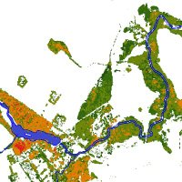
🌍 We're building a #datacube Landscape Geoinformatics to integrate spatial data with varying resolutions. Resampling is key for aligning datasets with different resolutions, coordinate systems, or extents. Check out our quick cheat sheet for resampling tips! Have any suggestions?💬
 on Twitter photo 🌍 We're building a #datacube <a href=\"/LGeoinformatics/\">Landscape Geoinformatics</a> to integrate spatial data with varying resolutions.
Resampling is key for aligning datasets with different resolutions, coordinate systems, or extents.
Check out our quick cheat sheet for resampling tips!
Have any suggestions?💬")
 's Twitter Profile Photo")
Our latest research has been published in Environmental Monitoring and Assessment from Springer Nature We analyzed how land cover influences air quality in southern Ecuador using Sentineldata. Thanks to my co-authors Evelyn | @[email protected],Szilard and Danilo Read: tinyurl.com/lulc-air
 's Twitter Profile Photo")
We have just opened an exciting PhD position in GeoAI & LLMs and are looking for motivated PhD candidates! The PhD will be supervised by me and Nico Van de Weghe from the GeoAI Research Center, Ghent University. Apply by March 2nd, 2025 from here (+ details): aalto.fi/en/open-positi…
 on Twitter photo We have just opened an exciting PhD position in GeoAI & LLMs and are looking for motivated PhD candidates! The PhD will be supervised by me and <a href=\"/NicoWeghe/\">Nico Van de Weghe</a> from the GeoAI Research Center, Ghent University.
Apply by March 2nd, 2025 from here (+ details): aalto.fi/en/open-positi…")
 on Twitter photo Last week, our team went on a writing retreat to focus on crafting scientific articles. 📝✨
The days were filled with deep work and collaboration. We also shared valuable tips and tricks on scientific writing tools and methods.💡
Also, we enjoyed quality time as a team! 👥")
 on Twitter photo We were really happy to be present at the annual Delta Career Day yesterday! 🌐
We met with so many eager students and also had great conversations with them! 🙌✨
It was great to see such high interest from the participants towards us! 👏
#geoinformatics #unitartudelta")
 on Twitter photo Friday evening chill in our new #geoinformatics corner <a href=\"/unitartu/\">University of Tartu</a> 😎")
 on Twitter photo We presented the initial Estonian Environmental Data Cube portal (geokuup.ee ) at the Estonian Spatial Planning Conference! This portal, developed under #FutureScapes & #WaterSmartLand (funded by #ETAG 🔬), offers structured environmental data 📊 for spatial planning")