Sᴏᴜᴛʜᴇʀɴ ᴇɴɢʟᴀɴᴅ ᴡᴇᴀᴛʜᴇʀ (@londonsnowwatch) 's Twitter Profile
Sᴏᴜᴛʜᴇʀɴ ᴇɴɢʟᴀɴᴅ ᴡᴇᴀᴛʜᴇʀ

@londonsnowwatch

Short, medium & long range forecasts for southern England. No hype, no like/rt bait. Snow watch Nov➡March, weather all year round

ID: 300181817

calendar_today17-05-2011 10:26:14

85,85K Tweet

12,12K Followers

194 Following

Sᴏᴜᴛʜᴇʀɴ ᴇɴɢʟᴀɴᴅ ᴡᴇᴀᴛʜᴇʀ (@londonsnowwatch) 's Twitter Profile Photo

A reminder & update on the winds Mon/Tues Gusting 30-40mph widely. Up to 45 mph locally And Tuesday, some southern coastal counties could see 40-50mph gusts Unusual for summer Remember if plants have gotten lanky with warm weather they may need staking today to avoid damage

Sᴏᴜᴛʜᴇʀɴ ᴇɴɢʟᴀɴᴅ ᴡᴇᴀᴛʜᴇʀ (@londonsnowwatch) 's Twitter Profile Photo

Been keeping an eye on Friday eve/night for poss heavy showers/storms moving up through e/se parts of the region And possibly more widespread showers further west into Saturday Uncertain one but the chance is there 👀 (This is not a forecast at this stage)

Been keeping an eye on Friday eve/night for poss heavy showers/storms moving up through e/se parts of the region

And possibly more widespread showers further west into Saturday

Uncertain one but the chance is there 👀

(This is not a forecast at this stage)
Sᴏᴜᴛʜᴇʀɴ ᴇɴɢʟᴀɴᴅ ᴡᴇᴀᴛʜᴇʀ (@londonsnowwatch) 's Twitter Profile Photo

That's sort of subjective. For me we've had the worst part of summer 😂 But if the question is do i think there will be further spells of warmth and heat this summer, then yes I think that's very likely

Sᴏᴜᴛʜᴇʀɴ ᴇɴɢʟᴀɴᴅ ᴡᴇᴀᴛʜᴇʀ (@londonsnowwatch) 's Twitter Profile Photo

Will issue the forecast later ☔ ⚡ Whilst there might be a few storms within, the main focus will be on a fairly large area seeing pulses of torrential rain falling on rock hard ground and the subsequent risk of serious flooding

Sᴏᴜᴛʜᴇʀɴ ᴇɴɢʟᴀɴᴅ ᴡᴇᴀᴛʜᴇʀ (@londonsnowwatch) 's Twitter Profile Photo

I've just hit 30c for the 12th time this summer (6 times in June and so far 6 times in July) Wanstead weather Elsewhere in the region, it's high 20's widely for central and eastern parts but much fresher in the sw
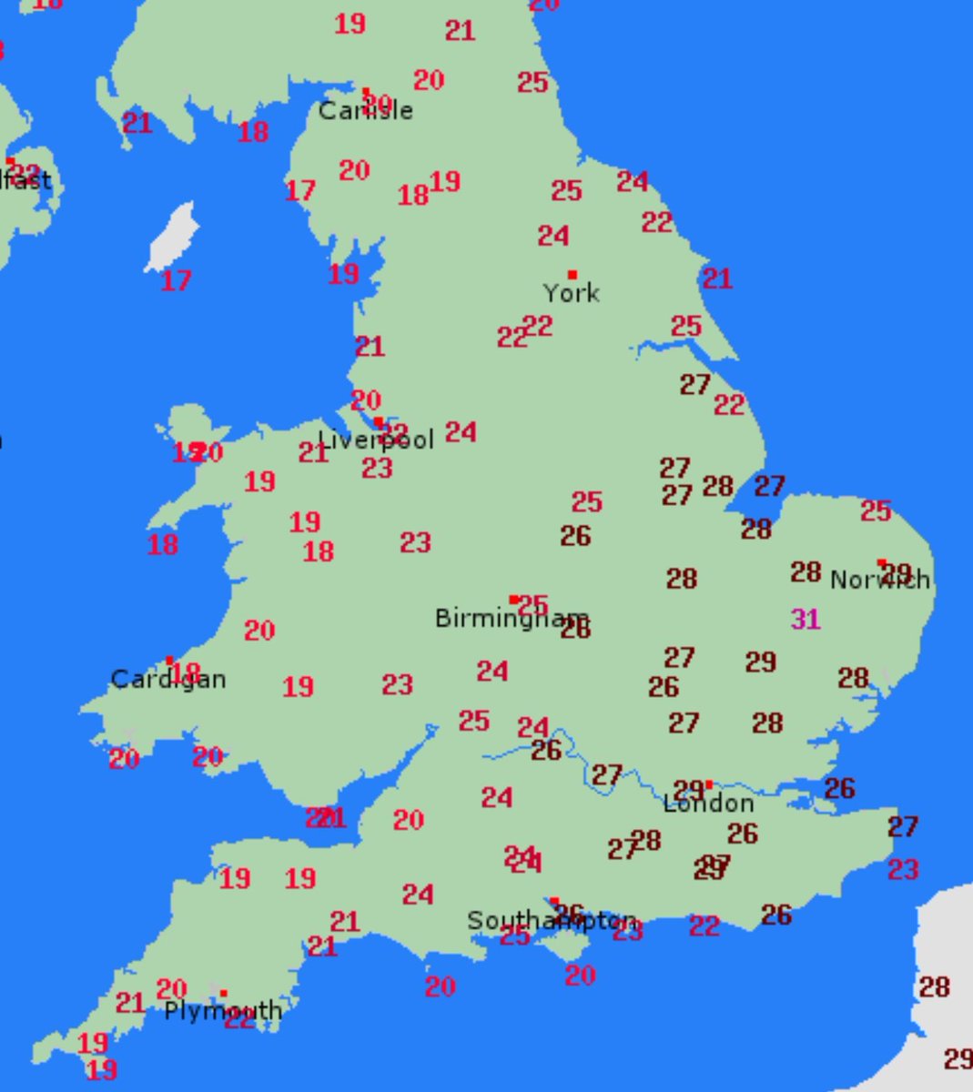
I've just hit 30c for the 12th time this summer (6 times in June and so far 6 times in July) <a href="/wanstead_meteo/">Wanstead weather</a>

Elsewhere in the region, it's high 20's widely for central and eastern parts but much fresher in the sw
Sᴏᴜᴛʜᴇʀɴ ᴇɴɢʟᴀɴᴅ ᴡᴇᴀᴛʜᴇʀ (@londonsnowwatch) 's Twitter Profile Photo

Storm/heavy showers forecast low confidence when stuff is modelled to come up from France Pulses of intense showers will move nw from the se from late eve Rain is main headline, with potential for serious flooding some embedded storms may bring brief gusty winds, hail &⚡

Storm/heavy showers forecast

low confidence when stuff is modelled to come up from France

Pulses of intense showers will move nw from the se from late eve

Rain is main headline, with potential for serious flooding

some embedded storms may bring brief gusty winds, hail &amp;⚡
Sᴏᴜᴛʜᴇʀɴ ᴇɴɢʟᴀɴᴅ ᴡᴇᴀᴛʜᴇʀ (@londonsnowwatch) 's Twitter Profile Photo

Into Saturday afternoon, some storms may break out in the east/se Hit and miss as always Where you do catch one, it could be briefly torrential with hail, lightning and gusty winds

Into Saturday afternoon, some storms may break out in the east/se

Hit and miss as always

Where you do catch one, it could be briefly torrential with hail, lightning and gusty winds
Sᴏᴜᴛʜᴇʀɴ ᴇɴɢʟᴀɴᴅ ᴡᴇᴀᴛʜᴇʀ (@londonsnowwatch) 's Twitter Profile Photo

The forecast is now live so if you are radar watching here's the expected tracks of the stuff in the Channel and across N France Very roughly speaking, of course Bring on the rain! ☔ (⚡)

The forecast is now live so if you are radar watching here's the expected tracks of the stuff in the Channel and across N France

Very roughly speaking, of course

Bring on the rain! ☔ (⚡)
Sᴏᴜᴛʜᴇʀɴ ᴇɴɢʟᴀɴᴅ ᴡᴇᴀᴛʜᴇʀ (@londonsnowwatch) 's Twitter Profile Photo

More widespread rain now pushing into the south As expected, it's mostly just rain and not storms We'll see what happens once the sun rises regarding the storm risk. I have a feeling it may get lively into the afternoon (see separate forecast from Fri eve)

Sᴏᴜᴛʜᴇʀɴ ᴇɴɢʟᴀɴᴅ ᴡᴇᴀᴛʜᴇʀ (@londonsnowwatch) 's Twitter Profile Photo

Passed the inch mark here with 26.4mm The stuff south of my location you see on the attached radar image is likely to intensify into this afternoon And small chance it'll become electric as per the forecast quoted below (We'll probably need some sunshine for storms to pop)

Sᴏᴜᴛʜᴇʀɴ ᴇɴɢʟᴀɴᴅ ᴡᴇᴀᴛʜᴇʀ (@londonsnowwatch) 's Twitter Profile Photo

More heavy showers Sunday Blue area is where highest instability combines with strongest wind shear. Though this will probably become confined to only west midlands by afternoon Heavy showers may result in flash flooding If you catch a storm: hail, lightning & gusty winds poss

More heavy showers Sunday

Blue area is where highest instability combines with strongest wind shear. Though this will probably become confined to only west midlands by afternoon

Heavy showers may result in flash flooding

If you catch a storm: hail, lightning &amp; gusty winds poss
Sᴏᴜᴛʜᴇʀɴ ᴇɴɢʟᴀɴᴅ ᴡᴇᴀᴛʜᴇʀ (@londonsnowwatch) 's Twitter Profile Photo

39.9mm is my wettest day since 23rd September 2024 when I recorded 56.6mm It's the wettest July day I've ever recorded, exceeding the previous wettest which was 12th July 2021 with 38.1mm

39.9mm is my wettest day since 23rd September 2024 when I recorded 56.6mm

It's the wettest July day I've ever recorded, exceeding the previous wettest which was 12th July 2021 with 38.1mm
Sᴏᴜᴛʜᴇʀɴ ᴇɴɢʟᴀɴᴅ ᴡᴇᴀᴛʜᴇʀ (@londonsnowwatch) 's Twitter Profile Photo

Back to this afternoon, we do now have sunshine spreading up from the south coast remains a small chance that sunshine will send those air parcels soaring & tap into the instability that is present in green shading on forecast below One has already popped up over Deal, Kent ⚡

Sᴏᴜᴛʜᴇʀɴ ᴇɴɢʟᴀɴᴅ ᴡᴇᴀᴛʜᴇʀ (@londonsnowwatch) 's Twitter Profile Photo

We've tried every wind direction in recent days but it seems to be perpetually humid inland Giving a northerly a go today, but the dew point still reached mid teens Some milder nights coming up despite maxes low 20's high 20's on Friday before dropping back low 20's over wkend

We've tried every wind direction in recent days but it seems to be perpetually humid inland

Giving a northerly a go today, but the dew point still reached mid teens

Some milder nights coming up despite maxes low 20's

high 20's on Friday before dropping back low 20's over wkend
Sᴏᴜᴛʜᴇʀɴ ᴇɴɢʟᴀɴᴅ ᴡᴇᴀᴛʜᴇʀ (@londonsnowwatch) 's Twitter Profile Photo

A high of 26.6c here so far today But yesterday was an anomalous one My high of 19.8c was only the 6th day this summer I've recorded a max below 20c The other 5 times were all in the first 8 days of June Wanstead weather It was still humid, of course
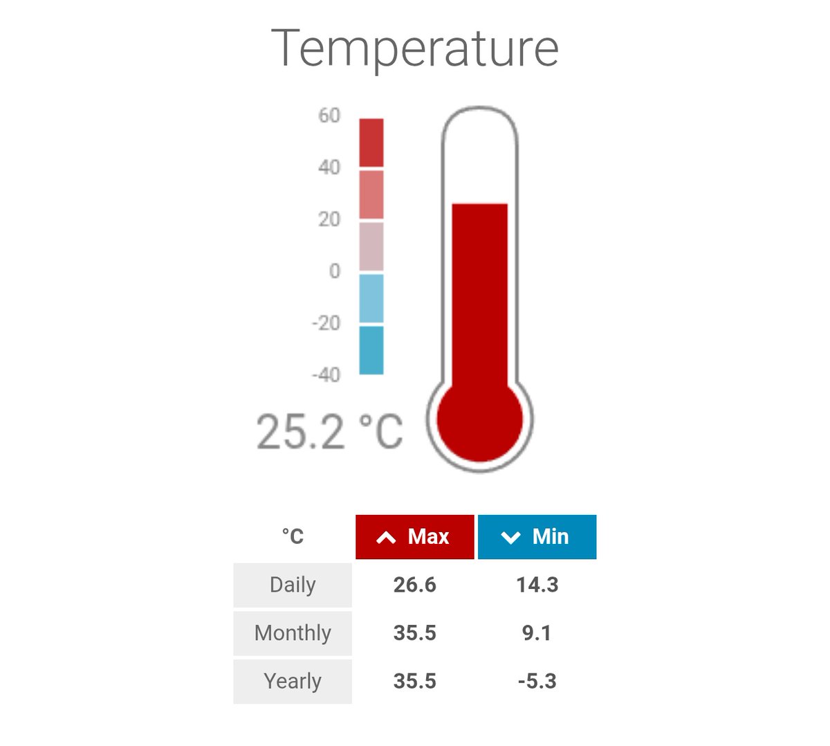
A high of 26.6c here so far today

But yesterday was an anomalous one

My high of 19.8c was only the 6th day this summer I've recorded a max below 20c

The other 5 times were all in the first 8 days of June <a href="/wanstead_meteo/">Wanstead weather</a>

It was still humid, of course