Maxar Technologies (@maxar) 's Twitter Profile
Maxar Technologies

@maxar

Maxar is a leading provider of secure, precise geospatial insights. Our products and services empower users to achieve mission success on Earth and in space.

ID: 17027323

linkhttps://www.maxar.com calendar_today28-10-2008 19:49:49

11,11K Tweet

123,123K Followers

844 Following

Maxar Technologies (@maxar) 's Twitter Profile Photo

We're excited to share that Todd Surdey joins Maxar Intelligence as SVP & GM of Enterprise, bringing decades of experience from Palo Alto Networks, VMware, Google, and Salesforce. #Maxar #GeospatialAI #Leadership

We're excited to share that Todd Surdey joins Maxar Intelligence as SVP & GM of Enterprise, bringing decades of experience from Palo Alto Networks, VMware, Google, and Salesforce.

#Maxar #GeospatialAI #Leadership
Maxar Technologies (@maxar) 's Twitter Profile Photo

Need it now? We’ve got you. With WorldView Tasking, we've doubled fulfillment rates over the past year—because when you’re fighting wildfires, tracking threats or racing storms, success means everything. Three flexible options: 🔴 Single Shot – Guaranteed collection on your

Maxar Technologies (@maxar) 's Twitter Profile Photo

Shape the future with your impact. Maxar Intelligence is a leading provider of secure, precise geospatial insights, operating the most advanced commercial Earth observation constellation. Explore career opportunities where you can truly make a difference. Ready to learn more

Shape the future with your impact. Maxar Intelligence is a leading provider of secure, precise geospatial insights, operating the most advanced commercial Earth observation constellation. Explore career opportunities where you can truly make a difference.

Ready to learn more
Maxar Technologies (@maxar) 's Twitter Profile Photo

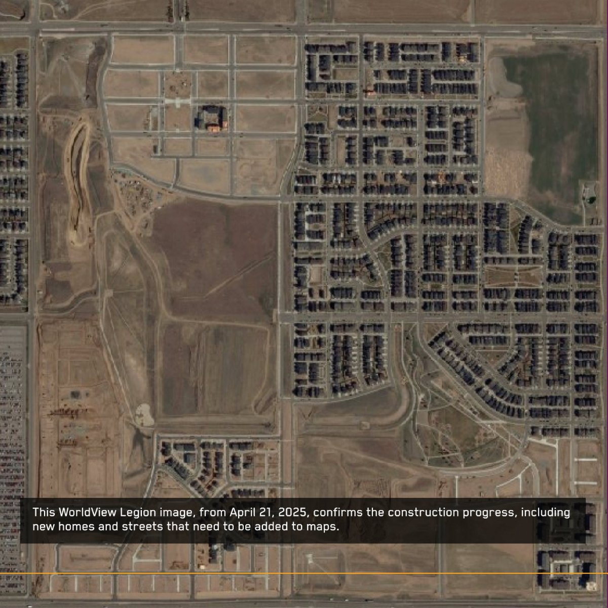
🌍 Maps are only as useful as they are accurate—and the world is changing fast. Our Building and Road Change product uses AI to detect new construction globally, delivering fresh vector data every 5 days. Faster updates, smarter mapping. Learn how we're moving toward a future

🌍 Maps are only as useful as they are accurate—and the world is changing fast.

Our Building and Road Change product uses AI to detect new construction globally, delivering fresh vector data every 5 days. Faster updates, smarter mapping.

Learn how we're moving toward a future
Maxar Technologies (@maxar) 's Twitter Profile Photo

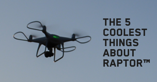
Excited for JNC 2025! Join us at Booth #431 for live Raptor demos—our game-changing software for drone navigation in GPS-denied environments.

Excited for JNC 2025! Join us at Booth #431 for live Raptor demos—our game-changing software for drone navigation in GPS-denied environments.
Maxar Technologies (@maxar) 's Twitter Profile Photo

Maxar and Saab have announced a strategic partnership to accelerate Europe’s space-based defense capabilities. By integrating Maxar’s satellite imagery and global 3D terrain with Saab’s advanced systems, the two will deliver next-gen C5ISR and resilient, GPS-free drone

Maxar and Saab have announced a strategic partnership to accelerate Europe’s space-based defense capabilities. By integrating Maxar’s satellite imagery and global 3D terrain with Saab’s advanced systems, the two will deliver next-gen C5ISR and resilient, GPS-free drone
Maxar Technologies (@maxar) 's Twitter Profile Photo

🍎 We're heading to NYC for #EOSummit! Stuart Fleming speaks June 11 on how Maxar’s new site monitoring solution combines satellite imagery + analytics to deliver insights at scale for the energy industry. Meet the team, join our reception and get a sneak peek:

🍎 We're heading to NYC for #EOSummit!

Stuart Fleming speaks June 11 on how Maxar’s new site monitoring solution combines satellite imagery + analytics to deliver insights at scale for the energy industry.

Meet the team, join our reception and get a sneak peek:
Maxar Technologies (@maxar) 's Twitter Profile Photo

Energy companies invest significant resources to identify and develop new locations for their operations. In today’s blog post, we detail how our geospatial insights can inform each part of the process: blog.maxar.com/earth-intellig… ▶️: This timelapse video shows the development of a

Maxar Technologies (@maxar) 's Twitter Profile Photo

Cleared and looking for your next mission? Join Maxar at the Cleared Women Career Fair on June 11, 12–3 p.m. EDT. 💬 Chat with recruiters 🌍 Explore career paths 🛰 Support critical missions We’re hiring. Let’s connect. 🔗:about.clearancejobs.com/candidates/car… #ClearedWomen

Cleared and looking for your next mission? Join Maxar at the Cleared Women Career Fair on June 11, 12–3 p.m. EDT.

💬 Chat with recruiters
🌍 Explore career paths
🛰 Support critical missions
We’re hiring. Let’s connect.

🔗:about.clearancejobs.com/candidates/car…

 #ClearedWomen
Maxar Technologies (@maxar) 's Twitter Profile Photo

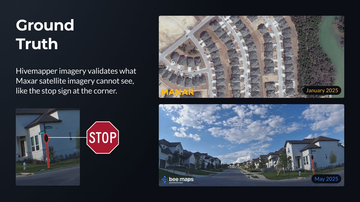
Austin is growing fast—10K+ new homes a year—and outdated maps can’t keep up. We tested a faster update method with Bee Maps (powered by Hivemapper) using Maxar satellite change detection, street-level bursts and fresh imagery. 80% of changes validated. Smarter maps,

Austin is growing fast—10K+ new homes a year—and outdated maps can’t keep up.

We tested a faster update method with <a href="/TryBeeMaps/">Bee Maps</a> (powered by <a href="/Hivemapper/">Hivemapper</a>) using Maxar satellite change detection, street-level bursts and fresh imagery.

80% of changes validated.

Smarter maps,
Maxar Technologies (@maxar) 's Twitter Profile Photo

This Pride Month, we celebrate the strength, joy and impact of the LGBTQ+ community—at Maxar and beyond. 🌈 Below: Harvey Milk Plaza in SF’s Castro District, seen by our WorldView Legion satellite. A symbol of activism, progress and Pride—past, present and future. #PrideMonth

This Pride Month, we celebrate the strength, joy and impact of the LGBTQ+ community—at Maxar and beyond. 🌈

Below: Harvey Milk Plaza in SF’s Castro District, seen by our WorldView Legion satellite. A symbol of activism, progress and Pride—past, present and future. 

#PrideMonth
Maxar Technologies (@maxar) 's Twitter Profile Photo

Raptor™ software is a game-changer for defense teams in GPS-denied environments. Learn why: blog.maxar.com/leading-the-in…

Raptor™ software is a game-changer for defense teams in GPS-denied environments. 

Learn why: blog.maxar.com/leading-the-in…
Maxar Technologies (@maxar) 's Twitter Profile Photo

Maxar has partnered with Array Labs to accelerate our 3D operational terrain capabilities—unlocking faster, more frequent updates to our global 3D datasets. With dedicated access to Array’s upcoming radar imaging constellation (launching 2026), we’re building toward a

Maxar has partnered with <a href="/ArrayLabs/">Array Labs</a>  to accelerate our 3D operational terrain capabilities—unlocking faster, more frequent updates to our global 3D datasets.

With dedicated access to Array’s upcoming radar imaging constellation (launching 2026), we’re building toward a
Maxar Technologies (@maxar) 's Twitter Profile Photo

We’re not just updating maps—we’re changing how navigation works. Geoawesome highlights how our new Building and Road Change product is helping emergency teams and delivery drivers move with confidence through constantly changing environments. 📍Read more:

Maxar Technologies (@maxar) 's Twitter Profile Photo

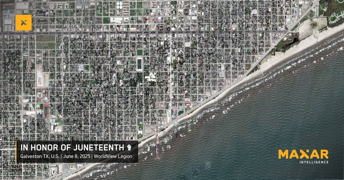
Today we recognize Juneteenth—the day in 1865 when freedom finally reached enslaved people in Galveston, Texas. This image from our WorldView Legion satellite shows where General Order No. 3 was issued, marking a turning point in the fight for justice and equality. At Maxar, we

Today we recognize Juneteenth—the day in 1865 when freedom finally reached enslaved people in Galveston, Texas. This image from our WorldView Legion satellite shows where General Order No. 3 was issued, marking a turning point in the fight for justice and equality.

At Maxar, we
Maxar Technologies (@maxar) 's Twitter Profile Photo

Space-based insights. Ground-level impact. 🌍 Maxar joins a new UNOOSA & Commonwealth partnership to strengthen global resilience—from flood modeling in Ghana to tracking food insecurity in Somalia. Blog by Amal Ezzeddine, VP MEA ⬇️ 🔗: blog.maxar.com/for-a-better-w…

Space-based insights. Ground-level impact. 🌍

Maxar joins a new <a href="/UNOOSA/">UNOOSA</a> &amp; Commonwealth partnership to strengthen global resilience—from flood modeling in Ghana to tracking food insecurity in Somalia.

Blog by Amal Ezzeddine, VP MEA ⬇️

🔗: blog.maxar.com/for-a-better-w…
Maxar Technologies (@maxar) 's Twitter Profile Photo

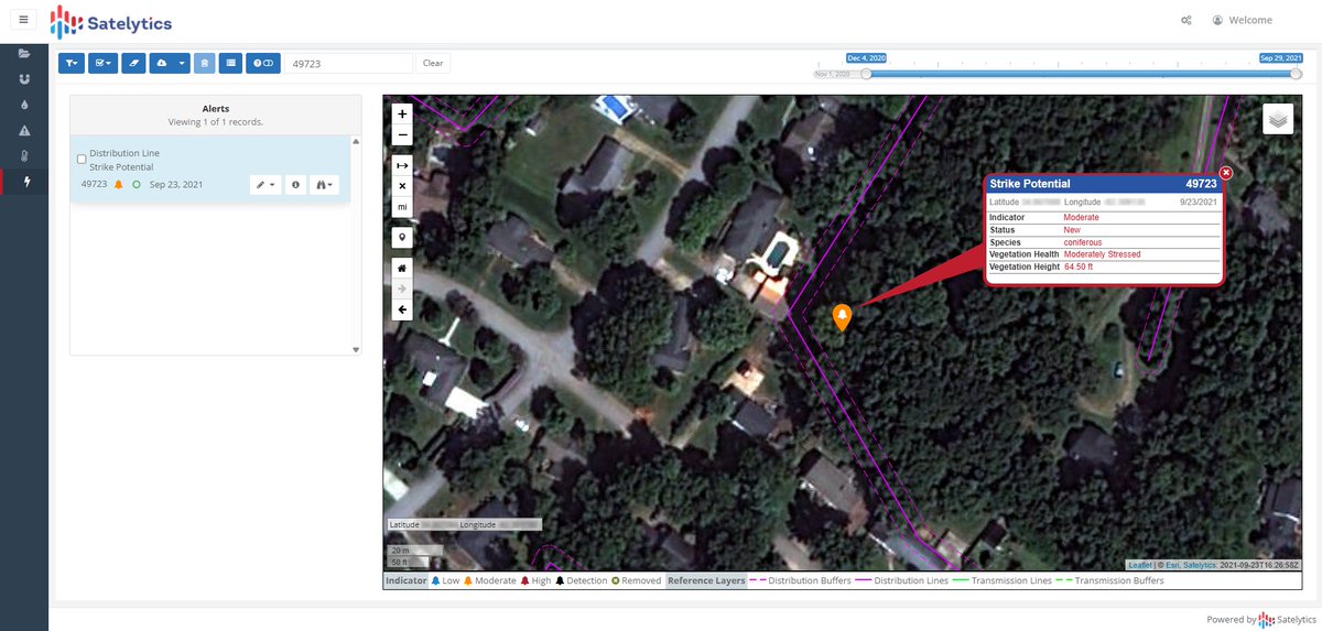
We’re expanding our offerings to the energy industry with our partner Satelytics: 🌳 A vegetation encroachment monitoring solution that leverages fresh satellite imagery to enable energy companies to prioritize sending ground crews to specific locations that need trimming (shown

We’re expanding our offerings to the energy industry with our partner Satelytics:

🌳 A vegetation encroachment monitoring solution that leverages fresh satellite imagery to enable energy companies to prioritize sending ground crews to specific locations that need trimming (shown