Mike Brookins πŸŠβ€β™‚οΈπŸš΄β€β™‚οΈπŸƒβ€β™‚οΈ (@mikebrookins) 's Twitter Profile
Mike Brookins πŸŠβ€β™‚οΈπŸš΄β€β™‚οΈπŸƒβ€β™‚οΈ

@mikebrookins

Morning & Noon Meteorologist on CBS5. Keeping you up to date on CNY weather. Triathlete, parrot head, beer connoisseur, husband & father in no particular order.

ID: 38026789

linkhttps://www.facebook.com/meteorologistmike.brookins/ calendar_today05-05-2009 21:34:33

14,14K Tweet

4,4K Followers

4,4K Following

Mike Brookins πŸŠβ€β™‚οΈπŸš΄β€β™‚οΈπŸƒβ€β™‚οΈ (@mikebrookins) 's Twitter Profile Photo

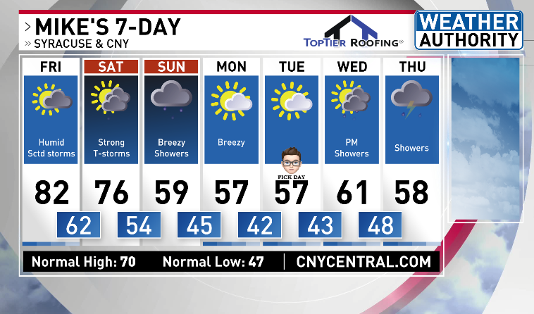
Going from late spring weather this afternoon in Syracuse, to a wintry feel with cold and snow next week. Check out my 4/3/2025 Thursday morning 7-day forecast video here youtu.be/cpTPrm6W8Fg

Mike Brookins πŸŠβ€β™‚οΈπŸš΄β€β™‚οΈπŸƒβ€β™‚οΈ (@mikebrookins) 's Twitter Profile Photo

The National Weather Service has issued a Flood Watch from 2 PM Today until 2 PM tomorrow for most of CNY. Soaked ground combined with heavy rain will lead to the threat of flash flooding. Heavy rain is possible in gusty thunderstorms from 2 PM today until midnight tonight.

The National Weather Service has issued a Flood Watch from 2 PM Today until 2 PM tomorrow for most of CNY. 
Soaked ground combined with heavy rain will lead to the threat of flash flooding. Heavy rain is possible in gusty thunderstorms from 2 PM today until midnight tonight.
Mike Brookins πŸŠβ€β™‚οΈπŸš΄β€β™‚οΈπŸƒβ€β™‚οΈ (@mikebrookins) 's Twitter Profile Photo

Flooding is a big story west/southwest of Syracuse. Additional rain this AM could bring new/minor flooding to parts of the CNY. Here's my Wednesday AM 7-day with when we finally dry! youtu.be/oPdL0apEFws

Mike Brookins πŸŠβ€β™‚οΈπŸš΄β€β™‚οΈπŸƒβ€β™‚οΈ (@mikebrookins) 's Twitter Profile Photo

As expected, non-severe thunderstorms are between 8-10 AM today from west to east. A bigger concern for gusty winds in thunderstorms later this afternoon. The greatest threat for flooding and damaging wind gusts comes on Saturday afternoon!

As expected, non-severe thunderstorms are between 8-10 AM today from west to east. 
A bigger concern for gusty winds in thunderstorms later this afternoon. 
The greatest threat for flooding and damaging wind gusts comes on Saturday afternoon!
Steph Shtoyko (@stephshtoyko) 's Twitter Profile Photo

We’re saying goodbye to our fabulous CBS5 This Morning producer, Barb β€” thank you for all the early mornings and awesome shows! And welcome (officially!) to Zack, now producing CBS5 This Morning! Catch us weekdays 5-7 a.m.β˜•οΈ

We’re saying goodbye to our fabulous CBS5 This Morning producer, Barb β€” thank you for all the early mornings and awesome shows! And welcome (officially!) to Zack, now producing CBS5 This Morning!

Catch us weekdays 5-7 a.m.β˜•οΈ
Mike Brookins πŸŠβ€β™‚οΈπŸš΄β€β™‚οΈπŸƒβ€β™‚οΈ (@mikebrookins) 's Twitter Profile Photo

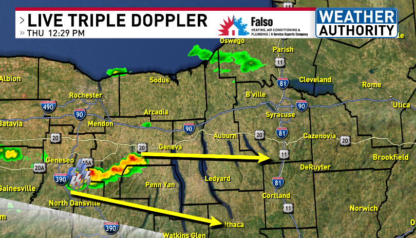
Growing thunderstorm threat in the southern Finger Lakes. A storm in southern Ontario county moves east & could strengthen to produce damaging winds 1-2 PM to the South/Southwest of Onondaga County. Radar> CNYcentral.com/weather

Growing thunderstorm threat in the southern Finger Lakes. A storm in southern Ontario county moves east & could strengthen to produce damaging winds 1-2 PM to the South/Southwest of Onondaga County. Radar> CNYcentral.com/weather
Meteorologist Peter Hall (@peteweatherbeat) 's Twitter Profile Photo

🚨Severe t-storm WARNING🚨 Until 1:45 PM yellow outlined areas. Storm movement in blue. DANGEROUS STORM circled IMPACTS: β€’DAMAGING wind of 60 MPHΒ  β€’LOCALIZED trees & wires may be damaged β€’LOCAL POWER OUTAGESΒ  β€’TORRENTIAL downpoursΒ  Radar/more: cnycentral.com

🚨Severe t-storm WARNING🚨

Until 1:45 PM yellow outlined areas. Storm movement in blue. DANGEROUS STORM circled 

IMPACTS:
β€’DAMAGING wind of 60 MPHΒ 
β€’LOCALIZED trees & wires may be damaged
β€’LOCAL POWER OUTAGESΒ 
β€’TORRENTIAL downpoursΒ 

Radar/more: cnycentral.com
Josh Kozlowski (@joshkozlowskiwx) 's Twitter Profile Photo

DAMAGE REPORTS are coming into CNY Central from NWS Binghamton office. 1) LOTS OF TREES DOWN IN TOMPKINS COUNTY caused by high wind gusts. 2) HAIL as large as GOLF BALLS and MANY TREES DOWN IN BROOME COUNTY. I'll have more damage reports to share on #CBS5 @ 5, 6, & #NBC3 at 7.
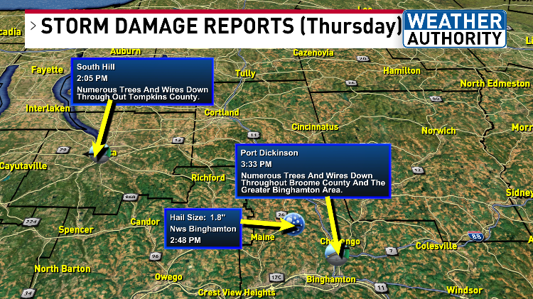
DAMAGE REPORTS are coming into <a href="/CNYCentral/">CNY Central</a> from <a href="/NWSBinghamton/">NWS Binghamton</a> office.

1) LOTS OF TREES DOWN IN TOMPKINS COUNTY caused by high wind gusts.

2) HAIL as large as GOLF BALLS and MANY TREES DOWN IN BROOME COUNTY.

I'll have more damage reports to share on #CBS5 @ 5, 6, &amp; #NBC3 at 7.