Eric Aldrich (@mizzoualdrich) 's Twitter Profile
Eric Aldrich

@mizzoualdrich

Meteorology Professor - University of Missouri; former broadcast meteorologist (KOMU-TV); Agricultural Fan; John Deere owner

ID: 1452399584

calendar_today23-05-2013 19:58:10

2,2K Tweet

1,1K Followers

451 Following

Mizzou Campus Weather Forecast (@mizzouwx) 's Twitter Profile Photo

It has been a very dry start to October and our first opportunity of rain is only a few days away!☔ Rain chances (30-40%) is expected late Thursday night into Friday morning.🌧️ More info check out: weather.missouri.edu/campus-weather… #mowx #Mizzou

It has been a very dry start to October and our first opportunity of rain is only a few days away!☔
Rain chances (30-40%) is expected late Thursday night into Friday morning.🌧️
More info check out: weather.missouri.edu/campus-weather…
#mowx #Mizzou
Mizzou Campus Weather Forecast (@mizzouwx) 's Twitter Profile Photo

Much-needed rain has fallen on Columbia! After 30 days without rain, this 0.15" is a welcome sight. It's been a long, dry spell, but we're hoping this is the beginning of some relief for the region. #MizzouWeather #ColumbiaMO #MoWx #MissouriMethod #MidMissouriWeather

Much-needed rain has fallen on Columbia! After 30 days without rain, this 0.15" is a welcome sight. It's been a long, dry spell, but we're hoping this is the beginning of some relief for the region. #MizzouWeather #ColumbiaMO #MoWx #MissouriMethod #MidMissouriWeather
Mizzou Campus Weather Forecast (@mizzouwx) 's Twitter Profile Photo

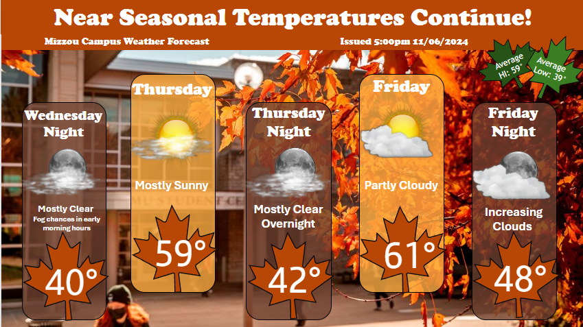
🍂🍂Seasonal Temperatures are back!🍂🍂 Dry and cool conditions will continue to persist through the end of the week! #mowx #weather #fall #Mizzou

🍂🍂Seasonal Temperatures are back!🍂🍂
Dry and cool conditions will continue to persist through the end of the week!
#mowx #weather #fall #Mizzou
Mizzou Campus Weather Forecast (@mizzouwx) 's Twitter Profile Photo

Moisture and cloud cover increases starting Friday and persists throughout the weekend providing a soggy gameday. For the complete forecast, check out weather.missouri.edu #mizzouwx #gotigers #mizzoumeteorology #dominatethesooners

Moisture and cloud cover increases starting Friday and persists throughout the weekend providing a soggy gameday. For the complete forecast, check out weather.missouri.edu 
#mizzouwx #gotigers #mizzoumeteorology #dominatethesooners
Mizzou Campus Weather Forecast (@mizzouwx) 's Twitter Profile Photo

Get ready for some rainfall this Wednesday, as a chance for showers is on its way and will reach us in the early afternoon. Remember your rainboots! 🌧️☔️🌈#MizzouWx #weather #Rain

Get ready for some rainfall this Wednesday, as a chance for showers is on its way and will reach us in the early afternoon. Remember your rainboots! 🌧️☔️🌈#MizzouWx #weather #Rain
NWS St. Louis (@nwsstlouis) 's Twitter Profile Photo

We expect most to see a dusting to 1 inch of snow Saturday. A narrow band of 2-3" of snow may form near the I-70 corridor, threatening minor travel impacts. Dry air may delay snow beginning, and uncertainty exists as to where the stronger band forms. Be careful if traveling!

We expect most to see a dusting to 1 inch of snow Saturday. A narrow band of 2-3" of snow may form near the I-70 corridor, threatening minor travel impacts. Dry air may delay snow beginning, and uncertainty exists as to where the stronger band forms. Be careful if traveling!
Matt Beckwith (@komumatt) 's Twitter Profile Photo

“This could be historic!” Yeah, the GFS tends to do stuff at 384 hours that would be historic because it’s fantasy land. Weather models in that range are like platform 9 & 3/4 fun in theory, but if you take a run at a brick wall, you’re going to bounce right off it.

NWS St. Louis (@nwsstlouis) 's Twitter Profile Photo

Impactful snow and ice is ongoing, and we need your help with reports! Please call, email, or reply here with exact location, your report, and a picture if you can! Share this far and wide so we can get more reports.

Impactful snow and ice is ongoing, and we need your help with reports! Please call, email, or reply here with exact location, your report, and a picture if you can!

Share this far and wide so we can get more reports.
NWS St. Louis (@nwsstlouis) 's Twitter Profile Photo

Data collection is essential to accurate forecasts. Offices like NWS Springfield release a minimum of 2 weather balloons a day (regardless of the weather) to get the latest atmospheric conditions. This information goes into weather models to set the starting conditions.

Bryan Norcross (@bryannorcrosstv) 's Twitter Profile Photo

MY OPINION: There was a plan to dismember and partially privatize NOAA and the National Weather Service in 1995. It was a bad idea then, and weakening those critical public-safety agencies is a worse idea now. More at bit.ly/4ioxHqu

Cassi Peters (@cassidenaep) 's Twitter Profile Photo

Our federal government cutting NOAA and NWS services, especially the Radar Operation Center in Norman will make life pretty unsafe here in Oklahoma during tornado season. Let me remind you what tornadoes can do. NWS saves lives!

Our federal government cutting NOAA and NWS services, especially the Radar Operation Center in Norman will make life pretty unsafe here in Oklahoma during tornado season. Let me remind you what tornadoes can do. NWS saves lives!
Josh Morgerman (@icyclone) 's Twitter Profile Photo

I'm still seeing comments saying, "I don't need the NWS! My weather app is better!" Folks don't understand that that cool app is just a parasite that feeds almost entirely off NWS data. The ignorance is stunning.

Andrew Markowitz (@amarkowitzwx) 's Twitter Profile Photo

Weather warnings: issued by NOAA Radar: maintained by NOAA Ground truth: observed by NOAA Hi-resolution models: produced by NOAA Without NOAA, it would be much harder to predict and detect storms in advance, making you more vulnerable to severe weather.

Weather warnings: issued by NOAA

Radar: maintained by NOAA

Ground truth: observed by NOAA

Hi-resolution models: produced by NOAA

Without NOAA, it would be much harder to predict and detect storms in advance, making you more vulnerable to severe weather.
Jessica Hafner (@jessicaabc17) 's Twitter Profile Photo

Have to give a big shout out to NWS St. Louis and NWS Springfield for their extreme diligence and constant updates during last night’s severe weather. We would not be able to be nearly as efficient on TV without their thorough messaging. A rough night for many! 🙏🏻 #midmowx

Tyler Roney (@tylerjroney) 's Twitter Profile Photo

Shoutout to the folks at the Storm Prediction Center and folks at the various National Weather Service offices impacted by severe weather on Friday. Your jobs are vital and you are valued.

Shoutout to the folks at the Storm Prediction Center and folks at the various National Weather Service offices impacted by severe weather on Friday. 

Your jobs are vital and you are valued.
Matt Beckwith (@komumatt) 's Twitter Profile Photo

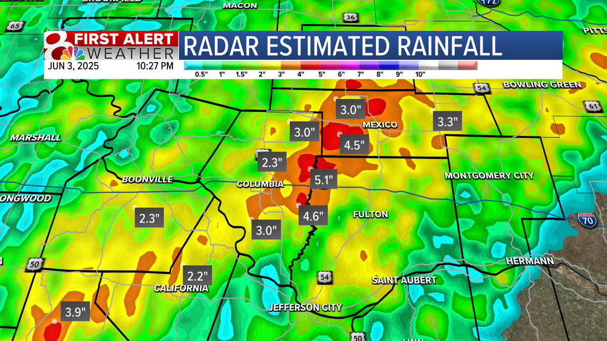
10:30PM Tuesday: Radar Estimated Rainfall Totals Missouri Mesonet Stations confirm 3+" of rain at each of their locations including Capen Park, MU Campus, Jefferson Farm, Bradford Research and Extension Center, & south farm. #MidMoWx #MoWx #MidMo

10:30PM Tuesday: Radar Estimated Rainfall Totals

Missouri Mesonet Stations confirm 3+" of rain at each of their locations including Capen Park, MU Campus, Jefferson Farm, Bradford Research and Extension Center, & south farm. #MidMoWx #MoWx #MidMo