MyRadar Weather (@myradarwx) 's Twitter Profile
MyRadar Weather

@myradarwx

Keeping you ahead of the storm since 2009. Download for FREE!

ID: 702278455

linkhttp://myradar.com/metdesk calendar_today18-07-2012 03:30:40

31,31K Tweet

125,125K Followers

880 Following

MyRadar Weather (@myradarwx) 's Twitter Profile Photo

🌊More than 100 people are dead following devastating flash flooding in Texas on July 4th weekend. It’s the deadliest non-tropical cyclone-related flash flood to hit the United States since 1976. MyRadar meteorologist Matthew Cappucci investigates what transpired.

MyRadar Weather (@myradarwx) 's Twitter Profile Photo

TROPICAL UPDATE for July 12: Keeping tabs on Florida, coastal Alabama and Louisiana... There are increasing signs of possible Gulf development next week. Heavy rainfall/flooding is possible over the Florida Peninsula and northern Gulf between Tuesday and Friday. A decaying

TROPICAL UPDATE for July 12: Keeping tabs on Florida, coastal Alabama and Louisiana...

There are increasing signs of possible Gulf development next week. Heavy rainfall/flooding is possible over the Florida Peninsula and northern Gulf between Tuesday and Friday.

A decaying
MyRadar Weather (@myradarwx) 's Twitter Profile Photo

SERIOUS OVERNIGHT FLOODING POSSIBLE IN TEXAS! Update from Matthew Cappucci: Forecast is quickly evolving with a few 10 inch rain totals likely! This could again impact areas between San Angelo and Austin/San Antonio in Texas Hill Country. A moisture-rich air mass is in place,
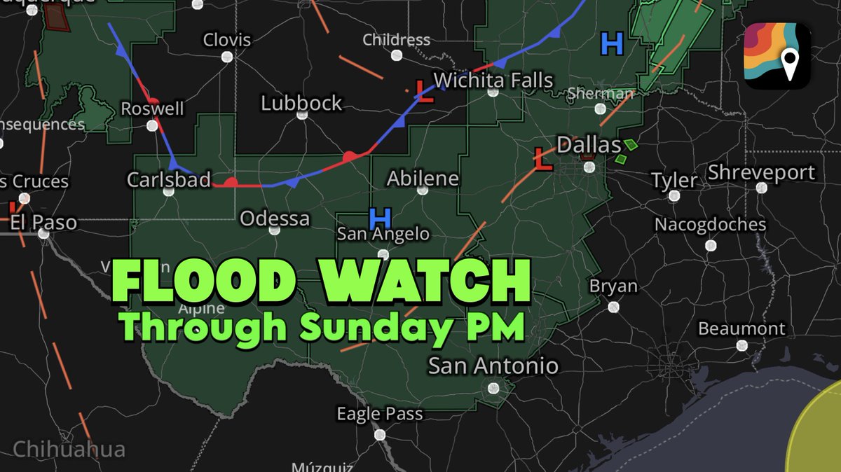
SERIOUS OVERNIGHT FLOODING POSSIBLE IN TEXAS! Update from <a href="/MatthewCappucci/">Matthew Cappucci</a>:

Forecast is quickly evolving with a few 10 inch rain totals likely! This could again impact areas between San Angelo and Austin/San Antonio in Texas Hill Country. 

A moisture-rich air mass is in place,
Matthew Cappucci (@matthewcappucci) 's Twitter Profile Photo

LIFE-THREATENING flash flooding developing overnight in TEXAS, including beleaguered portions of Hill Country! This will last into Sunday! A ā€œmesoscale convective vortex,ā€ or weak swirl of low pressure, has been left behind by since-dissipated thunderstorms. That’s helping

LIFE-THREATENING flash flooding developing overnight in TEXAS, including beleaguered portions of Hill Country! This will last into Sunday!

A ā€œmesoscale convective vortex,ā€ or weak swirl of low pressure, has been left behind by since-dissipated thunderstorms. That’s helping
MyRadar Weather (@myradarwx) 's Twitter Profile Photo

NEW: A flash flood warning has been issued for portions of the Guadeloupe River in Texas, including in Hunt, where Camp Mystic is located. Several inches of rain is falling, and downpours will continue throughout the morning. Renewed moderate flooding is possible.

Matthew Cappucci (@matthewcappucci) 's Twitter Profile Photo

BREAKING: The Lampasas River near Kempner (west of Killeen) in Texas has risen 31 FEET since early this morning! Major flood stage has been reached. There has been a 55,200% INCREASE in flow rate. It could fill an Olympic-sized swimming pool EVERY 1.3 SECONDS! MyRadar Weather

BREAKING: The Lampasas River near Kempner (west of Killeen) in Texas has risen 31 FEET since early this morning! Major flood stage has been reached. 

There has been a 55,200% INCREASE in flow rate. It could fill an Olympic-sized swimming pool EVERY 1.3 SECONDS! <a href="/MyRadarWX/">MyRadar Weather</a>
MyRadar Weather (@myradarwx) 's Twitter Profile Photo

BIGTIME rainfall totals in Texas, with 1.5 TRILLION gallons having fallen since last night in Texas Hill Country. That's enough to fill 2.3 BILLION Olympic-sized swimming pools. The heaviest totals fell in a narrow swath along the path of an "MCV," or mesoscale convective

BIGTIME rainfall totals in Texas, with 1.5 TRILLION gallons having fallen since last night in Texas Hill Country. 

That's enough to fill 2.3 BILLION Olympic-sized swimming pools. 

The heaviest totals fell in a narrow swath along the path of an "MCV," or mesoscale convective
Matthew Cappucci (@matthewcappucci) 's Twitter Profile Photo

ONE MONTH of rain in ONE HOUR! A weather station 15 miles west-southwest of San Saba, Texas recorded an incredible 3.71 inches of rain between 3:40 and 4:40 a.m. Sunday. The June average for San Saba is 3.62 inches and the July average is 1.85 inches. That means the weather

ONE MONTH of rain in ONE HOUR! 

A weather station 15 miles west-southwest of San Saba, Texas recorded an incredible 3.71 inches of rain between 3:40 and 4:40 a.m. Sunday.

The June average for San Saba is 3.62 inches and the July average is 1.85 inches. That means the weather
MyRadar Weather (@myradarwx) 's Twitter Profile Photo

*Tropical rainstorm/named storm possible in the Gulf by Wednesday or Thursday* SUMMARY: A gradually-developing low pressure system will cross Florida late Monday into Tuesday east to west, entering the Gulf and potentially acquiring tropical characteristics. A tropical storm may

*Tropical rainstorm/named storm possible in the Gulf by Wednesday or Thursday*

SUMMARY: A gradually-developing low pressure system will cross Florida late Monday into Tuesday east to west, entering the Gulf and potentially acquiring tropical characteristics. A tropical storm may
MyRadar Weather (@myradarwx) 's Twitter Profile Photo

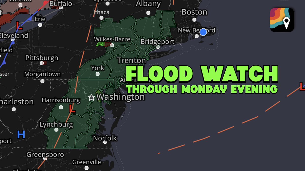
*Flood watch* in effect for much of interior Northeast, Mid-Atlantic... Strong thunderstorms with heavy rains are likely Monday afternoon along the Appalachians, pushing toward the East Coast in the afternoon. Rainfall rates in excess of 2 inches per hour are expected in the

*Flood watch* in effect for much of interior Northeast, Mid-Atlantic...

Strong thunderstorms with heavy rains are likely Monday afternoon along the Appalachians, pushing toward the East Coast in the afternoon. Rainfall rates in excess of 2 inches per hour are expected in the
MyRadar Weather (@myradarwx) 's Twitter Profile Photo

šŸŽ‰ Congrats to this week’s #MyRadarRainCheck winner — CollinsWx šŸŒŖļø! Just a few weeks left to enter for the grand prize: a brand new iPhone or Google Pixel! Details here šŸ‘‰ go.myradar.com/myradar-rainch…

MyRadar Weather (@myradarwx) 's Twitter Profile Photo

A low-pressure system near Florida is heading into the Gulf this week. šŸŒ€ Development chances: • 10% (48 hrs) • 30% (7 days) Regardless of formation, expect heavy rain and flash flooding across Florida & the north-central Gulf Coast.

A low-pressure system near Florida is heading into the Gulf this week.

šŸŒ€ Development chances:
• 10% (48 hrs)
• 30% (7 days)

Regardless of formation, expect heavy rain and flash flooding across Florida &amp; the north-central Gulf Coast.
Matthew Cappucci (@matthewcappucci) 's Twitter Profile Photo

There is something called an MCV, or mesoscale convective vortex, visible on satellite lifting northward from Coahuila. It’s a weak swirl in the atmosphere left by earlier storms The MCV will encourage air to rise, leading to more downpours in Texas this afternoon. MyRadar Weather

There is something called an MCV, or mesoscale convective vortex, visible on satellite lifting northward from Coahuila. It’s a weak swirl in the atmosphere left by earlier storms

The MCV will encourage air to rise, leading to more downpours in Texas this afternoon. <a href="/MyRadarWX/">MyRadar Weather</a>
MyRadar Weather (@myradarwx) 's Twitter Profile Photo

The NWS Weather Prediction Center has issued two areas of Moderate risk for excessive rainfall (red) today. They include portions of Texas and the Mid-Atlantic. Heavy rain will likely lead to Flash Flooding. Please heed all warnings and never drive through a flooded road!
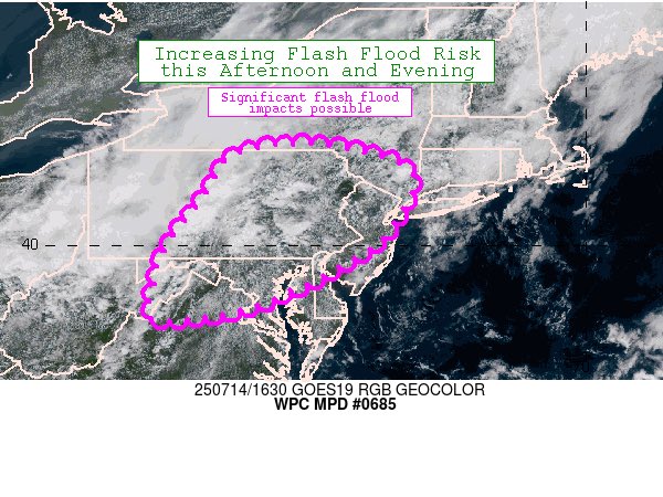
The <a href="/NWSWPC/">NWS Weather Prediction Center</a> has issued two areas of Moderate risk for excessive rainfall (red) today.

They include portions of Texas and the Mid-Atlantic.

Heavy rain will likely lead to Flash Flooding. 

Please heed all warnings and never drive through a flooded road!
MyRadar Weather (@myradarwx) 's Twitter Profile Photo

Invest 93L has officially formed just east of Florida. The National Hurricane Center has given it a 30% chance of tropical development over the next 7 days (20% over the next 48 hours), which is low. That said, once this passes over Florida and enters the Gulf, many possibilities are on

MyRadar Weather (@myradarwx) 's Twitter Profile Photo

Tropical update from Matthew Cappucci: Here we go, Gulf folks — first tropical threat of the season! Invest 93L has even designated. It was about 150 miles east of Cape Canaveral as of Monday afternoon, drifting west. The system does have a cohesive low-level circulation. Most
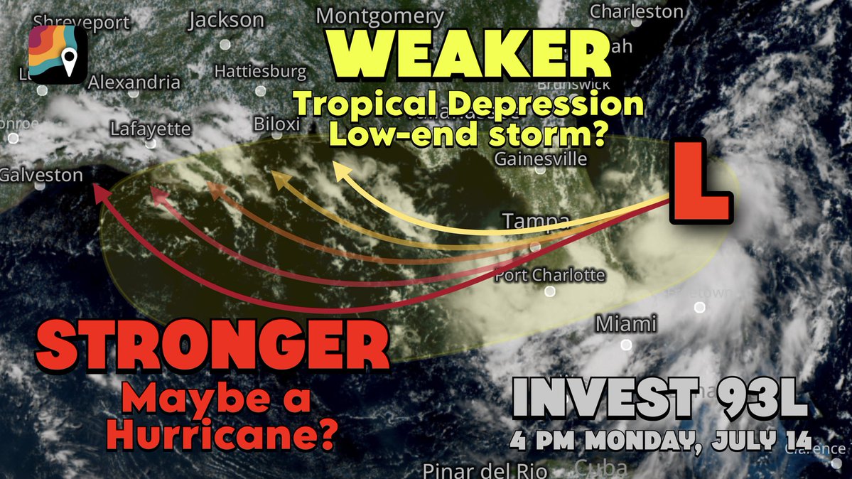
Tropical update from <a href="/MatthewCappucci/">Matthew Cappucci</a>:

Here we go, Gulf folks — first tropical threat of the season!

Invest 93L has even designated. It was about 150 miles east of Cape Canaveral as of Monday afternoon, drifting west.

The system does have a cohesive low-level circulation. Most
MyRadar Weather (@myradarwx) 's Twitter Profile Photo

We’re now up to a MEDIUM chance of development for Invest 93-L as it propagates west across Florida and eventually enters the Gulf. A tropical depression or storm could form on Wednesday or Thursday. Already, we’ve seen localized pockets of flash flooding on the Florida

We’re now up to a MEDIUM chance of development for Invest 93-L as it propagates west across Florida and eventually enters the Gulf. 

A tropical depression or storm could form on Wednesday or Thursday.

Already, we’ve seen localized pockets of flash flooding on the Florida