NASA Wallops (@nasawallops) 's Twitter Profile
NASA Wallops

@nasawallops

NASA's Wallops Flight Facility is NASA's only owned and operated launch range. Located on the Eastern Shore of Virginia.

Verification: nasa.gov/socialmedia

ID: 30258963

linkhttp://www.nasa.gov/wallops calendar_today10-04-2009 17:02:01

6,6K Tweet

327,327K Followers

168 Following

NASA Wallops (@nasawallops) 's Twitter Profile Photo

How are sounding rockets made? 🚀 At Wallops, we not only assemble and launch sounding rockets, but we also *custom make* about 150 parts for each one!

NASA Sun & Space (@nasasun) 's Twitter Profile Photo

Could you see auroras tonight? 👀 A solar eruption began its arrival at Earth this morning, sparking a geomagnetic storm that could mean dancing displays of northern (or southern) lights in your sky! Read NASA's tips for finding & photographing auroras: go.nasa.gov/3ZdsPxv

Could you see auroras tonight? 👀

A solar eruption began its arrival at Earth this morning, sparking a geomagnetic storm that could mean dancing displays of northern (or southern) lights in your sky! Read NASA's tips for finding & photographing auroras: go.nasa.gov/3ZdsPxv
NASA Wallops (@nasawallops) 's Twitter Profile Photo

NASA's P-3 aircraft will fly from Wallops between June 22 and June 26 to collect data as a part of the NASA Student Airborne Research Program for undergraduate interns. The aircraft will make a series of low-altitude atmospheric research flights near Philadelphia, Baltimore,

NASA Wallops (@nasawallops) 's Twitter Profile Photo

Launch success! 🚀 A sounding rocket launched this morning at 5:30 a.m. EDT from Wallops carrying student experiments for the RockOn! mission. Photo Credit: NASA/Teik Araya

Launch success! 🚀 

A sounding rocket launched this morning at 5:30 a.m. EDT from Wallops carrying student experiments for the RockOn! mission.

Photo Credit: NASA/Teik Araya
NASA Earth (@nasaearth) 's Twitter Profile Photo

A heat dome brought high heat and humidity to the eastern U.S. this month. This map, made with satellite observations and GEOS model data, shows air temperatures at 2 meters (6.5 feet) above the ground on June 24. earthobservatory.nasa.gov/images/154475/…

A heat dome brought high heat and humidity to the eastern U.S. this month.

This map, made with satellite observations and GEOS model data, shows air temperatures at 2 meters (6.5 feet) above the ground on June 24. earthobservatory.nasa.gov/images/154475/…
NASA History Office (@nasahistory) 's Twitter Profile Photo

When the beach is your research laboratory 🏖️ 80 years ago #OTD: The first rocket launch from Wallops Island, Virginia. This 1945 event marked the dawn of the site's important role in aerospace research and exploration. More NASA Wallops history go.nasa.gov/4n0puMB

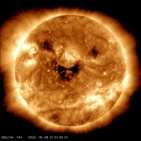
When the beach is your research laboratory 🏖️

80 years ago #OTD: The first rocket launch from Wallops Island, Virginia. This 1945 event marked the dawn of the site's important role in aerospace research and exploration. 

More <a href="/NASAWallops/">NASA Wallops</a> history go.nasa.gov/4n0puMB
NASA Sun & Space (@nasasun) 's Twitter Profile Photo

Two successful launches, and that’s a wrap! 🚀🚀 The two SEED mission rockets launched from Kwajalein Atoll in the Marshall Islands on June 20 and June 28, reaching peak altitudes of 95 miles (153 kilometers) and 97 miles (157 km), respectively. Preliminary data suggest that

Two successful launches, and that’s a wrap! 🚀🚀
 
The two SEED mission rockets launched from Kwajalein Atoll in the Marshall Islands on June 20 and June 28, reaching peak altitudes of 95 miles (153 kilometers) and 97 miles (157 km), respectively.
 
Preliminary data suggest that