National Center for Airborne Laser Mapping (@ncalm_uh) 's Twitter Profile
National Center for Airborne Laser Mapping

@ncalm_uh

Airborne geodetic imaging for the research community. #Lidar, science, archaeology. Geosensing Systems Engineering & Sciences grad program at UH.

ID: 1029409541849591808

linkhttp://ncalm.cive.uh.edu calendar_today14-08-2018 16:48:55

809 Tweet

828 Followers

70 Following

National Center for Airborne Laser Mapping (@ncalm_uh) 's Twitter Profile Photo

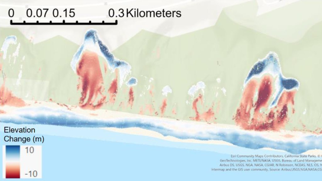
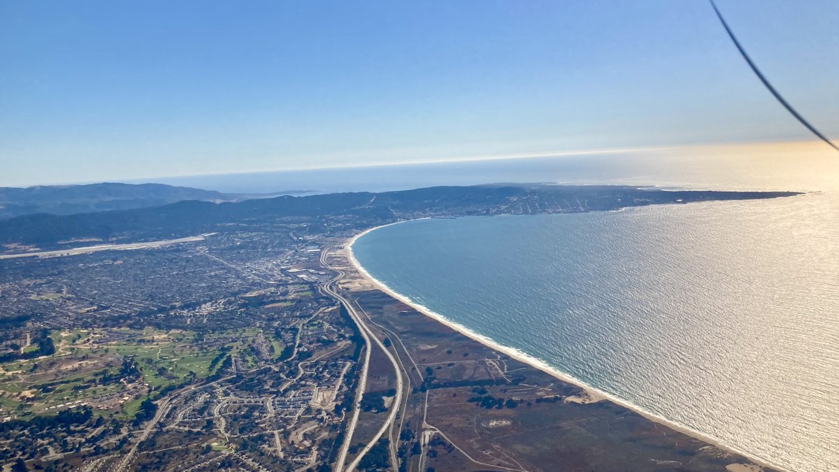
Spotlight: NCALM 2024 Seed Winner Shannon Sondeno will map dune erosion in Monterey Bay, CA, with #lidar & SfM. Their project tracks coastal changes post-sand mining closure to boost resilience. Nice work!

Spotlight: NCALM 2024 Seed Winner Shannon Sondeno will map dune erosion in Monterey Bay, CA, with #lidar & SfM. Their project tracks coastal changes post-sand mining closure to boost resilience. Nice work!
National Center for Airborne Laser Mapping (@ncalm_uh) 's Twitter Profile Photo

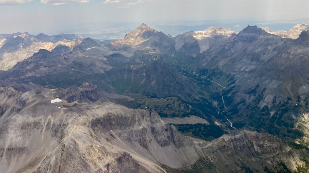
Spotlight: Recent Seed Winner Juliana Ruef will map rock glacier motion in CO's San Juan Mtns with #lidar. Their project tracks velocity & dynamics to reveal alpine evolution. Cool project!

Spotlight: Recent Seed Winner Juliana Ruef will map rock glacier motion in CO's San Juan Mtns with #lidar. Their project tracks velocity & dynamics to reveal alpine evolution. Cool project!
National Center for Airborne Laser Mapping (@ncalm_uh) 's Twitter Profile Photo

One of the coolest archaeological #lidar videos we've seen produced. See how laser scanning reveals hidden Maya cities under the jungle canopy! "Even after a century of study, there was still so much to be uncovered by airborne lidar." youtube.com/watch?v=--WuD_…

National Center for Airborne Laser Mapping (@ncalm_uh) 's Twitter Profile Photo

Spotlight: 2024 Seed Winner August Aalto will map carbon accumulation in Louisiana's Wax Lake Delta with #lidar. Their project tracks soil dynamics & subsidence to study delta growth. Nice work, August!

Spotlight: 2024 Seed Winner August Aalto will map carbon accumulation in Louisiana's Wax Lake Delta with #lidar. Their project tracks soil dynamics & subsidence to study delta growth. Nice work, August!
National Center for Airborne Laser Mapping (@ncalm_uh) 's Twitter Profile Photo

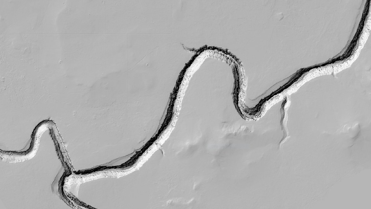
Spotlight: Joint Seed winners Michael Robinson & Brandon Fong will map slot canyon formation in AZ's East Clear Creek with high-res #lidar. Their project tests lithologic controls on erosion. Congratulations!

Spotlight: Joint Seed winners Michael Robinson & Brandon Fong will map slot canyon formation in AZ's East Clear Creek with high-res #lidar. Their project tests lithologic controls on erosion. Congratulations!
UH Cullen College of Engineering (@uhengineering) 's Twitter Profile Photo

🌍 Ever wondered how we map the Earth in 3D? #CullenCollege co-leads NCALM with UC Berkeley, providing high-res LiDAR data to NSF researchers. Led by Dr. Craig Glennie, the team maps land—and underwater terrain up to 10m deep—with precision. Learn more! ncalm.cive.uh.edu

🌍 Ever wondered how we map the Earth in 3D?

#CullenCollege co-leads NCALM with UC Berkeley, providing high-res LiDAR data to NSF researchers.

Led by Dr. Craig Glennie, the team maps land—and underwater terrain up to 10m deep—with precision.

Learn more! ncalm.cive.uh.edu
UH Cullen College of Engineering (@uhengineering) 's Twitter Profile Photo

PI Hyongki Lee & co-PIs Craig Glennie, Juan Carlos Fernandez Diaz & Surui Xie secured the first $500K of a potential $2.1M grant from NGA to grow the GSES grad program at National Center for Airborne Laser Mapping in ! Geodesy powers GPS, navigation & Earth monitoring. 🔗 egr.uh.edu/news/202507
PI Hyongki Lee &amp; co-PIs Craig Glennie, Juan Carlos Fernandez Diaz &amp; Surui Xie secured the first $500K of a potential $2.1M grant from <a href="/NGA_GEOINT/">NGA</a> to grow the GSES grad program at <a href="/NCALM_UH/">National Center for Airborne Laser Mapping</a> in ! 

Geodesy powers GPS, navigation &amp; Earth monitoring.
🔗 egr.uh.edu/news/202507
National Center for Airborne Laser Mapping (@ncalm_uh) 's Twitter Profile Photo

UNESCO Courier: #Lidar reveals Teotihuacan's secrets! NCALM's laser tech maps ancient cities & Teotihuacan-Tikal links. courier.unesco.org/en/articles/me…

UH Cullen College of Engineering (@uhengineering) 's Twitter Profile Photo

Join Provost Diane Chase on a thrilling journey into the cutting-edge world of LiDAR with Craig Glennie and the brilliant minds at NCALM (National Center for Airborne Laser Mapping). Watch the full video to see how UH researchers are pushing boundaries! youtube.com/watch?v=cCeYOM…

Join Provost Diane Chase on a thrilling journey into the cutting-edge world of LiDAR with Craig Glennie and the brilliant minds at NCALM (National Center for Airborne Laser Mapping). 

 Watch the full video to see how UH researchers are pushing boundaries! youtube.com/watch?v=cCeYOM…
UH Cullen College of Engineering (@uhengineering) 's Twitter Profile Photo

Inspired by Hurricane Harvey, UH’s Hyongki Lee is expanding his satellite-powered flood forecasting tool, FIER, with support from NASA, NOAA & global partners. His work is helping communities worldwide prepare for compound flooding events. Learn more: egr.uh.edu/news/202508/ce…

Inspired by Hurricane Harvey, UH’s Hyongki Lee is expanding his satellite-powered flood forecasting tool, FIER, with support from NASA, NOAA &amp; global partners.

His work is helping communities worldwide prepare for compound flooding events.

Learn more: egr.uh.edu/news/202508/ce…
National Center for Airborne Laser Mapping (@ncalm_uh) 's Twitter Profile Photo

Special Announcement: NCALM's 2025 Seed Program opens early, focusing on Alaska! Grad students & qualifying faculty can apply for #lidar data to study Arctic science. Apply by January 25, 2026: tinyurl.com/58ubey7c.

Special Announcement: NCALM's 2025 Seed Program opens early, focusing on Alaska! Grad students &amp; qualifying faculty can apply for #lidar data to study Arctic science. Apply by January 25, 2026: tinyurl.com/58ubey7c.
CLG (@drcraigglennie) 's Twitter Profile Photo

New article from National Center for Airborne Laser Mapping that simulates and tests an asynchronous lidar system, where the laser transmitter and detectors are carried on separate airborne platforms. sciencedirect.com/science/articl…

National Center for Airborne Laser Mapping (@ncalm_uh) 's Twitter Profile Photo

Nice article on our friends, Arlen & Diane Chase. 40 years digging in Belize, they were among the first to use airborne #lidar in Mesoamerica!

National Center for Airborne Laser Mapping (@ncalm_uh) 's Twitter Profile Photo

NCALM Seed Campaign: Airborne #lidar in Colorado's San Juan Mountains. To join our new 2025 Seed Proposal program, visit: tinyurl.com/58ubey7c.

NCALM Seed Campaign: Airborne #lidar in Colorado's San Juan Mountains. To join our new 2025 Seed Proposal program, visit: tinyurl.com/58ubey7c.
National Center for Airborne Laser Mapping (@ncalm_uh) 's Twitter Profile Photo

NCALM Seed Campaign: Mapping tree water stress in Dangermond Preserve with airborne #lidar! You can join next year's campaign with a Seed Proposal, open now: Details: tinyurl.com/58ubey7c Deadline: January 25, 2026

NCALM Seed Campaign: Mapping tree water stress in Dangermond Preserve with airborne #lidar! You can join next year's campaign with a Seed Proposal, open now:

Details: tinyurl.com/58ubey7c
Deadline: January 25, 2026
National Center for Airborne Laser Mapping (@ncalm_uh) 's Twitter Profile Photo

NCALM Seed Campaign: Final project, collecting #lidar on the coast for dune erosion study. Applications for next year's seed program are open now: tinyurl.com/58ubey7c.

NCALM Seed Campaign: Final project, collecting #lidar on the coast for dune erosion study. Applications for next year's seed program are open now: tinyurl.com/58ubey7c.
National Center for Airborne Laser Mapping (@ncalm_uh) 's Twitter Profile Photo

NCALM delivers! We're completing a #lidar dataset for Arizona slot canyons. Incredible topography. Want to map Alaska in 2026? Propose your Alaska Seed Project: tinyurl.com/58ubey7c, by Jan. 25, 2026.

NCALM delivers! We're completing a #lidar dataset for Arizona slot canyons. Incredible topography.

Want to map Alaska in 2026? Propose your Alaska Seed Project: tinyurl.com/58ubey7c, by Jan. 25, 2026.