NEODAAS Airborne (@nerc_arf_dan) 's Twitter Profile
NEODAAS Airborne

@nerc_arf_dan

Airborne Data Processing Node for @NCEOScience (nceo.ac.uk/facilities/) and support of ARSF archive at CEDA. Part of @NEODAAS.

ID: 4016705973

linkhttps://nerc-arf-dan.pml.ac.uk calendar_today22-10-2015 12:14:45

570 Tweet

336 Followers

164 Following

NEODAAS Airborne (@nerc_arf_dan) 's Twitter Profile Photo

"Classifying grass-dominated habitats from remotely sensed data:..." doi.org/10.1016/j.scit… New paper using Specim Fenix #hyperspectral data we processed. Data available from Centre for Environmental Data Analysis

"Classifying grass-dominated habitats from remotely sensed data:..."
doi.org/10.1016/j.scit…

New paper using <a href="/SpecimSpectral/">Specim</a> Fenix #hyperspectral data we processed. Data available from <a href="/cedanews/">Centre for Environmental Data Analysis</a>
NEODAAS Airborne (@nerc_arf_dan) 's Twitter Profile Photo

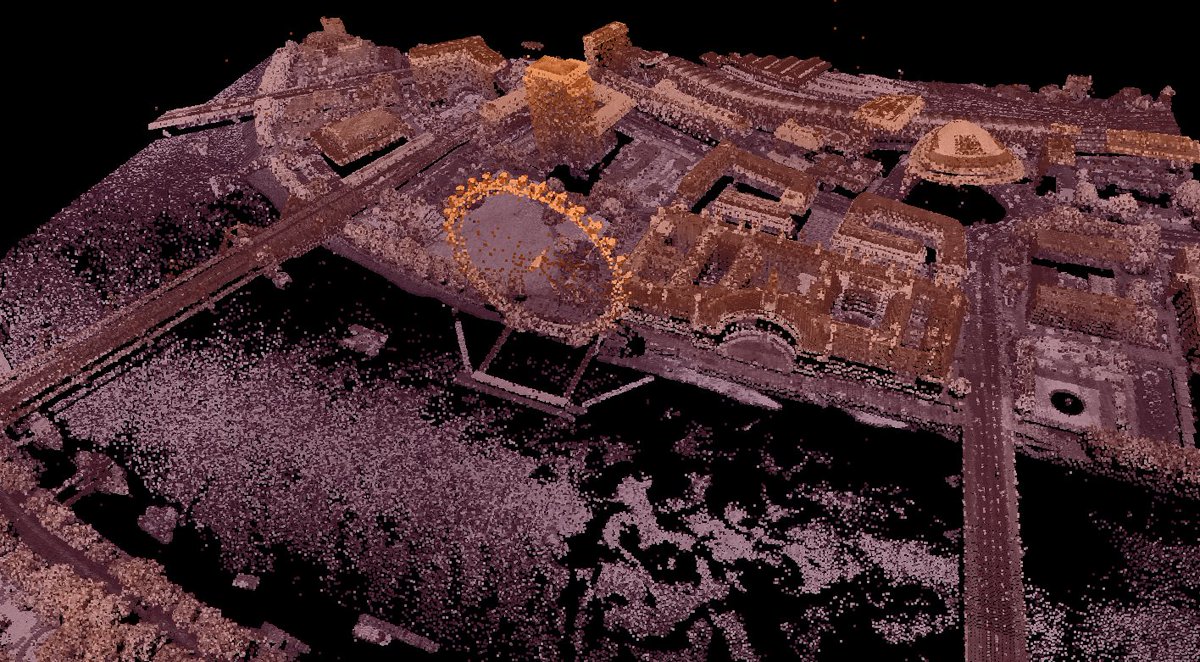
New paper using NERC-ARF #LiDAR data over London available from Centre for Environmental Data Analysis "Urban storage heat flux variability explored using satellite, meteorological and geodata" doi.org/10.1007/s00704…

NERC FSF (@nerc_fsf) 's Twitter Profile Photo

Don't forget our June 1st deadline for direct access loans support for fieldwork carried out Sept-March 2020/21. You can now apply to borrow UAV-mounted MAIA #Sentinel2 or #WV3 matched cameras along with all our other EO validation toys and technology. fsf.nerc.ac.uk/loans/

Don't forget our June 1st deadline for direct access loans support for fieldwork carried out Sept-March 2020/21. You can now apply to borrow UAV-mounted MAIA #Sentinel2 or #WV3 matched cameras along with all our other EO validation toys and technology. fsf.nerc.ac.uk/loans/
NERC FSF (@nerc_fsf) 's Twitter Profile Photo

Sunphotometers measure aerosol optical depth, to better remove atmospheric interference from satellite or airborne imagery. Find out how to use them in our new foray into video training #lookaroundyou youtube.com/watch?v=6Pg6hp…

Sunphotometers measure aerosol optical depth, to better remove atmospheric interference from satellite or airborne imagery.  Find out how to use them in our new foray into video training #lookaroundyou youtube.com/watch?v=6Pg6hp…
RSPSoc (@rspsoc) 's Twitter Profile Photo

MEASURE THE WORLD: RSPSoc2020 virtual conference. Thu, Sep 3, 2020 Registration is now open! register.gotowebinar.com/register/67539…

RSPSoc (@rspsoc) 's Twitter Profile Photo

Joint Editor, RSPSoc newsletter: we are inviting applications, from RSPSoc's membership, to join the editorial team of SENSED. For a small commitment of your time you could make a welcome contribution to the published output of the Society. rspsoc.org.uk/index.php/news…

NERC FSF (@nerc_fsf) 's Twitter Profile Photo

New to EO? Starting (or finishing) a PhD? FSF and @NEODAAS are running a virtual workshop this October. Learn all about turning those digital numbers into useful maps. Apply here: forms.office.com/Pages/Response… NERC NCEO Natural Environment Research Council

New to EO? Starting (or finishing) a PhD? FSF and @NEODAAS are running a virtual workshop this October. Learn all about turning those digital numbers into useful maps. Apply here: forms.office.com/Pages/Response…   <a href="/NCEOscience/">NERC NCEO</a> <a href="/NERCscience/">Natural Environment Research Council</a>
Plymouth Marine Lab (@plymouthmarine) 's Twitter Profile Photo

We're #recruiting a data scientist to develop environmental intelligence applications using #EarthObservation data, working within @NEODAAS, which provides UK researchers with EO data & services and has recently installed a new £1M 40-GPU cluster (MAGEO) Apply by 1st Nov ⬇️

NEODAAS Airborne (@nerc_arf_dan) 's Twitter Profile Photo

New paper out using Specim Eagle & Hawk #Hyperspectral data of the Iberian Pyrite Belt. Data is available Centre for Environmental Data Analysis. "Multispectral and hyperspectral remote sensing as a source of knowledge in the Portuguese sector of the Iberian Pyrite Belt" hdl.handle.net/10400.9/3337

Patrick Gray (@clifgray) 's Twitter Profile Photo

Upcoming NASA training on "Hyperspectral Data for Land and Coastal Systems" over the course of three Tuesdays (Jan 19th, Jan 26th, and Feb 2nd) each session is 1.5 hours: appliedsciences.nasa.gov/join-mission/t…

Hannah Griffiths (@hanmgriffiths) 's Twitter Profile Photo

Termites create hotspots of deadwood decomposition and carbon flux in rainforest canopy gaps! Check out our new paper in Global Change Biology to find out more :) Paul Eggleton Tom Swinfield Joel Woon Steven Allison Louise Ashton Kate Parr onlinelibrary.wiley.com/doi/10.1111/gc…

Plymouth Marine Lab (@plymouthmarine) 's Twitter Profile Photo

Today is the kick-off meeting for the International Ocean Colour Coordinating Group #IOCCG Task Force on Remote Sensing of #MarineLitter and Debris bit.ly/3aqT4r2 #MarinePlastics #PlasticPollution #Plastic

Today is the kick-off meeting for the International Ocean Colour Coordinating Group #IOCCG Task Force on Remote Sensing of #MarineLitter and Debris bit.ly/3aqT4r2 #MarinePlastics #PlasticPollution #Plastic
Ladies of Landsat (@ladiesoflandsat) 's Twitter Profile Photo

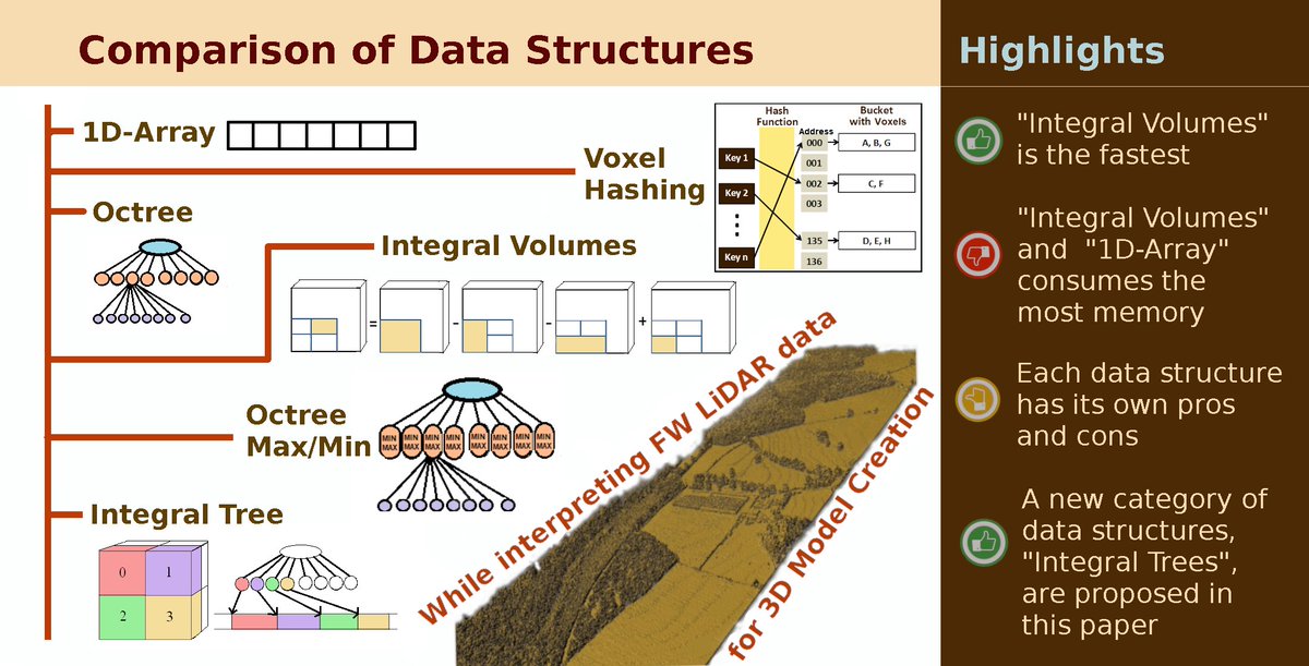
.Milto Miltiadou (She) et al. (2021) compare benefits and downsides of six voxelized full-waveform airborne #LiDAR data structures when creating 3D polygonal models from four #LiDAR flight lines collected by a Leica ALS550-II sensor in the UK. #LoLManuscriptMonday bit.ly/Miltiadou_2021
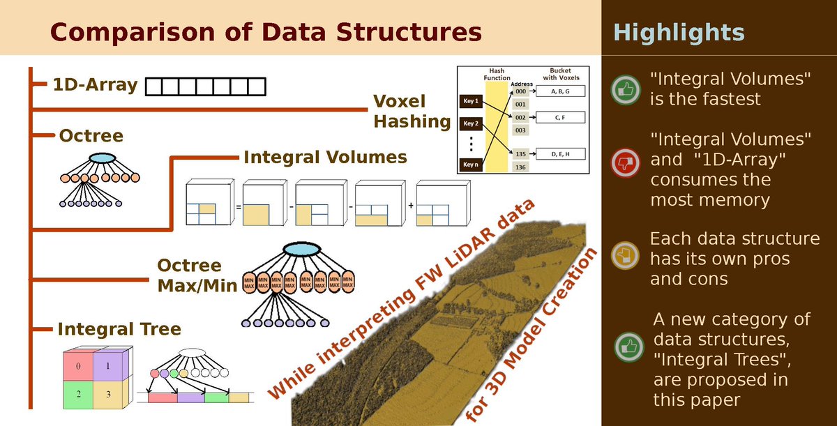
.<a href="/DrMiltiadou/">Milto Miltiadou (She)</a> et al. (2021) compare benefits and downsides of six voxelized full-waveform airborne #LiDAR data structures when creating 3D polygonal models from four #LiDAR flight lines collected by a Leica ALS550-II sensor in the UK. #LoLManuscriptMonday bit.ly/Miltiadou_2021
Kings-NCEO: Earth Obs & Wildfire Research Group (@kclwildfire_eo) 's Twitter Profile Photo

Back in Tuscany on two aircraft NASA & European Space Agency funded airborne campaign supporting new satellite missions. Both have thermal hyperspectral imagers, and today we unexpectedly imaged one from the other! King's Geography NERC NCEO @NEODAAS
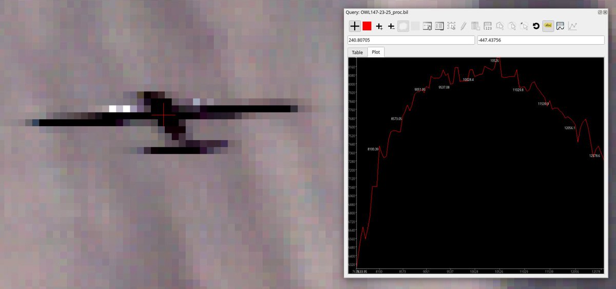
Back in Tuscany on two aircraft <a href="/NASA/">NASA</a> &amp; <a href="/esa/">European Space Agency</a> funded airborne campaign supporting new satellite missions. Both have thermal hyperspectral imagers, and today we unexpectedly imaged one from the other! <a href="/kclgeography/">King's Geography</a> <a href="/NCEOscience/">NERC NCEO</a> @NEODAAS