NOAA Digital Coast (@noaadigcoast) 's Twitter Profile
NOAA Digital Coast

@noaadigcoast

@NOAA Office for Coastal Management is a fed govt office working w/partners to provide data, tools & info. Verification: oceanservice.noaa.gov/socialmedia.ht…

ID: 218951054

linkhttp://www.coast.noaa.gov/ calendar_today23-11-2010 15:11:53

12,12K Tweet

19,19K Followers

3,3K Following

NOAA's Ocean Service (@noaaocean) 's Twitter Profile Photo

Many of us will be headed to the beach this weekend - do you know how to stay safe while you're swimming, surfing, sun bathing and whale watching? Visit our #NationalBeachSafetyWeek page and learn how to be prepared: oceanservice.noaa.gov/news/beach-saf… Photo credit: Zachery Valdez

Many of us will be headed to the beach this weekend - do you know how to stay safe while you're swimming, surfing, sun bathing and whale watching? Visit our #NationalBeachSafetyWeek page and learn how to be prepared: oceanservice.noaa.gov/news/beach-saf…
Photo credit: Zachery Valdez
NOAA Digital Coast (@noaadigcoast) 's Twitter Profile Photo

Why lidar? Planners can use it to identify areas prone to hazards, such as tsunamis. Download 2020 Richard Kaye topobathy lidar for the Washington coast through the Data Access Viewer. coast.noaa.gov/dataviewer/#/l…

Why lidar?

Planners can use it to identify areas prone to hazards, such as tsunamis.

Download 2020 <a href="/USACE/">Richard Kaye</a> topobathy lidar for the Washington coast through the Data Access Viewer. coast.noaa.gov/dataviewer/#/l…
NOAA Digital Coast (@noaadigcoast) 's Twitter Profile Photo

Estuary (es·tu·ar·y): where two distinct bodies of water meet. Can be saltwater or freshwater mixing. That’s right, this includes the #GreatLakes! Take the Lake Superior Reserve, where the St. Louis River meets #LakeSuperior. Learn more: coast.noaa.gov/nerrs/reserves…

Estuary (es·tu·ar·y): where two distinct bodies of water meet. Can be saltwater or freshwater mixing.

That’s right, this includes the #GreatLakes! Take the Lake Superior Reserve, where the St. Louis River meets #LakeSuperior. Learn more:
coast.noaa.gov/nerrs/reserves…
NOAA Digital Coast (@noaadigcoast) 's Twitter Profile Photo

From public access to permitting and beyond, the photographers submitting to our #CoastalManagement in Action contest this year really caught their good side! See all the winners and honorable mentions: coast.noaa.gov/about/photo-co…

From public access to permitting and beyond, the photographers submitting to our #CoastalManagement in Action contest this year really caught their good side! See all the winners and honorable mentions:
coast.noaa.gov/about/photo-co…
NOAA Digital Coast (@noaadigcoast) 's Twitter Profile Photo

Teachers! We’ve got education resources for your students and workshops out in the estuary for you. Coastal managers! We’ve got long-term data from across the reserve system that covers water quality, weather info, habitat data, and more. coast.noaa.gov/estuaries/

Teachers! We’ve got education resources for your students and workshops out in the estuary for you.

Coastal managers! We’ve got long-term data from across the reserve system that covers water quality, weather info, habitat data, and more.
coast.noaa.gov/estuaries/
NOAA Digital Coast (@noaadigcoast) 's Twitter Profile Photo

With this many fantastic photos, you knew we’d have some stellar honorable mentions! Let’s give some love to all of these amazing photos and their photographers for making this year’s #CoastalManagement in Action contest so great. coast.noaa.gov/about/photo-co…

With this many fantastic photos, you knew we’d have some stellar honorable mentions!

Let’s give some love to all of these amazing photos and their photographers for making this year’s #CoastalManagement in Action contest so great.
coast.noaa.gov/about/photo-co…
NOAA Digital Coast (@noaadigcoast) 's Twitter Profile Photo

Happy #NationalMaritimeDay! 🚢 It doesn’t get more maritime than the living resources within the ocean 🦞. Get the data that shows you nearshore, intertidal, and subtidal benthic habitat data from the Digital Coast. coast.noaa.gov/digitalcoast/d…

Happy #NationalMaritimeDay! 🚢

It doesn’t get more maritime than the living resources within the ocean 🦞. Get the data that shows you nearshore, intertidal, and subtidal benthic habitat data from the Digital Coast.
coast.noaa.gov/digitalcoast/d…
NOAA Digital Coast (@noaadigcoast) 's Twitter Profile Photo

From marine boundaries to ocean uses information, marine transportation to marine life data, the Marine Cadastre National Viewer lets you see and analyze datasets before downloading them for further use. noaa.maps.arcgis.com/apps/mapviewer… #NationalMaritimeDay

From marine boundaries to ocean uses information, marine transportation to marine life data, the Marine Cadastre National Viewer lets you see and analyze datasets before downloading them for further use.
noaa.maps.arcgis.com/apps/mapviewer… #NationalMaritimeDay
NOAA Digital Coast (@noaadigcoast) 's Twitter Profile Photo

Attn #MidAtlantic region! Higher than normal tides could happen on May 26 throughout the region. Some locations will have their highest tides of the year. Get more info: tidesandcurrents.noaa.gov/high-tide-floo…

Attn #MidAtlantic region!

Higher than normal tides could happen on May 26 throughout the region. Some locations will have their highest tides of the year. Get more info:
tidesandcurrents.noaa.gov/high-tide-floo…
NOAA Digital Coast (@noaadigcoast) 's Twitter Profile Photo

Our reserves celebrate #WorldTurtleDay all year long by helping sea turtles in need 🐢 Mission Aransas Reserve joined with other partners to help rehabilitate the record number of stranded loggerhead sea turtles in 2021 and that work continues today. coast.noaa.gov/states/stories…

Our reserves celebrate #WorldTurtleDay all year long by helping sea turtles in need 🐢

Mission Aransas Reserve joined with other partners to help rehabilitate the record number of stranded loggerhead sea turtles in 2021 and that work continues today.
coast.noaa.gov/states/stories…
NOAA Digital Coast (@noaadigcoast) 's Twitter Profile Photo

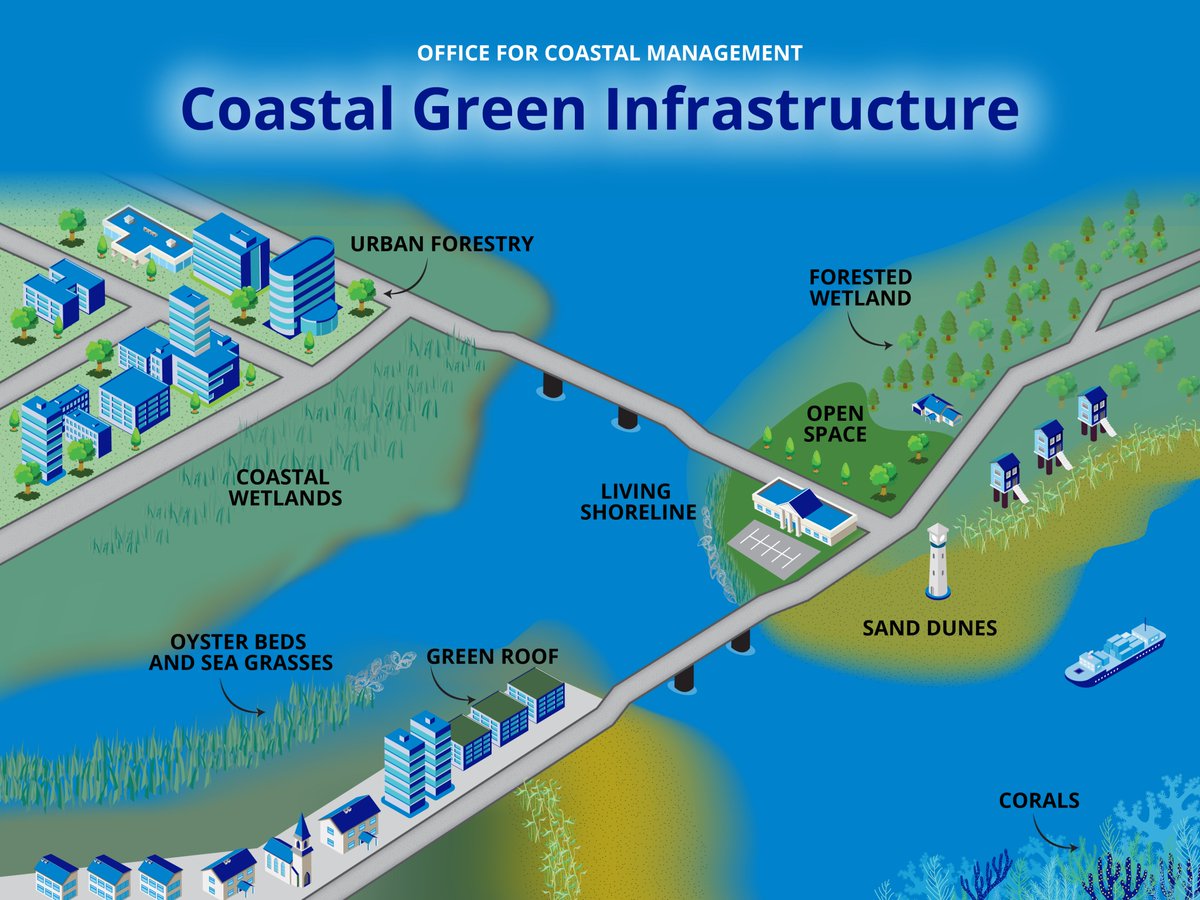
Our #GreenInfrastructure database just got a refresh! Search 300+ sources on the effectiveness & economic benefits of different green infrastructure types. Filter by scale, coastal hazard (ex. flooding) & geography to find the right info for your needs. coast.noaa.gov/digitalcoast/t…

Our #GreenInfrastructure database just got a refresh!

Search 300+ sources on the effectiveness &amp; economic benefits of different green infrastructure types. Filter by scale, coastal hazard (ex. flooding) &amp; geography to find the right info for your needs. coast.noaa.gov/digitalcoast/t…
NOAA Digital Coast (@noaadigcoast) 's Twitter Profile Photo

Get back into the mindset of a student this summer with a Teachers on the Estuary workshop! Experience professional development that gets you outside and on the water for immersive, place-based learning. Check the workshop calendar: coast.noaa.gov/estuaries/teac… #EnviroEd

Get back into the mindset of a student this summer with a Teachers on the Estuary workshop!

Experience professional development that gets you outside and on the water for immersive, place-based learning.

Check the workshop calendar:
coast.noaa.gov/estuaries/teac… #EnviroEd
NOAA Digital Coast (@noaadigcoast) 's Twitter Profile Photo

Did you know that NOAA sensors track oceanographic 🌊 and meteorological 🌦️ conditions in real time? Use the Tides & Currents map to access your local water levels, tide and current predictions, and more: tidesandcurrents.noaa.gov

Did you know that NOAA sensors track oceanographic 🌊 and meteorological 🌦️ conditions in real time?

Use the Tides &amp; Currents map to access your local water levels, tide and current predictions, and more:
tidesandcurrents.noaa.gov
NOAA Digital Coast (@noaadigcoast) 's Twitter Profile Photo

A project in Minnesota replaced a culvert that was blocking brook trout migration in a local creek. The new culvert is not only safer for fish to pass through, but also restored a creek trail for hikers, bikers, and recreational anglers to enjoy. coast.noaa.gov/states/stories… Minnesota DNR

A project in Minnesota replaced a culvert that was blocking brook trout migration in a local creek. The new culvert is not only safer for fish to pass through, but also restored a creek trail for hikers, bikers, and recreational anglers to enjoy. coast.noaa.gov/states/stories… <a href="/mndnr/">Minnesota DNR</a>
NOAA Digital Coast (@noaadigcoast) 's Twitter Profile Photo

How well do you understand how a hurricane could affect your community? Find resources to understand the risks, create storm surge maps, assess potential impacts and communicate them with others. Start here: coast.noaa.gov/digitalcoast/t…

How well do you understand how a hurricane could affect your community?

Find resources to understand the risks, create storm surge maps, assess potential impacts and communicate them with others. Start here:
coast.noaa.gov/digitalcoast/t…
NOAA Digital Coast (@noaadigcoast) 's Twitter Profile Photo

Why lidar? It helps us understand the shape of the Earth and see features in 3D, providing accurate measurements for mapping, civil engineering, construction, and more! Check out 2020 Maryland DNR lidar for Anne Arundel County: coast.noaa.gov/dataviewer/#/l…

Why lidar?

It helps us understand the shape of the Earth and see features in 3D, providing accurate measurements for mapping, civil engineering, construction, and more!

Check out 2020 <a href="/MarylandDNR/">Maryland DNR</a> lidar for Anne Arundel County:
coast.noaa.gov/dataviewer/#/l…
NOAA Digital Coast (@noaadigcoast) 's Twitter Profile Photo

Enjoy this Friday #MomentOfZen, brought to you from the sunny He'eia National Estuarine Research Reserve. 🧘🌈 Pictured here is the Reserve’s fish pond, a traditional Hawaiian aquaculture system. coast.noaa.gov/nerrs/reserves… 📷: Melissa Rietfors

Enjoy this Friday #MomentOfZen, brought to you from the sunny He'eia National Estuarine Research Reserve. 🧘🌈

Pictured here is the Reserve’s fish pond, a traditional Hawaiian aquaculture system. coast.noaa.gov/nerrs/reserves…

📷: Melissa Rietfors
NOAA Digital Coast (@noaadigcoast) 's Twitter Profile Photo

This summer, educators are getting their feet wet in estuaries across the country! They’ll be learning hands-on activities to take back to the classroom–like nature journaling, weather monitoring, and more. See the full workshop calendar: coast.noaa.gov/estuaries/teac… #TeacherTraining

This summer, educators are getting their feet wet in estuaries across the country! They’ll be learning hands-on activities to take back to the classroom–like nature journaling, weather monitoring, and more.

See the full workshop calendar: coast.noaa.gov/estuaries/teac… #TeacherTraining