NOAA Satellites (@noaasatellites) 's Twitter Profile
NOAA Satellites

@noaasatellites

The NOAA Satellite & Information Service (referred to as NESDIS) is a line office of @NOAA.

ID: 36711678

linkhttp://www.nesdis.noaa.gov/ calendar_today30-04-2009 16:58:50

25,25K Tweet

1,5M Followers

663 Following

NOAA Satellites (@noaasatellites) 's Twitter Profile Photo

As massive #wildfires burn across Canada, NOAA's satellites have been closely tracking the thick #smoke as it pours into the United States. Learn more about how NOAA's satellites monitor wildfires in this week's #EarthFromOrbit video: bit.ly/4jCEUn9

NWS Portland (@nwsportland) 's Twitter Profile Photo

Satellite imagery as of late Thursday morning shows low clouds gradually dissipating across northwest Oregon and southwest Washington. 🌤️ Expect a return of sunny skies and warm weather today! #ORwx #WAwx

NOAA Satellites (@noaasatellites) 's Twitter Profile Photo

Sometimes #hail on the ground looks just like snow—at least to our satellites! In this color-enhanced imagery from NOAA's #GOESWest 🛰️, snow on the ground typically appears reddish, while clouds appear white or pink. Yesterday, the reddish streak wasn’t snow—it was a swath of

NOAA Satellites (@noaasatellites) 's Twitter Profile Photo

As the sun rises this morning, NOAA's #GOESEast 🛰️ is tracking the clouds and #lightning moving across the northeastern U.S. There is a #SlightRisk of severe #thunderstorms developing over parts of southern New England today, with damaging winds possible. #GOES19 Latest:

NOAA Satellites (@noaasatellites) 's Twitter Profile Photo

That’s a lot of #lightning! ⚡️ This morning, NOAA’s #GOESEast 🛰️ is tracking more thunderstorms sweeping across the central and southern Plains. There is an #EnhancedRisk of severe storms for parts of the southern High Plains, while a #SlightRisk extends into the Tennessee and

NHC_TAFB (@nhc_tafb) 's Twitter Profile Photo

The National #Hurricane Center is monitoring two broad low #pressure systems south of Mexico in the East Pacific Ocean. The visible and enhance IR composite imagery reveals disorganized deep convection (orange color) mostly away from the low pressure centers.

NOAA Satellites (@noaasatellites) 's Twitter Profile Photo

Happy #FullDiskFriday! 🌎 In this view from NOAA's #GOESWest 🛰️ today you can see the sun rising across the beautiful Pacific Ocean as the Northern Hemisphere edges closer to the #SummerSolstice. You can also see two tropical disturbances west of Central America. #GOES18 What's

UW-Madison CIMSS (@uwcimss) 's Twitter Profile Photo

Farewell to NOAA Satellites #NOAA18 -- the polar orbiting satellite was decommissioned today. More details on the CIMSS Satellite Blog: cimss.ssec.wisc.edu/satellite-blog…

Farewell to <a href="/NOAASatellites/">NOAA Satellites</a> #NOAA18 -- the polar orbiting satellite was decommissioned today. More details on the CIMSS Satellite Blog: cimss.ssec.wisc.edu/satellite-blog…

NOAA Satellites (@noaasatellites) 's Twitter Profile Photo

This morning, NOAA's #GOESEast 🛰️ is tracking storm clouds and frequent #lightning flashes sweeping across the southern and eastern U.S. There is a #SlightRisk of severe #thunderstorms developing over the eastern part of the country today. #GOES19 Latest updates:

NHC_TAFB (@nhc_tafb) 's Twitter Profile Photo

We are currently tracking 3 tropical waves across the Atlantic. While tropical cyclone development is currently not expected through the next 7 days, tropical waves can still produce heavy rain and gusty, erratic winds. Visit hurricanes.gov/marine for more info!

NHC Eastern Pacific (@nhc_pacific) 's Twitter Profile Photo

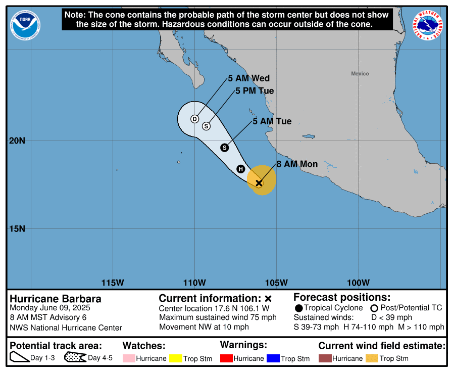
9 June #Barbara becomes the first hurricane of the 2025 east Pacific hurricane season. For the latest information visit hurricanes.gov

9 June #Barbara becomes the first hurricane of the 2025 east Pacific hurricane season. For the latest information visit hurricanes.gov
NOAA Satellites (@noaasatellites) 's Twitter Profile Photo

As a severe #thunderstorm outbreak unfolded over the southern Plains yesterday, NOAA’s #GOESEast 🛰️ tracked the storms in near real-time. There were numerous reports of golf ball-size hail falling across Texas, as well as wind gusts higher than 80 mph. #GOES19

NOAA (@noaa) 's Twitter Profile Photo

Just in: U.S. just saw it's 2nd-warmest #spring on record. Find summary and stats + map images from our report at: ncei.noaa.gov/news/national-… NOAA NCEI

Just in: U.S. just saw it's 2nd-warmest #spring on record.

Find summary and stats + map images from our report at:
ncei.noaa.gov/news/national-…

<a href="/NOAANCEI/">NOAA NCEI</a>
AerosolWatch (@aerosolwatch) 's Twitter Profile Photo

This morning 9 Jun, Aerosol Optical Depth (AOD) from ABI on NOAA Satellites GOES-East shows ongoing impacts of Canadian wildfires’ smoke: thick smoke over SE Canada & moderately thick smoke flowing into central CONUS around circulation of Low pressure centered over Lake Superior.

CIRA (@cira_csu) 's Twitter Profile Photo

Barbara has become the first hurricane of the 2025 East Pacific hurricane season. Nearby Tropical Storm Cosme is forecast later today to join Barbara in becoming a hurricane.

NOAA Satellites (@noaasatellites) 's Twitter Profile Photo

#Barbara has become the Eastern Pacific's first #hurricane of the 2025 season. NOAA's #GOESWest🛰️ is tracking #HurricaneBarbara (red circle) as it spins very close to #TropicalStorm #Cosme, off the western coast of Mexico. #GOES18 Get the latest: nhc.noaa.gov/?epac

NOAA Satellites (@noaasatellites) 's Twitter Profile Photo

Thunderstorms with frequent #lighting continue to move across the southern U.S. as NOAA's #GOESEast 🛰️ monitors the weather this morning. There is a #SlightRisk of severe #thunderstorms developing across southeastern New Mexico and western Texas today. #GOES19 Latest updates:

NOAA Satellites (@noaasatellites) 's Twitter Profile Photo

It's been a stormy week! 🌩️ This extended satellite imagery loop via NOAA's #GOESEast 🛰️ shows the outbreak of severe thunderstorms that raced across the southern Plains Sunday afternoon through early Monday. The storms brought damaging winds, large #hail, and several reports of

NOAA Satellites (@noaasatellites) 's Twitter Profile Photo

As the sun rises over the eastern Pacific today, NOAA's #GOESWest 🛰️ can see Tropical Storm #Cosme (left) and Tropical Storm #Barbara (right) churning off the coast of west-central Mexico. Both storms are beginning to weaken and not expected to impact land. #GOES18 Latest: