NWS Bay Area πŸŒ‰ (@nwsbayarea) 's Twitter Profile
NWS Bay Area πŸŒ‰

@nwsbayarea

Official Twitter account for the National Weather Service San Francisco Bay Area. Details: weather.gov/nws_x

ID: 596687292

linkhttps://www.weather.gov/NWSBayArea/ calendar_today01-06-2012 16:34:16

61,61K Tweet

192,192K Followers

638 Following

NWS Bay Area πŸŒ‰ (@nwsbayarea) 's Twitter Profile Photo

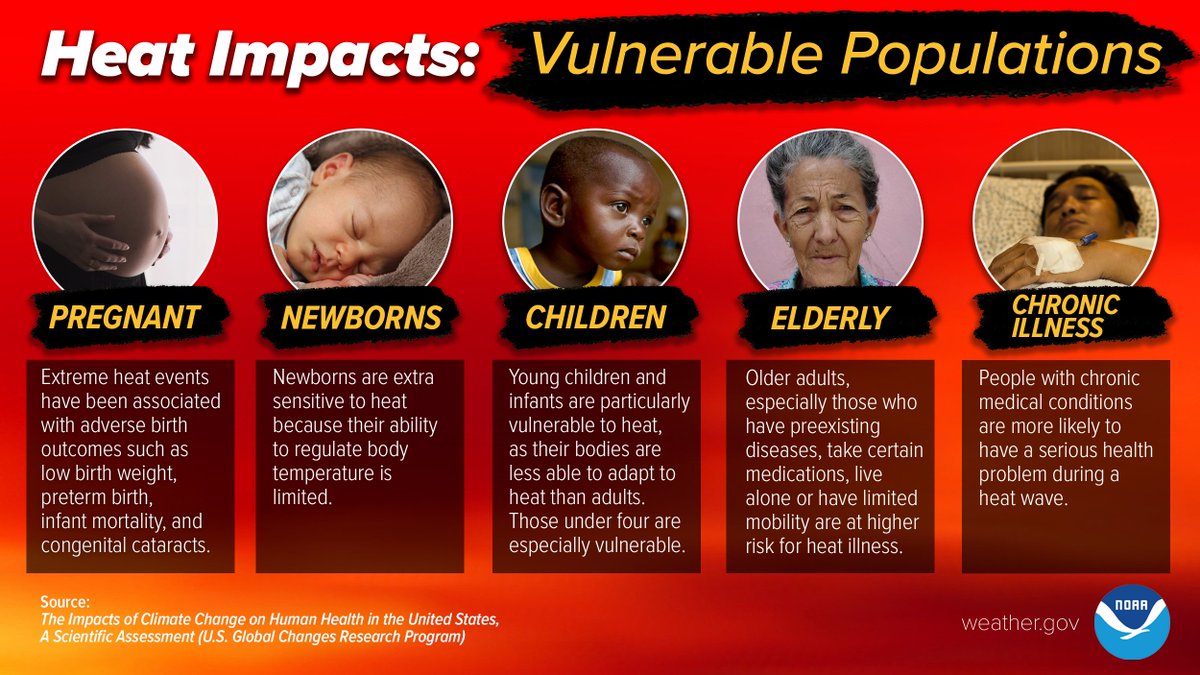
A warming trend for the remainder of the week will lead to areas of moderate HeatRisk in the interior of the Bay Area and Central Coast, corresponding to a risk for heat related illnesses in sensitive populations. Learn more about how to stay safe at weather.gov/safety/heat-du… #CAwx

A warming trend for the remainder of the week will lead to areas of moderate HeatRisk in the interior of the Bay Area and Central Coast, corresponding to a risk for heat related illnesses in sensitive populations. Learn more about how to stay safe at weather.gov/safety/heat-du… #CAwx
NWS Bay Area πŸŒ‰ (@nwsbayarea) 's Twitter Profile Photo

Proposed Termination of Various Environmental Modeling Center Web Sites and Data Products. Is it time to shutdown some NWS EMC Social Media webpages? See Public Information Statement for info and how to provide feedback. Marine users take note. This involves you. weather.gov/media/notifica…

NWS Bay Area πŸŒ‰ (@nwsbayarea) 's Twitter Profile Photo

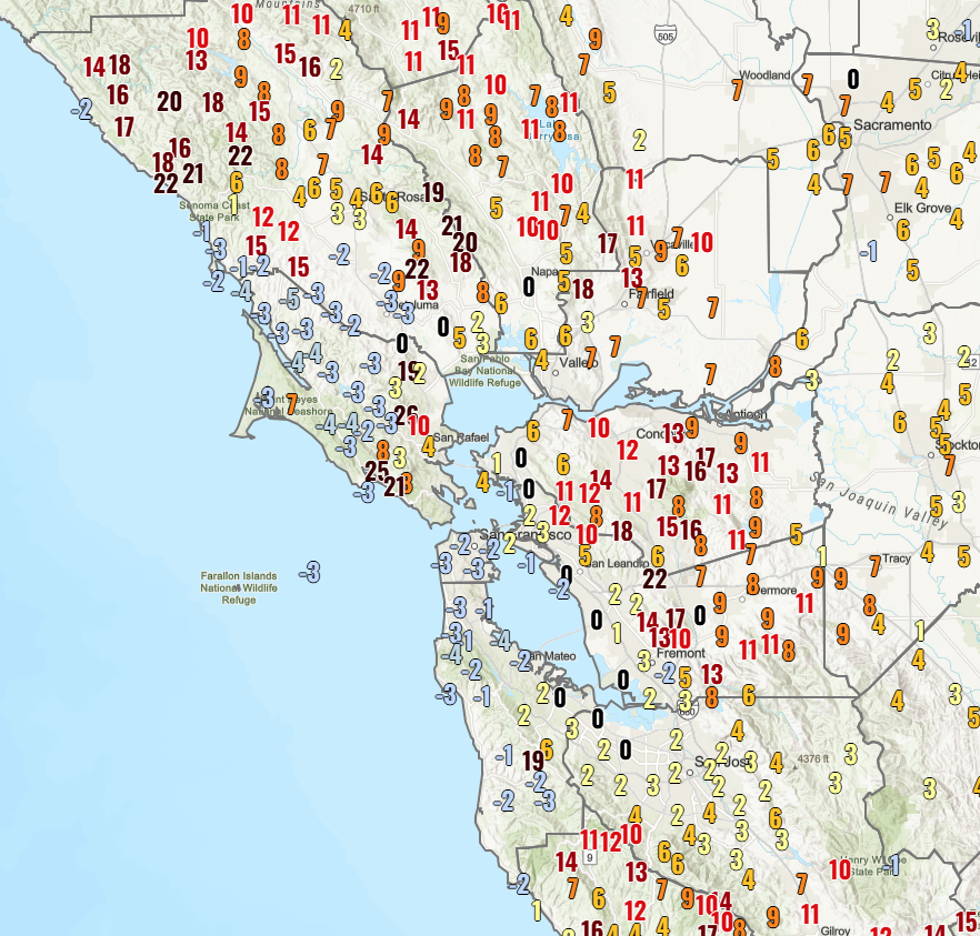
Feeling a bit warmer across the interior tonight? A look at the 24 hour temperature change shows temperatures are anywhere from 5 to 20 degrees warmer tonight than they were last night. This is thanks to a more compressed marine layer keeping stratus confined to the coast. #CAwx

Feeling a bit warmer across the interior tonight? A look at the 24 hour temperature change shows temperatures are anywhere from 5 to 20 degrees warmer tonight than they were last night.

This is thanks to a more compressed marine layer keeping stratus confined to the coast. #CAwx
NWS Bay Area πŸŒ‰ (@nwsbayarea) 's Twitter Profile Photo

With temperatures rising to the upper 80s to near 102 in the inland regions today, here's a very important reminder for everyone: Never, Never, NEVER leave children, disabled adults, the elderly, or pets in parked, unattended vehicles! weather.gov/safety/heat-ch… #WeatherReady #CAwx

With temperatures rising to the upper 80s to near 102 in the inland regions today, here's a very important reminder for everyone:

Never, Never, NEVER leave children, disabled adults, the elderly, or pets in parked, unattended vehicles! weather.gov/safety/heat-ch… #WeatherReady #CAwx
NWS Bay Area πŸŒ‰ (@nwsbayarea) 's Twitter Profile Photo

New NWS Climate Prediction Center El-Nino Southern Oscillation forecast shows neutral conditions are expected to last through the Summer with nearly equal chances of neutral or La Nina conditions this fall.
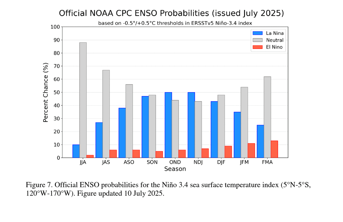
New <a href="/NWSCPC/">NWS Climate Prediction Center</a> El-Nino Southern Oscillation forecast shows neutral conditions are expected to last through the Summer with nearly equal chances of neutral or La Nina conditions this fall.
NWS Bay Area πŸŒ‰ (@nwsbayarea) 's Twitter Profile Photo

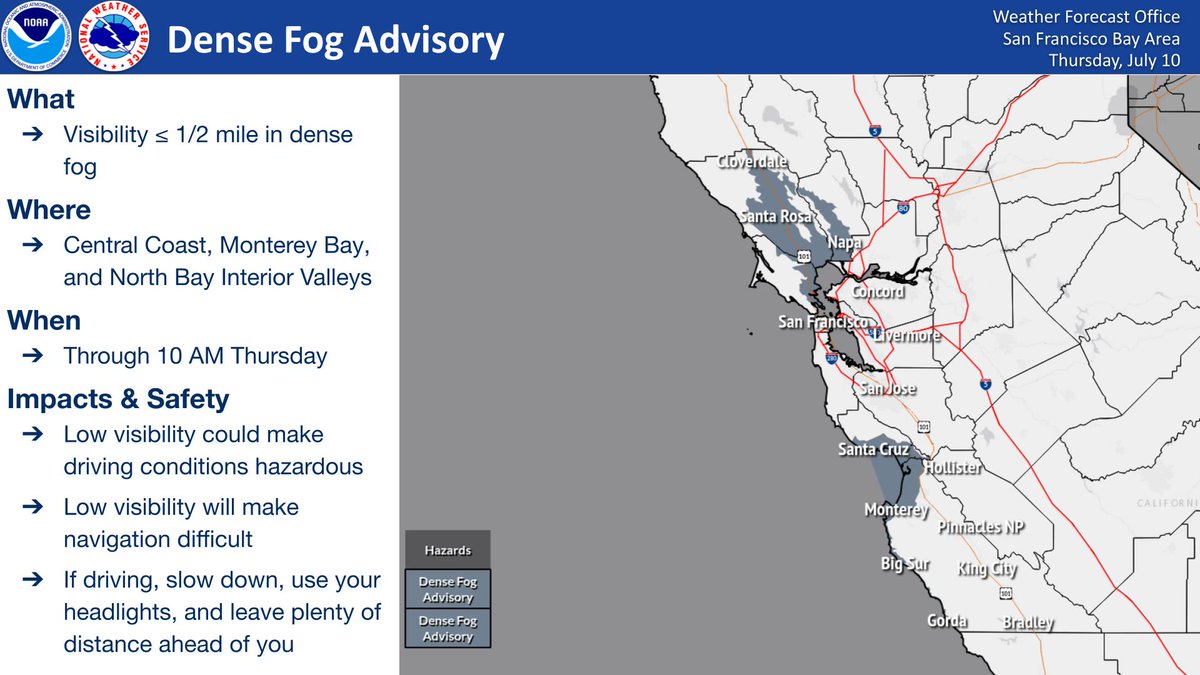
Dense Fog Advisory in effect through 10AM for the Central Coast, Monterey Bay, & North Bay Interior Valleys. Thus, drivers & mariners will be impacted. Please take the proper precautions as low visibility could make driving conditions hazardous & will make navigation difficult.

Dense Fog Advisory in effect through 10AM for the Central Coast, Monterey Bay, &amp; North Bay Interior Valleys. Thus, drivers &amp; mariners will be impacted. Please take the proper precautions as low visibility could make driving conditions hazardous &amp; will make navigation difficult.
NWS Bay Area πŸŒ‰ (@nwsbayarea) 's Twitter Profile Photo

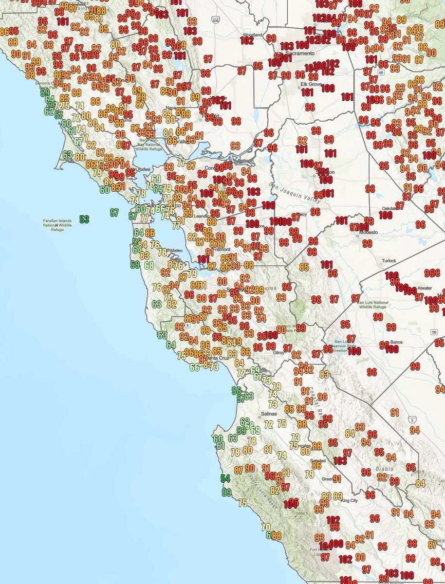
Take a look at today's observed high temperatures across the region. Most interior areas saw highs ranging from the mid 80s to upper 90s with a few spots reaching the low 100s. Another day of hot weather in the 80s to 90s is on top for tomorrow. #CAwx

Take a look at today's observed high temperatures  across the region. 

Most interior areas saw highs ranging from the mid 80s to upper 90s with a few spots reaching the low 100s.

Another day of hot weather in the 80s to 90s is on top for tomorrow. #CAwx
NWS Bay Area πŸŒ‰ (@nwsbayarea) 's Twitter Profile Photo

VisibleπŸ›°οΈsatellite showing wildfire smoke over NorCal drifting south into the Bay Area. Winds should shift around by late afternoon to help clear out some of the smoke.

NWS Bay Area πŸŒ‰ (@nwsbayarea) 's Twitter Profile Photo

Mt St Helena cam showing smoke from NorCal fires travelling from North to South. Note the wave feature. This is a trapped mountain lee wave, caught in a pocket of instability. Thanks to a media partner pointing this out to us.

NWS Bay Area πŸŒ‰ (@nwsbayarea) 's Twitter Profile Photo

A gradual cooling trend begins over the weekend and extends into next week, bringing inland temperatures near or slightly below the seasonal average. Just like Goldilocks: not too hot, not too cold. #CAwx

A gradual cooling trend begins over the weekend and extends into next week, bringing inland temperatures near or slightly below the seasonal average. Just like Goldilocks: not too hot, not too cold. #CAwx
NWS Bay Area πŸŒ‰ (@nwsbayarea) 's Twitter Profile Photo

Tonight's beautiful sunset comes from the Deer Park West camera in northern Napa County, operated by ALERTCalifornia. High-level smoke from fires in northern California is causing more scattering as the sun sets -- and thus, redder skies at night. #CAwx

NWS Bay Area πŸŒ‰ (@nwsbayarea) 's Twitter Profile Photo

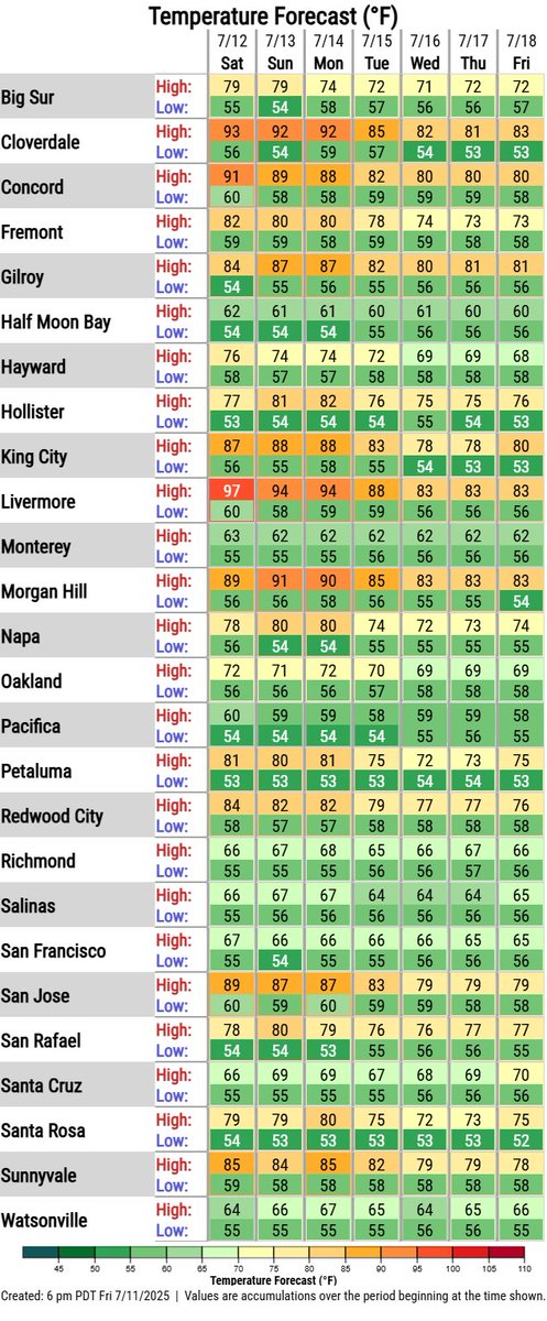
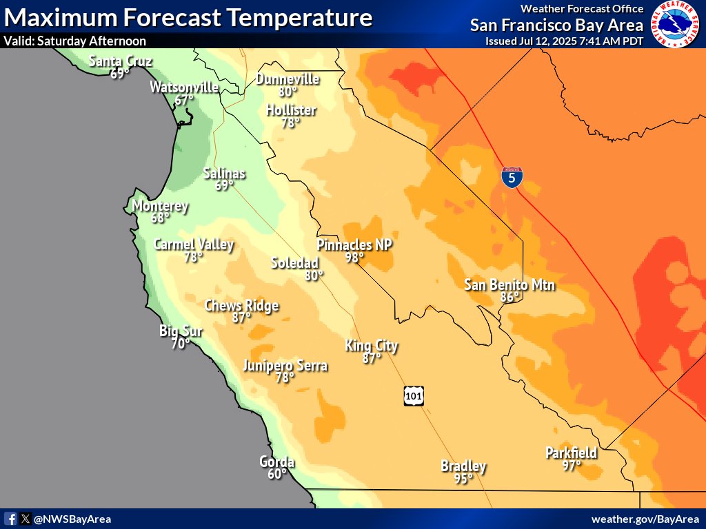
🌑️πŸ”₯Hot inland, cool coast! Forecast highs for Saturday (7/12) show a wide range across the Bay Area. Expect: β€’ 100–101Β°F: Far interior locations β€’ 80s–90s: Most inland valleys β€’ 60s–70s: Along the coast Stay hydrated & avoid strenuous activity during peak heat! #CAwx

🌑️πŸ”₯Hot inland, cool coast!
Forecast highs for Saturday (7/12) show a wide range across the Bay Area. Expect:
β€’ 100–101Β°F: Far interior locations
β€’ 80s–90s: Most inland valleys
β€’ 60s–70s: Along the coast
Stay hydrated &amp; avoid strenuous activity during peak heat! #CAwx
NWS Bay Area πŸŒ‰ (@nwsbayarea) 's Twitter Profile Photo

πŸ“‘Things you pick up weather radar Part 2: Two weeks ago we detected a 🚒along the Big Sur coast. Today, we're detecting vehiclesπŸš—πŸšš traveling on Highway 101 in the Salinas Valley. Bonus points for sea spray along the coast. #CAwx

NWS Bay Area πŸŒ‰ (@nwsbayarea) 's Twitter Profile Photo

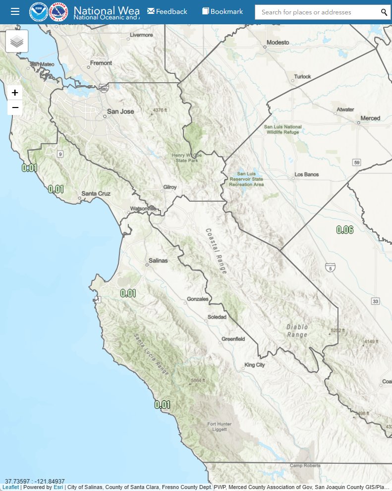
☁️🌦️ Coastal drizzle was observed across the region this morning, with rainfall totals generally below 0.04". Low clouds will linger near the coast through the day, while interior areas clear to mostly sunny skies. #CAwx #BayAreaWX #Drizzle

☁️🌦️ Coastal drizzle was observed across the region this morning, with rainfall totals generally below 0.04". Low clouds will linger near the coast through the day, while interior areas clear to mostly sunny skies. #CAwx #BayAreaWX #Drizzle
NWS Bay Area πŸŒ‰ (@nwsbayarea) 's Twitter Profile Photo

As the sun sets and the air and land temperature drop closer to the water temperature, we'll continue to see the low marine stratus clouds fill in farther inland this evening and overnight. Expect some patchy fog and drizzle for the Monday morning commute. #CAwx