Southeast River Forecast Center (SERFC) (@nwsserfc) 's Twitter Profile
Southeast River Forecast Center (SERFC)

@nwsserfc

Official Twitter account for the National Weather Service Southeast River Forecast Center Details: weather.gov/nws_x

ID: 599283881

linkhttps://www.weather.gov/serfc/ calendar_today04-06-2012 14:27:52

822 Tweet

3,3K Followers

130 Following

Southeast River Forecast Center (SERFC) (@nwsserfc) 's Twitter Profile Photo

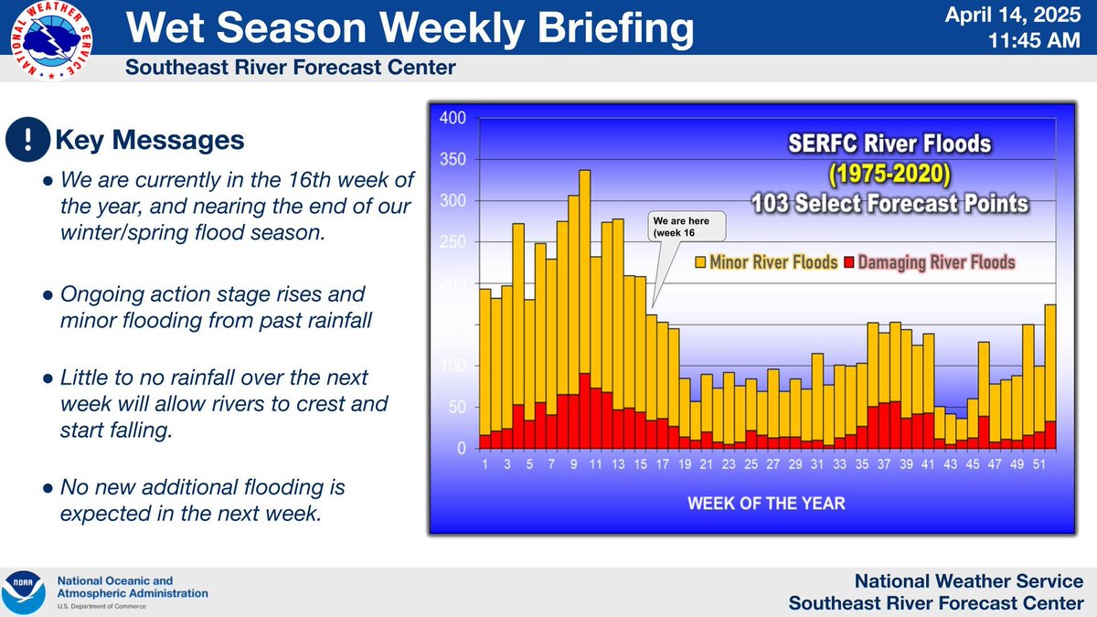
Quiet conditions over the next week will allow rivers to crest and start receding. For our full briefing visit weather.gov/media/serfc/al…

Quiet conditions over the next week will allow rivers to crest and start receding. For our full briefing visit weather.gov/media/serfc/al…
Southeast River Forecast Center (SERFC) (@nwsserfc) 's Twitter Profile Photo

The Southeast River Forecast Center's April 2025 Water Resources Outlook is now available at:youtu.be/jLw32c0uWMQ. This month we discuss the impacts of the La Niña on southeast rainfall and streamflow's as well as what to expect now as we are in ENSO neutral.

The Southeast River Forecast Center's April 2025 Water Resources Outlook is now available at:youtu.be/jLw32c0uWMQ. This month we discuss the impacts of the La Niña on southeast rainfall and streamflow's as well as what to expect now as we are in ENSO neutral.
NIDIS Drought.gov (@noaadrought) 's Twitter Profile Photo

Recording Available for April Southeast Webinar 24.9% of the Southeast is in drought. This webinar focused on conditions, outlooks, water resources, ag impacts + Coastal Flooding in the Southeast. youtube.com/watch?v=JPeC8F… NOAA SERCC Southeast River Forecast Center (SERFC) Pam Knox CIROH at The University of Alabama NOAA's Ocean Service

NWS San Juan (@nwssanjuan) 's Twitter Profile Photo

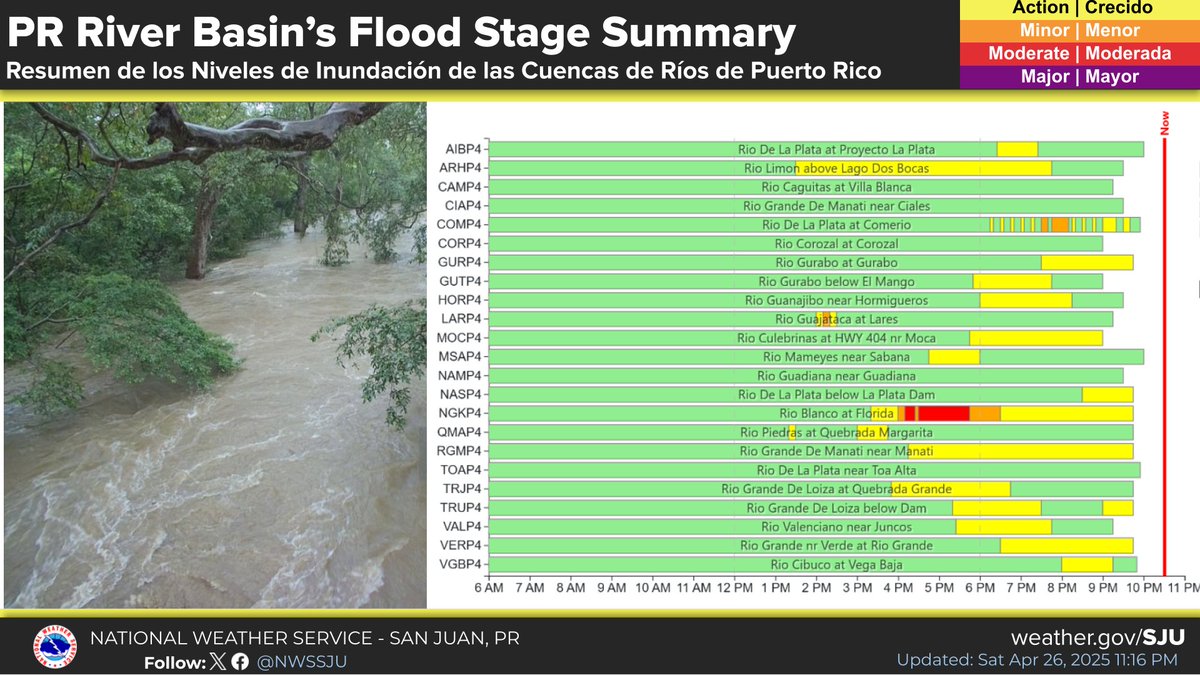
🌧️ Heavy Rains Impact Puerto Rico's Rivers Today 🌧️ Here’s a quick look at the Flood Stage Summary for river basins across Puerto Rico! - The chart shows river levels throughout the day (6 AM to 11 PM). #PRwx

🌧️ Heavy Rains Impact Puerto Rico's Rivers Today 🌧️

Here’s a quick look at the Flood Stage Summary for river basins across Puerto Rico! 

- The chart shows river levels throughout the day (6 AM to 11 PM).

#PRwx
NWS San Juan (@nwssanjuan) 's Twitter Profile Photo

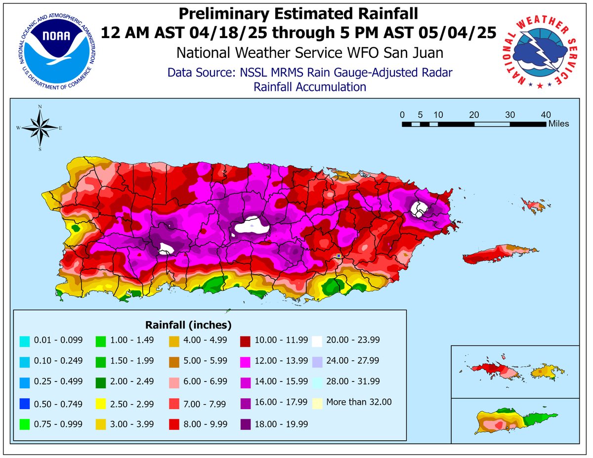
🌧️ Resumen de lluvia: 18 de abril – 4 de mayo de 2025 🌧️ Desde el fin de semana de Pascua, PR y USVI han estado bajo un patrón de tiempo húmedo e inestable prolongado, lo que ha provocado impactos generalizados #PRwx #USVIwx

🌧️ Resumen de lluvia: 18 de abril – 4 de mayo de 2025 🌧️

Desde el fin de semana de Pascua, PR  y USVI han estado bajo un patrón de tiempo húmedo e inestable prolongado, lo que ha provocado impactos generalizados

#PRwx #USVIwx
NWS San Juan (@nwssanjuan) 's Twitter Profile Photo

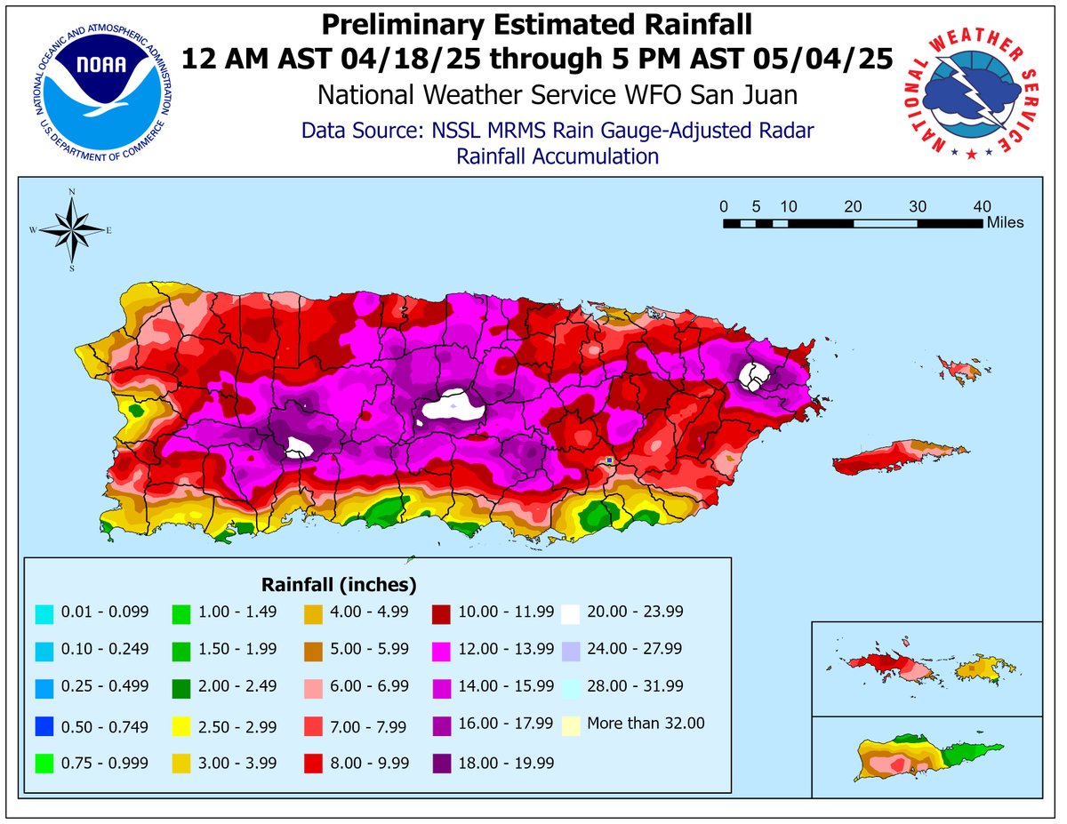
🌧️ Rainfall Summary: April 18 – May 4, 2025 🌧️ Since Easter weekend, Puerto Rico and the U.S. Virgin Islands have been under a prolonged wet and unstable weather pattern, bringing widespread impacts. #PRwx #USVIwx

🌧️ Rainfall Summary: April 18 – May 4, 2025 🌧️

Since Easter weekend, Puerto Rico and the U.S. Virgin Islands have been under a prolonged wet and unstable weather pattern, bringing widespread impacts. 

#PRwx #USVIwx
National Weather Service (@nws) 's Twitter Profile Photo

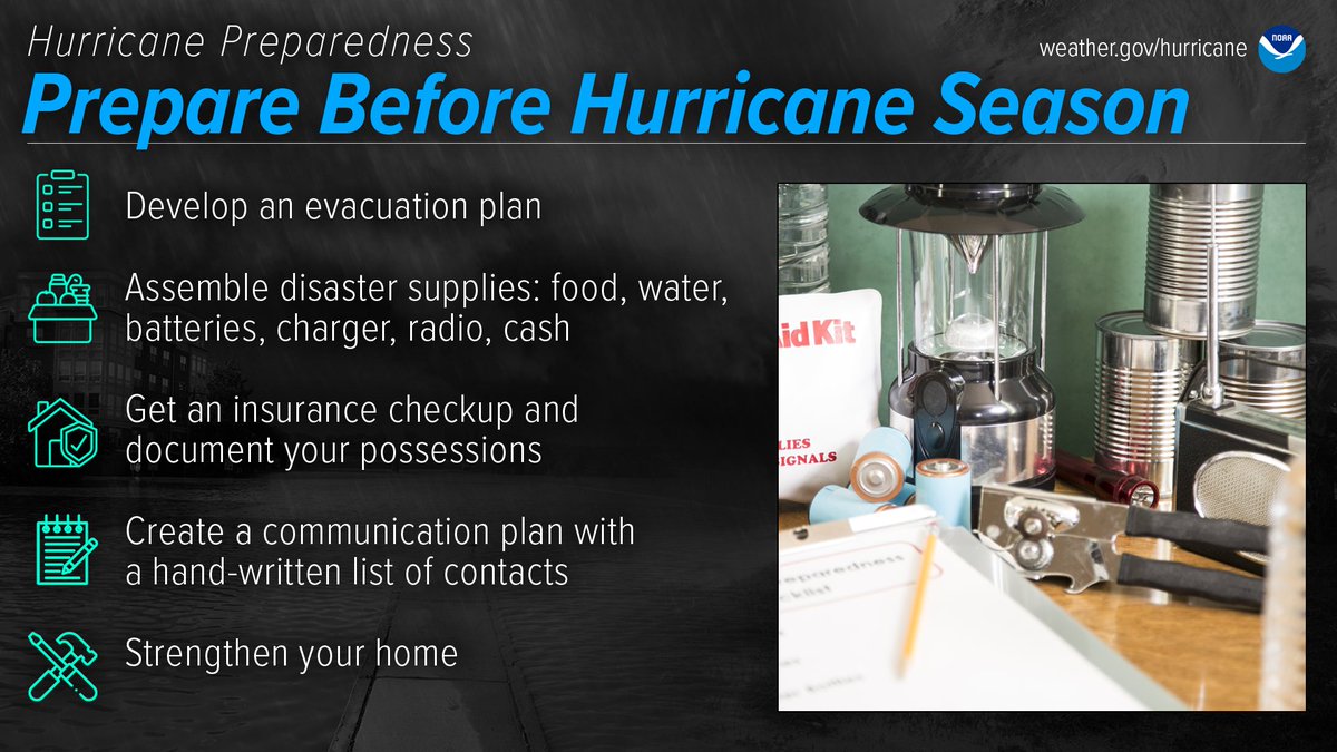
The best time to prepare for hurricanes is BEFORE hurricane season begins. Avoid having to rush through potentially life-saving preparations by waiting until it’s too late. #HurricanePrep #HurricaneStrong noaa.gov/prepare-before…

The best time to prepare for hurricanes is BEFORE hurricane season begins. Avoid having to rush through potentially life-saving preparations by waiting until it’s too late. #HurricanePrep #HurricaneStrong
noaa.gov/prepare-before…
National Weather Service (@nws) 's Twitter Profile Photo

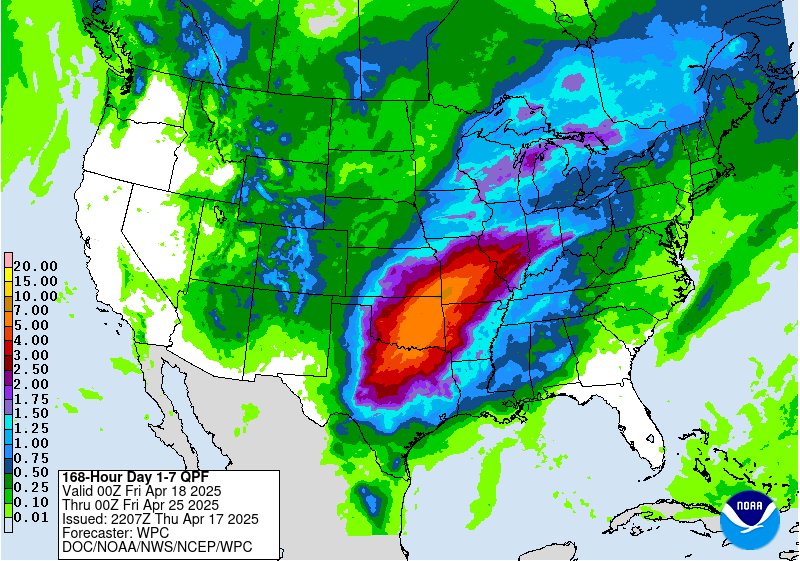
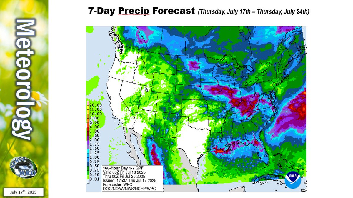
Here's the 7-day precipitation forecast across the lower 48 states (May 8 - 15). In summary: ⛈️Showers and thunderstorms across the southeast U.S. with rainfall totals of 3 to 6 inches in many locations and the potential for isolated river flooding Southeast River Forecast Center (SERFC) 🌧️Rain showers and

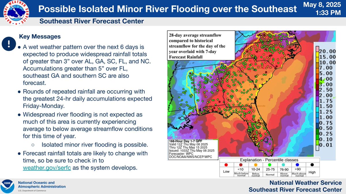
Here's the 7-day precipitation forecast across the lower 48 states (May 8 - 15). In summary:

⛈️Showers and thunderstorms across the southeast U.S. with rainfall totals of 3 to 6 inches in many locations and the potential for isolated river flooding <a href="/NWSSERFC/">Southeast River Forecast Center (SERFC)</a> 

🌧️Rain showers and
Southeast River Forecast Center (SERFC) (@nwsserfc) 's Twitter Profile Photo

The Southeast River Forecast Center's Water Resources Outlook for May 2025 is now available at youtu.be/LLmBfFP5L9E. Check it out to hear discussions about current streamflow trends in the #Southeast and what to expect heading into summer. 💧

Southeast River Forecast Center (SERFC) (@nwsserfc) 's Twitter Profile Photo

While rivers in Florida are expected to be elevated over the holiday weekend, it is too early to determine exact impacts at this time. Check out our ensembles for more information on potential river impacts in your area: weather.gov/source/erh/mme…

Southeast River Forecast Center (SERFC) (@nwsserfc) 's Twitter Profile Photo

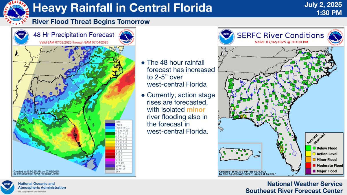
A heavy rain threat for west-central Florida, along with the potential for elevated rivers and minor river flooding, begins tonight and continues through the holiday weekend. Here is out our latest briefing: weather.gov/media/serfc/al…

A heavy rain threat for west-central Florida, along with the potential for elevated rivers and minor river flooding, begins tonight and continues through the holiday weekend. Here is out our latest briefing: weather.gov/media/serfc/al…
NWS Wilmington, NC (@nwswilmingtonnc) 's Twitter Profile Photo

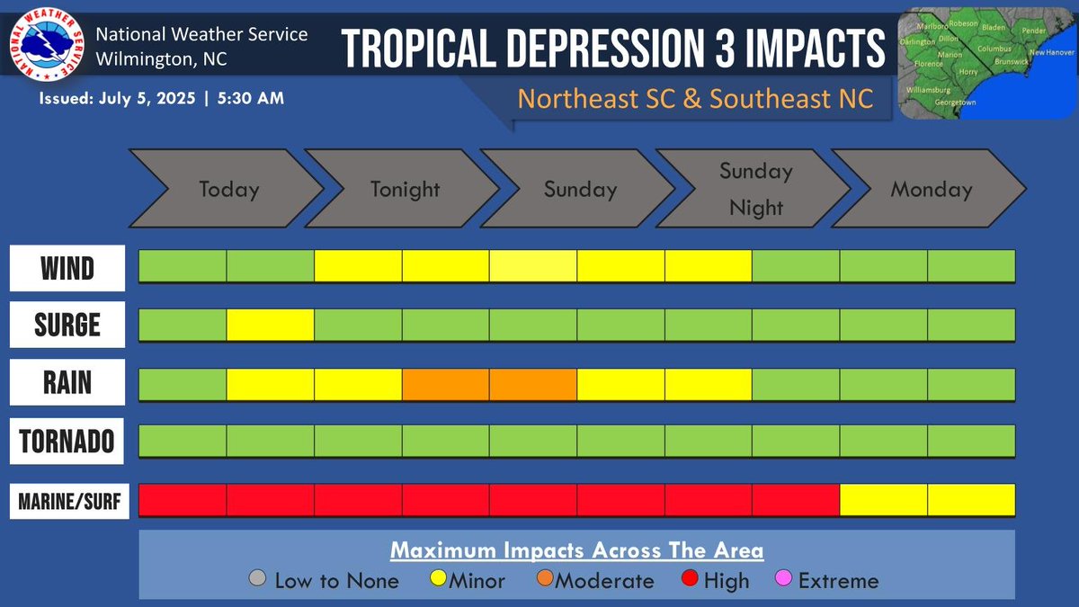
Tropical Depression Three will impact the area this weekend, with isolated flash flooding, a high rip current risk, and treacherous marine conditions being the main threats.

Tropical Depression Three will impact the area this weekend, with isolated flash flooding, a high rip current risk, and treacherous marine conditions being the main threats.
NWS Raleigh (@nwsraleigh) 's Twitter Profile Photo

🚨 955 pm: The Haw River at Bynum in Chatham County is now forecast to crest near 21.2 feet at around 8 am Monday morning. The river had surged up more than 4 feet during the past hour. This crest is just below the all time flood of record of 21.8 feet set during Hurricane Fran.

🚨 955 pm: The Haw River at Bynum in Chatham County is now forecast to crest near 21.2 feet at around 8 am Monday morning. The river had surged up more than 4 feet during the past hour. This crest is just below the all time flood of record of 21.8 feet set during Hurricane Fran.
Southeast River Forecast Center (SERFC) (@nwsserfc) 's Twitter Profile Photo

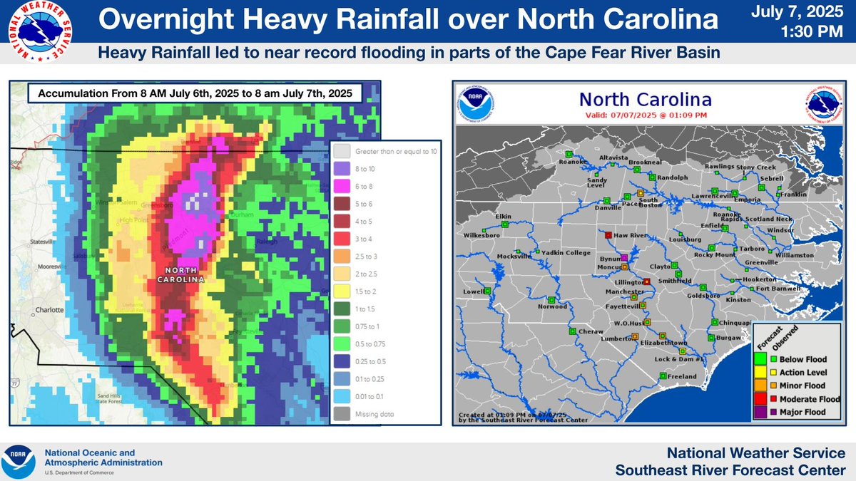
Rainfall of up to 10+ inches in North Carolina has led to near record flooding for portions of the Cape Fear River Basin, where parts of the Haw River neared levels seen almost 20 years ago. To keep up with the latest forecasts visit: weather.gov/serfc/

Rainfall of up to 10+ inches in North Carolina has led to near record flooding for portions of the Cape Fear River Basin, where parts of the Haw River neared levels seen almost 20 years ago. To keep up with the latest forecasts visit: weather.gov/serfc/
Southeast River Forecast Center (SERFC) (@nwsserfc) 's Twitter Profile Photo

Streamflow's across most of the Southeast are normal to above normal and normal rainfall is expected for the remainder of the month. Check out our July Water Resources Outlook at youtu.be/u0SUZC7MXus

Streamflow's across most of the Southeast are normal to above normal and normal rainfall is expected for the remainder of the month. Check out our July Water Resources Outlook at youtu.be/u0SUZC7MXus