NWS Baltimore-Washington (@nws_baltwash) 's Twitter Profile
NWS Baltimore-Washington

@nws_baltwash

Official X Account for National Weather Service Baltimore/Washington. For NWS Posting Policy, click here: weather.gov/nws_x

ID: 860334187

linkhttp://www.weather.gov/washington calendar_today03-10-2012 20:56:08

27,27K Tweet

77,77K Followers

283 Following

NWS Baltimore-Washington (@nws_baltwash) 's Twitter Profile Photo

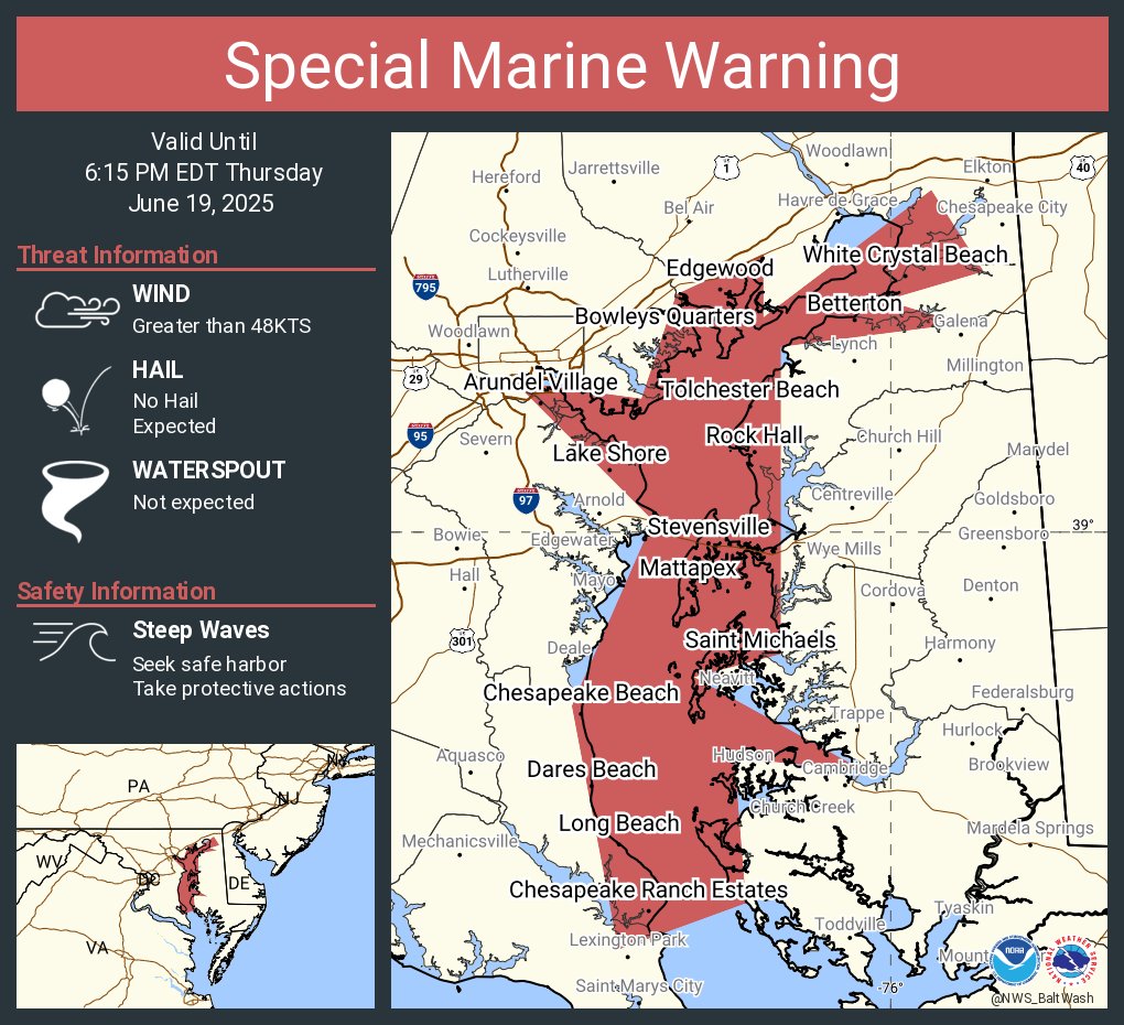
Special Marine Warning including the Chesapeake Bay from North Beach to Drum Point MD, Chesapeake Bay from Pooles Island to Sandy Point MD, Chesapeake Bay north of Pooles Island MD, Chesapeake Bay from Sandy Point to North Beach MD and Eastern Bay until 6:15 PM EDT

Special Marine Warning including the Chesapeake Bay from North Beach to Drum Point MD, Chesapeake Bay from Pooles Island to Sandy Point MD, Chesapeake Bay north of Pooles Island MD, Chesapeake Bay from Sandy Point to North Beach MD and Eastern Bay until 6:15 PM EDT
NWS Baltimore-Washington (@nws_baltwash) 's Twitter Profile Photo

Severe Thunderstorm Warning continues for Washington DC, Arlington VA and Alexandria VA until 4:45 PM EDT. This storm will contain wind gusts to 70 MPH!

Severe Thunderstorm Warning continues for Washington DC, Arlington VA and  Alexandria VA until 4:45 PM EDT. This storm will contain wind gusts to 70 MPH!
NWS Baltimore-Washington (@nws_baltwash) 's Twitter Profile Photo

Severe Thunderstorm Warning including Baltimore MD, Glen Burnie MD and Dundalk MD until 5:30 PM EDT. This storm will contain wind gusts to 70 MPH!

Severe Thunderstorm Warning including Baltimore MD, Glen Burnie MD and  Dundalk MD until 5:30 PM EDT. This storm will contain wind gusts to 70 MPH!
NWS Baltimore-Washington (@nws_baltwash) 's Twitter Profile Photo

Special Marine Warning including the Tidal Potomac from Cobb Island MD to Smith Point VA and Tidal Potomac from Indian Head to Cobb Island MD until 6:45 PM EDT

Special Marine Warning including the Tidal Potomac from Cobb Island MD to Smith Point VA and Tidal Potomac from Indian Head to Cobb Island MD until 6:45 PM EDT
NWS Baltimore-Washington (@nws_baltwash) 's Twitter Profile Photo

Severe Thunderstorm Warning continues for Dundalk MD, Essex MD and Annapolis MD until 5:30 PM EDT. This storm will contain wind gusts to 70 MPH!

Severe Thunderstorm Warning continues for Dundalk MD, Essex MD and  Annapolis MD until 5:30 PM EDT. This storm will contain wind gusts to 70 MPH!
NWS Baltimore-Washington (@nws_baltwash) 's Twitter Profile Photo

Severe Thunderstorm Warning continues for Elkton MD, Aberdeen MD and Havre de Grace MD until 6:15 PM EDT. This storm will contain wind gusts to 70 MPH!

Severe Thunderstorm Warning continues for Elkton MD, Aberdeen MD and  Havre de Grace MD until 6:15 PM EDT. This storm will contain wind gusts to 70 MPH!
NWS Baltimore-Washington (@nws_baltwash) 's Twitter Profile Photo

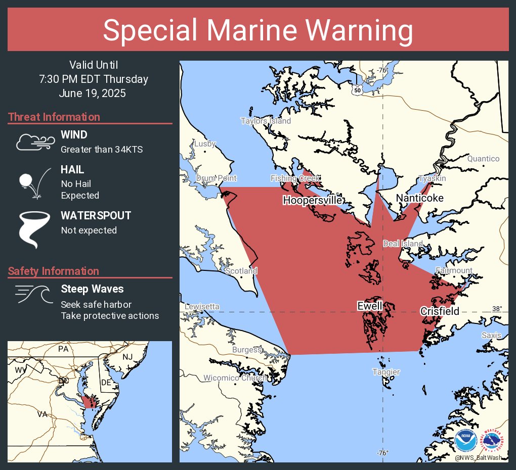
Special Marine Warning including the Chesapeake Bay from Drum Point MD to Smith Point VA and Tangier Sound and the inland waters surrounding Bloodsworth Island until 7:30 PM EDT

Special Marine Warning including the Chesapeake Bay from Drum Point MD to Smith Point VA and Tangier Sound and the inland waters surrounding Bloodsworth Island until 7:30 PM EDT
NWS Baltimore-Washington (@nws_baltwash) 's Twitter Profile Photo

Following an active weather day, calmer skies have moved in for sunset. Other than a few passing sprinkles this evening, dry conditions are expected overnight.

Following an active weather day, calmer skies have moved in for sunset.  Other than a few passing sprinkles this evening, dry conditions are expected overnight.
NWS Baltimore-Washington (@nws_baltwash) 's Twitter Profile Photo

A dry pattern sets up for the next several days, but with increasing heat starting this weekend. Well above normal temperatures are looking likely from Sunday through Wednesday. Afternoon heat indices approach 100-110 degrees at times during this period. #MDwx #VAwx #DCwx #WVwx

A dry pattern sets up for the next several days, but with increasing heat starting this weekend. Well above normal temperatures are looking likely from Sunday through Wednesday.  Afternoon heat indices approach 100-110 degrees at times during this period. #MDwx #VAwx #DCwx #WVwx
NWS Baltimore-Washington (@nws_baltwash) 's Twitter Profile Photo

High clouds this evening will be on the decease through the second half of the night. Some patchy fog may also be possible toward daybreak, especially in river valleys.

High clouds this evening will be on the decease through the second half of the night. Some patchy fog may also be possible toward daybreak, especially in river valleys.
NWS Baltimore-Washington (@nws_baltwash) 's Twitter Profile Photo

A lengthy period of above normal temperatures are expected into much of next week. Daily records are possible, particularly on Mon & Tue. Little to no relief is anticipated at night with lows in the mid 70s to near 80. Check out some heat safety info at: weather.gov/safety/heat

A lengthy period of above normal temperatures are expected into much of next week. Daily records are possible, particularly on Mon & Tue. Little to no relief is anticipated at night with lows in the mid 70s to near 80. Check out some heat safety info at: weather.gov/safety/heat
NWS Baltimore-Washington (@nws_baltwash) 's Twitter Profile Photo

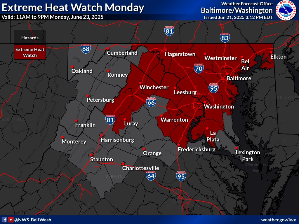
A prolonged period hot & humid conditions begins Sunday and persist through at least Thursday. Heat indices of 100-110 are likely each day. Heat Advisory in effect Sunday & an Extreme Heat Watch in effect Monday, for parts of the area. Find the latest at weather.gov/lwx

A prolonged period hot & humid conditions begins Sunday and persist through at least Thursday. Heat indices of 100-110 are likely each day. 

Heat Advisory in effect Sunday & an Extreme Heat Watch in effect Monday, for parts of the area. Find the latest at weather.gov/lwx