Nashville VOAD (@nashvillevoad) 's Twitter Profile
Nashville VOAD

@nashvillevoad

Voluntary Organizations Active in Disaster: A community disaster preparedness/response/recovery collective serving Davidson County. #NashvilleResponds

ID: 1398013207671943168

linkhttps://www.nashvilleresponds.com calendar_today27-05-2021 20:28:43

1,1K Tweet

656 Followers

189 Following

Nashville VOAD (@nashvillevoad) 's Twitter Profile Photo

Mayor Freddie O’Connell has provided the following video to update you on the current situation, what may be coming, and how to get up-to-date information on what you'll need to know now!
NashSevereWx (@nashseverewx) 's Twitter Profile Photo

Very Low Severe Threat Today, Additional Flooding & Severe Concerns Saturday. New blog here nashvillesevereweather.com/2025/04/04/ver…

Very Low Severe Threat Today, Additional Flooding & Severe Concerns Saturday. New blog here nashvillesevereweather.com/2025/04/04/ver…
NashSevereWx (@nashseverewx) 's Twitter Profile Photo

OHX issues Tornado Watch for Cheatham, Davidson, Dickson, Hickman, Houston, Humphreys, Lewis, Maury, Montgomery, Perry, Robertson, Stewart, Wayne, Williamson [TN] till Apr 4, 10:00 PM CDT mesonet.agron.iastate.edu/vtec/f/2025-O-…

OHX issues Tornado Watch for Cheatham, Davidson, Dickson, Hickman, Houston, Humphreys, Lewis, Maury, Montgomery, Perry, Robertson, Stewart, Wayne, Williamson [TN] till Apr 4, 10:00 PM CDT mesonet.agron.iastate.edu/vtec/f/2025-O-…
NashSevereWx (@nashseverewx) 's Twitter Profile Photo

Storm fuel is plentiful this afternoon. So is shear/helicity. Much more favorable tornado environments run from Ark. (!!! yikes) into NW Tenn. and NW Middle Tenn. We run a bit on the fringes for it but certainly agree today/tonight's atmosphere now warrants a "pay attention"

Storm fuel is plentiful this afternoon. So is shear/helicity.  Much more favorable tornado environments run from Ark. (!!! yikes) into NW Tenn. and NW Middle Tenn. We run a bit on the fringes for it but certainly agree today/tonight's atmosphere now warrants a "pay attention"
Nashville VOAD (@nashvillevoad) 's Twitter Profile Photo

It's nice to wake up to a break in the storms, BUT it's not over yet. Main concerns switch to flooding over the next 48 hours or so. Make sure you are prepared and check out tips from FEMA below: cdn.prod.website-files.com/6397da7fbd7f15…

It's nice to wake up to a break in the storms, BUT it's not over yet. Main concerns switch to flooding over the next 48 hours or so. Make sure you are prepared and check out tips from FEMA below: cdn.prod.website-files.com/6397da7fbd7f15…
Nashville VOAD (@nashvillevoad) 's Twitter Profile Photo

Es bueno despertarse con una pausa en las tormentas, PERO aún no ha terminado. Las principales preocupaciones ahora son las inundaciones durante las próximas 48 horas. Asegúrate de estar preparado y consulta los consejos de FEMA aquí: cdn.prod.website-files.com/6397da7fbd7f15…

Es bueno despertarse con una pausa en las tormentas, PERO aún no ha terminado. Las principales preocupaciones ahora son las inundaciones durante las próximas 48 horas. Asegúrate de estar preparado y consulta los consejos de FEMA aquí:

cdn.prod.website-files.com/6397da7fbd7f15…
NashSevereWx (@nashseverewx) 's Twitter Profile Photo

OHX issues Flash Flood Warning [flash flood: radar indicated] for Bedford, Hickman, Marshall, Maury, Rutherford, Williamson, Wilson [TN] till Apr 5, 11:45 PM CDT mesonet.agron.iastate.edu/vtec/f/2025-O-…

OHX issues Flash Flood Warning [flash flood: radar indicated] for Bedford, Hickman, Marshall, Maury, Rutherford, Williamson, Wilson [TN] till Apr 5, 11:45 PM CDT mesonet.agron.iastate.edu/vtec/f/2025-O-…
NashSevereWx (@nashseverewx) 's Twitter Profile Photo

Frost/Freeze Likely Tonight, Low Chance of a Strong Storm on Thursday. Deets here nashvillesevereweather.com/2025/04/08/fro…

NashSevereWx (@nashseverewx) 's Twitter Profile Photo

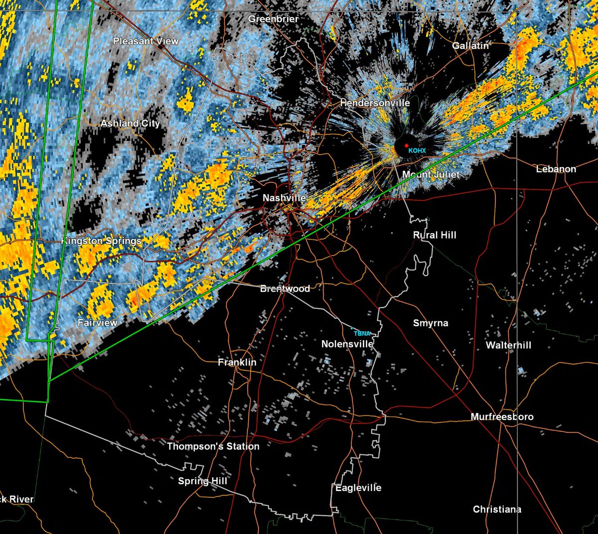
Small hail in all these purples from Riverwalk down to Fairview / 1239 PM / Winds and tornado unlikely in these. We are live here: youtube.com/watch?v=dOKg7b…

Small hail in all these purples from Riverwalk down to Fairview / 1239 PM / Winds and tornado unlikely in these. We are live here: youtube.com/watch?v=dOKg7b…
NashSevereWx (@nashseverewx) 's Twitter Profile Photo

Lightning is striking about 5 miles ahead of the storm itself. Get inside. Don't wait for the rain before you shelter from lightning. Lightning shelter is a fully enclosed structure / 1256 PM / We are live here: youtube.com/watch?v=dOKg7b…

NashSevereWx (@nashseverewx) 's Twitter Profile Photo

Strongest hail storm in Bells Bend moving east-northeast toward the north loop of Briley Pkwy / 1258 PM / We are live here: youtube.com/watch?v=dOKg7b…

Strongest hail storm in Bells Bend moving east-northeast toward the north loop of Briley Pkwy / 1258 PM / We are live here: youtube.com/watch?v=dOKg7b…
NashSevereWx (@nashseverewx) 's Twitter Profile Photo

We cannot reliably answer route, activity, and time specific questions because storm evolution tomorrow is unknown and conditional. We do not want you to make plans that look good now but put you in danger tmrw. Bottom line: do not leave yourself exposed and vulnerable with

NashSevereWx (@nashseverewx) 's Twitter Profile Photo

My immediate concern is the tornado-warned storm now approaching Centerville heading into Williamson County. It may be cycling which would cause tornado danger for Western Williamson Co, into Franklin, Cool Springs, Brentwood. Everyone in Will Co, heads up. Davidson Co, be ready,

NashSevereWx (@nashseverewx) 's Twitter Profile Photo

Updated ETAs for the worst part of this storm, but expect lightning and rain before these times / 405 PM / We are live here, hoping this is only a hail and wind event youtube.com/watch?v=tpW8xR…

Updated ETAs for the worst part of this storm, but expect lightning and rain before these times / 405 PM / We are live here, hoping this is only a hail and wind event youtube.com/watch?v=tpW8xR…
NashSevereWx (@nashseverewx) 's Twitter Profile Photo

Very large hail incoming to Leiper's Fork, Westhaven, Franklin, Thompson's Station, Spring Hill, Cool Springs, Brentwood, parts of South Nashville. As big as baseballs! / We are live here explaining why your phones went off youtube.com/watch?v=tpW8xR…

Very large hail incoming to Leiper's Fork, Westhaven, Franklin, Thompson's Station, Spring Hill, Cool Springs, Brentwood, parts of South Nashville. As big as baseballs! / We are live here explaining why your phones went off youtube.com/watch?v=tpW8xR…
Nashville VOAD (@nashvillevoad) 's Twitter Profile Photo

Don't Miss Out!!! On Mon. 6/23 from 12 - 1:30 pm, representatives from Mid TN will share and discuss key takeaways from various sessions at the 2025 National VOAD Conference. Please feel free to share it with others in your network. Register at: forms.gle/Zz5GDgEwFfn3BM…

Don't Miss Out!!!

On Mon. 6/23 from 12 - 1:30 pm, representatives from Mid TN will share and discuss key takeaways from various sessions at the 2025 National VOAD Conference. Please feel free to share it with others in your network.

Register at: forms.gle/Zz5GDgEwFfn3BM…