Ordnance Survey (@ordnancesurvey) 's Twitter Profile
Ordnance Survey

@ordnancesurvey

Britain's mapping agency. Helping you #SeeABetterPlace with world-leading location expertise. Get outside with @OSLeisure.
Online 9-5 Mon-Fri.

ID: 22614266

linkhttp://www.os.uk calendar_today03-03-2009 12:05:01

63,63K Tweet

59,59K Followers

2,2K Following

Maggie Jones (@whitchurchgirl) 's Twitter Profile Photo

Great to visit Ordnance Survey and see the fantastic work they're doing with data. ๐Ÿ“ŠThe great wealth of talent and creativity I saw shows how data can be used to create transformative products to improve peopleโ€™s lives.

Great to visit <a href="/OrdnanceSurvey/">Ordnance Survey</a> and see the fantastic work they're doing with data. ๐Ÿ“ŠThe great wealth of talent and creativity I saw shows how data can be used to create transformative products to improve peopleโ€™s lives.
Ordnance Survey (@ordnancesurvey) 's Twitter Profile Photo

The OS National Geographic Database contains new data on roofs, including presence of solar panels - providing valuable insights for various sectors, including sustainability, insurance, and urban planning. Now available on the OS Data Hub: ow.ly/59Fq50VxZtB

Maggie Jones (@whitchurchgirl) 's Twitter Profile Photo

People often think that Ordnance Survey is just about maps, but they're transforming data to improve people's lives. When I visited their office, I was able to see some of the impressive & imaginative work being done.

Satellite Applications Catapult (@satappscatapult) 's Twitter Profile Photo

We were proud to take part in the #CambridgeConference earlier this week, Ordnance Surveyโ€™s prestigious biennial gathering of national mapping agencies from around the world to explore the role of geospatial insight in addressing global challenges.
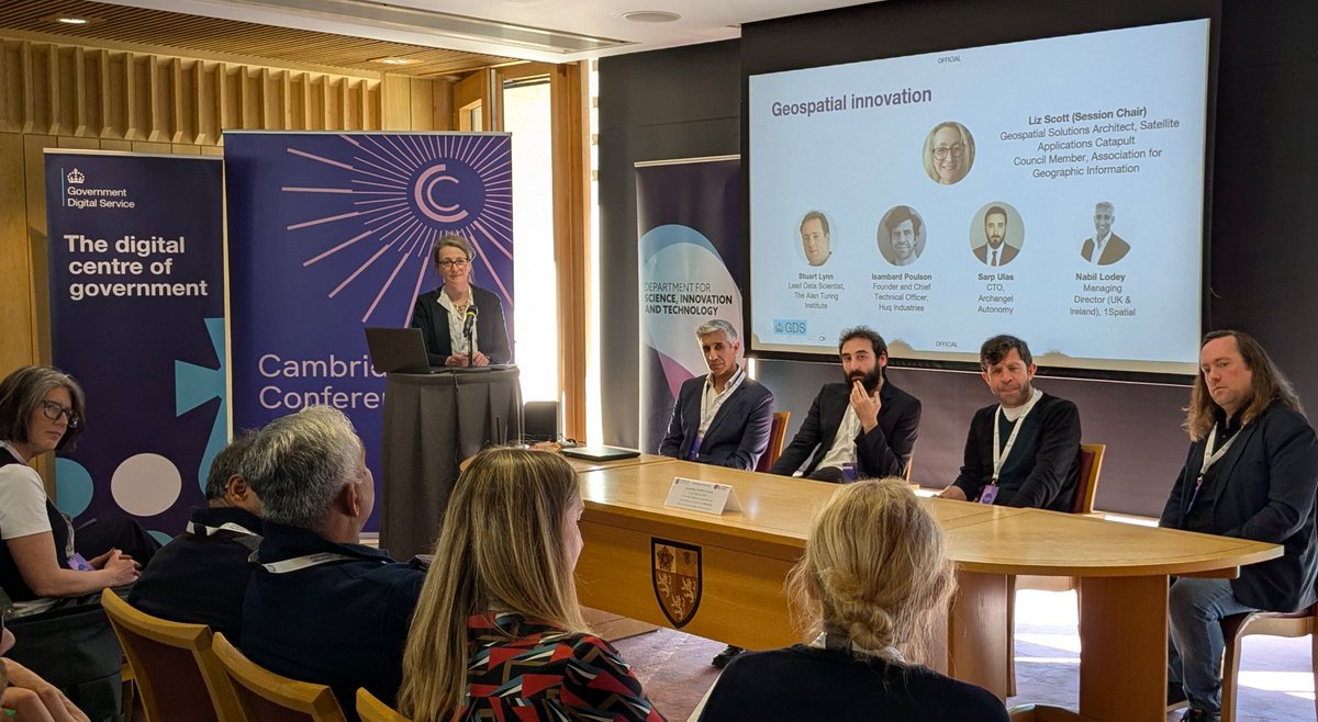
We were proud to take part in the #CambridgeConference earlier this week, <a href="/OrdnanceSurvey/">Ordnance Survey</a>โ€™s prestigious biennial gathering of national mapping agencies from around the world to explore the role of geospatial insight in addressing global challenges.
Ordnance Survey (@ordnancesurvey) 's Twitter Profile Photo

We welcomed Minister for the Future Digital Economy and Online Safety, Maggie Jones Department for Science, Innovation and Technology to OS HQ, sharing the capabilities of OS data and how it's improving people's lives on a daily basis. Maggie Jones GDS

Ordnance Survey (@ordnancesurvey) 's Twitter Profile Photo

OS initiative Geovation and Ministry of Housing, Communities & Local Gov have launched a ยฃ1.2M PropTech Innovation Challenge to accelerate the delivery of 1.5 million new homes. Register your interest: ow.ly/BwCt50VAa0P

OS initiative <a href="/Geovation/">Geovation</a> and <a href="/mhclg/">Ministry of Housing, Communities & Local Gov</a> have launched a ยฃ1.2M PropTech Innovation Challenge to accelerate the delivery of 1.5 million new homes.

Register your interest: ow.ly/BwCt50VAa0P
Ordnance Survey (@ordnancesurvey) 's Twitter Profile Photo

Access point data for key public buildings is now live on OS NGD. Crucial for emergency planning, situational awareness, and accessibility. Available on the OS Data Hub: ow.ly/1UW750VAILt

Ordnance Survey (@ordnancesurvey) 's Twitter Profile Photo

Data released by Mountain Rescue England and Wales shows a dramatic growth in rescue call-outs over the past five years. With the right maps, route planning, and navigation skills - we can all enjoy the outdoors safely and confidently: ow.ly/o2cl50VBtr5
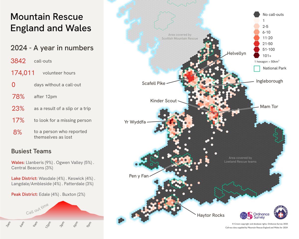
Data released by <a href="/MountainResqUK/">Mountain Rescue England and Wales</a> shows a dramatic growth in rescue call-outs over the past five years.

With the right maps, route planning, and navigation skills - we can all enjoy the outdoors safely and confidently: ow.ly/o2cl50VBtr5
Ordnance Survey (@ordnancesurvey) 's Twitter Profile Photo

Ever wondered what's inside a trig pillar? ๐Ÿ’ก Built in the 1930's, these concrete pillars helped OS map Great Britain with incredible accuracy, using triangulation. Once vital to surveying, they've now become iconic landmarks for walkers and map-lovers alike. #TrigWeek

Ordnance Survey (@ordnancesurvey) 's Twitter Profile Photo

Happy 89th birthday to the trig pillar! ๐ŸŽ‚ First installed in 1936, trig pillars have played a vital role in mapping Great Britain and remain a much-loved part of the landscape. Discover how we've also recreated Great Britain in Minecraft: ow.ly/46tk50VCqjC

Ordnance Survey (@ordnancesurvey) 's Twitter Profile Photo

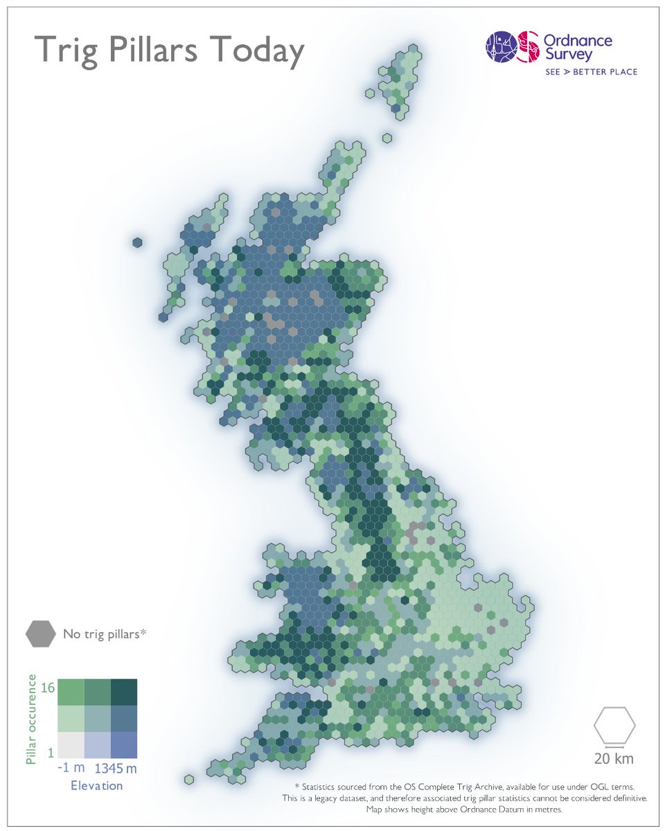
It's #TrigWeek! ๐ŸŽ‰ This gridded cartogram uses data from the OS Complete Trig Archive (a legacy dataset) - revealing how trig pillar density relates to elevation across Great Britain.

It's #TrigWeek! ๐ŸŽ‰

This gridded cartogram uses data from the OS Complete Trig Archive (a legacy dataset) - revealing how trig pillar density relates to elevation across Great Britain.
Ordnance Survey (@ordnancesurvey) 's Twitter Profile Photo

Happy Easter! You could fit approximately 1.6 million mini eggs around the Isle of Eigg, only slightly more than we'll be eating this weekend. That's a sweet 32.72km.๐Ÿซ If you prefer Creme Eggs, you could fit 654k around the same island.

Happy Easter! You could fit approximately 1.6 million mini eggs around the Isle of Eigg, only slightly more than we'll be eating this weekend. That's a sweet 32.72km.๐Ÿซ

If you prefer Creme Eggs, you could fit 654k around the same island.
Ordnance Survey (@ordnancesurvey) 's Twitter Profile Photo

This Earth Day, our data viz team has mapped where Britain's renewable energy is thriving. ๐ŸŒ #OurPowerOurPlanet #EarthDay2025

This Earth Day, our data viz team has mapped where Britain's renewable energy is thriving. ๐ŸŒ 
#OurPowerOurPlanet #EarthDay2025
Ordnance Survey (@ordnancesurvey) 's Twitter Profile Photo

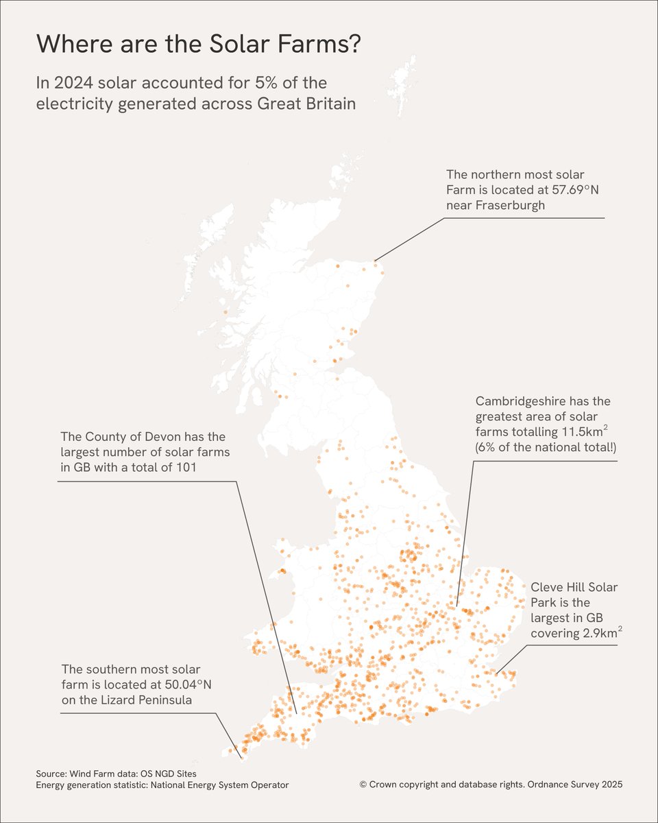
Our latest OS NGD data reveals where solar panels are most common across GB. โ˜€๏ธ These new insights, backed by OS data, are helping to drive smarter energy planning and sustainability efforts: ow.ly/5z7G50VGUAt

Ordnance Survey (@ordnancesurvey) 's Twitter Profile Photo

Exciting news for #Minecraft gamers! OS has brought the detailed world of Great Britain to Minecraft! ๐ŸŽฎ Explore stunning landscapes, from London to the Scottish Highlands, in incredible detail: ow.ly/jg6150VGY2h

Ordnance Survey (@ordnancesurvey) 's Twitter Profile Photo

The Thames Tideway Tunnel project, supported by Landmark Information Group and powered by OS data, is revolutionising river management to prevent sewage pollution, and promote biodiversity: ow.ly/rm2850VJIUJ

The Thames Tideway Tunnel project, supported by <a href="/LandmarkUK/">Landmark Information Group</a> and powered by OS data, is revolutionising river management to prevent sewage pollution, and promote biodiversity: ow.ly/rm2850VJIUJ
Ordnance Survey (@ordnancesurvey) 's Twitter Profile Photo

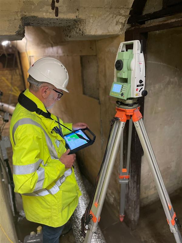
Surveying a secret Second World War bunker in Folkestone that used to relay Enigma messages to Bletchley Park: ow.ly/ZYAN50VLc4c ๐Ÿ”

Surveying a secret Second World War bunker in Folkestone that used to relay Enigma messages to Bletchley Park: ow.ly/ZYAN50VLc4c ๐Ÿ”
Ordnance Survey (@ordnancesurvey) 's Twitter Profile Photo

British Minecraft fans, access a detailed Minecraft world of Great Britain with OS OpenData - your street, your town, block by block. Download and explore: ow.ly/6HNL50VLTyr