PA Climate Office (@paclimateoffice) 's Twitter Profile
PA Climate Office

@paclimateoffice

ID: 372325111

linkhttp://climate.met.psu.edu calendar_today12-09-2011 15:27:56

836 Tweet

353 Followers

25 Following

PA Climate Office (@paclimateoffice) 's Twitter Profile Photo

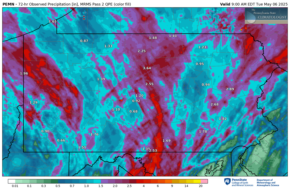
With the persistent rains over the past several days, several inches have fallen at various spots across the state. The most rain from our PA Environmental Monitoring Network over the past 72 hours is Keystone Central School District in Clinton Co. observing 3.64". #PAwx

With the persistent rains over the past several days, several inches have fallen at various spots across the state.  The most rain from our PA Environmental Monitoring Network over the past 72 hours is Keystone Central School District in Clinton Co. observing 3.64". #PAwx
Weather World (@weatherworldpsu) 's Twitter Profile Photo

Did you know that PA Climate Office recently worked together with educators to come up with K-12 curriculum about the #KeystoneMesonet? Rob Lydick chats w/ the PA State Climatologist about these new resources: youtu.be/P6D-iYg56Fw keystone-mesonet.org WPSU College of EMS PCN

NWS State College (@nwsstatecollege) 's Twitter Profile Photo

Yesterday's high temperature of 57 degrees at Harrisburg International Airport ties the record lowest high temperature for May 28, previously set in 1968 and 1996. The period of record spans back to 1889.

PA Climate Office (@paclimateoffice) 's Twitter Profile Photo

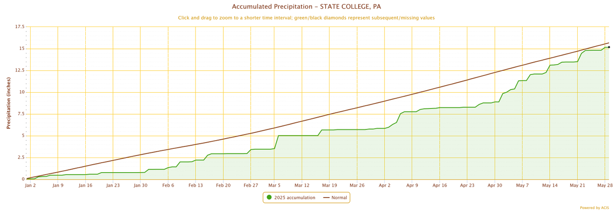
While it has been a relatively wet Spring across Central PA, State College is still running just under a half of an inch below normal for year-to-date accumulated precipitation. #PAwx

While it has been a relatively wet Spring across Central PA, State College is still running just under a half of an inch below normal for year-to-date accumulated precipitation. #PAwx
PA Climate Office (@paclimateoffice) 's Twitter Profile Photo

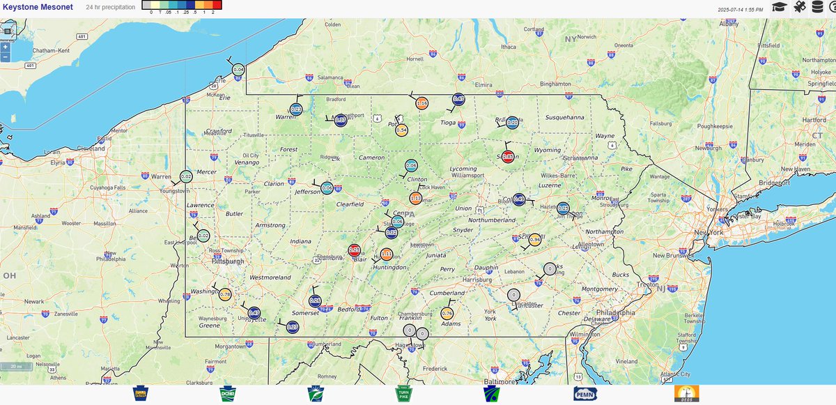
Precipitation totals are increasing quickly across parts of central and eastern PA with slow-moving thunderstorms capable of producing heavy rain throughout the afternoon/evening. Plenty of statewide data available at keystone-mesonet.org . #pawx

Precipitation totals are increasing quickly across parts of central and eastern PA with slow-moving thunderstorms capable of producing heavy rain throughout the afternoon/evening.  Plenty of statewide data available at keystone-mesonet.org . #pawx
PA Climate Office (@paclimateoffice) 's Twitter Profile Photo

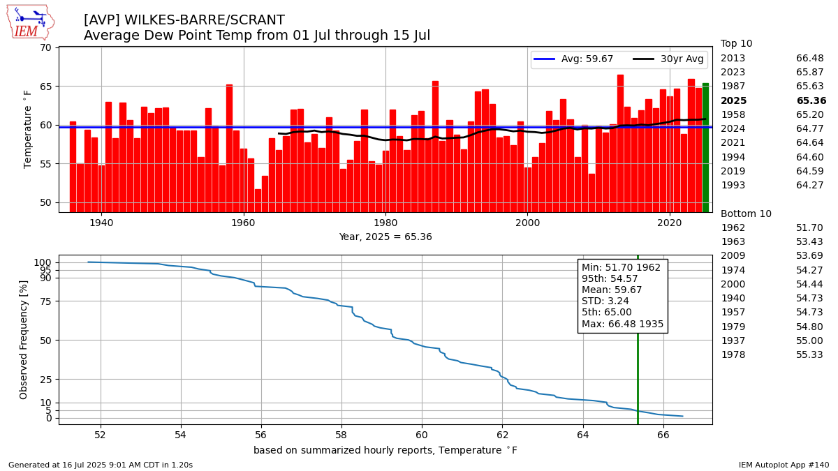
Has it felt abnormally humid recently? In fact, it has been across PA! Through the first half of July, dew points have been in the top 3 to top 5 highest on record at many reporting sites. A few select sites are shown below, courtesy of the IEM website. #PAwx

Has it felt abnormally humid recently? In fact, it has been across PA! Through the first half of July, dew points have been in the top 3 to top 5 highest on record at many reporting sites.  A few select sites are shown below, courtesy of the IEM website. #PAwx
PA Climate Office (@paclimateoffice) 's Twitter Profile Photo

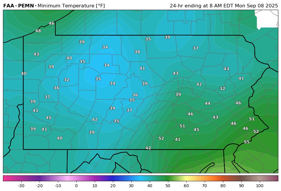
A chilly morning for the state with most observing sites across western PA dipping into the mid-upper 30s, with frosty ground across north-central PA. #PAwx

A chilly morning for the state with most observing sites across western PA dipping into the mid-upper 30s, with frosty ground across north-central PA. #PAwx
NWS State College (@nwsstatecollege) 's Twitter Profile Photo

Here's a quick timelapse of a couple substorms at Williamson High School. Track it here: climate.met.psu.edu/data/pemn/?sit… #PAwx

PA Climate Office (@paclimateoffice) 's Twitter Profile Photo

26 years ago on Sep. 16-17, 1999, Hurricane Floyd traversed the eastern seaboard of the United States, bringing impactful rainfall that broke daily precipitation records in Philadelphia. Image courtesy of National Weather Service. #PAwx
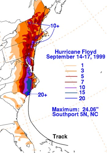
26 years ago on Sep. 16-17, 1999, Hurricane Floyd traversed the eastern seaboard of the United States, bringing impactful rainfall that broke daily precipitation records in Philadelphia.  Image courtesy of <a href="/NWS/">National Weather Service</a>. #PAwx
PA Climate Office (@paclimateoffice) 's Twitter Profile Photo

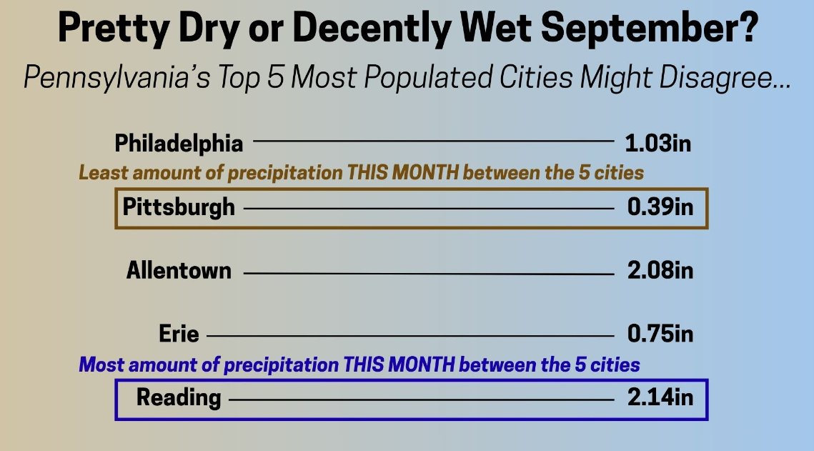
Prior to the recent rain, many observing sites (especially across western PA) have been very try. As of 9/21, here are the rainfall totals month-to-date from the top 5 most populous PA cities. Some much-needed rain occurring now with more on the way! #PAwx

Prior to the recent rain, many observing sites (especially across western PA) have been very try.  As of 9/21, here are the rainfall totals month-to-date from the top 5 most populous PA cities.  Some much-needed rain occurring now with more on the way! #PAwx
PA Climate Office (@paclimateoffice) 's Twitter Profile Photo

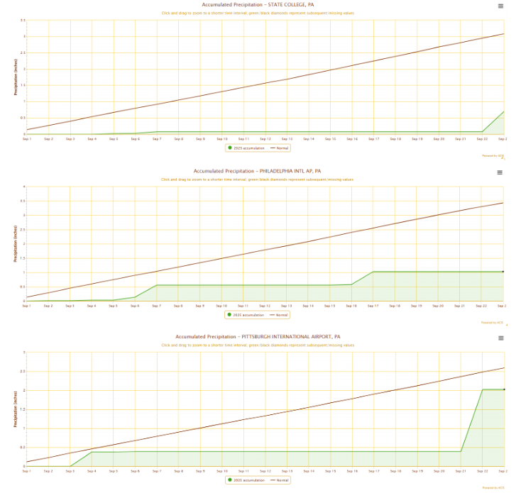
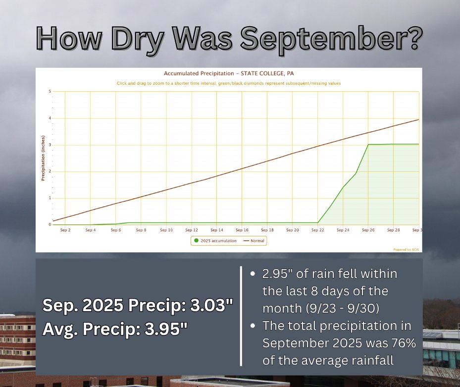
And more perspective on the dry conditions, month-to-date rainfall accumulations for Pittsburgh, Philly, and State College below illustrate the precipitation deficits since 9/1. #PAwx

And more perspective on the dry conditions, month-to-date rainfall accumulations for Pittsburgh, Philly, and State College below illustrate the precipitation deficits since 9/1. #PAwx
PA Climate Office (@paclimateoffice) 's Twitter Profile Photo

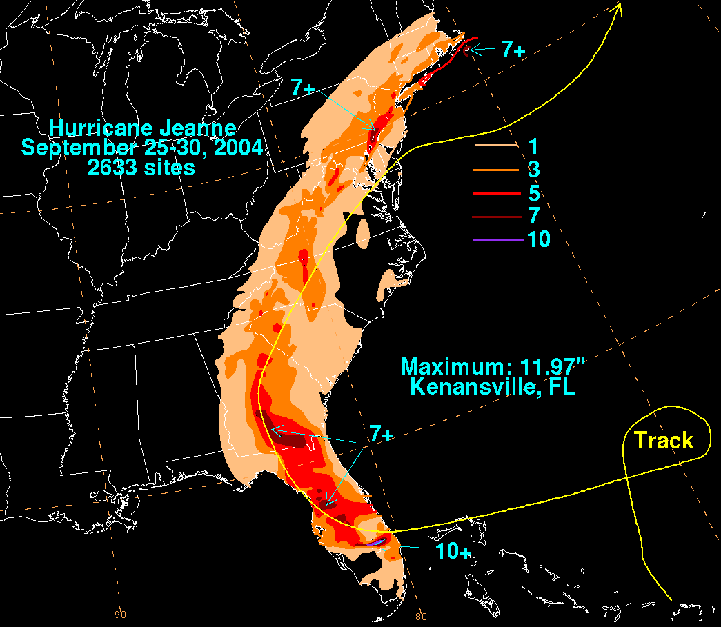
21 years ago, the remnants of Hurricane Jeane produced over 7" of rain in the Philly region and over an inch for much of the state. The rainfall and flooding caused an estimated $145m in damage to the state. PA reported the 2nd highest damage costs, only behind FL for the event.

21 years ago, the remnants of Hurricane Jeane produced over 7" of rain in the Philly region and over an inch for much of the state. The rainfall and flooding caused an estimated $145m in damage to the state. PA reported the 2nd highest damage costs, only behind FL for the event.
PA Climate Office (@paclimateoffice) 's Twitter Profile Photo

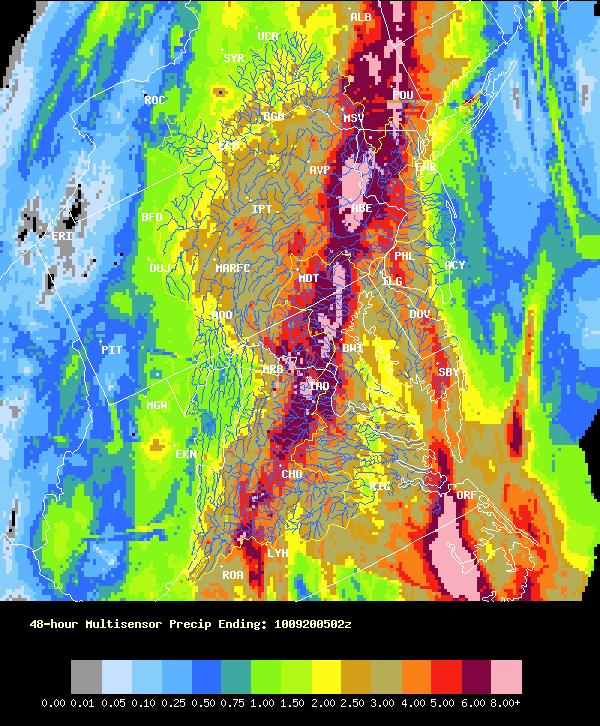
20 years ago, the remnants of T.S. Tammy interacted with a cold front over PA, which led to 2-5" of rain falling over most of the state. The most rain was observed in a long northeast-southwest strip near Lancaster, where 8-12" of rain fell. Image source from NWS State College.

20 years ago, the remnants of T.S. Tammy interacted with a cold front over PA, which led to 2-5" of rain falling over most of the state. The most rain was observed in a long northeast-southwest strip near Lancaster, where 8-12" of rain fell. Image source from NWS State College.
PA Climate Office (@paclimateoffice) 's Twitter Profile Photo

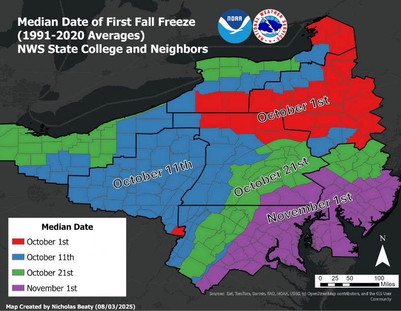
Many areas this morning are at or below the freezing mark across northern and western PA. Compared to the average date of the first Fall freeze, many spots are near the climatological time for this occurrence (though some isolated areas did get near freezing in early Sept).

Many areas this morning are at or below the freezing mark across northern and western PA.  Compared to the average date of the first Fall freeze, many spots are near the climatological time for this occurrence (though some isolated areas did get near freezing in early Sept).
PA Climate Office (@paclimateoffice) 's Twitter Profile Photo

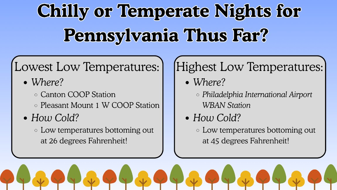
Nighttime temperatures can vary significantly, particularly during this time of year. Just a few nights ago, on Oct.10, the lowest overnight reading was 26°F in northern PA, whereas the Philadelphia region was 45°F. Both areas were well below normal, but nearly 20°F difference!

Nighttime temperatures can vary significantly, particularly during this time of year.  Just a few nights ago, on Oct.10, the lowest overnight reading was 26°F in northern PA, whereas the Philadelphia region was 45°F.  Both areas were well below normal, but nearly 20°F difference!
PA Climate Office (@paclimateoffice) 's Twitter Profile Photo

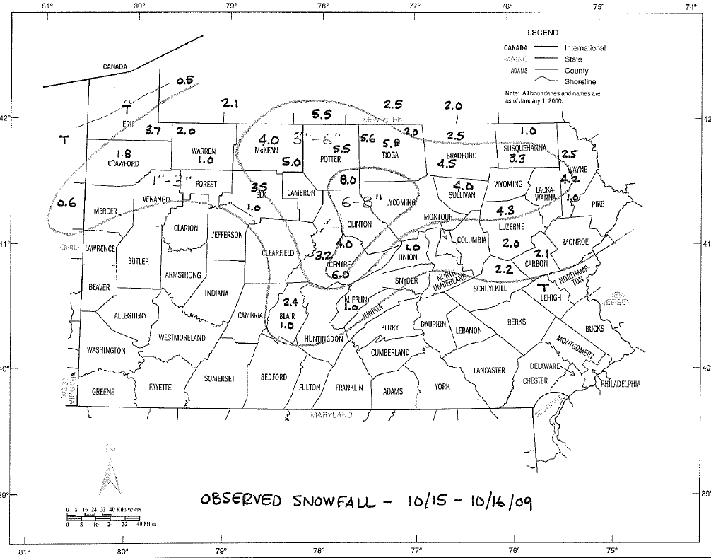
16 years ago, a very early season snowstorm brought heavy, wet snow and several power outages/trees down across northern and central PA. #PAwx

16 years ago, a very early season snowstorm brought heavy, wet snow and several power outages/trees down across northern and central PA. #PAwx
PA Climate Office (@paclimateoffice) 's Twitter Profile Photo

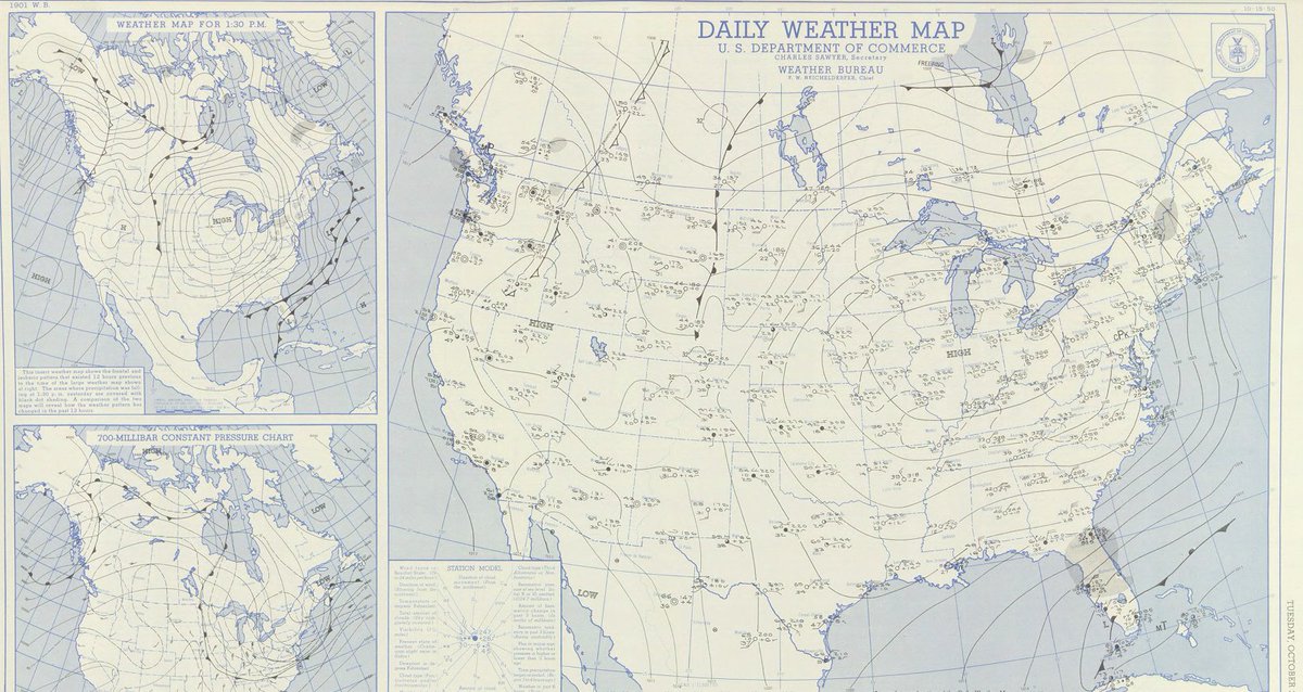
73 years ago today, the lowest temperature ever recorded during the month of October in Pennsylvania (7°F) occurred in Coudersport. A strong anticyclone to the west of PA behind a strong arctic cold front brought northwesterly flow and colder air to the region. #PAwx

73 years ago today, the lowest temperature ever recorded during the month of October in Pennsylvania (7°F) occurred in Coudersport.  A strong anticyclone to the west of PA behind a strong arctic cold front brought northwesterly flow and colder air to the region. #PAwx
PA Climate Office (@paclimateoffice) 's Twitter Profile Photo

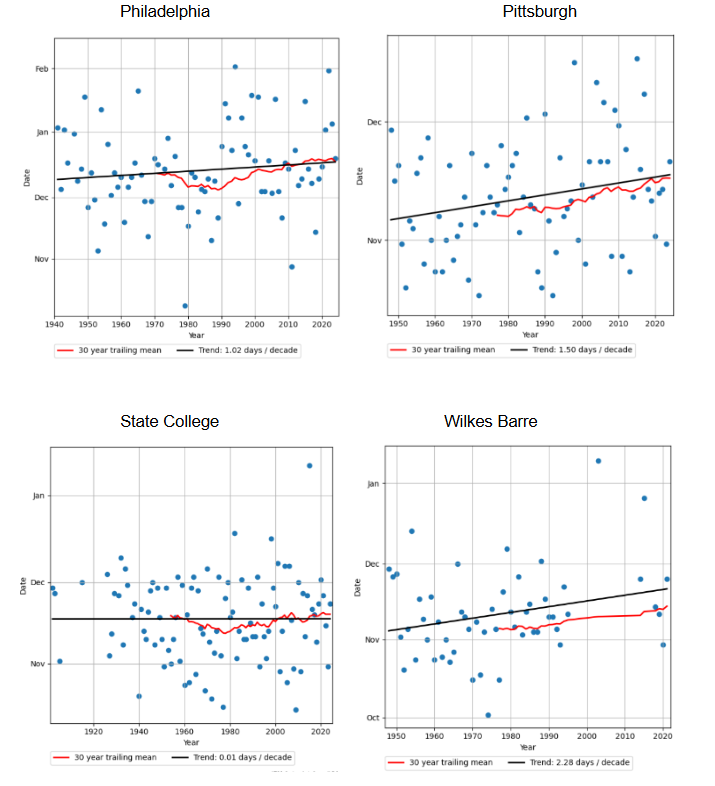
The first measurable snow of the season in PA is trending a tad later in the Fall over recent decades. The below image shows the trend for major observing sites, with State College standing out as having no noticeable trend in first snow date over recent decades. #PAwx

The first measurable snow of the season in PA is trending a tad later in the Fall over recent decades.  The below image shows the trend for major observing sites, with State College standing out as having no noticeable trend in first snow date over recent decades. #PAwx
PA Climate Office (@paclimateoffice) 's Twitter Profile Photo

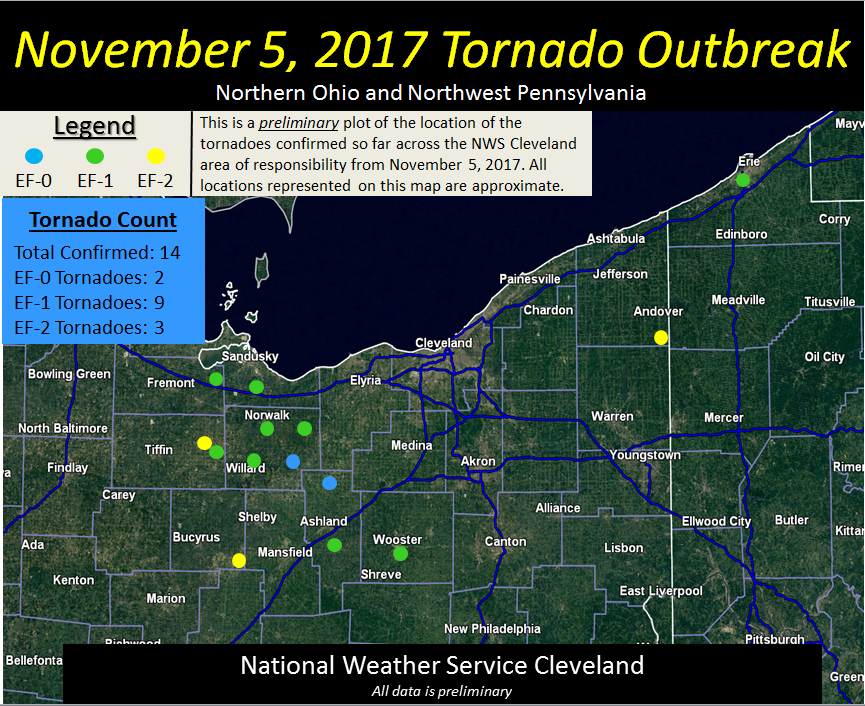
PA can still observe severe weather, and even tornadic storms, into November. 8 years ago today, an EF-1 tornado touched down in Erie, PA. Image courtesy of the NWS Cleveland office. #PAwx

PA can still observe severe weather, and even tornadic storms, into November. 8 years ago today, an EF-1 tornado touched down in Erie, PA. Image courtesy of the NWS Cleveland office. #PAwx