Patrick Duplessis (@pat_wx) 's Twitter Profile
Patrick Duplessis

@pat_wx

Météorologue à @meteomedia | DalU Physics Ph.D. Candidate | Canadian weather maps and stats | FR/EN

ID: 37463952

linkhttp://meteomedia.com calendar_today03-05-2009 17:59:40

4,4K Tweet

2,2K Followers

285 Following

Patrick Duplessis (@pat_wx) 's Twitter Profile Photo

Turns out this is the biggest 1-hour temperature drop on record for Bathurst airport (since data began in 1994)! Previous was 14.9°C on May 1, 1998.

Thierry Goose (@thierrygoosebc) 's Twitter Profile Photo

🌡️21.3°C Arviat, NU ➡️ NEW MONTHLY RECORD, breaking 21.2°C in 2023 🌡️24.4°C Yellowknife, NT, which could break its monthly record tomorrow 🌡️20.4°C Bathurst Inlet, NU Over 36°C in British Columbia [see previous tweet] and 32°C in Alberta Record heat is expected tomorrow in NT

🌡️21.3°C Arviat, NU ➡️ NEW MONTHLY RECORD, breaking 21.2°C in 2023

🌡️24.4°C Yellowknife, NT, which could break its monthly record tomorrow

🌡️20.4°C Bathurst Inlet, NU

Over 36°C in British Columbia [see previous tweet] and 32°C in Alberta

Record heat is expected tomorrow in NT
Thierry Goose (@thierrygoosebc) 's Twitter Profile Photo

‼️RECORD HEAT IN THE NORTHWEST TERRITORIES 🇨🇦‼️ 🌡️34.3°C Hay River [61°N] ➡️ MAY TERRITORIAL RECORD, breaking 33.3°C at the same station in 1948! MAY RECORDS DESTROYED 🌡️33.4°C Fort Smith 🌡️32.6°C Fort Providence & Łutselkʼe 🌡️30.2°C Whatì 🌡️28.7°C Yellowknife #NTstorm

‼️RECORD HEAT IN THE NORTHWEST TERRITORIES 🇨🇦‼️

🌡️34.3°C Hay River [61°N] ➡️ MAY TERRITORIAL RECORD, breaking 33.3°C at the same station in 1948!

MAY RECORDS DESTROYED
🌡️33.4°C Fort Smith
🌡️32.6°C Fort Providence & Łutselkʼe
🌡️30.2°C Whatì
🌡️28.7°C Yellowknife
#NTstorm
Patrick Duplessis (@pat_wx) 's Twitter Profile Photo

May 2025 was a bit of a mixed bag across Canada. Very warm in the Prairies and parts of the north. Very cool in Yukon and adjacent NWT, and cooler than normal in northern QC and southern ON. #wxtwitter

May 2025 was a bit of a mixed bag across Canada. Very warm in the Prairies and parts of the north. Very cool in Yukon and adjacent NWT, and cooler than normal in northern QC and southern ON. #wxtwitter
Thierry Goose (@thierrygoosebc) 's Twitter Profile Photo

Highest temperatures of the year in #Quebec today. 🌡️32.7°C Cap Rouge 🌡️32.5°C L'Assomption & Roberval 🌡️32.4°C Pointe Claveau 🌡️32.3°C Bagotville & Saint-Hubert 🌡️32.2°C La Baie & Normandin 🌡️32.1°C Jonquière, Laterrière & Sainte-Clotilde 🌡️31.5°C La Tuque & Saint-Anicet #QCwx

Highest temperatures of the year in #Quebec today.

🌡️32.7°C Cap Rouge
🌡️32.5°C L'Assomption & Roberval
🌡️32.4°C Pointe Claveau
🌡️32.3°C Bagotville & Saint-Hubert
🌡️32.2°C La Baie & Normandin
🌡️32.1°C Jonquière, Laterrière & Sainte-Clotilde
🌡️31.5°C La Tuque & Saint-Anicet
#QCwx
Thierry Goose (@thierrygoosebc) 's Twitter Profile Photo

‼️Record heat in Quebec‼️ JUNE RECORDS 🌡️36.6°C Gatineau, 0.8°C from all-time record 🌡️36.4°C L'Assomption, 0.8°C from ATR 🌡️35.7°C L'Acadie, 0.4°C from ATR 🌡️35.5°C St-Hubert 🌡️35.2°C St-Anicet 🌡️34.8°C Ste-Anne-de-Bellevue & Ste-Clotilde 🌡️34.0°C Nicolet #QCstorm (1/2)

‼️Record heat in Quebec‼️

JUNE RECORDS
🌡️36.6°C Gatineau, 0.8°C from all-time record
🌡️36.4°C L'Assomption, 0.8°C from ATR
🌡️35.7°C L'Acadie, 0.4°C from ATR
🌡️35.5°C St-Hubert
🌡️35.2°C St-Anicet
🌡️34.8°C Ste-Anne-de-Bellevue & Ste-Clotilde
🌡️34.0°C Nicolet

#QCstorm (1/2)
Thierry Goose (@thierrygoosebc) 's Twitter Profile Photo

‼️Exceptionally warm night in Quebec with widespread minimums over 25°C in and around Montreal. 🥵 🌡27.0°C in Sainte-Clotilde *could be* a new June record for Quebec and even for Canada outside of British Columbia, if it holds until 2 am local time. [TBC] #QCstorm #QCwc

‼️Exceptionally warm night in Quebec with widespread minimums over 25°C in and around Montreal. 🥵

🌡27.0°C in Sainte-Clotilde *could be* a new June record for Quebec and even for Canada outside of British Columbia, if it holds until 2 am local time. [TBC]
#QCstorm #QCwc
Patrick Duplessis (@pat_wx) 's Twitter Profile Photo

June 2025 was generally warmer than normal in Canada, although most stations were within 1° of their 1991-2020 normal. Atlantic Canada got the warmest anomalies, up to 3.5° above normal in St. John's, NL. #wxtwitter

June 2025 was generally warmer than normal in Canada, although most stations were within 1° of their 1991-2020 normal. Atlantic Canada got the warmest anomalies, up to 3.5° above normal in St. John's, NL. #wxtwitter
Rodney Barney (@rcbstormpost) 's Twitter Profile Photo

=NEW ALL TIME RECORD= High 34.9°C at #Badger today beats the old record of 34.7°C set Aug 10, 2001, for highest temp in the location's dataset (1956-2025). Lots of 30+°C highs on the island. As already mentioned, 33.6°C at Gander #YQX was warmest since Jul 9, 1952. #nlwx 🔥

=NEW ALL TIME RECORD=

High 34.9°C at #Badger today beats the old record of 34.7°C set Aug 10, 2001, for highest temp in the location's dataset (1956-2025).

Lots of 30+°C highs on the island. As already mentioned, 33.6°C at Gander #YQX was warmest since Jul 9, 1952. #nlwx 🔥
Thierry Goose (@thierrygoosebc) 's Twitter Profile Photo

Highest temperatures recorded today in BC. 40.0°C Lytton 39.4°C Ashcroft & Kamloops 38.9°C Pemberton 38.3°C Lillooet 38.2°C Warfield 38.0°C Osoyoos 37.2°C Nelson 37.1°C Clearwater 37.0°C Kelowna 36.9°C Merritt 36.8°C Penticton 36.7°C Princeton 36.2°C Castlegar 36.0°C Summerland

Highest temperatures recorded today in BC.

40.0°C Lytton
39.4°C Ashcroft & Kamloops
38.9°C Pemberton
38.3°C Lillooet
38.2°C Warfield
38.0°C Osoyoos
37.2°C Nelson
37.1°C Clearwater
37.0°C Kelowna
36.9°C Merritt
36.8°C Penticton
36.7°C Princeton
36.2°C Castlegar
36.0°C Summerland
Patrick Duplessis (@pat_wx) 's Twitter Profile Photo

July 2025 was a mixed bag in #Canada. Generally hotter than normal in the east, but slightly cooler in many regions. Northern Nunavut had the coldest anomalies, between 1° and 2°C below the 1991-2020 average. #wxtwitter

July 2025 was a mixed bag in #Canada. Generally hotter than normal in the east, but slightly cooler in many regions. Northern Nunavut had the coldest anomalies, between 1° and 2°C below the 1991-2020 average. #wxtwitter
Rodney Barney (@rcbstormpost) 's Twitter Profile Photo

=TIED MONTHLY RECORD= 🌡️ High of 35.3°C at Goose Bay (#YYR) today ties the August monthly extreme maximum, last set on Aug 8, 1996 (data since 1942). Also makes for the warmest Tmax since July 1, 2002. Warm to hot Monday across the province as the sizzling #NLwx continues.

=TIED MONTHLY RECORD=

🌡️ High of 35.3°C at Goose Bay (#YYR) today ties the August monthly extreme maximum, last set on Aug 8, 1996 (data since 1942). Also makes for the warmest Tmax since July 1, 2002.

Warm to hot Monday across the province as the sizzling #NLwx continues.
Patrick Duplessis (@pat_wx) 's Twitter Profile Photo

Multiple monthly and all-time heat records today in Eastern Canada! Up to 38.6°C in Miramichi, NB. ♨️ PEI all-time record shattered (38.1°) and Newfoundland all-time record tied (36.7°)! More details in quoted tweet from Thierry Goose
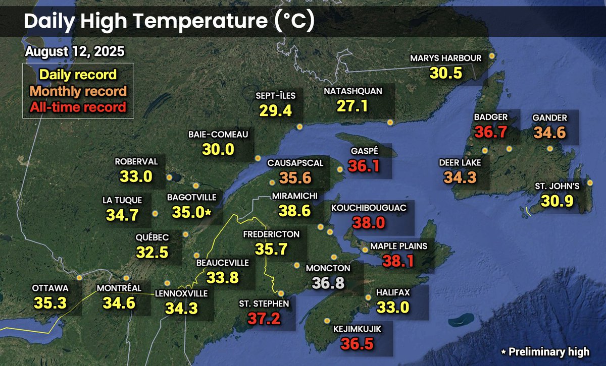
Multiple monthly and all-time heat records today in Eastern Canada! Up to 38.6°C in Miramichi, NB. ♨️
PEI all-time record shattered (38.1°) and Newfoundland all-time record tied (36.7°)! 
More details in quoted tweet from <a href="/ThierryGooseBC/">Thierry Goose</a>
Thierry Goose (@thierrygoosebc) 's Twitter Profile Photo

📉 Cool August night in Quebec with noticeably low min temperatures. -1.2°C Chouart [396 m] -1.0°C Wapus [329 m] ... 1.1°C Rouyn 1.5°C Chicoutimi 2.0°C Sherbrooke 2.9°C Trois-Rivières 3.4°C Quebec City YQB 6.2°C Mirabel 6.4°C Longueuil 6.5°C Gatineau 9.2°C Montreal YUL #QCstorm

📉 Cool August night in Quebec with noticeably low min temperatures.

-1.2°C Chouart [396 m]
-1.0°C Wapus [329 m]
...
1.1°C Rouyn
1.5°C Chicoutimi
2.0°C Sherbrooke
2.9°C Trois-Rivières
3.4°C Quebec City YQB
6.2°C Mirabel
6.4°C Longueuil
6.5°C Gatineau
9.2°C Montreal YUL
#QCstorm
Thierry Goose (@thierrygoosebc) 's Twitter Profile Photo

Also very hot in the Northwest Territories, at record level for late August. 🌡️34.7°C Yohin Lake [Sep. record is 33.1°C = NT Sep. record] 🌡️31.3°C Deadmen Valley [31.8°C yesterday], Fort Providence & Lindberg Landing 🌡️30.8°C Hay River The heat will last all week. #NTstorm

Also very hot in the Northwest Territories, at record level for late August.

🌡️34.7°C Yohin Lake [Sep. record is 33.1°C = NT Sep. record]

🌡️31.3°C Deadmen Valley [31.8°C yesterday], Fort Providence &amp; Lindberg Landing

🌡️30.8°C Hay River

The heat will last all week. #NTstorm