Meteorologist Peter Hall (@peteweatherbeat) 's Twitter Profile
Meteorologist Peter Hall

@peteweatherbeat

Emmy, NYS Associated Press & Syracuse Press Club award winning evening meteorologist for NBC3/WSTM/WSTQ & @CNYCentral since 1995.

ID: 36071917

linkhttps://www.youtube.com/c/MeteorologistPeterHall calendar_today28-04-2009 14:03:46

29,29K Tweet

6,6K Followers

210 Following

Meteorologist Peter Hall (@peteweatherbeat) 's Twitter Profile Photo

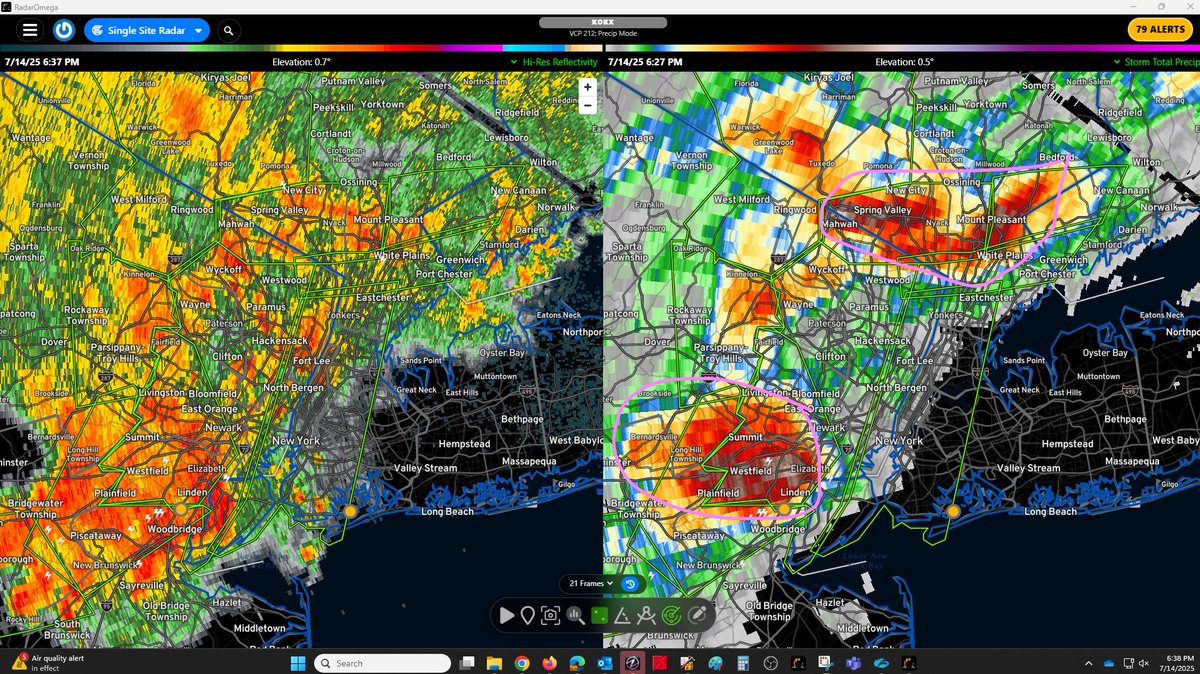
There is already flash flooding over parts of New Jersey and areas just north of NYC with 5-7"+ of estimated rain that has already fallen and more coming. A preemptive flash flood warning has now been issued for most of the 5 boroughs of NYC as very slow-moving downpours enters!

There is already flash flooding over parts of New Jersey and areas just north of NYC with 5-7"+ of estimated rain that has already fallen and more coming.

A preemptive flash flood warning has now been issued for most of the 5 boroughs of NYC as very slow-moving downpours enters!
Meteorologist Peter Hall (@peteweatherbeat) 's Twitter Profile Photo

If you or someone you know is flying through the airports of the northeast, you are going to have some big problems with delays and/or diversions due to very slow moving downpours and thunderstorms! The National Weather Desk The National Desk

Meteorologist Peter Hall (@peteweatherbeat) 's Twitter Profile Photo

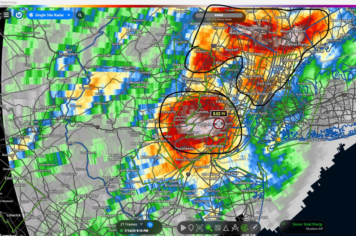
These black highlighted areas all saw at >=3" of rain with up to 7-8½ rain (white shades) in a short period of time, especially the northern half of NJ and from Manhattan north into Westchester & Orange counties, NY. These areas are where the worst flash flooding is occurring!

These black highlighted areas all saw at >=3" of rain with up to 7-8½ rain (white shades) in a short period of time, especially the northern half of NJ and from Manhattan north into Westchester & Orange counties, NY.

These areas are where the worst flash flooding is occurring!
Meteorologist Peter Hall (@peteweatherbeat) 's Twitter Profile Photo

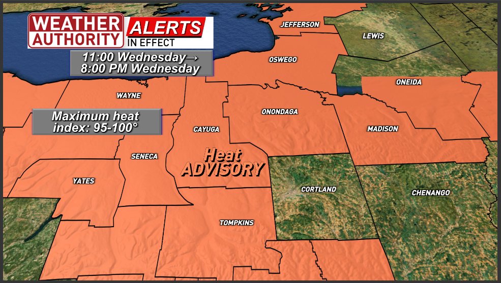
A Heat Advisory has been issued for Wednesday. Expect even higher maximum heat index values of 95-100° in the shade & on lawns during this period. It will feel even hotter in the sun & on pavement. Stay hydrated, take frequent breaks, keep pets indoors, check in on elderly!

A Heat Advisory has been issued for Wednesday.  Expect even higher maximum heat index values of 95-100° in the shade & on lawns during this period. It will feel even hotter in the sun & on pavement.

Stay hydrated, take frequent breaks, keep pets indoors, check in on elderly!
Meteorologist Peter Hall (@peteweatherbeat) 's Twitter Profile Photo

Get set for higher heat and humidity for Wednesday and Thursday. I'm also concerned about isolated to scattered thunderstorms, especially about Thursday! Find out the threats here! cnycentral.com/news/local/hea… The National Weather Desk Sean Carroll Matt Saffer

Ben Noll (@bennollweather) 's Twitter Profile Photo

There have been varying meteorological forces behind recent extreme rainfall events, but they are all connected by very unusual amounts of moisture pulsing above the United States. Precipitable water, a measure of the total amount of water in the atmosphere, has been above the

There have been varying meteorological forces behind recent extreme rainfall events, but they are all connected by very unusual amounts of moisture pulsing above the United States.

Precipitable water, a measure of the total amount of water in the atmosphere, has been above the
Meteorologist Peter Hall (@peteweatherbeat) 's Twitter Profile Photo

It's been one year since a tornado ripped through Rome with 135 MPH winds. I take a look back at what happened, what's changed, and what might be changed ahead. youtube.com/watch?v=-1IPVz… The National Weather Desk Sean Carroll Matt Saffer Ryan Hall, Y’all Max Velocity Reed Timmer, PhD

Meteorologist Peter Hall (@peteweatherbeat) 's Twitter Profile Photo

🚨Severe t-storm WARNING🚨 Until 10:45 PM yellow outlined areas. Storm movement in blue. DANGEROUS STORM circled IMPACTS: •DAMAGING wind of 60 MPH  •LOCALIZED trees & wires may be damaged •LOCAL POWER OUTAGES  •TORRENTIAL downpours  Radar/more: cnycentral.com

🚨Severe t-storm WARNING🚨

Until 10:45 PM yellow outlined areas. Storm movement in blue. DANGEROUS STORM circled 

IMPACTS:
•DAMAGING wind of 60 MPH 
•LOCALIZED trees & wires may be damaged
•LOCAL POWER OUTAGES 
•TORRENTIAL downpours 

Radar/more: cnycentral.com
Met4Cast (@met4castuk) 's Twitter Profile Photo

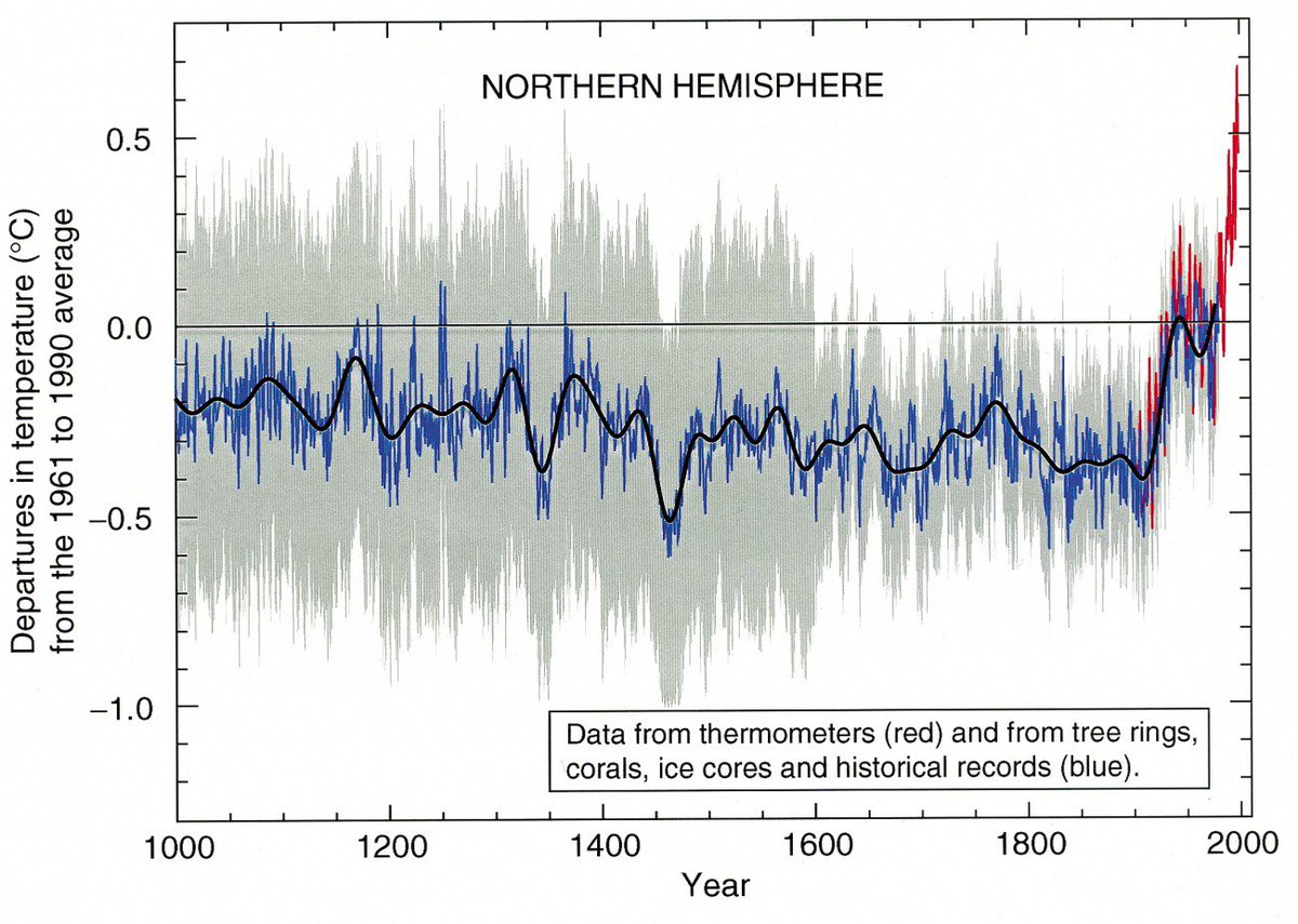
The idea that observed planetary warming is down to us coming out of an ice age is nonsense. Before the industrial revolution, global temperatures were falling with the next geological event being an ice age over the next 10-30 thousand years as a result of Milankovitch Cycles.

The idea that observed planetary warming is down to us coming out of an ice age is nonsense. 

Before the industrial revolution, global temperatures were falling with the next geological event being an ice age over the next 10-30 thousand years as a result of Milankovitch Cycles.
Meteorologist Peter Hall (@peteweatherbeat) 's Twitter Profile Photo

Relief from the heat and humidity is moving in right now. Find out how long that lasts and a look into Friday, the weekend and beyond which includes the forecast for the big Syracuse Nationals car show here: cnycentral.com/news/local/ref… The National Weather Desk Sean Carroll