Rob Mayeda (@robmayeda) 's Twitter Profile
Rob Mayeda

@robmayeda

Bay Area AMS Meteorologist since 2003 CSU/SJSU Lecturer. Formerly KIRO, KCRA, KSBY, KESQ, KNBC, Arizona Daily Wildcat & dad of twinados 👦🏻🌪️👦🏻🌪️

ID: 22802715

linkhttp://www.nbcbayarea.com calendar_today04-03-2009 17:22:55

80,80K Tweet

32,32K Followers

10,10K Following

Jeremy DeHart (@jeremydehartwx) 's Twitter Profile Photo

Another EPAC cyclone blowing up before landfall. Pressure in Hurricane #Erick dropped rapidly from 977mb to 972mb between passes (from center dropsondes). Closed eye was really wrapping up the second time through. Next Hurricane Hunters mission will be in the storm this evening.

Another EPAC cyclone blowing up before landfall. Pressure in Hurricane #Erick dropped rapidly from 977mb to 972mb between passes (from center dropsondes). Closed eye was really wrapping up the second time through. Next <a href="/53rdWRS/">Hurricane Hunters</a> mission will be in the storm this evening.
NHC Eastern Pacific (@nhc_pacific) 's Twitter Profile Photo

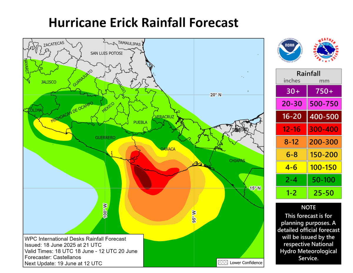
June 18: Major Hurricane #Erick is headed for the coast of Mexico. Erick is expected to bring destructive winds, life-threatening flooding and mudslides to portions of Southern Mexico. For the latest information visit hurricanes.gov

June 18: Major Hurricane #Erick is headed for the coast of Mexico. Erick is expected to bring destructive winds,  life-threatening flooding and mudslides to portions of Southern Mexico. For the latest information visit hurricanes.gov
D Wise (@dwisecinema) 's Twitter Profile Photo

Ship 36 experiences a RUD at Massey's during testing prior to Starship Flight 10. Seen in slow motion. Continue to watch live: youtube.com/watch?v=WKwWcl… 📸: NSF - NASASpaceflight.com

SpaceX (@spacex) 's Twitter Profile Photo

On Wednesday, June 18 at approximately 11 p.m. CT, the Starship preparing for the tenth flight test experienced a major anomaly while on a test stand at Starbase. A safety clear area around the site was maintained throughout the operation and all personnel are safe and accounted

Kent Porter (@kentphotos) 's Twitter Profile Photo

The #RidgeFire just outside Lower Lake, Ca., Wednesday evening, burns about one acre. This is in the 2015 #RockyFire burn scar. #kentporterphotography The Press Democrat CAL FIRE LNU

The #RidgeFire just outside Lower Lake, Ca., Wednesday evening, burns about one acre. This is in the 2015 #RockyFire burn scar. #kentporterphotography <a href="/NorthBayNews/">The Press Democrat</a> <a href="/CALFIRELNU/">CAL FIRE LNU</a>
Kent Porter (@kentphotos) 's Twitter Profile Photo

Yet another fire weather watch for the Sacramento Valley this coming weekend. I really don’t need to tell you why, just step out the door and wind slaps you in the face. Expect to go red flag in the next day. Watch Duty
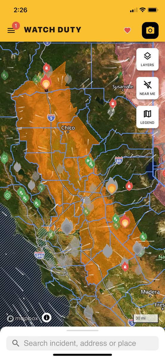
Yet another fire weather watch for the Sacramento Valley this coming weekend. I really don’t need to tell you why, just step out the door and wind slaps you in the face. Expect to go red flag in the next day. <a href="/watchdutyapp/">Watch Duty</a>
Rob Mayeda (@robmayeda) 's Twitter Profile Photo

Going to the source for local fuel moisture content with SJSU Meteorology Wildfire Interdisciplinary Research Center @fireweatherlab How it’s collected and calculated and why it’s an important factor when it comes to fire danger w/ Nick Perlaky 6/16/2025 #CAwx
CAL FIRE LNU (@calfirelnu) 's Twitter Profile Photo

🚩 Red Flag Warning in Effect The NWS Sacramento has announced a RED FLAG WARNING starting today at 11 AM through Sunday at 9 AM (June 21-22, 2025). This Red Flag Warning will be in place for areas below 3,000 ft within the Sacramento Valley including the counties of Colusa,
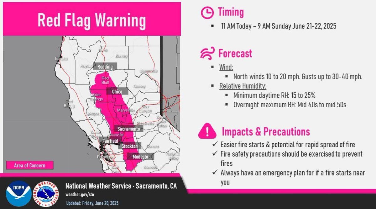
🚩 Red Flag Warning in Effect

The <a href="/NWSSacramento/">NWS Sacramento</a> has announced a RED FLAG WARNING starting today at 11 AM through Sunday at 9 AM (June 21-22, 2025). This Red Flag Warning will be in place for areas below 3,000 ft within the Sacramento Valley including the counties of Colusa,
Kyle Brittain (@badweatherkyle) 's Twitter Profile Photo

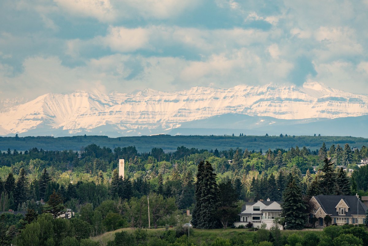
White gold sitting on the peaks southwest of Calgary! One snow measurement site currently has over 83mm of fresh snow water equivalent. #abstorm #yyc

White gold sitting on the peaks southwest of Calgary!

One snow measurement site currently has over 83mm of fresh snow water equivalent. #abstorm #yyc
USCGNorCal (@uscgnorcal) 's Twitter Profile Photo

Press Release update: “Suspending a search is always a difficult decision to make & weighs heavily on each Coast Guard member involved,” said #USCG CDR David Herndon, search and rescue mission coordinator, Coast Guard Sector San Francisco. #LakeTahoe dvidshub.net/news/501193/up…

CAL FIRE LNU (@calfirelnu) 's Twitter Profile Photo

#BenmoreFire: CAL FIRE responded Sunday afternoon to a vegetation fire east of Clearlake Oaks in the vicinity of Old Long Valley Road and Olive Hill Lane. The fire is approximately 1/10 of an acre. It was reported to us from an Artificial Intelligence detection notification at

Con Fire PIO (@contracostafire) 's Twitter Profile Photo

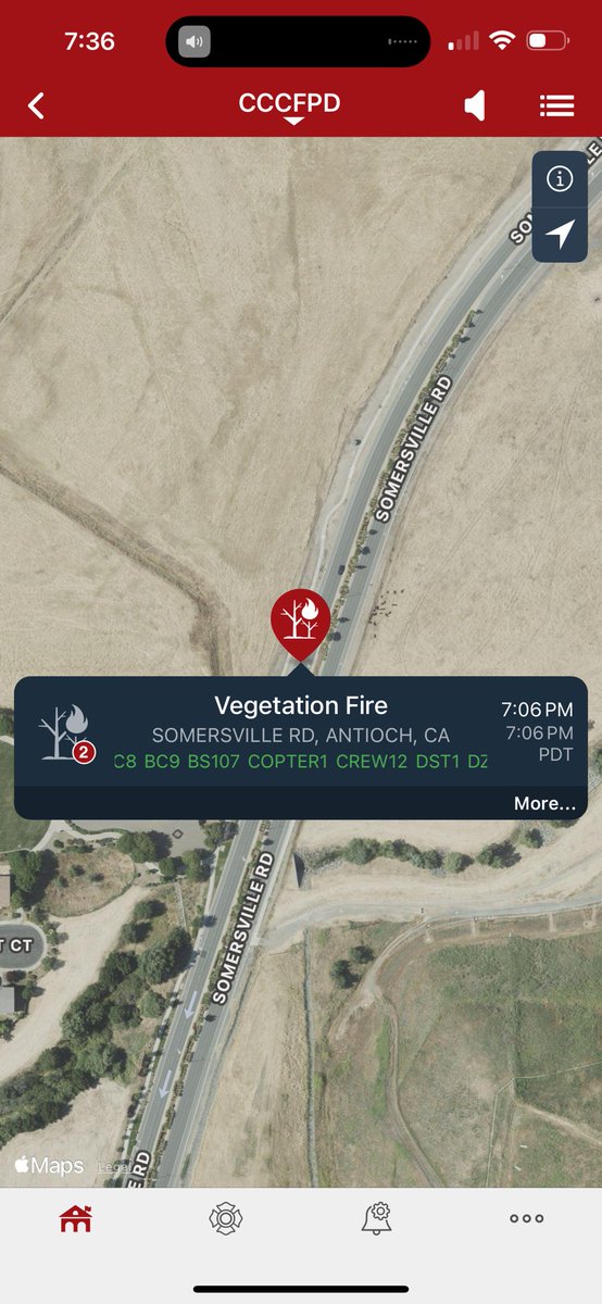
Con Fire is on scene of a vegetation fire in Rodeo with CAL FIRE SCU and Rodeo Hercules. Approx 20 acres. Structure protection is in place. Updates to follow.

Rob Mayeda (@robmayeda) 's Twitter Profile Photo

Upper level haze is mostly still being imported across the US Canada border, while locally higher surface smoke pollution is from fires near Rodeo and Diablo earlier today. Back into Summer mode watching fire.airnow.gov and map.purpleair.com again 6/23/2025

Rob Mayeda (@robmayeda) 's Twitter Profile Photo

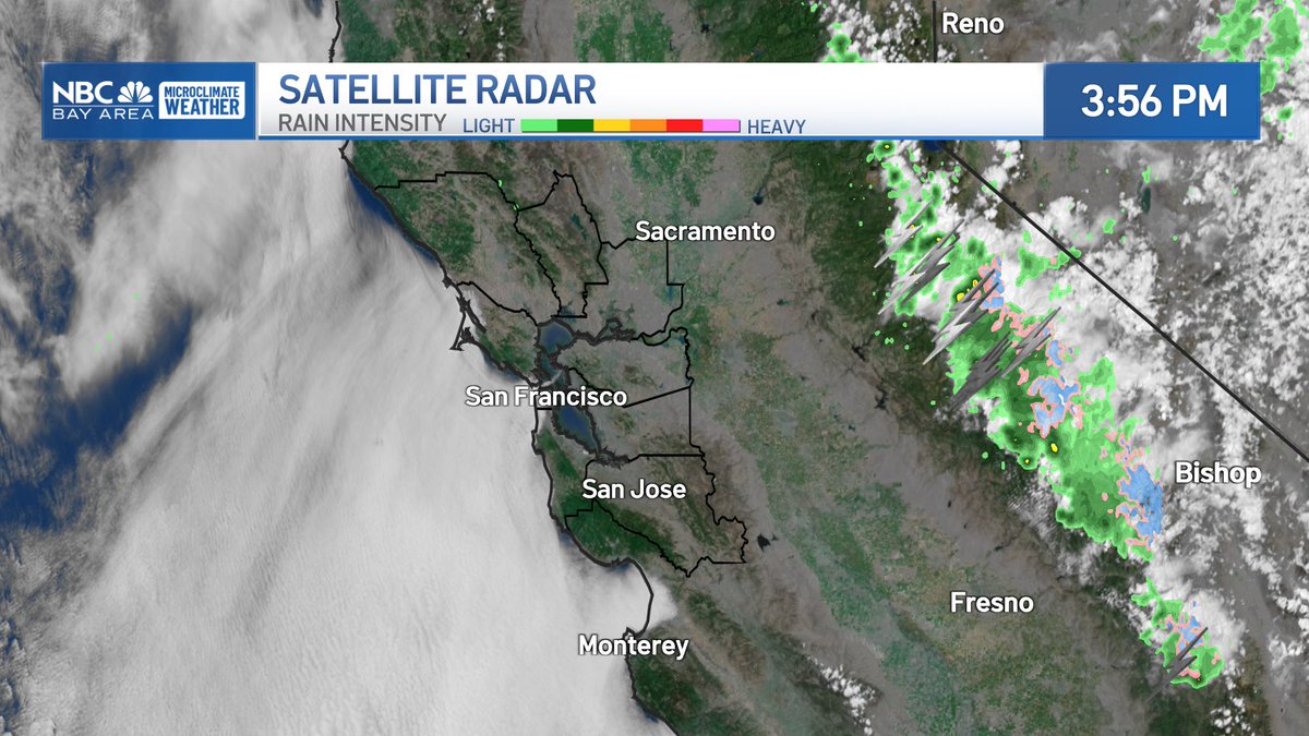
Stable and unstable: the fog footprint is evident on our Bay Area microclimate temperatures today, a classic stable Summer air environment. Meanwhile, it’s quite the opposite near the Sierra, warm moist air rising through cooler air aloft is a recipe for thunderstorms, hail,

Stable and unstable: the fog footprint is evident on our Bay Area microclimate temperatures today, a classic stable Summer air environment. Meanwhile, it’s quite the opposite near the Sierra, warm moist air rising through cooler air aloft is a recipe for thunderstorms, hail,
USGS Volcanoes🌋 (@usgsvolcanoes) 's Twitter Profile Photo

Episode 26 of the ongoing #Kīlauea summit eruption was just under 9 hours long on June 20. You can watch the full episode in this 20-second timelapse video. Episode 26 lava fountains reached approximately 380 meters (1246 feet) just after 3 a.m., a new record for this eruption.