Rob Fowler
@robstormteam2
Official Twitter account of the Chief Meteorologist at WCBD-TV in Charleston, SC. NATAS Silver Circle 2017. Order of the Palmetto 2006. SCBA Masters Award 2025
ID: 16661275
http://www.counton2.com 09-10-2008 03:08:18
53,53K Tweet
13,13K Followers
1,1K Following

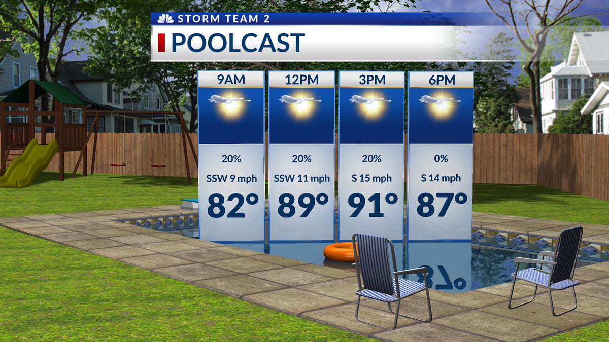
Rob Fowler Storm Team 2 WCBD News 2 | Count on 2 Rob is there a place (website/app) where a normal person can access that hourly data you are sharing in your post? There is way more information there than is in your weather app. It would be very helpful for planning an upcoming trip.


As of 8pm, the strongest storms are moving over Downtown Charleston, James Island, Folly Beach, and Mt. Pleasant. These storms should be entering the ocean in the 30 minutes to an hour. #scwx @stormteam2WCBD WCBD News 2 | Count on 2

As of 8:45pm Friday, July 11th, all severe thunderstorm warnings have expired or been canceled. Rainfall rates have come way down as well, and that will help waters recede and drain where we did see flooding this evening. Storm Team 2 WCBD News 2 | Count on 2

Yesterday evening in Garden City Beach, SC. Jim Cantore America’s Morning Headquarters @bobvandillen The Weather Channel Jen Carfagno The Weather Channel The National Weather Desk Ed Piotrowski Jamie Arnold WMBF @BillWalshTV Rob Fowler Dave Williams Andrew Dockery WeatherNation @foxweatherdesk AccuWeather Video Team Brad Panovich #scwx

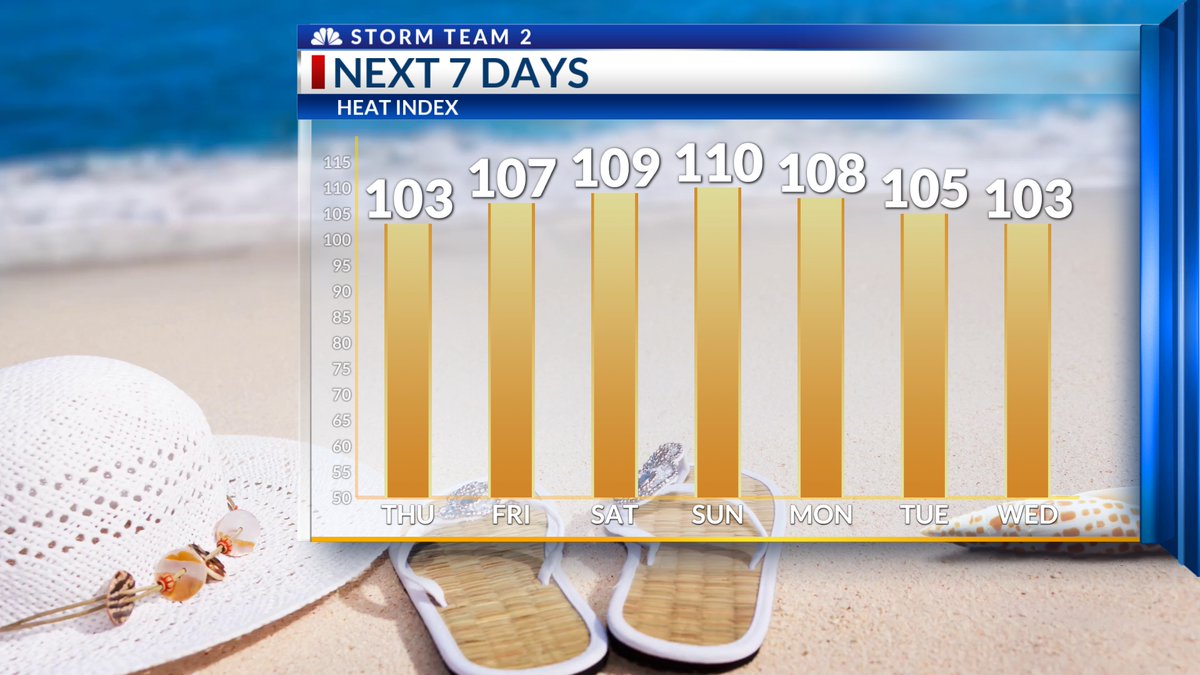
Sunday (7-13) One Stop Shop Forecast! We hit 93 on Sat., and it looks like today promises a bit higher temps this afternoon. Heat Index will peak close to 105. The showers and t-storms should begin popping again later this afternoon. Stay cool and hydrated! Storm Team 2 WCBD News 2 | Count on 2


Great time talking weather at the Divine Redeemer Summer Camp! What a fantastic group!!! Storm Team 2 WCBD News 2 | Count on 2

Thanks to Mark Lynch for thinking of me and sending along this photo from Wexford, Ireland!!! He says the weather there has been unbelievable! Lots of sunshine! Storm Team 2 WCBD News 2 | Count on 2


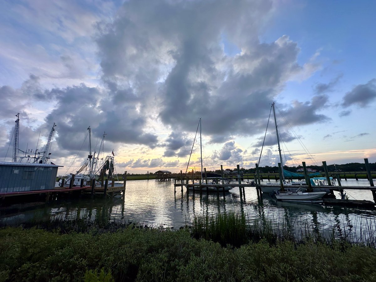
This evening in Murrells Inlet, SC at HBSP. @SC_state_parks Jim Cantore America’s Morning Headquarters @bobvandillen The Weather Channel Jen Carfagno The Weather Channel The National Weather Desk Ed Piotrowski Jamie Arnold WMBF @BillWalshTV Rob Fowler Dave Williams Andrew Dockery WeatherNation @foxweatherdesk AccuWeather Video Team #scwx

Beautiful sunset this evening from Folly Beach, SC. Photos taken by me! #scwx #chswx #follybeach #sunset Rob Fowler Bill Walsh Dave Williams James Spann Ed Piotrowski Cathy Kelley Jim O'Neil


Yesterday evening in Murrells Inlet, SC at HBSP. @SC_state_parks Jim Cantore America’s Morning Headquarters @bobvandillen The Weather Channel Jen Carfagno The Weather Channel The National Weather Desk Ed Piotrowski Jamie Arnold WMBF @BillWalshTV Rob Fowler Dave Williams Andrew Dockery WeatherNation @foxweatherdesk AccuWeather Video Team

WCBD+ is ready for Download!!! WCBD News 2 | Count on 2 Storm Team 2


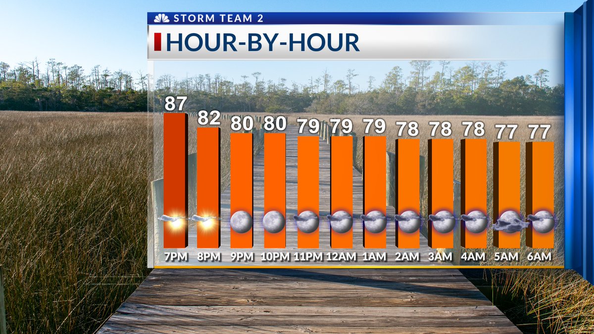
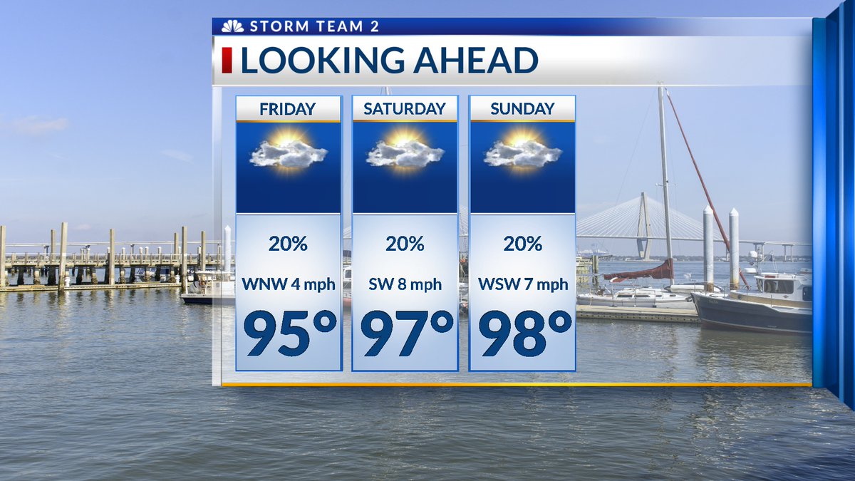
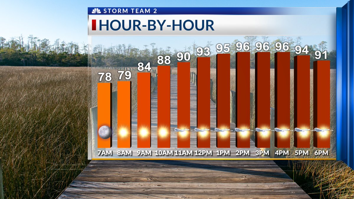
Here is our Saturday (7-19) One Stop Shop Hour by Hour Forecast. Highs in the upper 90’s this afternoon, with a heat index between 105-110. Heat Advisory is in effect from 11am until 8pm today. Storm Team 2 WCBD News 2 | Count on 2

