Robert Ray (@robertraywx) 's Twitter Profile
Robert Ray

@robertraywx

Wanted to be a pro-athlete, that totally didn’t work out..Decided on journalism instead…Fox Weather National Correspondent…Atlanta based…Husker for life…

ID: 315596243

linkhttp://www.foxweather.com calendar_today12-06-2011 04:08:20

11,11K Tweet

3,3K Followers

1,1K Following

FOX Weather (@foxweather) 's Twitter Profile Photo

HISTORIC LODGE GONE: National Park officials say preliminary assessments indicate 50–80 structures have been lost, including the Grand Canyon Lodge. foxweather.com/weather-news/d…

FOX Weather (@foxweather) 's Twitter Profile Photo

⛈️SWAMPED: It's hot and humid in Florida, as a slow-moving system filled with tropical moisture moves over the Sunshine State. A flood threat has been posted for central and south Florida today. Robert Ray is live in Orlando with the latest.

Weather Voyager (@weathervoyage) 's Twitter Profile Photo

The ensembles not picking up on it does give me pause, but this is one part of the basin where models have whiffed big on developing systems. Gordon 2018, Hanna 2020, Sally 2020 all recent examples of notable landfalls that weren’t really sniffed out. Even Chantal this year

Steve Bender (@weatherbender_) 's Twitter Profile Photo

System off the coast of Florida has been designated Invest 93L This allows the National Hurricane Center to run specialized models on the system to try and get a better idea of what will do Hurricane Hunters flying in tomorrow afternoon #FoxWeather
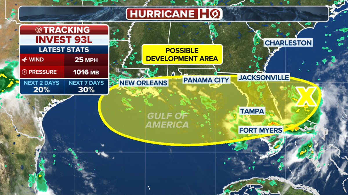
System off the coast of Florida has been designated Invest 93L
 
This allows the <a href="/NHC_Atlantic/">National Hurricane Center</a>  to run specialized models on the system to try and get a better idea of what will do

<a href="/53rdWRS/">Hurricane Hunters</a> flying in tomorrow afternoon

#FoxWeather
National Hurricane Center (@nhc_atlantic) 's Twitter Profile Photo

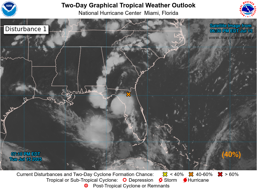
8pm EDT July 14: An area of low pressure off the east Florida Peninsula coast (Invest #93L) now has a medium chance (30%🟡2-day / 40%🟠7-day) of becoming a tropical cyclone as it moves westward into northeastern portion of the Gulf. Regardless of formation, heavy rainfall could

8pm EDT July 14: An area of low pressure off the east Florida Peninsula coast (Invest #93L) now has a medium chance (30%🟡2-day / 40%🟠7-day) of becoming a tropical cyclone as it moves westward into northeastern portion of the Gulf.

Regardless of formation, heavy rainfall could
Weather Voyager (@weathervoyage) 's Twitter Profile Photo

MLC pretty clear on radar east of Cape Canaveral. Overnight convection will strengthen this vortex before moving inland tomorrow. This MLC needs to remain potent when it emerges over the Gulf if this is going to be a more than a low end TC there

FOX Weather (@foxweather) 's Twitter Profile Photo

🌀 HURRICANE HQ: The Gulf Coast is bracing for a potential tropical storm as Invest 93L shows increasing signs of developing into Dexter, with landfall possible as early as this week, the FOX Forecast Center warns. foxweather.com/weather-news/i…

National Hurricane Center (@nhc_atlantic) 's Twitter Profile Photo

8pm 7/15: A low pressure area (Invest #93L) could emerge over the far northeastern & north-central Gulf, approaching Louisiana on Thursday as it moves westward. Environmental conditions over the Gulf are generally favorable, and a tropical depression could form if the system

8pm 7/15: A low pressure area (Invest #93L) could emerge over the far northeastern &amp; north-central Gulf, approaching Louisiana on Thursday as it moves westward. Environmental conditions over the Gulf are generally favorable, and a tropical depression could form if the system
Robert Ray (@robertraywx) 's Twitter Profile Photo

Behind-the-Scenes: Nice working with DP Mike Ladisa here in Orlando; thanks for the pics of your awesome assembly and the strong live shots through your lens. Technical meets creative equals winning in the TV biz, and having both is not hugely common across the industry. I

Behind-the-Scenes: Nice working with DP Mike Ladisa here in Orlando; thanks for the pics of your awesome assembly and the strong live shots through your lens. Technical meets creative equals winning in the TV biz, and having both is not hugely common across the industry. I
FOX Weather (@foxweather) 's Twitter Profile Photo

After producing storms throughout parts of Florida, Invest 93L has made its way across the Sunshine State's peninsula and into the northern Gulf Coast. FOX Weather Correspondent Robert Ray breaks it all down from Orlando, Florida.

National Hurricane Center (@nhc_atlantic) 's Twitter Profile Photo

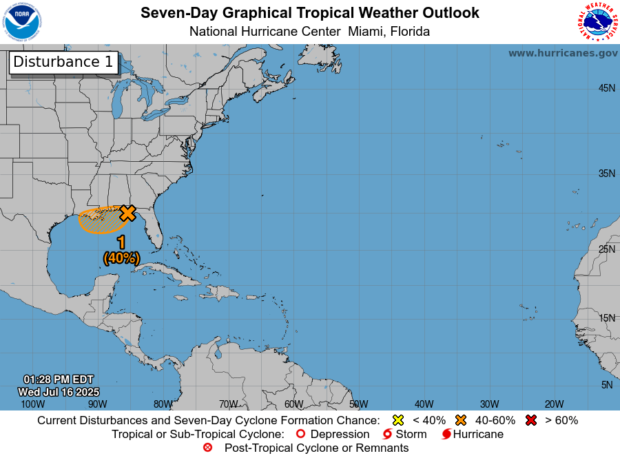
2pm 7/16: A low pressure area (Invest #93L) located near the coast of the Florida Panhandle is forecast to move westward to near the southeast coast of Louisiana on Thursday. Environmental conditions are generally favorable for some development, and a tropical depression could

2pm 7/16: A low pressure area (Invest #93L) located near the coast of the Florida Panhandle is forecast to move westward to near the southeast coast of Louisiana on Thursday. Environmental conditions are generally favorable for some development, and a tropical depression could
FOX Weather (@foxweather) 's Twitter Profile Photo

While Invest 93L has almost no chance of any further tropical development, flood threats persist for the Gulf Coast. FOX Weather Correspondent Robert Ray reports from New Orleans on what to expect:

FOX Weather (@foxweather) 's Twitter Profile Photo

FOX Weather Correspondent Robert Ray reports from New Orleans today with the latest updates as Invest 93L could bring a potential flood threat to Louisiana. #Louisiana #neworleans #rain #flood #SevereWx #FoxWeather

FOX Weather (@foxweather) 's Twitter Profile Photo

FOX Weather Correspondent Robert Ray reports from New Orleans ahead of some potentially nasty weather, as Invest 93L looks to drench parts of Louisiana. #Louisiana #neworleans #SevereWx #rain #flood #FoxWeather

National Hurricane Center (@nhc_atlantic) 's Twitter Profile Photo

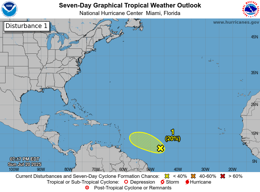
8pm EDT 20 July: NHC is watching a small area of low pressure (Invest #94L) in the Central Tropical Atlantic. This system has a low chance (20% 🟡) of becoming a tropical cyclone before moving into less favorable environmental conditions. Latest outlook: hurricanes.gov/gtwo.php?basin…

8pm EDT 20 July: NHC is watching a small area of low pressure (Invest #94L) in the Central Tropical Atlantic. This system has a low chance (20% 🟡) of becoming a tropical cyclone before moving into less favorable environmental conditions.

Latest outlook: hurricanes.gov/gtwo.php?basin…
FOX Weather (@foxweather) 's Twitter Profile Photo

😢HISTORY DESTROYED: New photos show the destruction left after the Dragon Bravo wildfire tore through the North Rim of Grand Canyon National Park. foxweather.com/earth-space/gr…

😢HISTORY DESTROYED: New photos show the destruction left after the Dragon Bravo wildfire tore through the North Rim of Grand Canyon National Park.  foxweather.com/earth-space/gr…
FOX Weather (@foxweather) 's Twitter Profile Photo

🥵 EXTREME HEAT: FOX Weather is tracking an extreme heat dome that will bring life-threatening temperatures to millions across the U.S. Fans attending the Cubs game in Chicago will face brutal temps today. Robert Ray reports from Wrigley Field. foxweather.com/weather-news/h…