®RuithaFelix
@ruizlex_0
Geospatial Engineer, Remote Sensing & GIS Expert.
Engineering Surveys, Cadastral Survey, Topographical Mapping , Mutation, Control Surveys e.t.c.
ID: 892974328320581632
03-08-2017 05:04:05
1,1K Tweet
3,3K Followers
2,2K Following
 's Twitter Profile Photo")
 on Twitter photo 🔥The 9th Round of Easy Loan, Earn $40 Reward is in progress❗️
⏰ Promotion Period: January 15th - Feburary 15th, 2025
👉 Register now and check more details at gate.io/campaigns/358")
 's Twitter Profile Photo")
 's Twitter Profile Photo")
 on Twitter photo 🙁😏😒😌🤤🤗
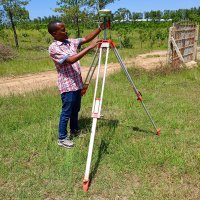
We own one now.
It's been God from day one.
Let's enjoy the surveying profession.")
 on Twitter photo Engineering Survey.")
 's Twitter Profile Photo")
 on Twitter photo 25/30
Design")
 's Twitter Profile Photo")
 on Twitter photo Every Kikuyus Dream yawa..
Looks good 😊")
 on Twitter photo My Buddies, do you do Engineering Surveys using GNSS?🤔
.. how do you maintain the Accuracy? 🤪😜😜")
 on Twitter photo ❤️🔥Engineering is Broad, accommodating everyone with the passion 😀😁....
#landsurvey
#Engineering
#geography")
 on Twitter photo Site opening 🙂")
 on Twitter photo Sectioning the sectionals😀😁🤤.....
Sectional Property 🤗")
 's Twitter Profile Photo")
 on Twitter photo 29 FREE GIS PROGRAMMING TUTORIALS
🧵")
 on Twitter photo Engineering at the peak🤗")
 's Twitter Profile Photo")
 on Twitter photo What's your taste and preference?
Flat roof or pitched roof.")
 on Twitter photo Some good stuffs.. great deal here 🤗")
 on Twitter photo Tanzania has the Mountain, Kenya we have the view🤗😀😀😀.. GNSS near Border....😁")
 on Twitter photo Mountain View🙂.... Subdivision at Kimana🤗")
 's Twitter Profile Photo")
 on Twitter photo BREAKING: KNH Makes History with World’s First Transhumeral TSR Surgery
We have performed the World’s First Transhumeral Targeted Sensory Reinnervation (TSR) surgery on Moses Mwendwa, 22, restoring sensation in his missing left hand! This groundbreaking 7-hour procedure reroutes")
 on Twitter photo When work is well done🤗")
 on Twitter photo Special for my good friends🤣🤣🤣💔")
 's Twitter Profile Photo")
 on Twitter photo I have a qn; while using RTK normally I pick points using either wgs84 OR Arc1960, when exporting to google earth they don't exactly check with how the boundaries appear on google earth, their is slight difference of around 100m.")
 on Twitter photo Some Surveyors don't remember what \"BM\" stands for 😅😅🤪💔..")