Spatial Analysis Lab - University of Montana (@sal_umontana) 's Twitter Profile
Spatial Analysis Lab - University of Montana

@sal_umontana

-Landscape-scale ecological information -Partnerships with agency personnel, research groups. #lidar #remotesensing #vegetation #spatialanalytics @umontana

ID: 1170946633829253121

linkhttp://www.umt.edu/spatial-analysis-lab/ calendar_today09-09-2019 06:26:58

806 Tweet

536 Followers

460 Following
🇧🇿 Belize GEO 🛰️ (@bzgeo) 's Twitter Profile Photo

FWIW, the *free* Cloud-Based Remote Sensing with Google Earth Engine: Fundamentals and Applications (EEFA) book [edited by Drs. Jeff Cardille, @morganahcrowley David Saah Nick Clinton] provides excellent resources: eefabook.org. EEFAbook

FWIW, the *free* Cloud-Based Remote Sensing with Google Earth Engine: Fundamentals and Applications (EEFA) book [edited by Drs. <a href="/jcardille/">Jeff Cardille</a>, @morganahcrowley <a href="/dsaah/">David Saah</a> Nick Clinton] provides excellent resources: eefabook.org. <a href="/EEFAbook/">EEFAbook</a>
Bette Loiselle (@betteloiselle) 's Twitter Profile Photo

Excited to announce the Asst Prof position in Landscape Ecology at Univ. Florida! Learn more here: University of Florida - Details - Assistant or Associate Professor - Wildlife Landscape Ecologist– Wildlife Ecology and Conservation #GoGators UF IFAS Wildlife UF SNRE

Di Yang 杨荻 (@yangdi1031) 's Twitter Profile Photo

🌳 Excited to announce I'm guest editing a new Special Feature on "Technological Advances in Forest Monitoring and Management"! If you're working on innovative approaches using #RS, #GIS, robotics, or AI for forest monitoring, we'd love to see your work.nature.com/collections/hf…

Di Yang 杨荻 (@yangdi1031) 's Twitter Profile Photo

Back from an incredible Global Land Programme (GLP) meeting! The rich cultural heritage of Oaxaca provided the perfect backdrop for engaging discussions about sustainable land management. Excited to implement new ideas and collaborations from this experience! 🌎🇲🇽 #GLP2024

Back from an incredible Global Land Programme (GLP) meeting! The rich cultural heritage of Oaxaca provided the perfect backdrop for engaging discussions about sustainable land management. Excited to implement new ideas and collaborations from this experience! 🌎🇲🇽 #GLP2024
NCEAS (@ucsb_nceas) 's Twitter Profile Photo

Proposals are now open through the Gulf Ecosystem Initiative to fund 2-3 working groups to travel to Santa Barbara, CA 2-4 times over 24 months to develop science for decision making in the Gulf of Mexico. Apply here by March 14th, 2025: nceas.ucsb.edu/gulfeco

Proposals are now open through the Gulf Ecosystem Initiative to fund 2-3 working groups to travel to Santa Barbara, CA 2-4 times over 24 months to develop science for decision making in the Gulf of Mexico. Apply here by March 14th, 2025: nceas.ucsb.edu/gulfeco
Qiusheng Wu (@giswqs) 's Twitter Profile Photo

🚨 Exciting news! OpenStreetMap now hosts vector tiles on OSMF hardware! 🎉 Want to learn how to use OSM vector tiles with Leafmap and MapLibre? Check this out: 👉 Demo: maps.gishub.org/maplibre/opens… 👉 Notebook: leafmap.org/maplibre/opens… For more information about the OSM vector

🚨 Exciting news! OpenStreetMap now hosts vector tiles on OSMF hardware! 🎉

Want to learn how to use OSM vector tiles with Leafmap and MapLibre? Check this out:

👉 Demo: maps.gishub.org/maplibre/opens…
👉 Notebook: leafmap.org/maplibre/opens…

For more information about the OSM vector
Ujaval Gandhi (@spatialthoughts) 's Twitter Profile Photo

Super excited to launch our flagship course End-to-End Google #EarthEngine on YouTube! Completely free for self-study and with no ads. Get started now at youtube.com/watch?v=jGuCnu…

Super excited to launch our flagship course End-to-End Google #EarthEngine on YouTube! Completely free for self-study and with no ads. Get started now at youtube.com/watch?v=jGuCnu…
Land-Cover & Land-Use Change (LCLUC) Program (@lclucprogram) 's Twitter Profile Photo

Discover how deep learning and high-resolution aerial imagery are transforming energy land use detection in the Permian Basin! Join Dr. Xiao-Peng Song [Univ. of Maryland] for this exciting webinar. Register now! 👇lp.constantcontactpages.com/ev/reg/35p2983…

Discover how deep learning and high-resolution aerial imagery are transforming energy land use detection in the Permian Basin! Join Dr. Xiao-Peng Song [Univ. of Maryland] for this exciting webinar. Register now! 👇lp.constantcontactpages.com/ev/reg/35p2983…
Di Yang 杨荻 (@yangdi1031) 's Twitter Profile Photo

Our new research combines NEON field measurements with geospatial analysis to map standing dead tree clusters in Yellowstone National Park, providing park managers with a data-driven framework for prioritizing wildfire vulnerability zones. #NEON #GIScience NEON

Our new research combines NEON field measurements with geospatial analysis to map standing dead tree clusters in Yellowstone National Park, providing park managers with a data-driven framework for prioritizing wildfire vulnerability zones. #NEON #GIScience <a href="/NEON_sci/">NEON</a>
Africa Flores (@africa_science) 's Twitter Profile Photo

Submit your abstract to #IGARSSS25 Synergistic Applications of VSWIR Hyperspectral and Thermal Infrared Data in Support of Future Earth Science Satellite Missions earthdata.nasa.gov/events/synergi…

Google.org (@googleorg) 's Twitter Profile Photo

📢 Calling all orgs using genAI for social impact! Apply to the Google.org Accelerator: Generative AI for an opportunity to receive a share of $30M in funding, access to product credits, training, and expert support for your solutions. g.co/Accelerator/ge…

Keiko (@keiko_geo) 's Twitter Profile Photo

Landsat 8 and 9 captured images of areas affected by wildfires, a day before and after (during) the events. The image from January 14th shows the ongoing fires around the perimeters of the Palisades and Altadena fires. ee-nkeikon.projects.earthengine.app/view/la-fire-b…

Landsat 8 and 9 captured images of areas affected by wildfires, a day before and after (during) the events. The image from January 14th shows the ongoing fires around the perimeters of the Palisades and Altadena fires.
ee-nkeikon.projects.earthengine.app/view/la-fire-b…
Qiusheng Wu (@giswqs) 's Twitter Profile Photo

🚀 Just dropped a new tutorial: Learn how to build a Local AI like ChatGPT using Deepseek R1 and Open WebUI! 🖥️ Enjoy complete control over your local AI while keeping your data private and secure. 🔥 DeepSeek-R1 is a new free and open-source LLM that achieves performance

🚀 Just dropped a new tutorial: Learn how to build a Local AI like ChatGPT using Deepseek R1 and Open WebUI! 🖥️ Enjoy complete control over your local AI while keeping your data private and secure.

🔥 DeepSeek-R1 is a new free and open-source LLM that achieves performance
NASA DEVELOP (@nasa_develop) 's Twitter Profile Photo

🗺️ Last Thursday was the DEVELOP Day of Service, and our spring 2025 participants celebrated with another mini mapathon! 82 DEVELOPers digitized more than 9,200 buildings in areas of humanitarian need for the Missing Maps project. Thank you to all who contributed!

🗺️ Last Thursday was the DEVELOP Day of Service, and our spring 2025 participants celebrated with another mini mapathon! 82 DEVELOPers digitized more than 9,200 buildings in areas of humanitarian need for the Missing Maps project. Thank you to all who contributed!
Jeffery B. Cannon, PhD🌲🔥🌪️ (@jefferybcannon) 's Twitter Profile Photo

Please RT and share! JOIN THE LAB! We are looking to recruit a motivated PhD student to study how fire shapes forest dynamics in #longleaf pine at the beautiful The Jones Center at Ichauway with Dr. Heather Alexander at Auburn University. Apps due Feb 28, 2025. jonesctr.org/wp-content/upl…

Please RT and share! JOIN THE LAB! We are looking to recruit a motivated PhD student to study how fire shapes forest dynamics in #longleaf pine at the beautiful <a href="/thejonesctr/">The Jones Center at Ichauway</a> with Dr. Heather Alexander at Auburn University. Apps due Feb 28, 2025. jonesctr.org/wp-content/upl…
Daijiang Li (@_djli) 's Twitter Profile Photo

In Nature Climate Change NatureClimate, we show that Extreme Weather Events (EWEs) have strong but different effects on plant and insect phenology. nature.com/articles/s4155… rdcu.be/eaLMu

Di Yang 杨荻 (@yangdi1031) 's Twitter Profile Photo

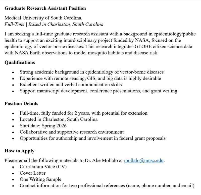
Now Hiring: Graduate Research Assistant Join the team at the Medical University of South Carolina for a fully funded, full-time position starting Spring 2026! #citizenscience #gis #NASAScience

Now Hiring: Graduate Research Assistant
Join the team at the Medical University of South Carolina for a fully funded, full-time position starting Spring 2026! #citizenscience #gis #NASAScience
Di Yang 杨荻 (@yangdi1031) 's Twitter Profile Photo

Thrilled to share that our team won a poster award at CAPS 2025! Was an incredible conference celebrating how communities are transforming science through citizen participation- the energy and innovation on display was absolutely inspiring #citizenscience #CommunityScience #GLOBE

Thrilled to share that our team won a poster award at CAPS 2025! Was an incredible conference celebrating how communities are transforming science through citizen participation- the energy and innovation on display was absolutely inspiring #citizenscience #CommunityScience #GLOBE