Shi Qiu (@shi60604194) 's Twitter Profile
Shi Qiu

@shi60604194

Assistant Research Professor, Global Environmental Remote Sensing (GERS) Laboratory, University of Connecticut

ID: 995386450941276160

linkhttps://sites.google.com/view/sqiu calendar_today12-05-2018 19:33:18

35 Tweet

99 Followers

118 Following
Zhe Zhu πŸŒŽπŸ›°οΈ (@gerslab) 's Twitter Profile Photo

Interested in how the various cloud and cloud shadow detection algorithms work for Sentinel-2 data? Check this Preprint submitted to Science of Remote Sensing, "Comparison of Cloud Detection Algorithms for Sentinel-2 Imagery" at doi.org/10.1016/j.srs.…

Interested in how the various cloud and cloud shadow detection algorithms work for Sentinel-2 data? Check this Preprint submitted to Science of Remote Sensing, "Comparison of Cloud Detection Algorithms for Sentinel-2 Imagery" at doi.org/10.1016/j.srs.…
UConn Research (@uconnresearch) 's Twitter Profile Photo

.UConn researchers are partnering with international geo-imaging software company CATALYST to democratize access to powerful remote sensing and geospatial data. today.uconn.edu/2021/02/new-ce… CATALYST.Earth Zhe Zhu πŸŒŽπŸ›°οΈ @UConnNRE

Zhe Zhu πŸŒŽπŸ›°οΈ (@gerslab) 's Twitter Profile Photo

New opportunity in GERS Lab this fall! This is a fully-funded research assistant position at MS or Ph.D. level that will work on mapping understory invasive species based on satellite time series. A retweet is very much appreciated! gerslab.uconn.edu/wp-content/upl… #timeseries #understory

Zhe Zhu πŸŒŽπŸ›°οΈ (@gerslab) 's Twitter Profile Photo

New SRS paper from Qiu et al (2021) Shi Qiu. The Landsat 7's orbit is drifting to an earlier acquisition time since 2017. Can Landsat 7 still preserve its science capability with a drifting orbit? We not only provided an answer but also a solution. doi.org/10.1016/j.srs.…

Zhe Zhu πŸŒŽπŸ›°οΈ (@gerslab) 's Twitter Profile Photo

If you are still using Landsat 7 data collected after 2020, you may in trouble due to its orbit drift that was started in 2017. Check this new study from Science of Remote Sensing for details. A retweet is greatly appreciated. #Landsat #orbit doi.org/10.1016/j.srs.…

If you are still using Landsat 7 data collected after 2020, you may in trouble due to its orbit drift that was started in 2017. Check this new study from Science of Remote Sensing for details. A retweet is greatly appreciated. #Landsat #orbit doi.org/10.1016/j.srs.…
Zhe Zhu πŸŒŽπŸ›°οΈ (@gerslab) 's Twitter Profile Photo

How is land change viewed through the lens of remote sensing? What are the differences among spectral change, disturbance, cover modification/conversion/change, surface change? A new multifaceted perspective for this. Please RT and comment on the preprint. essoar.org/doi/abs/10.100…

Zhe Zhu πŸŒŽπŸ›°οΈ (@gerslab) 's Twitter Profile Photo

Remote sensing detects land change based on the spectral change cube, and this cube can be flattened and converted to land change information which is usually a multifaceted issue.

Remote sensing detects land change based on the spectral change cube, and this cube can be flattened and converted to land change information which is usually a multifaceted issue.
USGS Landsat (@usgslandsat) 's Twitter Profile Photo

After much anticipation, USGS Landsat 9 products are now available! Download data via EarthExplorer, M2M, and LandsatLook. πŸ•« Read the full tech release at ow.ly/vsFM50HRYkE Landsat is a joint mission of the USGS and NASA Landsat [🧡1/4]

After much anticipation, <a href="/USGS/">USGS</a> Landsat 9 products are now available! Download data via EarthExplorer, M2M, and LandsatLook. 

πŸ•« Read the full tech release at ow.ly/vsFM50HRYkE

Landsat is a joint mission of the <a href="/USGS/">USGS</a> and <a href="/NASA_Landsat/">NASA Landsat</a> [🧡1/4]
Zhe Zhu πŸŒŽπŸ›°οΈ (@gerslab) 's Twitter Profile Photo

The NE US coastal tidal wetlands are changing fast due to sea-level rise, natural hazards, and human activities. However, analyzing their change is difficult due to tidal fluctuation (very noisy time series!). DECODE is our first attempt. Please help RT. sciencedirect.com/science/articl…

The NE US coastal tidal wetlands are changing fast due to sea-level rise, natural hazards, and human activities. However, analyzing their change is difficult due to tidal fluctuation (very noisy time series!). DECODE is our first attempt. Please help RT. sciencedirect.com/science/articl…
Zhe Zhu πŸŒŽπŸ›°οΈ (@gerslab) 's Twitter Profile Photo

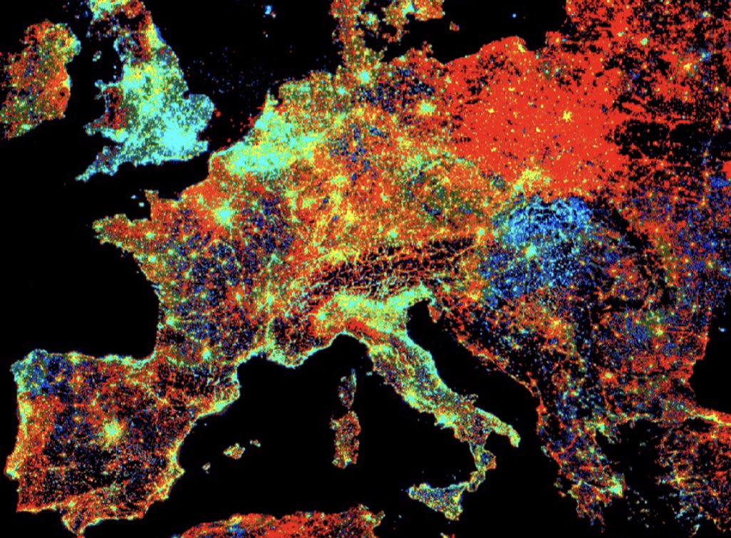
We developed the first algorithm that uses daily nighttime light data from NASA Balck Marble Product @DrMiguelRoman for accurate continuous monitoring of global nighttime light change. Global products will be released by NASA soon. Please help RT. sciencedirect.com/science/articl…

We developed the first algorithm that uses daily nighttime light data from NASA Balck Marble Product @DrMiguelRoman for accurate continuous monitoring of global nighttime light change. Global products will be released by NASA soon. Please help RT. 
sciencedirect.com/science/articl…
Zhe Zhu πŸŒŽπŸ›°οΈ (@gerslab) 's Twitter Profile Photo

πŸ“°The first review for synopsizing the detection and characterization of land change as a five-facet task in a systematic manner. Be careful of the multifaceted nature of land change, as it can be confusing. Please RT! #OpenAccess #Review #LandChange 1/n sciencedirect.com/science/articl…
Mike Wulder (@mikewulder) 's Twitter Profile Photo

The #GEE resource you have been waiting for! #GoogleEarthEngine Cardille et al. 2022. Cloud-Based Remote Sensing with Google Earth Engine: Fundamentals and Applications. >100 authors (well done all!) >55 chapters, labs, >10,000 lines of code #OpenAccess: eefabook.org

The #GEE resource you have been waiting for! #GoogleEarthEngine

Cardille et al. 2022. Cloud-Based Remote Sensing with Google Earth Engine: Fundamentals and Applications.

&gt;100 authors (well done all!)
&gt;55 chapters, labs, &gt;10,000 lines of code
#OpenAccess:
eefabook.org
Zhe Zhu πŸŒŽπŸ›°οΈ (@gerslab) 's Twitter Profile Photo

A fully funded Master's or Ph.D. position is available at GERS Lab working on an exciting NASA-funded project using Landsat and ECOSTRESS time series for studying water-use and land-cover change. Please submit your CV, transcript, & research statement to [email protected] Please RT

Zhe Zhu πŸŒŽπŸ›°οΈ (@gerslab) 's Twitter Profile Photo

With so many image compositing algorithms available, have you ever wondered which one works better? The short answer is that it depends on many factors. For different applications and compositing periods, different algorithm excels. Please RT! authors.elsevier.com/a/1gCap7qzSxcL…

Mike Wulder (@mikewulder) 's Twitter Profile Photo

πŸ“’ Qiu et al. Evaluation of #Landsat image compositing algorithms. Shi Qiu -10 pixel composting algorithms considered. Assessed with reference to temporal representation as well as spatial, spectral, and applications considerations. #LTSBAP #landcover sciencedirect.com/science/articl…

πŸ“’ Qiu et al. Evaluation of #Landsat image compositing algorithms. <a href="/Shi60604194/">Shi Qiu</a>
-10 pixel composting algorithms considered. Assessed with reference to temporal representation as well as spatial, spectral, and applications considerations. #LTSBAP #landcover
sciencedirect.com/science/articl…
UConn CAHNR (@uconncahnr) 's Twitter Profile Photo

With a new algorithm for image compositing, as well as a framework for evaluating all other approaches, CAHNR researchers Zhe Zhu and Shi Qiu are improving accuracy of land change imagery. today.uconn.edu/2023/02/cleari… UConn ResearchΒ Zhe Zhu πŸŒŽπŸ›°οΈΒ @UConnNRE

Zhe Zhu πŸŒŽπŸ›°οΈ (@gerslab) 's Twitter Profile Photo

πŸ“°Can multispectral remote sensing data map vegetation species? Can they map understory? What about mapping understory species? The answer is yes and only possible with dense time series. Great work led by Xiucheng Yang and Shi Qiu. Please RT! authors.elsevier.com/c/1h0lf7qzS-Pg…

Zhe Zhu πŸŒŽπŸ›°οΈ (@gerslab) 's Twitter Profile Photo

The GERS Laboratory is hiring a Postdoctoral Researcher to develop new methods for mapping global construction changes based on multi-sensor time series observations and artificial intelligence. Please send your CV to [email protected] if you are interested ASAP. Please RT!

The GERS Laboratory is hiring a Postdoctoral Researcher to develop new methods for mapping global construction changes based on multi-sensor time series observations and artificial intelligence. Please send your CV to zhe@uconn.edu if you are interested ASAP.

Please RT!
Zhe Zhu πŸŒŽπŸ›°οΈ (@gerslab) 's Twitter Profile Photo

DECODER - expanded on the DECODE algorithm for tracking mangrove recovery (where the last letter R comes from) is developed by Xiucheng Yang. Change is never a binary thing, and we gave four mangrove conditions: healthy, disturbed, recover, & decline. authors.elsevier.com/sd/article/S00…

DECODER - expanded on the DECODE algorithm for tracking mangrove recovery (where the last letter R comes from) is developed by <a href="/xiucheng_yang/">Xiucheng Yang</a>. Change is never a binary thing, and we gave four mangrove conditions: healthy, disturbed, recover, &amp; decline.

authors.elsevier.com/sd/article/S00…