Joe Furey (@stormfurey) 's Twitter Profile
Joe Furey

@stormfurey

Co-Chief Meteorologist for ABC AFFILIATE WTNH CH. 8 in
New Haven/Hartford CT. On Air 5/6/11PM on NEWS 8 and WCTX 8/9/10PM

ID: 404851901

linkhttp://wtnh.com calendar_today04-11-2011 14:08:34

13,13K Tweet

7,7K Followers

2,2K Following

Ben Noll (@bennollweather) 's Twitter Profile Photo

Why has there been so many flooding events? Large amounts of water are pulsing through the skies across the United States — in many cases, near-record high levels. This vapor is being funneled along the southern and western flank of the Bermuda high pressure system, streaming

NWS New York NY (@nwsnewyorkny) 's Twitter Profile Photo

GOES-East Infrared Satellite captured a complex of showers/storms early this morning. The brighter colors indicate cold cloud tops, -75F to -95F. These clouds reached above 40 thousand feet in the atmosphere, producing frequent lightning across E LI & SE CT between 1:30-3:00am.

Tornado Talk (@tornado_talk) 's Twitter Profile Photo

Hamden–New Haven, CT F4 #Tornado – July 10, 1989! Part of a major Northeast outbreak, this was one of only two F4 tornadoes on record in Connecticut. It tore through Hamden, destroying 350 homes and 40 businesses. Over 30 streets were blocked by fallen trees. There were 40

Hamden–New Haven, CT F4 #Tornado – July 10, 1989! Part of a major Northeast outbreak, this was one of only two F4 tornadoes on record in Connecticut. It tore through Hamden, destroying 350 homes and 40 businesses. Over 30 streets were blocked by fallen trees. There were 40
Ralphs Weather OBS (@weathernut27) 's Twitter Profile Photo

# of 70°+ Dews June 1 - July 11 2001: 10 2002: 10 2003: 9 2004: 8 2005: 10 2006: 8 2007: 4 2008: 8 2009: 1 2010: 13 2011: 5 2012: 9 2013: 18 2014: 9 2015: 7 2016: 4 2017: 7 2018: 10 2019: 10 2020: 13 2021: 17 2022: 5 2023: 13 2024: 19 2025: 18

# of 70°+ Dews June 1 - July 11

2001:   10
2002:  10
2003:   9
2004:  8
2005:  10
2006:   8
2007:   4
2008:  8
2009:  1
2010:   13
2011:   5
2012:  9
2013:  18
2014:  9
2015:   7
2016:  4
2017:  7
2018:  10
2019:   10
2020:  13
2021:  17
2022:  5
2023: 13
2024: 19
2025: 18
NWS Boston (@nwsboston) 's Twitter Profile Photo

Dangerous heat and humidity will impact our region this week...beginning Tuesday and may persist through Friday. The heat may peak in the Wednesday to Thursday time frame.

IEMBot BOX (@iembot_box) 's Twitter Profile Photo

BOX issues Flood Watch valid at Jul 14, 12:00 PM EDT for Hartford [CT] and Eastern Franklin, Eastern Hampden, Eastern Hampshire, Western Franklin, Western Hampden, Western Hampshire [MA] till Jul 15, 12:00 AM EDT mesonet.agron.iastate.edu/vtec/f/2025-O-…

BOX issues Flood Watch valid at Jul 14, 12:00 PM EDT for Hartford [CT] and Eastern Franklin, Eastern Hampden, Eastern Hampshire, Western Franklin, Western Hampden, Western Hampshire [MA] till Jul 15, 12:00 AM EDT mesonet.agron.iastate.edu/vtec/f/2025-O-…
CBS New York (@cbsnewyork) 's Twitter Profile Photo

Our crews were on the scene in Scotch Plains, New Jersey, where they witnessed a dramatic water rescue unfold. A flash flood warning is still in effect as downpours soak parts of Tri-State Area. cbsloc.al/464J83X

Noah Bergren (@nbergwx) 's Twitter Profile Photo

Well well well. The MLB radar from the Space Coast is looking interesting... sure looks like this tropical invest is trying to organize. It is nearing the Gulf stream which could be aiding. Thunderstorms appear to be trying to wrap around a center point. An official tropical

Oliya Scootercaster 🛴 (@scootercasterny) 's Twitter Profile Photo

First Responders RESCUED people from their flooded cars on the Saw Mill Parkway in Westchester County, NY as Downpours caused traffic havoc. Video by Dakota Santiago (FreedomNews.Tv FNTV) [email protected] to license

jeff aborn (@jcaborn) 's Twitter Profile Photo

Joe Furey Hi Joe man we sure missed all that rain yesterday. I only picked up .10'' here in Staffordville, also my temp made it to 91 degrees here stay cool.....

R A W S A L E R T S (@rawsalerts) 's Twitter Profile Photo

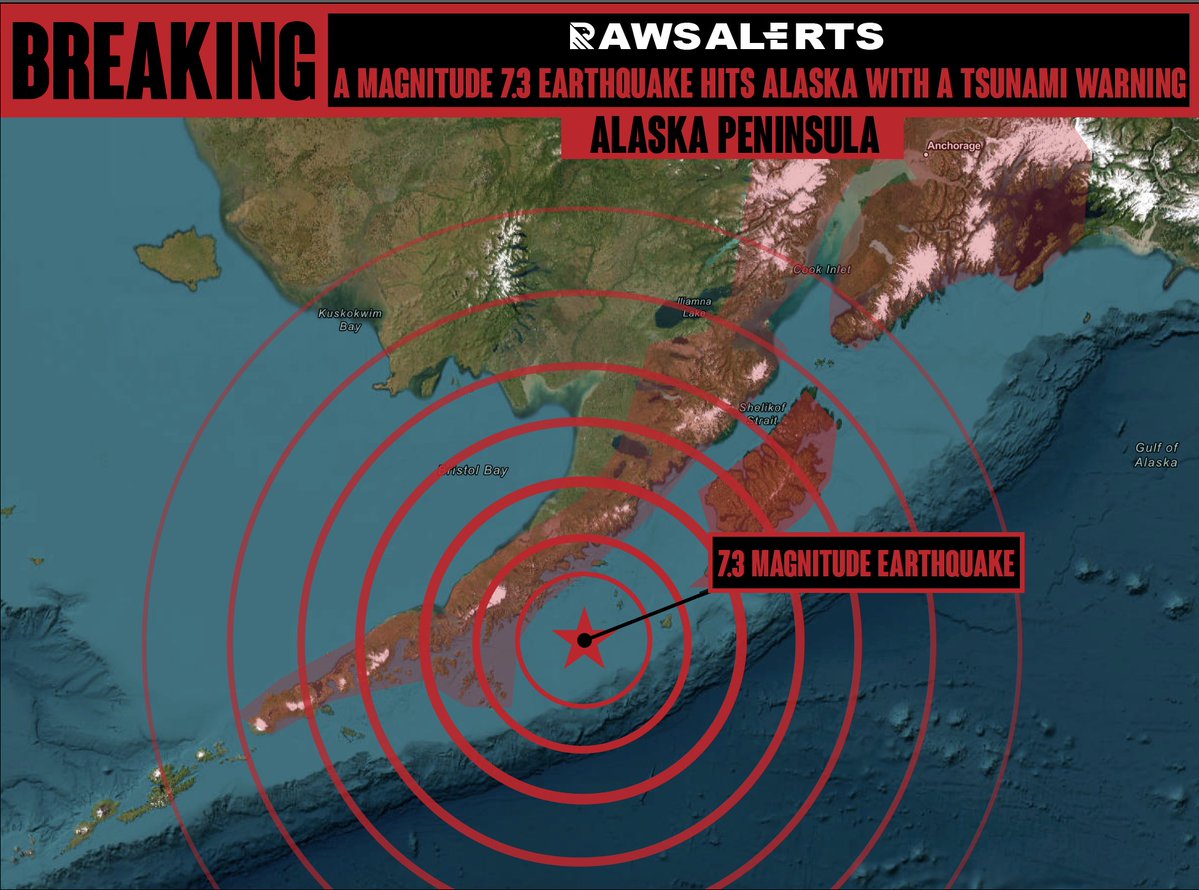
🚨#BREAKING: 7.3 magnitude earthquake hits the with a tsunami warning being issued 📌#Alaska | #Peninsula Sirens are currently blaring across parts of Alaska following a tsunami warning triggered by a powerful 7.3 magnitude earthquake off the state's coastline. The U.S. Tsunami

🚨#BREAKING: 7.3 magnitude earthquake hits the with a tsunami warning being issued

📌#Alaska | #Peninsula

Sirens are currently blaring across parts of Alaska following a tsunami warning triggered by a powerful 7.3 magnitude earthquake off the state's coastline. The U.S. Tsunami
NWS Anchorage (@nwsanchorage) 's Twitter Profile Photo

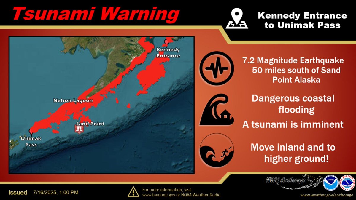
A Tsunami Warning has been issued for the Alaska Peninsula areas from the Kennedy Entrance to Unimak Pass. Cities included are Cold Bay, Sand Point, and Kodiak. We can say with reasonable confidence that the Kenai Peninsula Borough locations will not see impacts.

A Tsunami Warning has been issued for the Alaska Peninsula areas from the Kennedy Entrance to Unimak Pass. Cities included are Cold Bay, Sand Point, and Kodiak. We can say with reasonable confidence that the Kenai Peninsula Borough locations will not see impacts.
Collin Rugg (@collinrugg) 's Twitter Profile Photo

BREAKING: Residents in Sand Point, Alaska are being told to "move now" and get to higher ground immediately after a 7.3 earthquake was recorded off the coast. "If you are in that area, get to higher ground. Move now!"

NWS Tsunami Alerts (@nws_ntwc) 's Twitter Profile Photo

A TSUNAMI ADVISORY IS NOW IN EFFECT...  SOUTH ALASKA AND THE ALASKA PENINSULA, Pacific coasts from    Kennedy Entrance, AK to Unimak    Pass, Alaska Mag  7.3  * Origin Time    1238 AKDT Jul 16 2025  * Depth 12 miles  * Location       55 miles S of Sand Point, Alaska