USGS Coastal Change (@usgscoastchange) 's Twitter Profile
USGS Coastal Change

@usgscoastchange

We study hazards & resources: 95,000 miles of US coast & 4.5 million square miles of seabed. Retweets & likes not endorsements usgs.gov/policies-notic…

ID: 2649296311

linkhttps://usgs.gov calendar_today15-07-2014 21:43:37

3,3K Tweet

3,3K Followers

122 Following

USGS Coastal Change (@usgscoastchange) 's Twitter Profile Photo

For nearshore #bathymetric surveys, USGS uses jet skis with GPS + sonar to monitor coastal change in these dynamic settings. On-shore support staff watch for hazards and assist with launch/landing. Other on-shore support occasionally comes from the beach-going public...

USGS Coastal Change (@usgscoastchange) 's Twitter Profile Photo

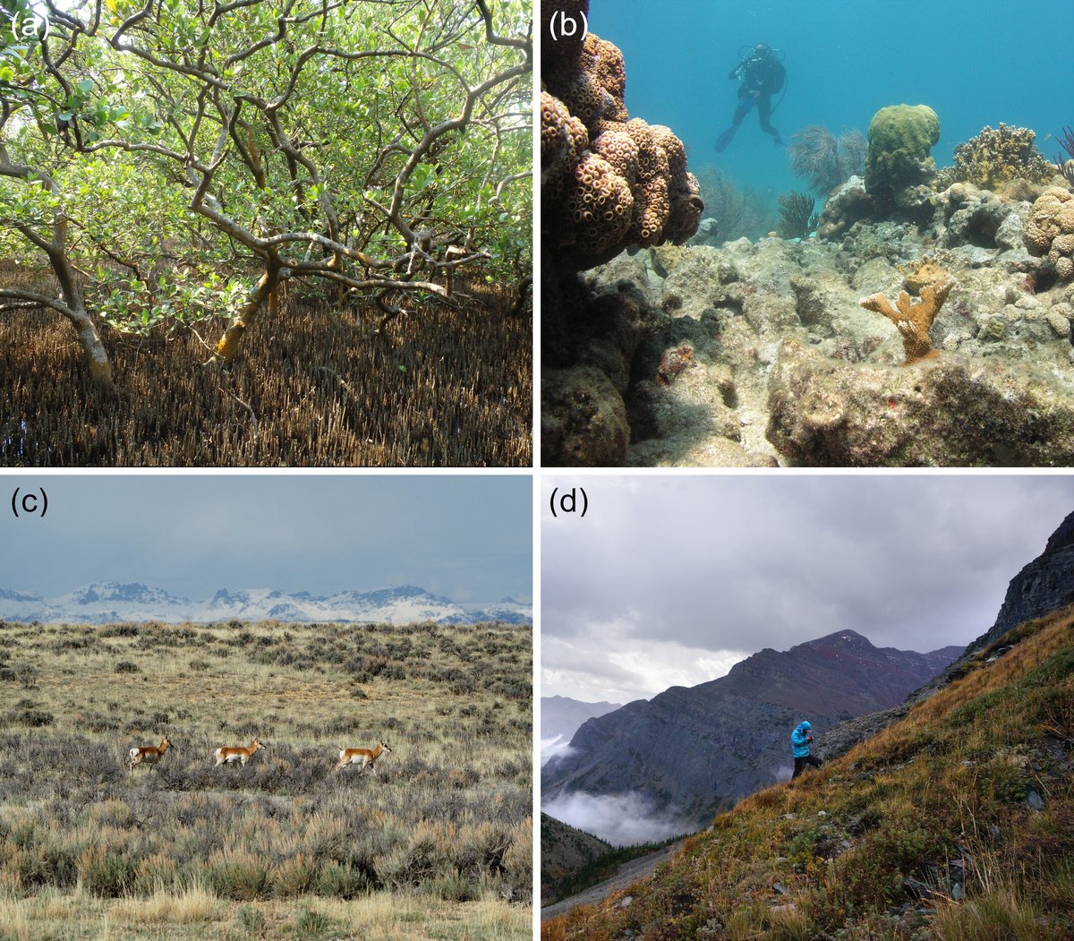
As #climatechange accelerates, the risk of sudden, large-scale shifts in #ecosystems is growing. A new USGS study examines the mechanisms behind these abrupt ecological transformations and offers a roadmap for predicting where and when they might occur: ow.ly/20H050WaR1u

As #climatechange accelerates, the risk of sudden, large-scale shifts in #ecosystems is growing. A new <a href="/USGS/">USGS</a> study examines the mechanisms behind these abrupt ecological transformations and offers a roadmap for predicting where and when they might occur: ow.ly/20H050WaR1u
USGS Coastal Change (@usgscoastchange) 's Twitter Profile Photo

#USGS conducts a variety of marine research that benefits our Nation by addressing disaster preparedness, resource assessment and management, economic development, and national security. 🌊 Learn more: ow.ly/iw5f50WcTtb #OceanMonth #oceanscience #marinescience

#USGS conducts a variety of marine research that benefits our Nation by addressing disaster preparedness, resource assessment and management, economic development, and national security.  

🌊 Learn more: ow.ly/iw5f50WcTtb  

#OceanMonth #oceanscience #marinescience
USGS Coastal Change (@usgscoastchange) 's Twitter Profile Photo

The USGS developed a workflow for creating 3D models of the deep #seafloor from archived video images. 🌊✨Learn more: ow.ly/4c4T50We9qN #OceanMonth #seafloormapping #USGS

The USGS developed a workflow for creating 3D models of the deep #seafloor from archived video images. 

🌊✨Learn more: ow.ly/4c4T50We9qN 

#OceanMonth #seafloormapping #USGS
USGS Coastal Change (@usgscoastchange) 's Twitter Profile Photo

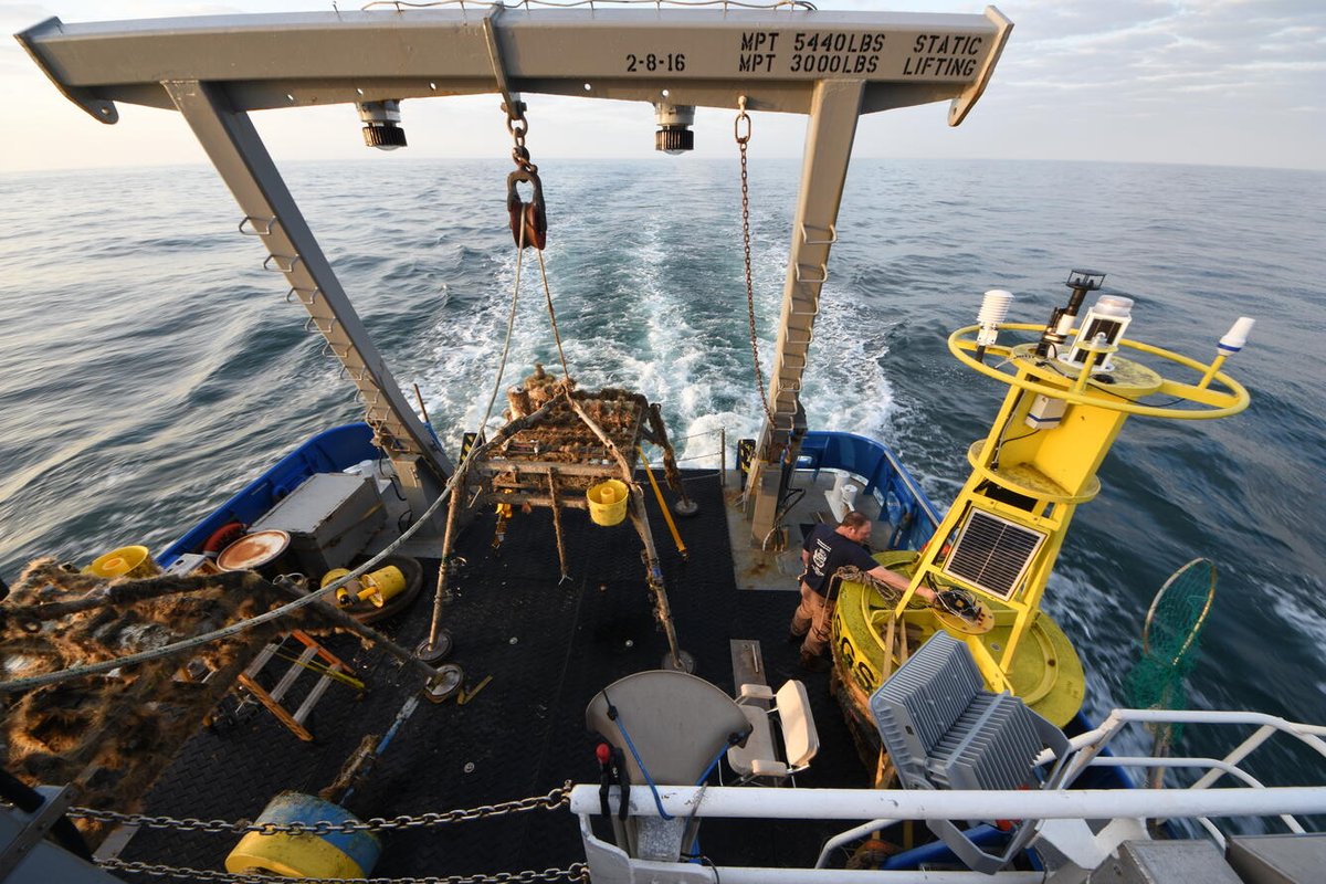
The SEABOSS—used to collect images, videos, and samples of the seafloor—is undergoing an update to increase overall capabilities and allow for deep water deployment up to 500 meters. 🌊✨Learn more: ow.ly/lkYG50We9c8 #OceanMonth #USGS

The SEABOSS—used to collect images, videos, and samples of the seafloor—is undergoing an update to increase overall capabilities and allow for deep water deployment up to 500 meters.  

🌊✨Learn more: ow.ly/lkYG50We9c8 

#OceanMonth  #USGS
USGS Coastal Change (@usgscoastchange) 's Twitter Profile Photo

#USGS marks the spot! Our science is key to understanding seabed resources. Our maps characterizing the #seafloor can help find #criticalminerals, precious metals, and other vital resources in high demand. 🌊✨Learn more: ow.ly/mHij50WcXRl #OceanMonth #seafloormapping

#USGS marks the spot! Our science is key to understanding seabed resources. Our maps characterizing the #seafloor can help find #criticalminerals, precious metals, and other vital resources in high demand. 

🌊✨Learn more: ow.ly/mHij50WcXRl 

#OceanMonth #seafloormapping
USGS Coastal Change (@usgscoastchange) 's Twitter Profile Photo

New research from CNES, USGS & Oregon State University uses decades of #satellitederivedshoreline data to show how #climate variability—particularly #ElNiño and #LaNiña atmospheric-circulation cycles—drives shoreline change along the North American #WestCoast: ow.ly/jpsI50WfHAo

New research from <a href="/CNES/">CNES</a>, <a href="/USGS/">USGS</a> &amp; <a href="/OregonState/">Oregon State University</a> uses decades of #satellitederivedshoreline data to show how #climate variability—particularly #ElNiño and #LaNiña atmospheric-circulation cycles—drives shoreline change along the North American #WestCoast: ow.ly/jpsI50WfHAo
USGS Coastal Change (@usgscoastchange) 's Twitter Profile Photo

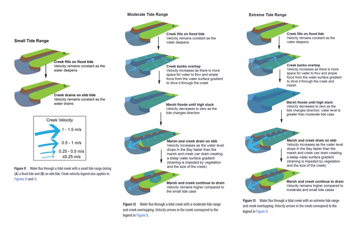
📢Just published by University of New Orleans, @USFCA, SF Bay National Estuarine Research Reserve, USGS, @SFBCDC 📢 - Marsh Sediment in Translation: A Review of Sediment Transport Across a Natural Tidal Salt Marsh in Northern San Francisco Bay ow.ly/qUMB50WgTs7

📢Just published by <a href="/UofNO/">University of New Orleans</a>, @USFCA, SF Bay National Estuarine Research Reserve, <a href="/USGS/">USGS</a>, @SFBCDC 📢 - Marsh Sediment in Translation: A Review of Sediment Transport Across a Natural Tidal Salt Marsh in Northern San Francisco Bay ow.ly/qUMB50WgTs7
USGS Coastal Change (@usgscoastchange) 's Twitter Profile Photo

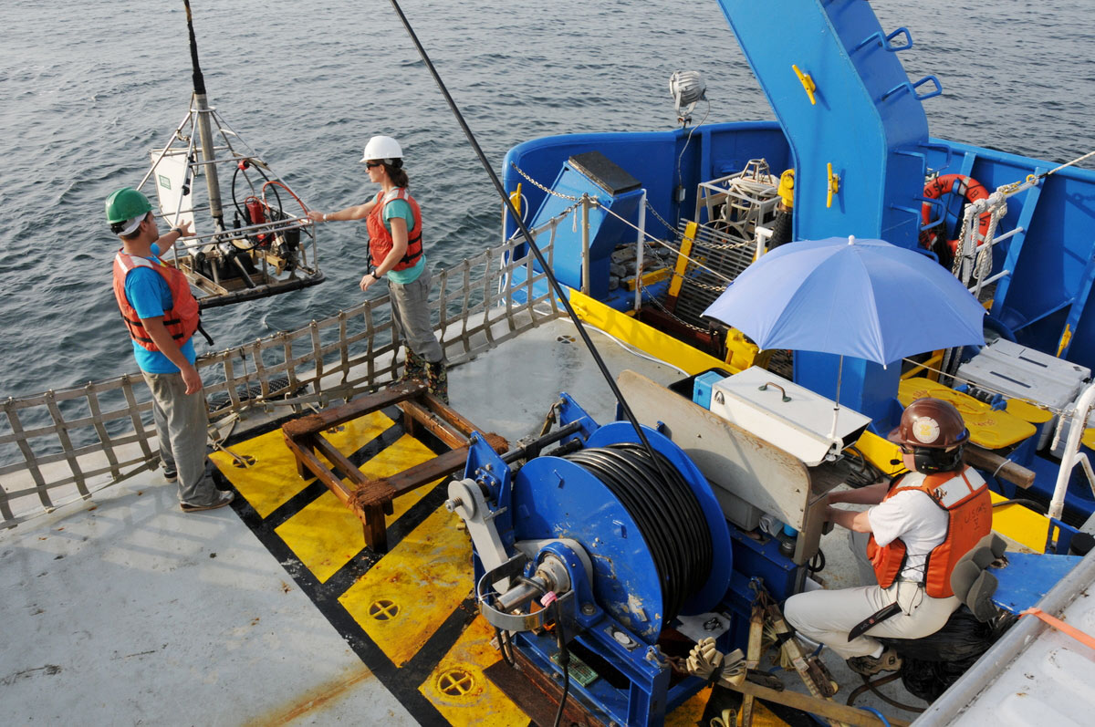
Ocean-bottom seismographs are valuable tools for studying marine geohazards like #earthquakes. The #USGS and #WHOI developed a small fleet of instruments to deploy quickly during seismic events. 🌊✨Read our story to learn more: ow.ly/ycHZ50We9MB #OceanMonth

Ocean-bottom seismographs are valuable tools for studying marine geohazards like #earthquakes. The #USGS and #WHOI developed a small fleet of instruments to deploy quickly during seismic events. 

🌊✨Read our story to learn more: ow.ly/ycHZ50We9MB 

#OceanMonth
USGS Coastal Change (@usgscoastchange) 's Twitter Profile Photo

The #USGS is actively #mapping the #seafloor in coastal to deep sea environments. These maps provide the scientific foundation needed to address national priorities, including #publicsafety, #nationalsecurity, and #economicprosperity. 🌊✨ow.ly/wnbI50WgXw1 #OceanMonth

The #USGS is actively #mapping the #seafloor in coastal to deep sea environments. These maps provide the scientific foundation needed to address national priorities, including #publicsafety, #nationalsecurity, and #economicprosperity. 

🌊✨ow.ly/wnbI50WgXw1  

#OceanMonth
USGS Coastal Change (@usgscoastchange) 's Twitter Profile Photo

A new #USGS study provides insights into how #hurricanes impact #barrierislands.🌊✨Read the article in JGR Earth Surface to learn more. ow.ly/FFgv50Wh0V9

A new #USGS study provides insights into how #hurricanes impact #barrierislands.🌊✨Read the article in JGR Earth Surface to learn more. ow.ly/FFgv50Wh0V9
USGS Coastal Change (@usgscoastchange) 's Twitter Profile Photo

In June 2025, a team of scientists led by USGS explored and characterized benthic communities, including deep sea corals, gas-seep communities, and seamounts near volcanoes along Alaska's #AleutianIslands: ow.ly/8YXL50WitCC #Alaska #deepseaexploration

In June 2025, a team of scientists led by <a href="/USGS/">USGS</a> explored and characterized benthic communities, including deep sea corals, gas-seep communities, and seamounts near volcanoes along Alaska's #AleutianIslands: ow.ly/8YXL50WitCC #Alaska #deepseaexploration
USGS Coastal Change (@usgscoastchange) 's Twitter Profile Photo

‼️Is your child texting about USGS Coastal and Marine science? 🌊 Know the shorthand ☝🏻 Jargon can be a lot—we get it. Check out these primers on our #coastalscience & #marinescience - Coasts: ow.ly/6y0j50Wj3tA Ocean: ow.ly/4bjW50Wj3tz

‼️Is your child texting about <a href="/USGS/">USGS</a> Coastal and Marine science? 🌊 Know the shorthand ☝🏻

Jargon can be a lot—we get it. Check out these primers on our #coastalscience &amp; #marinescience -

Coasts: ow.ly/6y0j50Wj3tA
Ocean: ow.ly/4bjW50Wj3tz
USGS Coastal Change (@usgscoastchange) 's Twitter Profile Photo

#Drones were used to collect aerial #remotesensing data over #SesuitMarsh in Dennis, MA to provide local partners with imagery and elevation data to monitor and identify vegetation cover of a #saltmarsh during peak growing season. 🌱✨Download data: ow.ly/glLS50WhyJN

#Drones were used to collect aerial #remotesensing data over #SesuitMarsh in Dennis, MA to provide local partners with imagery and elevation data to monitor and identify vegetation cover of a #saltmarsh during peak growing season. 

🌱✨Download data: ow.ly/glLS50WhyJN
USGS Coastal Change (@usgscoastchange) 's Twitter Profile Photo

Well, well. Contour us surprised. Who doesn't love a good map or two? And our topographic ones only scratch the surface (as it were). At USGS, we do all kinds of #mapping: subsurface geology, coastal hazard risk, land use...and yes, maps of the seafloor: ow.ly/OW7450WjJAf

USGS Coastal Change (@usgscoastchange) 's Twitter Profile Photo

The US @DepartofDefense uses USGS data to assess and respond to coastal infrastructure exposures and vulnerabilities from plausible scenarios of future mean sea level and extreme, storm-driven water levels in #Hawaii: ow.ly/a9tf50WjTTt

The US @DepartofDefense uses <a href="/USGS/">USGS</a> data to assess and respond to coastal infrastructure exposures and vulnerabilities from plausible scenarios of future mean sea level and extreme, storm-driven water levels in #Hawaii: ow.ly/a9tf50WjTTt
USGS Coastal Change (@usgscoastchange) 's Twitter Profile Photo

A #USGS study highlights the impacts of #hurricanes on #barrierislands, focusing on the #outwash process, where flooding from behind the dunes removes sand, plants, and seeds. 🌊✨Read the paper: ow.ly/J4tm50Whwze 🌊✨Download the data: ow.ly/6YU350Whwzf

A #USGS study highlights the impacts of #hurricanes on #barrierislands, focusing on the #outwash process, where flooding from behind the dunes removes sand, plants, and seeds. 

🌊✨Read the paper: ow.ly/J4tm50Whwze
🌊✨Download the data: ow.ly/6YU350Whwzf
USGS Coastal Change (@usgscoastchange) 's Twitter Profile Photo

A new #USGS study investigated the decomposition of #saltmarsh organic matter and found significant production of dissolved organic and inorganic #carbon and #methane, which supports export from #marshes to the #ocean. 🌿✨Read the study: ow.ly/U1t050WhB26.

A new #USGS study investigated the decomposition of #saltmarsh organic matter and found significant production of dissolved organic and inorganic #carbon and #methane, which supports export from #marshes to the #ocean.

🌿✨Read the study: ow.ly/U1t050WhB26.
USGS Coastal Change (@usgscoastchange) 's Twitter Profile Photo

Coastal communities around the world face increasing threats from #stormsurge — intense rises in sea level caused by powerful storms pushing water ashore. New research finds that storm surge likelihood is greatly underestimated along U.S. coasts: ow.ly/pgVL50WlJzT

USGS Coastal Change (@usgscoastchange) 's Twitter Profile Photo

#USGS social scientists interviewed marsh model users to learn what decisions they make about #marshes and how they use #marsh models in their work. 📊Learn more and download the data: ow.ly/8YVo50WlLEN. #saltmarsh #wetlands #socialscience #modeling

#USGS social scientists interviewed marsh model users to learn what decisions they make about #marshes and how they use #marsh models in their work.  

📊Learn more and download the data: ow.ly/8YVo50WlLEN. 

#saltmarsh #wetlands #socialscience #modeling