VOST EUROPE | #SMEM 🇪🇺 (@vosteurope) 's Twitter Profile
VOST EUROPE | #SMEM 🇪🇺

@vosteurope

European Virtual Operations Support Team | Digital volunteers from 🇪🇸🇫🇷🇩🇪🇵🇹🇸🇰 | Official account in Social Media in Emergency Management 🇪🇺 #SMEM

ID: 3375598691

linkhttps://vosteurope.org/ calendar_today14-07-2015 11:44:08

45,45K Tweet

6,6K Followers

1,1K Following

Hadja Lahbib (@hadjalahbib) 's Twitter Profile Photo

In recent weeks, the EU has mobilised firefighting assistance for Bulgaria, Greece, Cyprus & beyond. EU-prepositioned firefighters & #rescEU assets have made a real difference on the ground, protecting people and the environment. Preparedness & European solidarity save lives!

In recent weeks, the EU has mobilised firefighting assistance for Bulgaria, Greece, Cyprus & beyond. 

EU-prepositioned firefighters & #rescEU assets have made a real difference on the ground, protecting people and the environment. 

Preparedness & European solidarity save lives!
Ursula von der Leyen (@vonderleyen) 's Twitter Profile Photo

Europe stands with France as the worst wildfires in its recent history rage in Aude. My thoughts are with the brave firefighters as they battle the blaze. We are ready to mobilise rescEU resources to support efforts to bring the fires under control.

Copernicus EMS (@copernicusems) 's Twitter Profile Photo

Each year, #EFAS partners provide valuable feedback to help shape the future of the service. In 2024, we received a record 76 responses — more than ever before! 🔍 Read the full results: european-flood.emergency.copernicus.eu/en/news/efas-p… 🛠️ See the improvements made in response: european-flood.emergency.copernicus.eu/en/improvement…
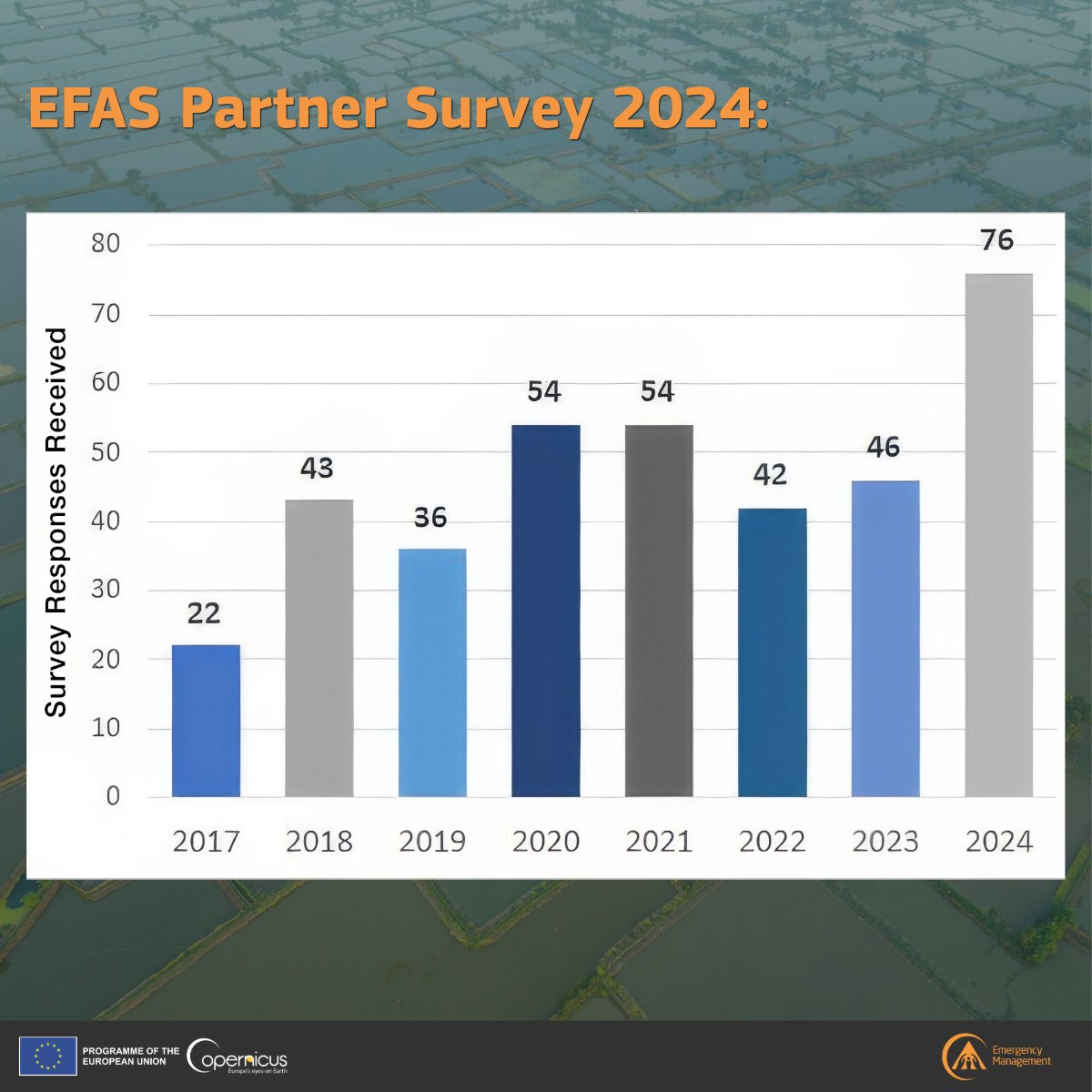
Each year, #EFAS partners provide valuable feedback to help shape the future of the service. In 2024, we received a record 76 responses — more than ever before!

🔍 Read the full results:
 european-flood.emergency.copernicus.eu/en/news/efas-p…

🛠️ See the improvements made in response:
 european-flood.emergency.copernicus.eu/en/improvement…
Copernicus EMS (@copernicusems) 's Twitter Profile Photo

🔥 Update – #EMSR816 🇦🇱 #Grading by our #MappingTeam shows that the fire in Gurë-Lurë impacted mainly shrubland (>65%) & forest (>30%). A total of 2,957.3 ha have burned in the #AOI since 23 July. 🔗 rapidmapping.emergency.copernicus.eu/EMSR816/report…

🔥 Update – #EMSR816 🇦🇱

#Grading by our #MappingTeam shows that the fire in Gurë-Lurë impacted mainly shrubland (>65%) & forest (>30%). A total of 2,957.3 ha have burned in the #AOI since 23 July.

🔗 rapidmapping.emergency.copernicus.eu/EMSR816/report…
Copernicus EU (@copernicuseu) 's Twitter Profile Photo

📢#SaveTheDate for the 4⃣th and final webinar of the EU 🇪🇺 #OceanDecade 🌊 series on 25 Sep! Experts will demonstrate how to use #CopernicusEU #OpenData 🛰️ to address the #OceanDecade Challenges 7-10 & to advance our knowledge of the ocean. Register 👇 eudata4oceandecade.eu

📢#SaveTheDate for the 4⃣th and final webinar of  the EU 🇪🇺 #OceanDecade 🌊 series on 25 Sep!

Experts will demonstrate how to use #CopernicusEU #OpenData 🛰️ to address the #OceanDecade Challenges 7-10 & to advance our knowledge of the ocean.

Register 👇
eudata4oceandecade.eu
Copernicus EMS (@copernicusems) 's Twitter Profile Photo

🔥 #EMSR826 – Wildfire in Spain 🇪🇸 On 28 July, a wildfire started in Cuevas del Valle, Castilla y León, and burned for four days. Our #MappingTeam is requested to provide detailed emergency maps of the affected surface and vegetation. 🔗rapidmapping.emergency.copernicus.eu/EMSR826/report…

🔥 #EMSR826 – Wildfire in Spain 🇪🇸

On 28 July, a wildfire started in Cuevas del Valle, Castilla y León, and burned for four days. Our #MappingTeam is requested to provide detailed emergency maps of the affected surface and vegetation.

🔗rapidmapping.emergency.copernicus.eu/EMSR826/report…
Copernicus EU (@copernicuseu) 's Twitter Profile Photo

🇫🇮 Lake Rautavesi in Finland is a popular spot for fishing and swimming. The area was shaped by melting ice. The soils are likewise influenced by these ice age dynamics, resulting a contrast between the agricultural areas & the forests. #CopernicusEU #ImageOfTheDay

🇫🇮 Lake Rautavesi in Finland is a popular spot for fishing and swimming. The area was shaped by melting ice. The soils are likewise influenced by these ice age dynamics, resulting a contrast between the agricultural areas & the forests. #CopernicusEU #ImageOfTheDay
🇪🇺 EU Defence and Space (@defis_eu) 's Twitter Profile Photo

🌍 Meet Copernicus - Europe’s eye on Earth and a key component of the #EUSpace Programme! 🎥 Watch the video to see how #CopernicusEU keeps a close watch on our planet - and why that’s essential for us all. Learn more: copernicus.eu

Copernicus EMS (@copernicusems) 's Twitter Profile Photo

🎸 #EMSR827 – Public Event in Bavaria 🇩🇪 From 13–16 August, the Summer Breeze Festival in Dinkelsbühl will welcome tens of thousands of attendees. 🛰️ Our #MappingTeam is activated to provide emergency mapping for event monitoring and safety. 🔗rapidmapping.emergency.copernicus.eu/EMSR827/report…

🎸 #EMSR827 – Public Event in Bavaria 🇩🇪

From 13–16 August, the Summer Breeze Festival in Dinkelsbühl will welcome tens of thousands of attendees.

🛰️ Our #MappingTeam is activated to provide emergency mapping for event monitoring and safety.

🔗rapidmapping.emergency.copernicus.eu/EMSR827/report…
EU Civil Protection & Humanitarian Aid 🇪🇺 (@eu_echo) 's Twitter Profile Photo

🔥Weekly wildfire update in Europe Since the beginning of the year: 📍 1,599 fires 🌍 409,220 ha burnt 🌫️13.47 Mt of CO2 emitted Fire danger forecast for the next 7 days ⬇️ We are monitoring closely and stand ready to assist. #EUCivilProtection More: europa.eu/!HRmFq6

🔥Weekly wildfire update in Europe

Since the beginning of the year:
📍 1,599 fires
🌍 409,220 ha burnt
🌫️13.47 Mt of CO2 emitted

Fire danger forecast for the next 7 days ⬇️

We are monitoring closely and stand ready to assist.

#EUCivilProtection

More: europa.eu/!HRmFq6
Copernicus EMS (@copernicusems) 's Twitter Profile Photo

🔥 #EMSR830 – Wildfire near Terzigno, Italy 🇮🇹 Satellite analysis shows 554 ha burned and 32 active flames near densely populated areas by Mount Vesuvius. Our #RapidMapping is supporting authorities with damage assessment and fire extent mapping. 🔗rapidmapping.emergency.copernicus.eu/EMSR830/report…

🔥 #EMSR830 – Wildfire near Terzigno, Italy 🇮🇹

Satellite analysis shows 554 ha burned and 32 active flames near densely populated areas by Mount Vesuvius.

Our #RapidMapping is supporting authorities with damage assessment and fire extent mapping.

🔗rapidmapping.emergency.copernicus.eu/EMSR830/report…
Hadja Lahbib (@hadjalahbib) 's Twitter Profile Photo

Due to strong winds, fires in #Montenegro are spreading rapidly. A helicopter from Serbia🇷🇸 and #rescEU planes from Croatia🇭🇷 and Italy🇮🇹 are now deployed to 🇲🇪 via the 🇪🇺Civil Protection Mechanism.   As wildfire danger looms over Europe, we stand ready to respond where needed.

EU Civil Protection & Humanitarian Aid 🇪🇺 (@eu_echo) 's Twitter Profile Photo

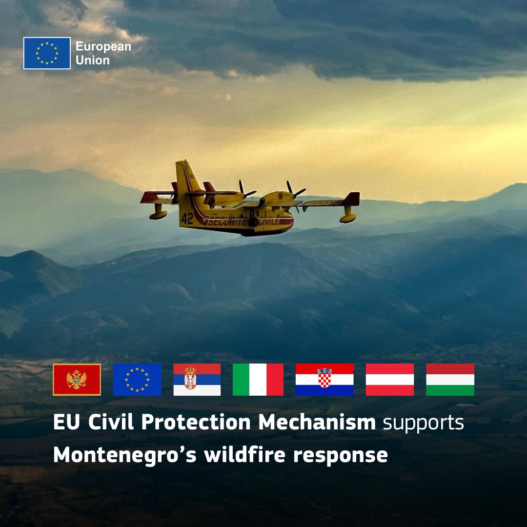
Relentless flames keep burning around Montenegro’s capital. We have mobilised emergency assistance to Montenegro via its #EUCivilProtection Mechanism: 🔹#rescEU firefighting planes from 🇭🇷 and 🇮🇹 🔹helicopters from 🇷🇸 and 🇭🇺 🔹forest firefighting team from 🇦🇹. #EUSolidarity

Relentless flames keep burning around Montenegro’s capital.

We have mobilised emergency assistance to Montenegro via its #EUCivilProtection Mechanism:

🔹#rescEU firefighting planes from 🇭🇷 and 🇮🇹
🔹helicopters from 🇷🇸 and 🇭🇺
🔹forest firefighting team from 🇦🇹.

#EUSolidarity
Copernicus EMS (@copernicusems) 's Twitter Profile Photo

🔥#EMSR832 – Wildfire in Zakynthos🇬🇷 A fast-spreading blaze near Keri & Agalas has forced evacuations. Ground & aerial firefighting teams are battling the flames amid extreme fire danger. #MappingTeam is activated to assess the impact & support response: rapidmapping.emergency.copernicus.eu/EMSR832

🔥#EMSR832 – Wildfire in Zakynthos🇬🇷

A fast-spreading blaze near Keri & Agalas has forced evacuations. Ground & aerial firefighting teams are battling the flames amid extreme fire danger.

#MappingTeam is activated to assess the impact & support response:
rapidmapping.emergency.copernicus.eu/EMSR832
Copernicus EMS (@copernicusems) 's Twitter Profile Photo

🔥#EMSR833 – Wildfire in Western Greece🇬🇷 A fast-moving blaze near Agios Stefanos & surrounding villages has forced evacuations. 🚒 Ground & aerial crews are battling multiple fires across the region. #MappingTeam is activated to assess impact: rapidmapping.emergency.copernicus.eu/EMSR833

🔥#EMSR833 – Wildfire in Western Greece🇬🇷

A fast-moving blaze near Agios Stefanos & surrounding villages has forced evacuations.

🚒 Ground & aerial crews are battling multiple fires across the region. #MappingTeam is activated to assess impact:
 rapidmapping.emergency.copernicus.eu/EMSR833
Copernicus EMS (@copernicusems) 's Twitter Profile Photo

🔥#EMSR834 – Wildfire in Chios🇬🇷 A fast-spreading fire near Nea Potamia is threatening several settlements, forcing evacuations and damaging buildings, infrastructure, and forests. 🛰️#MappingTeam is activated to assess the extent and support response: rapidmapping.emergency.copernicus.eu/EMSR834

🔥#EMSR834 – Wildfire in Chios🇬🇷

A fast-spreading fire near Nea Potamia is threatening several settlements, forcing evacuations and damaging buildings, infrastructure, and forests.

🛰️#MappingTeam is activated to assess the extent and support response:
 rapidmapping.emergency.copernicus.eu/EMSR834
Copernicus EMS (@copernicusems) 's Twitter Profile Photo

🔥 #EMSR833 – Wildfire in Western Greece 🇬🇷 Our latest map shows a burnt area of 922 ha near Agios Stefanos, with ~200 people potentially affected. 🛰️#MappingTeam continues to monitor and assess the impact to support emergency services. 🔗rapidmapping.emergency.copernicus.eu/EMSR833

🔥 #EMSR833 – Wildfire in Western Greece 🇬🇷

Our latest map shows a burnt area of 922 ha near Agios Stefanos, with ~200 people potentially affected.

🛰️#MappingTeam continues to monitor and assess the impact to support emergency services.

🔗rapidmapping.emergency.copernicus.eu/EMSR833
Copernicus EMS (@copernicusems) 's Twitter Profile Photo

🔥 #EMSR834 – Wildfire in Chios 🇬🇷 Satellite mapping shows 4,246.6 ha burnt near Volissos, with ~200 people potentially affected. Active flames were detected along 2 km of fire fronts, and over 90 km of roads may be impacted. More info on our website: rapidmapping.emergency.copernicus.eu/EMSR834/report…

🔥 #EMSR834 – Wildfire in Chios 🇬🇷

Satellite mapping shows 4,246.6 ha burnt near Volissos, with ~200 people potentially affected.

Active flames were detected along 2 km of fire fronts, and over 90 km of roads may be impacted.

More info on our website: rapidmapping.emergency.copernicus.eu/EMSR834/report…