Women in Geographic Information Systems Uganda (@wigis_ug) 's Twitter Profile
Women in Geographic Information Systems Uganda

@wigis_ug

Connect. Learn. Impact

ID: 1290160351913414658

calendar_today03-08-2020 05:40:01

1,1K Tweet

861 Followers

485 Following

Mashford Mahute (@mashfordmahute) 's Twitter Profile Photo

The #SDGs are a universal call to action to end #poverty, protect the #planet, and ensure peace and prosperity for all. But how do we track progress, identify challenges, and drive #data-driven decisions for each goal? The answer lies in Geographic Information Systems (#GIS)!

The #SDGs are a universal call to action to end #poverty, protect the #planet, and ensure peace and prosperity for all. 

But how do we track progress, identify challenges, and drive #data-driven decisions for each goal? 

The answer lies in Geographic Information Systems (#GIS)!
FAO Forestry (@faoforestry) 's Twitter Profile Photo

1/3 of the global population relies on forests for their subsistence and income. They are more likely to face poverty and inequality. Harmonizing #SocialProtection with forest policy is a solution towards agrifood systems transformation. More 👉 ow.ly/1XHI50SS5v4

1/3 of the global population relies on forests for their subsistence and income.

They are more likely to face poverty and inequality.

Harmonizing #SocialProtection with forest policy is a solution towards agrifood systems transformation.

More 👉 ow.ly/1XHI50SS5v4
Kaluba Micheal (@micheal_kaluba) 's Twitter Profile Photo

🎉 Happy International Museums Day! We're proud to showcase our collaborative project between Wikimedia Community User Group Uganda (WCUGU) and Uganda Community Museums Association (UCOMA) mapping Uganda’s community museums. 🗺️🏛️

🎉 Happy International Museums Day!
 We're proud to showcase our collaborative project between Wikimedia Community User Group Uganda (WCUGU) and Uganda Community Museums Association (UCOMA) mapping Uganda’s community museums. 🗺️🏛️
Women in Geographic Information Systems Uganda (@wigis_ug) 's Twitter Profile Photo

Wetlands are some of the critical environmental assets that need to be conserved and protected for their ecological and socioeconomic benefits! Kampala Capital City Authority (KCCA) is developing a wetlands strategy for GKMA and we are glad to be part of this process kudos Flavia Zabali Musisi and team!

Wetlands are some of the critical environmental assets that need to be conserved and protected for their ecological and socioeconomic benefits! <a href="/KCCAUG/">Kampala Capital City Authority (KCCA)</a> is developing a wetlands strategy for GKMA and we are glad to be part of this process kudos <a href="/FlaviaZabali/">Flavia Zabali Musisi</a> and team!
Women in Geographic Information Systems Uganda (@wigis_ug) 's Twitter Profile Photo

To all environment stewards out there who take their time and resources to save the environment from #PlasticPollution we see you, we recognize you and we are here to say thank you! #WorldEnvironmentDay2025 #BeatPlasticPollution

To all environment stewards out there who take their time and resources to save the environment from #PlasticPollution we see you, we recognize you and we are here to say thank you! #WorldEnvironmentDay2025 #BeatPlasticPollution
SotM Africa 2025 (@sotmafrica) 's Twitter Profile Photo

🌍 Scholarship applications are OPEN for #SotMAfrica2025 in Dar es Salaam, Tanzania (Nov 28 - 30)! We're offering Partial & Full scholarships to boost African representation. Don't miss out! Apply by July 31st! 🔗 forms.gle/MBXC9YbLq6k9j6…

🌍 Scholarship applications are OPEN for #SotMAfrica2025 in Dar es Salaam, Tanzania (Nov 28 - 30)! We're offering Partial &amp; Full scholarships to boost African representation. Don't miss out! Apply by July 31st! 🔗 forms.gle/MBXC9YbLq6k9j6…
YouthMappers (@youthmappers) 's Twitter Profile Photo

Calling all YouthMappers across Africa! Apply now for the #SotMAfrica2025 Scholarship. 🗓️ Deadline: July 31 📍Tanzania 🔗 forms.gle/MBXC9YbLq6k9j6… Show how you're putting communities on the map! #OpenStreetMap #OSMAfrica #MappingForChange


Calling all <a href="/youthmappers/">YouthMappers</a> across Africa!
Apply now for the #SotMAfrica2025 Scholarship.
🗓️ Deadline: July 31
📍Tanzania
🔗 forms.gle/MBXC9YbLq6k9j6…
Show how you're putting communities on the map!

#OpenStreetMap #OSMAfrica #MappingForChange
EOTEC DevNet (@eotecdevnet) 's Twitter Profile Photo

🌍 Help improve the EO Dashboard! Share your feedback on potential new features, including AI tools and user experience upgrades. 🕐 Survey takes ~4 minutes 📊 Your input will help shape future updates 🔗 forms.office.com/Pages/Response… #EODashboard #EarthObservation #AI4EO

🌍 Help improve the EO Dashboard! Share your feedback on potential new features, including AI tools and user experience upgrades.

🕐 Survey takes ~4 minutes
📊 Your input will help shape future updates
🔗 forms.office.com/Pages/Response… 

#EODashboard #EarthObservation #AI4EO
Md Mijanur Rahman🛰️🗺️🛰️ (@gisrsstudyhacks) 's Twitter Profile Photo

Urban Development & Growth Monitoring with Google Earth Engine | Remote Sensing Tutorial Tutorial Link: youtube.com/live/cR9eRNqmr… For more information, visit our website: studyhacksgeospatial.com/google-earth-e… #GoogleEarthEngine #RemoteSensing #FloodMonitoring #WaterLogging #GIS #ClimateAction

Urban Development &amp; Growth Monitoring with Google Earth Engine | Remote Sensing Tutorial
Tutorial Link: youtube.com/live/cR9eRNqmr…
For more information, visit our website: 
studyhacksgeospatial.com/google-earth-e… 
#GoogleEarthEngine #RemoteSensing #FloodMonitoring #WaterLogging #GIS #ClimateAction
Md Mijanur Rahman🛰️🗺️🛰️ (@gisrsstudyhacks) 's Twitter Profile Photo

Water Resource Management using Google Earth Engine || Flood Mapping and Water Logging detection Tutorial link: youtube.com/live/VIjcmQlOx… For more information, visit our website: studyhacksgeospatial.com/google-earth-e… #GoogleEarthEngine #WaterResourceManagement #FloodMapping #WaterLogging

Water Resource Management using Google Earth Engine || Flood Mapping and Water Logging detection
Tutorial link: youtube.com/live/VIjcmQlOx…
For more information, visit our website: studyhacksgeospatial.com/google-earth-e…
#GoogleEarthEngine #WaterResourceManagement #FloodMapping #WaterLogging
EOTEC DevNet (@eotecdevnet) 's Twitter Profile Photo

NASA ARSET trainings are now available on NASAEarthdata 🌍 Explore 25+ EO training topics, including air quality, wildfire, and biodiversity. 🔗 earthdata.nasa.gov/data/projects/… #ARSET #EOTraining #EarthObservation #CapacityBuilding #EOTECDevNet

Mashford Mahute (@mashfordmahute) 's Twitter Profile Photo

🌍 What does Africa look like when we map where people actually live? Here's a glowing population map of our beautiful continent, built using WorldPop data and styled in QGIS. #GIS #Geospatial #QGIS #ArcGIS #Python #RemoteSensing #Africa #Population

🌍 What does Africa look like when we map where people actually live?

 Here's a glowing population map of our beautiful continent, built using WorldPop data and styled in QGIS.

#GIS #Geospatial #QGIS #ArcGIS #Python #RemoteSensing #Africa #Population
SDGs Today (@sdgstoday) 's Twitter Profile Photo

🌐 Join @SDGsToday, Statistics Maldives & EU_ScienceHub for an #HLPF2025 virtual side event! Explore how non-traditional data drives: 🔹 Research & capacity-building 🔹 SDG monitoring 🔹 Evidence-based policymaking 📅July 15 🕐8 AM EST 🔗sdgstoday.org/event/2025hlpf UN DESA Sustainable Development UNStats
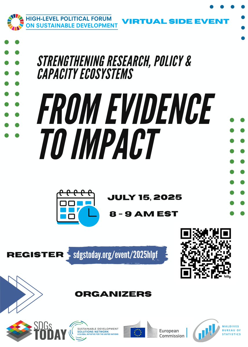
🌐 Join @SDGsToday, <a href="/statsmaldives/">Statistics Maldives</a> &amp; <a href="/EU_ScienceHub/">EU_ScienceHub</a> for an #HLPF2025 virtual side event! Explore how non-traditional data drives:
🔹 Research &amp; capacity-building
🔹 SDG monitoring
🔹 Evidence-based policymaking

📅July 15
🕐8 AM EST
🔗sdgstoday.org/event/2025hlpf

<a href="/SustDev/">UN DESA Sustainable Development</a> <a href="/UNStats/">UNStats</a>
Md Mijanur Rahman🛰️🗺️🛰️ (@gisrsstudyhacks) 's Twitter Profile Photo

#RemoteSensing #Geology #EarthObservation #GoogleEarthEngine #Hyperspectral #Geoscience #MineralExploration #Volcanology #Hydrogeology #SatelliteImagery #Geospatial #GeologicalMapping #EngineeringGeology

#RemoteSensing #Geology #EarthObservation #GoogleEarthEngine #Hyperspectral #Geoscience #MineralExploration #Volcanology #Hydrogeology #SatelliteImagery #Geospatial #GeologicalMapping #EngineeringGeology
GGGI Uganda (@gggiuganda) 's Twitter Profile Photo

🌿 Join us for the 4th Annual #WiCC Conference 2025 & engage in a dialogue on: Women-led #innovativesolutions, Local to Global #Climate Leadership panel, WiCC Action Plan & more. 📅 Thursday, July 24, 2025 ⏰ 8:30 AM – 5:00 PM EAT | 💻 Zoom 🔗 Register: bit.ly/405LKuv

🌿 Join us for the 4th Annual #WiCC Conference 2025 &amp; engage in a dialogue on: Women-led #innovativesolutions, Local to Global #Climate Leadership panel, WiCC Action Plan &amp; more.

📅 Thursday, July 24, 2025
⏰ 8:30 AM – 5:00 PM EAT | 💻 Zoom
🔗 Register: bit.ly/405LKuv
Md Mijanur Rahman🛰️🗺️🛰️ (@gisrsstudyhacks) 's Twitter Profile Photo

For more information about registration, visit our website: studyhacksgeospatial.com/google-earth-e… #GoogleEarthEngine #RemoteSensing #GIS #GeospatialTraining #OnlineTraining #EarthObservation #SatelliteImagery #GEEforBeginners #GEEwithPython #GEEwithJavaScript #NDVI #LULCMapping

For more information about registration, visit our website: studyhacksgeospatial.com/google-earth-e…
#GoogleEarthEngine #RemoteSensing #GIS #GeospatialTraining #OnlineTraining #EarthObservation #SatelliteImagery #GEEforBeginners #GEEwithPython #GEEwithJavaScript #NDVI #LULCMapping
National Forestry Authority-Uganda (@nfaug) 's Twitter Profile Photo

TREES MATTER Trees are essential for life as they provide clean air, protect the environment, support biodiversity, sustain livelihoods, enhance well being and help communities adapt to climate change. #Forestsforgenerations

TREES MATTER

Trees are essential for life as they provide clean air, protect the environment, support biodiversity, sustain livelihoods, enhance well being and help communities adapt to climate change. #Forestsforgenerations
Yohan (@yohaniddawela) 's Twitter Profile Photo

High-resolution satellite images can be insanely expensive to buy. So here's a list of free datasets you can access. These datasets can be used to build foundation models, super-resolution models, or for segmentation.

High-resolution satellite images can be insanely expensive to buy.

So here's a list of free datasets you can access.

These datasets can be used to build foundation models, super-resolution models, or for segmentation.