Zach Covey (@zachcoveytv) 's Twitter Profile
Zach Covey

@zachcoveytv

| Hurricane Specialist | Spectrum News | @FloridaState Alumnus

ID: 789581786540113920

calendar_today21-10-2016 21:39:02

36,36K Tweet

13,13K Followers

3,3K Following
National Hurricane Center (@nhc_atlantic) 's Twitter Profile Photo

8/3 2pm- The Tropics are heating up with 3 systems that we are monitoring. #AL95 offshore of the Carolinas has a high chance of becoming a TS by Monday as it moves away from the US. Two other systems have some development potential this week- More: hurricanes.gov

8/3 2pm- The Tropics are heating up with 3 systems that we are monitoring.  #AL95 offshore of the Carolinas has a high chance of becoming a TS by Monday as it moves away from the US.  Two other systems have some development potential this week- More: hurricanes.gov
National Hurricane Center (@nhc_atlantic) 's Twitter Profile Photo

Tropical Storm #Dexter Advisory 1: Tropical Storm Dexter Forms Over the Western Atlantic. Forecast to Move Away From the U. S. Coast and Stay North Of Bermuda. hurricanes.gov

Philip Klotzbach (@philklotzbach) 's Twitter Profile Photo

Tropical Storm #Dexter has formed off of the North Carolina coast - the 4th Atlantic named storm of the 2025 #hurricane season. On average, the 4th Atlantic named storm forms on 15 August. No hurricanes have formed in the Atlantic yet this year. Average 1st hurricane is 11 August

Zach Covey (@zachcoveytv) 's Twitter Profile Photo

Certainly feels like August with a map like this. No concerns for the U.S. though! But a great reminder that the tropics will begin to heat up heading into the next 2 months. #tropics #FLwx @mynews13

Certainly feels like August with a map like this. No concerns for the U.S. though! 

But a great reminder that the tropics will begin to heat up heading into the next 2 months. #tropics #FLwx @mynews13
Zach Covey (@zachcoveytv) 's Twitter Profile Photo

The wave coming off Africa that so many people want to talk about is still roughly 12-14 days away from the U.S. coastline. So yeah, I'm not too worried about anything just yet. #tropics #FLwx @mynews13

The wave coming off Africa that so many people want to talk about is still roughly 12-14 days away from the U.S. coastline. 

So yeah, I'm not too worried about anything just yet. #tropics #FLwx @mynews13
Zach Covey (@zachcoveytv) 's Twitter Profile Photo

Florida’s first seabreeze hurricane of the year? This thing is ROCKING my house right now with wind and thunder! #FLwx

Zach Covey (@zachcoveytv) 's Twitter Profile Photo

The past 24 hours shows me that the majority of Americans don’t understand how to read a map and its legend. And that should be a lesson to every meteorologist. Make your maps and legends easy to understand. If the public doesn’t understand, then the message gets lost.

Zach Covey (@zachcoveytv) 's Twitter Profile Photo

BREAKING | NWS Melbourne officially rated yesterday's tornado in Osceola county as an EF-U due to limited access to the affected area. #FLwx @mynews13
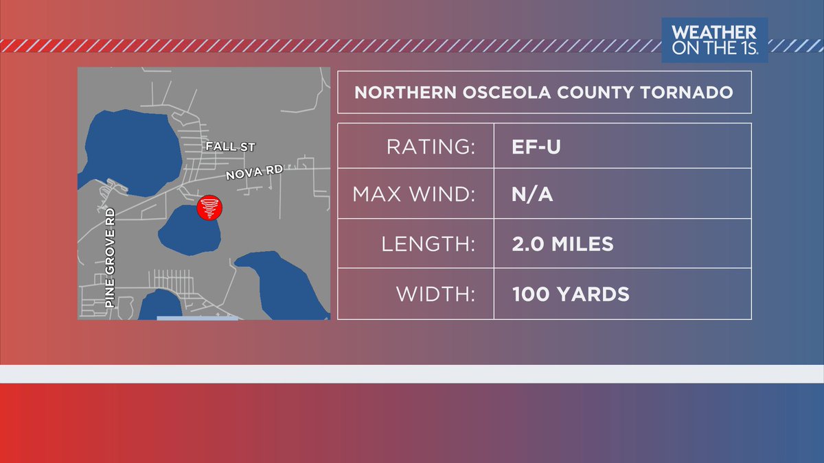
BREAKING | <a href="/NWSMelbourne/">NWS Melbourne</a> officially rated yesterday's tornado in Osceola county as an EF-U due to limited access to the affected area. #FLwx @mynews13
Zach Covey (@zachcoveytv) 's Twitter Profile Photo

We've got a mission scheduled into our disturbance off the southeast coast of the United States. Tomorrow, the Hurricane Hunters will fly around and sample the environment, which should help give us a better clue of what's going on here. #FLwx #tropics @mynews13

We've got a mission scheduled into our disturbance off the southeast coast of the United States. 

Tomorrow, the Hurricane Hunters will fly around and sample the environment, which should help give us a better clue of what's going on here. #FLwx #tropics @mynews13
B (@briancas120) 's Twitter Profile Photo

James Spann Zach Covey Lightning streak illuminates sky above trees looking south near Kissimmee, Florida towards seabreeze storm after sunset tonight.

<a href="/spann/">James Spann</a> <a href="/ZachCoveyTV/">Zach Covey</a> 

Lightning streak illuminates sky above trees looking south near Kissimmee, Florida towards seabreeze storm after sunset tonight.
Philip Klotzbach (@philklotzbach) 's Twitter Profile Photo

CSU continues to predict slightly above-normal Atlantic season, with 16 named storms (including 4 that have formed), 8 hurricanes and 3 major (Category 3+ hurricanes): tropical.colostate.edu/Forecast/2025-… Relatively warm Atlantic and likely absence of #ElNino the primary factors.

CSU continues to predict slightly above-normal Atlantic season, with 16 named storms (including 4 that have formed), 8 hurricanes and 3 major (Category 3+ hurricanes):  
tropical.colostate.edu/Forecast/2025-… 
Relatively warm Atlantic and likely absence of #ElNino  the primary factors.
National Hurricane Center (@nhc_atlantic) 's Twitter Profile Photo

8 pm EDT - In addition to Tropical Storm #Dexter, NHC is monitoring two other systems. Both of these are not expected to affect land during the next several days. Visit hurricanes.gov for updates.

8 pm EDT - In addition to Tropical Storm #Dexter, NHC is monitoring two other systems.  Both of these are not expected to affect land during the next several days.  Visit hurricanes.gov for updates.
Nick Stewart (@nstewwx) 's Twitter Profile Photo

A preliminary, manual quality control of this lightning strike captured by NSF - NASASpaceflight.com cameras show a span of 140.1km/87.1mi, originating off the coast from a thunderstorm and traveling along the anvil towards the Orlando metro area. This is by far the longest span I have
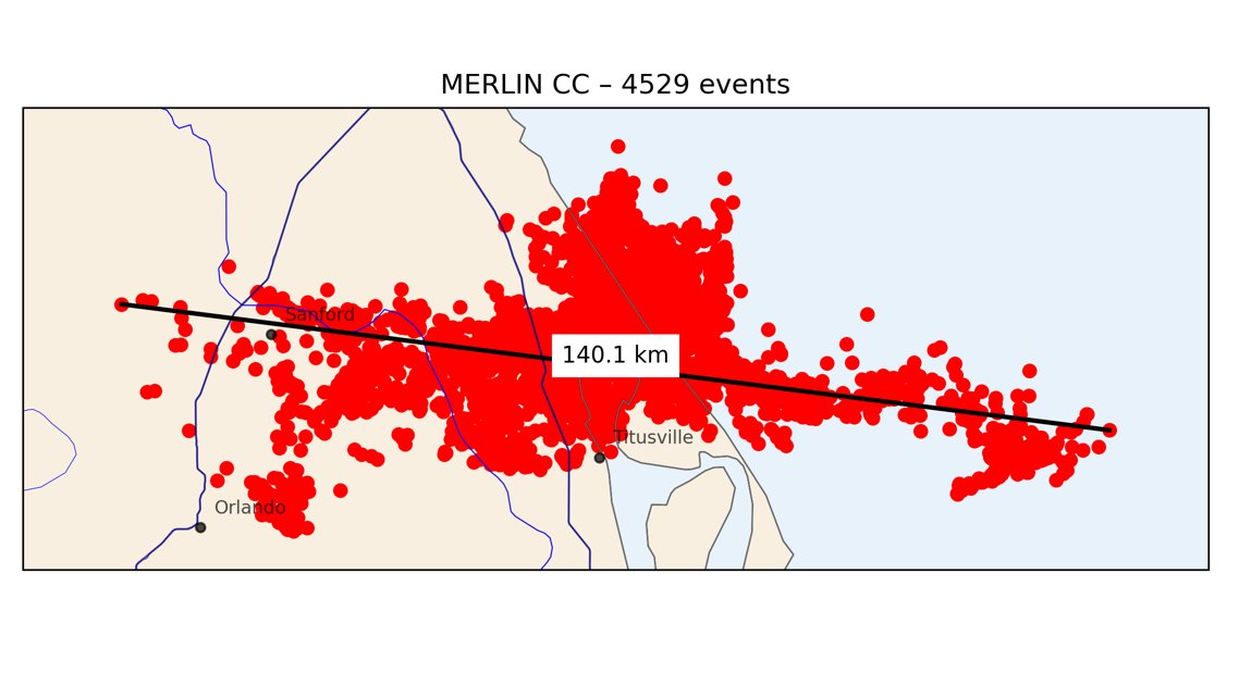
A preliminary, manual quality control of this lightning strike captured by <a href="/NASASpaceflight/">NSF - NASASpaceflight.com</a> cameras show a span of 140.1km/87.1mi, originating off the coast from a thunderstorm and traveling along the anvil towards the Orlando metro area. 
This is by far the longest span I have