Cody Nickel (@cnickelwrbl) 's Twitter Profile
Cody Nickel

@cnickelwrbl

| @WRBLNews3 Morning Meteorologist ☀️ | #Georgia Native 🍑 | @msstate Alumnus #HailState 🔔 | Email: [email protected] |

ID: 3003900958

linkhttp://wrbl.com/weather calendar_today28-01-2015 21:56:29

31,31K Tweet

1,1K Followers

1,1K Following

Bob Jeswald - WRBL (@bjeswaldwrbl) 's Twitter Profile Photo

3:44PM ET These thunderstorms across Russell County are not at severe levels but the forcing along the cool front is adding small hail, strong winds, torrential rainfall, and plenty of cloud to ground lightning strikes across the region. #alwx #gawx #wrblweather

NWS Atlanta (@nwsatlanta) 's Twitter Profile Photo

Cool, cloudy, and wet weather sticks around today across north & central GA. There is the potential for localized flooding in any areas that are hit with multiple rounds of heavy rain, especially this afternoon/evening. Stay weather-aware and have a way to get warnings! ⛈️ #gawx

Cool, cloudy, and wet weather sticks around today across north & central GA. There is the potential for localized flooding in any areas that are hit with multiple rounds of heavy rain, especially this afternoon/evening. Stay weather-aware and have a way to get warnings! ⛈️ #gawx
Nicole Phillips (@nicolephilli) 's Twitter Profile Photo

Good Sunday morning! Bulk of the rain in Atlanta this morning, a few showers spotty showers here at home but most remain cloudy and dry. Another round of rain and some rumbles of thunder today, keep in mind rain may be heavy this afternoon.

Nicole Phillips (@nicolephilli) 's Twitter Profile Photo

A "wedge" will keep our pattern cool and a little wet for the end of the weekend and the start of the work week. Look for scattered showers and storms today, rain could be heavy as well which could lead to flooding in some areas.

NWS Atlanta (@nwsatlanta) 's Twitter Profile Photo

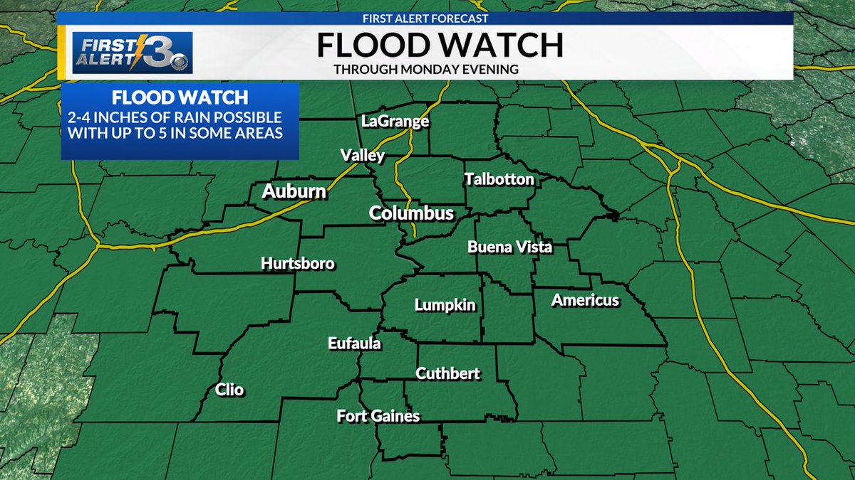
A flood watch has been issued for the western two-thirds of the area with rainfall amounts from 2-4 inches expected through Monday evening with locally higher amounts possible. Make sure to turn around, don't drown when encountering flooded roadways! 🌧️#gawx

A flood watch has been issued for the western two-thirds of the area with rainfall amounts from 2-4 inches expected through Monday evening with locally higher amounts possible. Make sure to turn around, don't drown when encountering flooded roadways! 🌧️#gawx
Nicole Phillips (@nicolephilli) 's Twitter Profile Photo

Flood Watch through Monday evening. Some areas have already received 1-3 inches of rain but an addition 2-4+ will be possible today through Monday

Flood Watch through Monday evening.

Some areas have already received 1-3 inches of rain but an addition 2-4+ will be possible today through Monday
NWS Weather Prediction Center (@nwswpc) 's Twitter Profile Photo

⛈️⚠️ A stationary front will linger across the Southeast this week, providing continued support for showers and thunderstorms. Prolonged moderate to heavy rain is expected to produce high rainfall totals that could result in scattered flash flooding. Turn around, don't drown!

⛈️⚠️ A stationary front will linger across the Southeast this week, providing continued support for showers and thunderstorms. Prolonged moderate to heavy rain is expected to produce high rainfall totals that could result in scattered flash flooding. Turn around, don't drown!
KayleeBarbeeWX (@kayleebarbeewx) 's Twitter Profile Photo

8/3/25 FLASH FLOOD WARNING: A Flash Flood Warning has been issued for parts of Clay County until 10PM ET this evening. Areas impacted include Bluffton, Fort Gaines, Zetto, and Suttons Corner.

8/3/25 FLASH FLOOD WARNING: A Flash Flood Warning has been issued for parts of Clay County until 10PM ET this evening. Areas impacted include Bluffton, Fort Gaines, Zetto, and Suttons Corner.
KayleeBarbeeWX (@kayleebarbeewx) 's Twitter Profile Photo

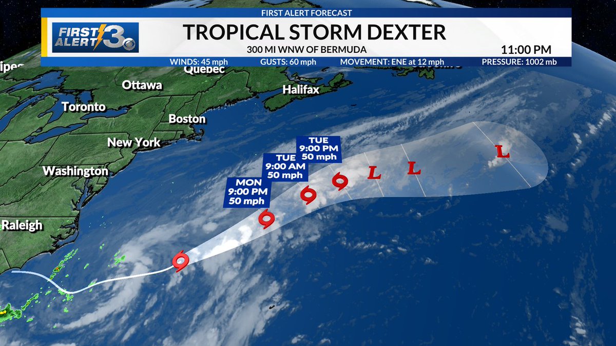
Tropical Storm #Dexter has formed in the Atlantic as of 11PM this evening. Dexter poses no threat to land and will continue to the northeast over the next few days. #Dexter #NHC #tropics

Tropical Storm #Dexter has formed in the Atlantic as of 11PM this evening. Dexter poses no threat to land and will continue to the northeast over the next few days.  #Dexter #NHC #tropics
Cody Nickel (@cnickelwrbl) 's Twitter Profile Photo

Good Monday morning! A cloudy, damp and cool start. Showers should increase in coverage as we go throughout the morning. #wrblwx #gawx #alwx

WRBL News 3 (@wrblnews3) 's Twitter Profile Photo

📰BACK TO SCHOOL & FEELING COOL📰The first day back in classes has us feeling nostalgic! Check out WRBL News 3 Cody Nickel's throwback picture.

📰BACK TO SCHOOL & FEELING COOL📰The first day back in classes has us feeling nostalgic! Check out WRBL News 3 Cody Nickel's throwback picture.
Cody Nickel (@cnickelwrbl) 's Twitter Profile Photo

CLAY & RANDOLPH: Watch out for areas of minor flooding. Heavy showers and a few rumbles of thunder continue to move into the area from the south. #wrblwx #gawx #alwx

Cody Nickel (@cnickelwrbl) 's Twitter Profile Photo

COMMUTE FORECAST: As the kiddos head back to school across Columbus this morning take it easy! Showers increase in coverage as we go throughout the morning and possibly a few rumbles of thunder possible later this evening. #wrblwx #gawx #alwx

COMMUTE FORECAST: As the kiddos head back to school across Columbus this morning take it easy! Showers increase in coverage as we go throughout the morning and possibly a few rumbles of thunder possible later this evening. #wrblwx #gawx #alwx
Cody Nickel (@cnickelwrbl) 's Twitter Profile Photo

Two different tropical storms are churning right now: Tropical Storm #Henriette in the Pacific and Tropical Storm #Dexter in the Atlantic. Here is what you need to know: #wrblwx #tropics #nhc wrbl.com/weather/tracki…

KayleeBarbeeWX (@kayleebarbeewx) 's Twitter Profile Photo

08/04/2025: A Flash Flood Warning has been issued for Clay and Randolph counties until 9:15 PM this evening. Flooding is ongoing or expected to begin shortly. #wrblwx #gawx