Collin Myers (@collinmyerswx) 's Twitter Profile
Collin Myers

@collinmyerswx

Award-Winning TV Meteorologist. Aerospace Engineer. Prev: Lead Met-@CBS Ind. Stations, @ABC & @FOXTV O&O’s | Harvey-17, Imelda-19 | OU. Dad & Husband. Job 23:10

ID: 3391169421

linkhttps://linktr.ee/collinmyers calendar_today28-07-2015 00:26:50

14,14K Tweet

13,13K Followers

883 Following

OSINTtechnical (@osinttechnical) 's Twitter Profile Photo

AIS tracks of Japanese fishing vessels rapidly evacuating port for the safety of deeper water earlier today as tsunami warnings were announced. Via MarineTraffic

Flightradar24 (@flightradar24) 's Twitter Profile Photo

Some flights diverting away from Hawaii as Hawaii is now in a tsunami warning after a M8.7 earthquake near the Kamchatka Peninsula. Hawaiian airports are open at the moment. flightradar24.com/multiview/3b7c…

Some flights diverting away from Hawaii as Hawaii is now in a tsunami warning after a M8.7 earthquake near the Kamchatka Peninsula. Hawaiian airports are open at the moment. flightradar24.com/multiview/3b7c…
Doc Remy LeBeau (@raccoonrocket_) 's Twitter Profile Photo

Collin Myers I took a couple of pictures of its evolution looking east from I-35 in Lewisville. First pic was at 7:43pm & 2nd pic was just 11 minutes later. It had some pretty explosive growth! (No filters applied.)
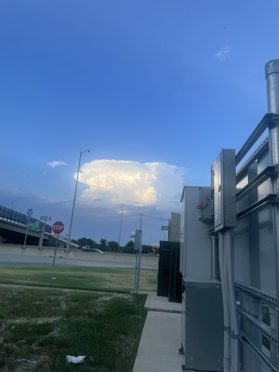
<a href="/collinmyerswx/">Collin Myers</a> I took a couple of pictures of its evolution looking east from I-35 in Lewisville. First pic was at 7:43pm &amp; 2nd pic was just 11 minutes later. It had some pretty explosive growth! (No filters applied.)
Collin Myers (@collinmyerswx) 's Twitter Profile Photo

NEW Precipitation Discussion: southern Oklahoma and North Texas, including #DFW and down into central Texas. Scattered storms should pick up in coverage soon, especially over populated areas. Locally, some areas could see 3” or even up to 5” of rain. Please be smart! #dfwwx

NEW Precipitation Discussion: southern Oklahoma and North Texas, including #DFW and down into central Texas. 

Scattered storms should pick up in coverage soon, especially over populated areas. 
Locally, some areas could see 3” or even up to 5” of rain. 

Please be smart!
#dfwwx
Collin Myers (@collinmyerswx) 's Twitter Profile Photo

#DFW: heads up. Outflow boundaries are converging on the metroplex main counties. Plenty of storm energy and instability is pooling in these spots. Strong storms with heavy rainfall potential and gusty winds are possible. Watching closely. #dfwwx #txwx

#DFW: heads up. Outflow boundaries are converging on the metroplex main counties. 
Plenty of storm energy and instability is pooling in these spots. 

Strong storms with heavy rainfall potential and gusty winds are possible. 

Watching closely. 
#dfwwx 
#txwx
Collin Myers (@collinmyerswx) 's Twitter Profile Photo

Watching these two outflow boundaries. Roughly less than an hour before they collide. This collision should spark convection, some of which could be heavy. 7:00pm #dfwwx #txwx

Watching these two outflow boundaries. 
Roughly less than an hour before they collide. 

This collision should spark convection, some of which could be heavy. 

7:00pm
#dfwwx 
#txwx
Collin Myers (@collinmyerswx) 's Twitter Profile Photo

“LIFE-THREATENING FLASH FLOODING” south of New Braunfels now. Issued at 7:45pm through the next two and a half hours. 2-4” of rain has fallen and another 1, maybe 2” are possible. Dangerous situation unfolding between Austin and San Antonio. #txwx

“LIFE-THREATENING FLASH FLOODING” south of New Braunfels now. Issued at 7:45pm through the next two and a half hours. 
2-4” of rain has fallen and another 1, maybe 2” are possible. 

Dangerous situation unfolding between Austin and San Antonio.

#txwx
Collin Myers (@collinmyerswx) 's Twitter Profile Photo

1:00pm, #DFW - heads up. A strengthening convective line is emerging on remnant outflow across populated areas. Some of these storms are strong and I wouldn’t be surprised to see a severe warning or two for winds to 60mph. Lots of lightning in these too. #dfwwx #txwx

1:00pm, #DFW - heads up. A strengthening convective line is emerging on remnant outflow across populated areas. Some of these storms are strong and I wouldn’t be surprised to see a severe warning or two for winds to 60mph. 
Lots of lightning in these too. 

#dfwwx 
#txwx
Collin Myers (@collinmyerswx) 's Twitter Profile Photo

1:05pm-NOW a *Severe Thunderstorm Warning* for winds to 60mph on this line approaching DFW Airport. Small coin hail and active lightning are also in this. #dfwwx #txwx
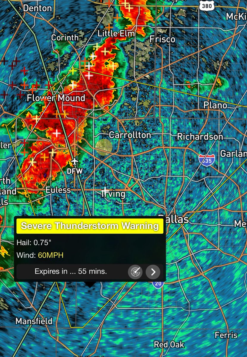
1:05pm-NOW a *Severe Thunderstorm Warning* for winds to 60mph on this line approaching <a href="/DFWAirport/">DFW Airport</a>. Small coin hail and active lightning are also in this. 

#dfwwx #txwx
Collin Myers (@collinmyerswx) 's Twitter Profile Photo

Strong thunderstorms holding together this AM, diving SE towards metro #DFW. Sub-severe now with small hail, winds to ~55mph. 3:00am #dfwwx #txwx

Strong thunderstorms holding together this AM, diving SE towards metro #DFW. 
Sub-severe now with small hail, winds to ~55mph. 

3:00am
#dfwwx 
#txwx
Collin Myers (@collinmyerswx) 's Twitter Profile Photo

3:03am: new Severe Thunderstorm Warning, diving into heavily populated Collin county this AM. Winds to 60mph, nickel and dime hail. Lots of lightning in this. #dfwwx

3:03am: new Severe Thunderstorm Warning, diving into heavily populated Collin county this AM. 

Winds to 60mph, nickel and dime hail. 
Lots of lightning in this.

#dfwwx
Collin Myers (@collinmyerswx) 's Twitter Profile Photo

9:55am - Houston & SE Texas, the strong line of convection is on final approach. Winds have weakened a bit, but still pack a punch up to ~50-55mph or so.

9:55am - Houston &amp; SE Texas, the strong line of convection is on final approach. Winds have weakened a bit, but still pack a punch up to ~50-55mph or so.