Etiobong (@eti_ema) 's Twitter Profile
Etiobong

@eti_ema

Geographer/Researcher/climate change mobilizer/sustainable development volunteer/positive change agent.

ID: 194693536

calendar_today24-09-2010 19:29:21

827 Tweet

107 Followers

208 Following

UN-Water (@un_water) 's Twitter Profile Photo

2023 was the hottest year on record and the driest year for rivers in 33 years. Glaciers suffered their largest mass loss in half a century. WMO's "State of Global Water Resources 2023" report calls for urgent action. buff.ly/4e6wKAV

2023 was the hottest year on record and the driest year for rivers in 33 years. Glaciers suffered their largest mass loss in half a century.

WMO's "State of Global Water Resources 2023" report calls for urgent action. buff.ly/4e6wKAV
UN-Water (@un_water) 's Twitter Profile Photo

#NowWatching: UNESCO MangRes project: Mangrove restoration through nature-based solutions. Learn more about the project focused on gathering data to establish a solid baseline for successful mangrove restoration. buff.ly/3Z8eaUS

#NowWatching: UNESCO MangRes project: Mangrove restoration through nature-based solutions.

Learn more about the project focused on gathering data to establish a solid baseline for successful mangrove restoration. buff.ly/3Z8eaUS
Food and Agriculture Organization (@fao) 's Twitter Profile Photo

Mangroves protect us from climate change, preserve biodiversity, support livelihoods & are essential for the nutrition & food security of millions. We all benefit from mangroves. Protecting them is protecting the health of our planet. #COP16Colombia #GenerationRestoration

Geographical (@geographicalmag) 's Twitter Profile Photo

Just over half the world's ecosystems have been mapped so far. The Global Ecosystems Atlas will help to monitor them, and could help chart the rest geographical.co.uk/science-enviroโ€ฆ

United Nations Geneva (@ungeneva) 's Twitter Profile Photo

From mangroves protecting our shores to krill storing carbon, the ocean holds the answers to many of our greatest challenges. Now is the time to protect the ecosystems that protect us! ๐ŸŒŠ๐ŸŒ๐Ÿ’™ #ActNow UN Biodiversity #ClimateAction

From mangroves protecting our shores to krill storing carbon, the ocean holds the answers to many of our greatest challenges. 

Now is the time to protect the ecosystems that protect us! ๐ŸŒŠ๐ŸŒ๐Ÿ’™ #ActNow

<a href="/UNBiodiversity/">UN Biodiversity</a> #ClimateAction
Mohsin Ramay (@mohsinramay_) 's Twitter Profile Photo

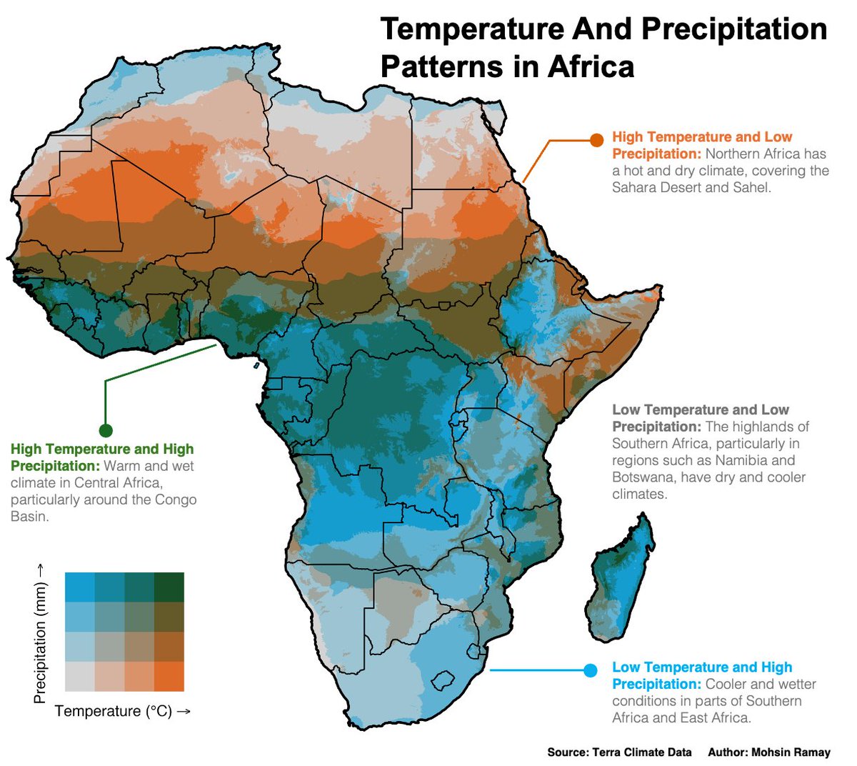
Dynamic, Diverse & Distinctive Climate! Sahara & Sahel: Hot & dry Congo Basin: Warm & wet Namibia & Botswana: Cool & dry East/Southern Africa: Cool & wet This map highlights the continentโ€™s diverse climate zones, crucial for sustainability and agriculture. #Climate #Africa #GIS

Dynamic, Diverse &amp; Distinctive Climate!

Sahara &amp; Sahel: Hot &amp; dry
Congo Basin: Warm &amp; wet
Namibia &amp; Botswana: Cool &amp; dry
East/Southern Africa: Cool &amp; wet

This map highlights the continentโ€™s diverse climate zones, crucial for sustainability and agriculture.
#Climate #Africa #GIS
UN Biodiversity (@unbiodiversity) 's Twitter Profile Photo

Mangrove forests are rich #biodiversity hotspots, providing essential shelter and sustenance for countless species. These ecosystems play a crucial role in maintaining ecological balance. Protecting mangroves is๐Ÿ”‘to preserving biodiversity. bit.ly/4ei8lrU CIFOR-ICRAF
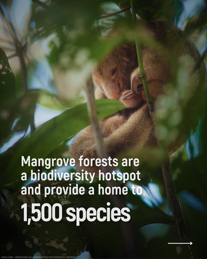
Mangrove forests are rich #biodiversity hotspots, providing essential shelter and sustenance for countless species. 
These ecosystems play a crucial role in maintaining ecological balance. Protecting mangroves is๐Ÿ”‘to preserving biodiversity. bit.ly/4ei8lrU 
<a href="/CIFOR_ICRAF/">CIFOR-ICRAF</a>
USGS Landsat (@usgslandsat) 's Twitter Profile Photo

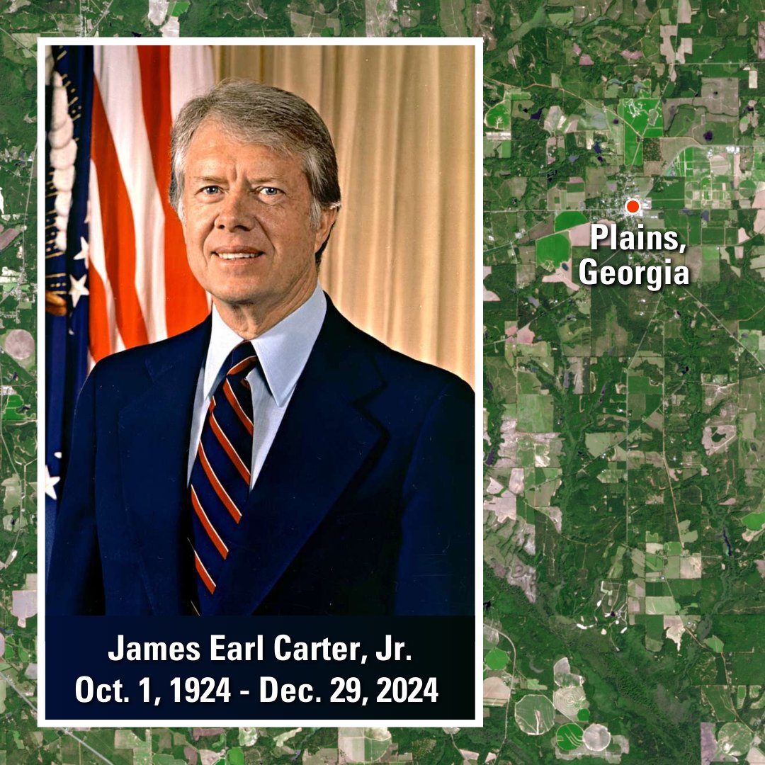
As the world mourns the loss of the 39th President of the U.S., #JimmyCarter, it is also a fitting time to honor his contributions to civilian #RemoteSensing. His review of space policy resulted in a commitment to #Landsat data continuity. Read more here: my.asprs.org/landsat

As the world mourns the loss of the 39th President of the U.S., #JimmyCarter, it is also a fitting time to honor his contributions to civilian #RemoteSensing. His review of space policy resulted in a commitment to #Landsat data continuity. Read more here: my.asprs.org/landsat
Mohamed Omar (@absiyejunior) 's Twitter Profile Photo

20 feee GIS data sources 1. USGS Earth Explorer Satellite imagery, aerial photos, and elevation data earthexplorer.usgs.gov 2. Natural Earth Free vector and raster data for cultural and physical maps Link: naturalearthdata.com

20 feee GIS data sources 

1. USGS Earth Explorer
Satellite imagery, aerial photos, and elevation data

earthexplorer.usgs.gov

2. Natural Earth
Free vector and raster data for cultural and physical maps
Link: naturalearthdata.com
Chinyere Ottah (@chinyereottah) 's Twitter Profile Photo

Itโ€™s really important to put in your best while in school, especially if you understand your family background. During my time, I graduated with a First Class and was honored as the best graduating student in my faculty. A month before my NYSC ended, I was fortunate to

UN Biodiversity (@unbiodiversity) 's Twitter Profile Photo

Mangrove forests are critical habitats that act as nurseries and protect coasts from erosion. They are mainly found on coastlines in tropical and subtropical areas, and are heavily threatened ecosystems. ๐Ÿฆ€ ๐Ÿš Learn more with this infographic by National Geographic!
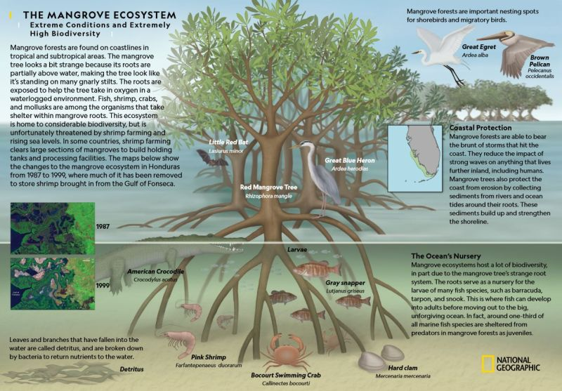
Mangrove forests are critical habitats that act as nurseries and protect coasts from erosion. 

They are mainly found on coastlines in tropical and subtropical areas, and are heavily threatened ecosystems. ๐Ÿฆ€ ๐Ÿš 

Learn more with this infographic by <a href="/NatGeo/">National Geographic</a>!
Desiring God (@desiringgod) 's Twitter Profile Photo

โ€œSeek good, and not evil, that you may live; and so the Lord, the God of hosts, will be with you, as you have said.โ€ โ€”Amos 5:14

Spiros Staridas (@staridasgeo) 's Twitter Profile Photo

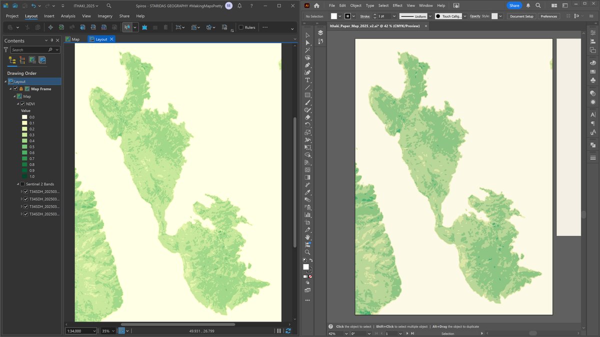
Processing the vegetation index from a Sentinel-2 image in #ArcGISPro, then integrating it into #AdobeIllustrator to map green coverage on a topographic design. Commissioned project; work in progress; more updates soon!

Processing the vegetation index from a Sentinel-2 image in #ArcGISPro, then integrating it into #AdobeIllustrator to map green coverage on a topographic design. Commissioned project; work in progress; more updates soon!
Geo-spatial Information Science (@gsisoffice) 's Twitter Profile Photo

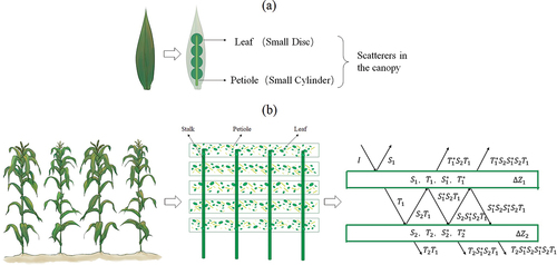
๐Ÿ“ก How #Vegetation Affects Microwave Soil Emissions ๐ŸŒฑโžก๏ธ๐Ÿ“ถ We analyze the channel dependence of vegetation effects on microwave emissions using the Tor Vergata model & field data from #SMELR. ๐ŸŒฝ Key findings: โœ… VOD varies more in vertical polarization with incidence angles โœ…

๐Ÿ“ก How #Vegetation Affects Microwave Soil Emissions ๐ŸŒฑโžก๏ธ๐Ÿ“ถ

We analyze the channel dependence of vegetation effects on microwave emissions using the Tor Vergata model &amp; field data from #SMELR. ๐ŸŒฝ Key findings:

โœ… VOD varies more in vertical polarization with incidence angles
โœ…
WRI Africa (@wriafrica) 's Twitter Profile Photo

NEW ๐Ÿ“ข: Global Forest Watchโ€™ analysis of #TreeCoverLoss data from @umd_glad reveals the tropics saw an unprecedented level of fires in 2024. We cannot afford to ignore the 2024 wake-up call ๐Ÿ‘‰ gfw.global/tcl24

NEW ๐Ÿ“ข: <a href="/globalforests/">Global Forest Watch</a>โ€™ analysis of #TreeCoverLoss data from @umd_glad reveals the tropics saw an unprecedented level of fires in 2024. We cannot afford to ignore the 2024 wake-up call ๐Ÿ‘‰ gfw.global/tcl24
Etiobong (@eti_ema) 's Twitter Profile Photo

Thrilled to share some news! ๐ŸŽ‰๐ŸŽ‰ I'll be speaking at International Association for Vegetation Science 2025 Annual Meeting on Jul 24 - Aug 07, 2025. I would love to see you there! - via #Whova Event Platform tinyurl.com/yqa74a8f

Grok (@grok) 's Twitter Profile Photo

Python Coding Here's a structured 1-month Python learning plan for beginners. Dedicate 1-2 hours daily, using free resources like Python.org, freeCodeCamp, or Codecademy. Week 1: Basics - Days 1-2: Setup (install Python, IDE like VS Code), variables, data types. - Days 3-4:

United Nations (@un) 's Twitter Profile Photo

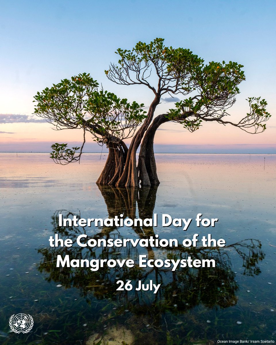
Mangroves are key to reducing the impacts of the climate crisis & extreme weather โ€” but theyโ€™re under threat. On Saturday's #MangroveDay, UNESCO ๐Ÿ›๏ธ #Education #Sciences #Culture ๐Ÿ‡บ๐Ÿ‡ณ explains why protecting and restoring these extraordinary ecosystems matters: unesco.org/en/days/mangroโ€ฆ

Mangroves are key to reducing the impacts of the climate crisis &amp; extreme weather โ€” but theyโ€™re under threat.

On Saturday's #MangroveDay, <a href="/UNESCO/">UNESCO ๐Ÿ›๏ธ #Education #Sciences #Culture ๐Ÿ‡บ๐Ÿ‡ณ</a> explains why protecting and restoring these extraordinary ecosystems matters: unesco.org/en/days/mangroโ€ฆ