Chris Gale (@geogale) 's Twitter Profile
Chris Gale

@geogale

Dr of Geography; Head of Geospatial @HomesEngland, Ex-@ONSGeography; creator of the 2011 OAC; fan of maps and occasional tweeter

ID: 234829803

linkhttp://geogale.github.io/2011OAC/ calendar_today06-01-2011 17:38:13

389 Tweet

582 Followers

95 Following

ONS Geography (@onsgeography) 's Twitter Profile Photo

ONS Geography are taking part in the #30DayMapChallenge showcasing some of our work and data sources! Day1: Points - Here's a comparison between Output Area population weighted centroids and geometric centroids. #points Office for National Statistics (ONS) ONS Focus

ONS Geography are taking part in the #30DayMapChallenge showcasing some of our work and data sources! Day1: Points - Here's a comparison between Output Area population weighted centroids and geometric centroids. #points <a href="/ONS/">Office for National Statistics (ONS)</a> <a href="/ONSfocus/">ONS Focus</a>
Chris Gale (@geogale) 's Twitter Profile Photo

Do you fancy being a Senior Geospatial Analyst Office for National Statistics (ONS)? If so, then this might be the job for you: civilservicejobs.service.gov.uk/csr/index.cgi?… If you want any further details or a chat about the post then feel free to get in touch. ONS Geography Government Geography Profession

Chris Gale (@geogale) 's Twitter Profile Photo

There are 44 maps in the Levelling Up White Paper (excluding the front cover & the USA map) - my team made 16 of them and edited/provided feedback on a further 12 - so shall we call that 64% of the mapness of the WP involved BM, SpatialMac & @geojordan96! Good work team!

GISRUK (@gisruk) 's Twitter Profile Photo

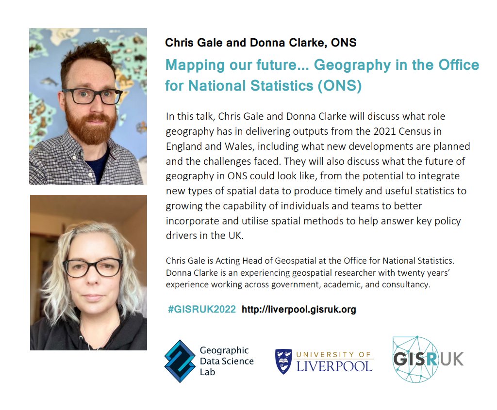
And last but by no means least... for our third #GISRUK2022 keynote we will be hearing from the fantastic Chris Gale & Donna Clarke from ONS Geography about all the exciting geospatial developments with the latest UK #Census2021! 🤩🧮
And last but by no means least... for our third #GISRUK2022 keynote we will be hearing from the fantastic <a href="/geogale/">Chris Gale</a> &amp; Donna Clarke from <a href="/ONSgeography/">ONS Geography</a> about all the exciting geospatial developments with the latest UK #Census2021! 🤩🧮
Chris Gale (@geogale) 's Twitter Profile Photo

Interested in the more technical side of spatial data and want a job Office for National Statistics (ONS)? Then we have two vacancies you might be interested in: civilservicejobs.service.gov.uk/csr/index.cgi?… and civilservicejobs.service.gov.uk/csr/index.cgi?…

Chris Gale (@geogale) 's Twitter Profile Photo

Leaving Liverpool after a great #GISRUK2022. It was great to see some fantastic applications of GIS (with many using Office for National Statistics (ONS) data). Was also great to see how keen people were to learn what we do in ONS Geography and what opportunities exist. Something for me, ONS and Government Geography Profession to 🤔

Chris Gale (@geogale) 's Twitter Profile Photo

This feels like a question I should know the answer to... does anyone know which UK Government Department holds the definitive list of cities in the UK?

Chris Gale (@geogale) 's Twitter Profile Photo

Congrats to ⁦ONS Geography⁩ team for winning ‘Advancing Geospatial Data Science’ 🏆 at ⁦⁦Government Geography Profession⁩ #GiG2022 awards. Also 🎉 to my team who were shortlisted in the ‘Excellence in Geo-visualisation’ category! And as an added bonus, got to experience #ElizabethLine!

ONS Geography (@onsgeography) 's Twitter Profile Photo

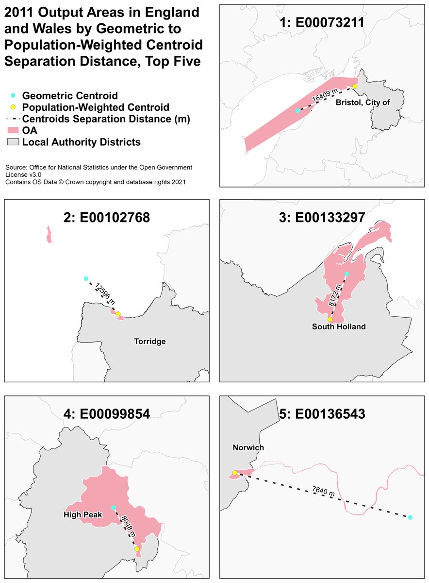
With a new census comes new population-weighted centroids! These are the five Output Areas with the largest distance moved between 2011 and 2021 centroids. Check out the latest centroids here: geoportal.statistics.gov.uk/search?collect…) #30DayMapChallenge #Points #QGIS

With a new census comes new population-weighted centroids! These are the five Output Areas with the largest distance moved between 2011 and 2021 centroids. Check out the latest centroids here: geoportal.statistics.gov.uk/search?collect…) #30DayMapChallenge #Points
 #QGIS
ONS Geography (@onsgeography) 's Twitter Profile Photo

The administrative geography of Britain is complex and subject to change through time. In 1921 there were 1,827 districts in England and Wales comprised of Counties, Boroughs, Urban, Rural and Metropolitan Districts, plus the City of London #30DayMapChallenge #Polygons #ArcMap

The administrative geography of Britain is complex and subject to change through time.  
In 1921 there were 1,827 districts in England and Wales comprised of Counties, Boroughs, Urban, Rural and Metropolitan Districts, plus the City of London #30DayMapChallenge #Polygons
 #ArcMap
ONS Geography (@onsgeography) 's Twitter Profile Photo

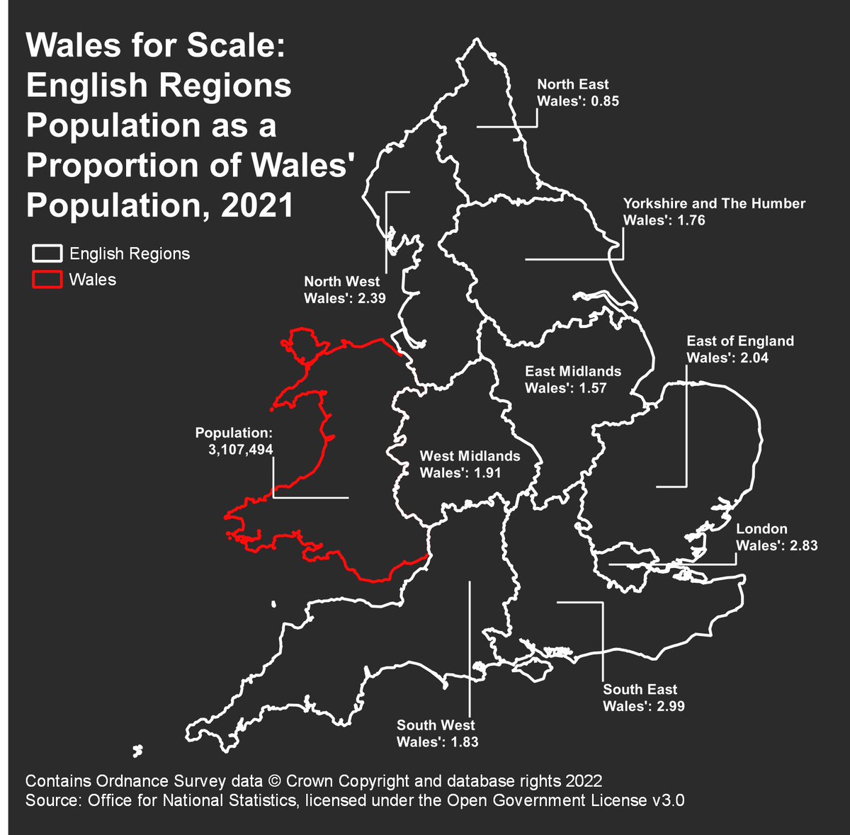
There are many unusual units of measurement out there, but my favourite is my home country: Wales! Here are the populations of England’s regions, as a proportion of Wales’ population! #30DayMapChallenge #Scale #QGIS Map by @geojordan96

There are many unusual units of measurement out there, but my favourite is my home country: Wales! Here are the populations of England’s regions, as a proportion of Wales’ population! #30DayMapChallenge #Scale #QGIS Map by @geojordan96
ONS Geography (@onsgeography) 's Twitter Profile Photo

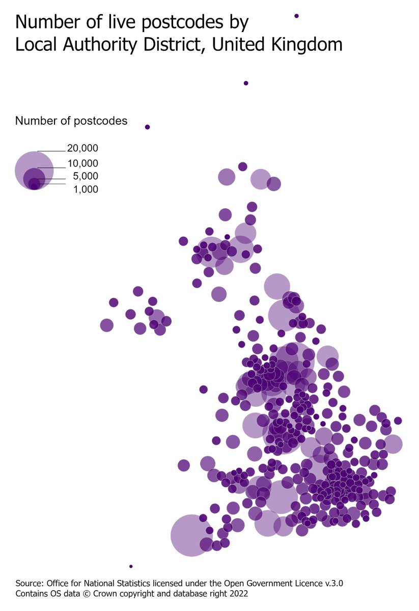
Sometimes simple is better. Today's map reveals some unexpected surprises when looking at the number of postcodes in areas such as Cornwall, Wiltshire and Buckinghamshire, where the population densities are at the lower end of the scale. #30DayMapChallenge #Minimal #ArcGISPro

Sometimes simple is better. Today's map reveals some unexpected surprises when looking at the number of postcodes in areas such as Cornwall, Wiltshire and Buckinghamshire, where the population densities are at the lower end of the scale. #30DayMapChallenge #Minimal #ArcGISPro
ONS Geography (@onsgeography) 's Twitter Profile Photo

Geographies in UK change over time. Most analysts have stumbled across this by accident when joining data to boundaries and finding some NULLs... so here we present Local Authority District NULLs since 2019. #30DayMapChallenge #Day22 #NULL

Geographies in UK change over time. Most analysts have stumbled across this by accident when joining data to boundaries and finding some NULLs... so here we present Local Authority District NULLs since 2019. #30DayMapChallenge #Day22 #NULL
The Geographical Journal (@geogjournal) 's Twitter Profile Photo

🔉New paper published in #GJ by Jakub Wyszomierski, Paul A. Longley, Alex D. Singleton, Christopher Gale, and Oliver O'Brien. 'A neighbourhood Output Area Classification from the 2021 and 2022 UK censuses'. #OpenAccess doi.org/10.1111/geoj.1…

🔉New paper published in #GJ by <a href="/kuba_wyszo/">Jakub Wyszomierski</a>, Paul A. Longley, Alex D. Singleton, Christopher Gale, and <a href="/oobr/">Oliver O'Brien</a>.

'A neighbourhood Output Area Classification from the 2021 and 2022 UK censuses'. #OpenAccess 

doi.org/10.1111/geoj.1…