
its4land
@its4land1
We're an EU H2020 project creating 7 new tools to make land rights mapping faster, cheaper, easier, and more responsible
ID: 702791956183851008
http://its4land.com 25-02-2016 09:47:14
1,1K Tweet
445 Followers
361 Following


Upcoming webinar about how #EarthObservation and #DeepLearning can map social inequalities by one of the IADF working group leads Claudio Persello. Not to be missed!

Mapping urban deprivation and socio-economic inequalities using earth observation and deep learning. Join our webinar tomorrow! @LibITC IEEE Geoscience and Remote Sensing Society #DeepLearning us02web.zoom.us/meeting/regist…

GATE Big Data and Artificial Intelligence Forum 10'th of December 2020 Join us 10 30 AM (CET) Facebook facebook.com/GATECoE/live/ YouTube youtu.be/Nl4d-fatEq0 Faculty ITC | University of Twente ITC Alumni (inactive) GeoVis @ ITC now https://mapstodon.space/@GeoVisUT @LibITC


Congrats, Vicky! The importance of 3D models for urban analysis: Making the Third Dimension (3D) Explicit in Hedonic Price Modelling: A Case Study of Xi’an, China mdpi.com/940632 via MDPI ITC Alumni (inactive) Faculty ITC | University of Twente @LibITC Women+ in Geospatial

We have a vacancy welcome to check it:) utwente.nl/en/organisatio… ITC Alumni (inactive) @LibITC Faculty ITC | University of Twente


Are you interested in deep learning for glacier mapping? Check out our open PhD position. IEEE Geoscience and Remote Sensing Society ISPRS @LibITC Faculty ITC | University of Twente #IGARSS2021 utwente.nl/en/organisatio…


Great news - SmartLandMaps won the Start-Up Transfer NRW grant to accelerate its endeavors to document land rights! Thanks to the jury and our supporters for your trust. Kees de Zeeuw Malumbo Chipofya @Peter_Rabley 🚀🚀🚀 exist.de/SharedDocs/Kur…

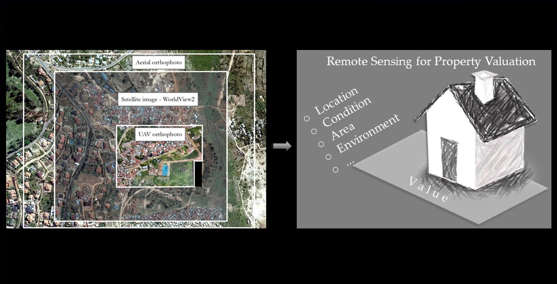
Check out our new publication:) Remote Sensing for Property Valuation: A Data Source Comparison in Support of Fair Land Taxation in Rwanda mdpi.com/2072-4292/13/1… ITC Alumni (inactive) @LibITC Faculty ITC | University of Twente University of Twente (inactive)

The GEO-GEE project 'large scale high resolution detection of vulnerable settlements' has published a great paper on how they are fighting poverty using satellite imagery to track the growth of vulnerable settlements in Mexico. Read the paper👇 bit.ly/3kKyFSY Group on Earth Observations


Welcome to see my keynote speech at 3D GeoInfo 2021 New York about photogrammetry and 3D modelling for PLUS. Video: vimeo.com/636094791/fcfb… Faculty ITC | University of Twente University of Twente (inactive) ITC Alumni (inactive) @LibITC ISPRS IEEE Geoscience and Remote Sensing Society

Chaki ball project received the Geospatial Innovation World award 2021! It is a great honor! Congratulations UT, WWU, KUL, HL, Esri Rwanda, BDU, INES, TUK! University of Twente (inactive) University of Twente (inactive) ITC Alumni (inactive) Faculty ITC | University of Twente World Bank Africa GIM International ISPRS FIG Kadaster Int.

Dessislava Petrova-Antonova, GATE and Anders Logg, Chalmers University of Technology, will speak at the GATE session “Data Spaces Enabling City Digital Twins” -online on December 2, 2021 (11.00 – 12.00 CET) as part of the European Big Data Value Forum (#EBDVF21). 👉european-big-data-value-forum.eu
