Jessica Daniela O. Falcon (@jdofalcon) 's Twitter Profile
Jessica Daniela O. Falcon

@jdofalcon

Spatial Data Scientist | GeoAI | GIScience 🛰️ Fdo @RLadiesVhsa 'n @rladiesmid 🌺

ID: 562268401

linkhttp://beacons.page/jdofalcon calendar_today24-04-2012 19:10:21

3,3K Tweet

351 Followers

336 Following

La Sandía Digital 💜 💚 🏳️‍⚧️ 🇲🇽 (@lasandiadigital) 's Twitter Profile Photo

💗¡Gran noticia! 📻 Este año iniciarán las transmisiones la #RadioComunitaria Chontal para fortalecer la lucha del pueblo Chontal por la #DefensaDelTerritorio y contra la #minería en #Oaxaca 🌿✊🏽 ojodeaguacomunicacion.org/inicia-en-2024…

Palestina Hoy (@palestinahoy01) 's Twitter Profile Photo

🚨 ÚLTIMA HORA 💔🇵🇸 Un mensaje de despedida, el personal médico del complejo Nasser en Khan Younis de hoy : - Ahora mismo estamos trabajando en el hospital, y los tanques están a solo unos metros de nosotros. Estamos más cerca de la muerte que de la vida. - Los soldados no

Instituto de Geografía UNAM (@igeografiaunam) 's Twitter Profile Photo

El Instituto de Geografía de la UNAM informa que la doctora Julie Anne Boudreau, académica de esta entidad, se encuentra desarrollando un documental sobre los procesos de gentrificación en distintas zonas urbanas del país.

Kirk Borne (@kirkdborne) 's Twitter Profile Photo

"Agent-Based Modelling and Geographical Information Systems: A Practical Primer (#GeoSpatial Analytics and #GIS)" amzn.to/3b26CK9 ————— #DataScience #AI #ComputationalScience #SocialScience #AgentBasedModeling #NetworkScience #SpatialAnalysis #Simulation

"Agent-Based Modelling and Geographical Information Systems: A Practical Primer (#GeoSpatial Analytics and #GIS)" amzn.to/3b26CK9
—————
#DataScience #AI #ComputationalScience #SocialScience #AgentBasedModeling #NetworkScience #SpatialAnalysis #Simulation
Kirk Borne (@kirkdborne) 's Twitter Profile Photo

Learn both how to build and how to ship #ML models into production >> "Building #MachineLearning Powered Applications — Going from Idea to Product": amzn.to/38aaWTG by Emmanuel Ameisen ————— #DataScience #AI #DataScientist #MLOps

Learn both how to build and how to ship #ML models into production &gt;&gt; "Building #MachineLearning Powered Applications — Going from Idea to Product": amzn.to/38aaWTG by <a href="/mlpowered/">Emmanuel Ameisen</a>
—————
#DataScience #AI #DataScientist #MLOps
Julio Astillero (@julioastillero) 's Twitter Profile Photo

🚢 #PonteAlCorriente con #EntrevistasAstilladas Entrevista con Carla Escoffié del 7 de julio de 2025 Protestas, no por querer vivir gratis en zonas “nice”, sino por desplazamientos: Escoffié buff.ly/Qd9EEyW

🚢 #PonteAlCorriente con #EntrevistasAstilladas

Entrevista con <a href="/carlaescoffie/">Carla Escoffié</a> del 7 de julio de 2025

Protestas, no por querer vivir gratis en zonas “nice”, sino por desplazamientos: Escoffié

buff.ly/Qd9EEyW

Remote Sensing MDPI (@remotesens_mdpi) 's Twitter Profile Photo

👋👋 Characterizing Chromophoric #Dissolved #OrganicMatter Spatio-Temporal Variability in North #Andean #Patagonian #Lakes Using #RemoteSensing Information and Environmental Analysis ✍️ Ayelén Sánchez Valdivia et al. 🔗 brnw.ch/21wU6Ku

👋👋 Characterizing Chromophoric #Dissolved #OrganicMatter Spatio-Temporal Variability in North #Andean #Patagonian #Lakes Using #RemoteSensing Information and Environmental Analysis

✍️ Ayelén Sánchez Valdivia et al.
🔗 brnw.ch/21wU6Ku
Alex Villamar (@alexelvilli) 's Twitter Profile Photo

¿Por qué pedimos que se regule? Llegará un punto donde no existan filtros de seguridad y gente que usa la IA para estafar, PONDRÁ EN RIESGO TÚ INTEGRIDAD. Si, estamos viviendo otra revolución industrial enfocado a la tecnología. Si nosotros perdemos, EL SIGUIENTE SERÁS TÚ.

Remote Sensing MDPI (@remotesens_mdpi) 's Twitter Profile Photo

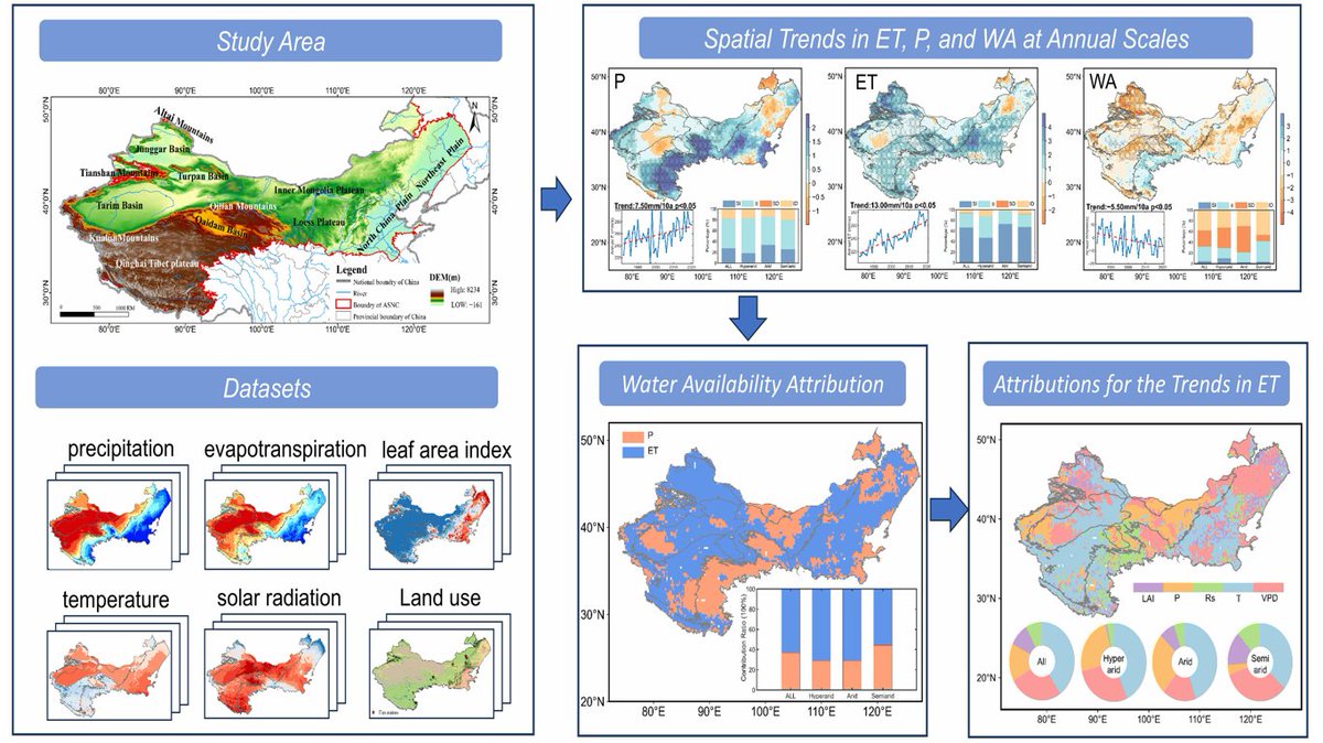
💧💧 #Spatiotemporal Variations and Driving Factors of #Water Availability in the #Arid and #Semiarid Regions of Northern #China ✍️ Xiaoyu Han et al. 🔗 brnw.ch/21wU9LT

💧💧 #Spatiotemporal Variations and Driving Factors of #Water Availability in the #Arid and #Semiarid Regions of Northern #China

✍️ Xiaoyu Han et al.
🔗 brnw.ch/21wU9LT
Instituto de Geografía UNAM (@igeografiaunam) 's Twitter Profile Photo

El Centro de Investigaciones en Geografía Ambiental UNAM tiene un libro sobre Geoprocesamiento con Phyton 🌐 En el manual introductorio para el procesamiento de imágenes satelitales. Descárgalo libremente 📥publicaciones.ciga.unam.mx/index.php/ec/c…

El Centro de Investigaciones en Geografía Ambiental UNAM tiene un libro sobre Geoprocesamiento con Phyton 🌐
En el manual introductorio para el procesamiento de imágenes satelitales.

Descárgalo libremente 📥publicaciones.ciga.unam.mx/index.php/ec/c…